Minisink Ford, New York

Last updated
Minisink Ford
hamlet
USA New York location map.svg
Red pog.svg
Minisink Ford
Location within the state of New York
Coordinates: 41°28′57″N74°58′37″W / 41.48250°N 74.97694°W / 41.48250; -74.97694 Coordinates: 41°28′57″N74°58′37″W / 41.48250°N 74.97694°W / 41.48250; -74.97694
Country United States
State New York
County Sullivan
Elevation 860 ft (260 m)
Time zone Eastern (EST) (UTC-5)
  Summer (DST) EDT (UTC-4)
GNIS feature ID 972805 [1]

Minisink Ford is a hamlet on the Delaware River fifteen miles northwest of Port Jervis. It is in the town of Highland, Sullivan County, New York, in the United States.

Delaware River major river on the East coast of the United States of America

The Delaware River is a major river on the Atlantic coast of the United States. It drains an area of 14,119 square miles (36,570 km2) in five U.S. states: Delaware, Maryland, New Jersey, New York, Pennsylvania. Rising in two branches in New York state's Catskill Mountains, the river flows 419 miles (674 km) into Delaware Bay where its waters enter the Atlantic Ocean near Cape May in New Jersey and Cape Henlopen in Delaware. Not including Delaware Bay, the river's length including its two branches is 388 miles (624 km). The Delaware River is one of nineteen "Great Waters" recognized by the America's Great Waters Coalition.

Port Jervis, New York City in New York, United States

Port Jervis is a city located at the confluence of the Neversink and the Delaware rivers in western Orange County, New York, north of the Delaware Water Gap. Its population was 8,828 at the 2010 census. The communities of Deerpark, Huguenot, Sparrowbush, and Greenville are adjacent to Port Jervis. Matamoras, Pennsylvania is across the river and connected by bridge. Montague Township, New Jersey borders here.

Highland, Sullivan County, New York town in New York

Highland is a town in Sullivan County, New York, United States. The population was 2,530 at the 2010 census. The town's name notes its location on elevated ground north of the Delaware River. The town is in the southwest part of the county.

Contents

History

"Minisink" once referred to a vast area stretching all the way from Minisink Ford to the Delaware Water Gap. In 1800, the Town of Minisink was given its present boundaries, thirty miles southwest of Minisink Ford.

Delaware Water Gap

The Delaware Water Gap is a water gap on the border of the U.S. states of New Jersey and Pennsylvania where the Delaware River cuts through a large ridge of the Appalachian Mountains. The gap constitutes the southern portion of the Delaware Water Gap National Recreation Area, which is used primarily for recreational purposes, such as rafting, canoeing, swimming, fishing, hiking, and rock climbing.

Minisink, New York Town in New York, United States

Minisink is a town located in southwest Orange County, New York northeast of the New Jersey border between the Town of Greenville and the Town of Warwick. The population was 4,490 at the 2010 census. The town is located near Interstate 84 and New York State Route 17 and lies about halfway between New York City and Scranton, Pa.

During the American Revolution in 1779 Minisink Ford was the site of the Battle of Minisink in which 4050 settlers were killed in an engagement with a band of Iroquois and Loyalists under Mohawk chief and Colonel Joseph Brant. The Minisink Battlefield was listed on the National Register of Historic Places in 1993. [2]

American Revolution Colonial revolt in which the Thirteen Colonies won independence from Great Britain

The American Revolution was a colonial revolt that took place between 1765 and 1783. The American Patriots in the Thirteen Colonies won independence from Great Britain, becoming the United States of America. They defeated the British in the American Revolutionary War (1775–1783) in alliance with France and others.

Battle of Minisink

The Battle of Minisink was a battle of the American Revolutionary War fought at Minisink Ford, New York, on July 22, 1779. It was the only major skirmish of the Revolutionary War fought in the northern Delaware Valley. The battle was a decisive British victory, as the colonial militia was hastily assembled, ill-equipped, and inexperienced.

Iroquois Northeast Native American confederacy

The Iroquois or Haudenosaunee are a historically powerful northeast Native American confederacy. They were known during the colonial years to the French as the Iroquois League, and later as the Iroquois Confederacy, and to the English as the Five Nations, comprising the Mohawk, Onondaga, Oneida, Cayuga, and Seneca. After 1722, they accepted the Tuscarora people from the Southeast into their confederacy and became known as the Six Nations.

In 1827, the Delaware and Hudson Canal began operating between Honesdale, Pennsylvania and Kingston, New York. In its time, the canal company was the largest private commercial enterprise in the nation. Roebling's Delaware Aqueduct was constructed in 1848 as part of the canal, between Lackawaxen, Pennsylvania and Minisink Ford. It was designed by and built under the supervision of John A. Roebling, who would design the Brooklyn Bridge twenty years later. Portions of the Canal, including the Delaware Aqueduct, were designated a National Historic Landmark in 1968. [2] The aqueduct has been restored and is now preserved by the National Park Service.

Delaware and Hudson Canal canal in New York, United States of America

The Delaware and Hudson Canal was the first venture of the Delaware and Hudson Canal Company, which would later build the Delaware and Hudson Railway. Between 1828 and 1899, the canal's barges carried anthracite coal from the mines of Northeastern Pennsylvania to the Hudson River and thence to market in New York City.

Honesdale, Pennsylvania Borough in Pennsylvania, United States

Honesdale is a borough in and the county seat of Wayne County, Pennsylvania, United States. The borough's population was 4,480 at the time of the 2010 census.

Kingston, New York City in New York, United States

Kingston is a city in and the county seat of Ulster County, New York, United States. It is 91 miles (146 km) north of New York City and 59 miles (95 km) south of Albany. The city's metropolitan area is grouped with the New York metropolitan area by the United States Census Bureau, It became New York's first capital in 1777, and was burned by the British on October 13, 1777, after the Battles of Saratoga. In the 19th century, the city became an important transport hub after the discovery of natural cement in the region, and had both railroad and canal connections. Passenger rail service has since ceased, and many of the older buildings are part of three historic districts, including the Stockade District uptown, the Midtown Neighborhood Broadway Corridor, and the Rondout-West Strand Historic District downtown.

Related Research Articles

Pike County, Pennsylvania County in the United States

Pike County is a county located in the U.S. state of Pennsylvania. As of the 2010 census, the population was 57,369. Its county seat is Milford.

Riegelsville, Pennsylvania Borough in Pennsylvania, United States

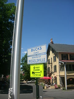
Riegelsville is a borough in Bucks County, Pennsylvania, United States. The population was 868 at the 2010 census. It is included in the Philadelphia-Wilmington-Camden Metropolitan Statistical Area, despite being so closely connected to the Lehigh Valley.

Lackawaxen Township, Pike County, Pennsylvania Township in Pennsylvania, United States

Lackawaxen Township is the largest and northernmost township in Pike County, Pennsylvania. The population was 4,994 at the 2010 census. The Delaware River, which marks the eastern boundary of the township, joins the Lackawaxen River at Lackawaxen Village. The housing communities Fawn Lake Forest and Masthope Mountain are in the township.

John A. Roebling German-American engineer

John Augustus Roebling was a German-born American civil engineer. He designed and built wire rope suspension bridges, in particular the Brooklyn Bridge, which has been designated as a National Historic Landmark and a National Historic Civil Engineering Landmark.

Union Canal (Pennsylvania) canal in Lebanon, Pennsylvania, United States of America

The Union Canal was a towpath canal that existed in southeastern Pennsylvania in the United States during the 19th century. First proposed in 1690 to connect Philadelphia with the Susquehanna River, it ran approximately 82 mi from Middletown on the Susquehanna below Harrisburg to Reading on the Schuylkill River.

Ohio and Erie Canal place in Ohio listed on National Register of Historic Places

The Ohio and Erie Canal was a canal constructed during the 1820s and early 1830s in Ohio. It connected Akron with the Cuyahoga River near its outlet on Lake Erie in Cleveland, and a few years later, with the Ohio River near Portsmouth. It also had connections to other canal systems in Pennsylvania.

United States National Register of Historic Places listings

The National Register of Historic Places in the United States is a register including buildings, sites, structures, districts, and objects. The Register automatically includes all National Historic Landmarks as well as all historic areas administered by the U.S. National Park Service. Since its introduction in 1966, more than 90,000 separate listings have been added to the register.

Roebling Bridge may refer to:

Roeblings Delaware Aqueduct

Roebling's Delaware Aqueduct, also known as the Roebling Bridge, is the oldest existing wire suspension bridge in the United States. It runs 535 feet over the Delaware River, from Minisink Ford, New York, to Lackawaxen, Pennsylvania. Opened in 1849 as an aqueduct connecting two parts of the Delaware & Hudson Canal (D&H), it has since been converted to carry automotive traffic and pedestrians.

National Register of Historic Places listings in Pennsylvania Wikimedia list article

This is a list of properties and districts listed on the National Register of Historic Places in Pennsylvania. As of 2015, there are over 3,000 listed sites in Pennsylvania. Sixty-six of the 67 counties in Pennsylvania have listings on the National Register; Cameron County is the only county without any sites listed.

Upper Delaware Scenic and Recreational River

The Upper Delaware Scenic and Recreational River is located near Narrowsburg, New York, and Lackawaxen, Pennsylvania, on the Delaware River. It includes parts of five counties along this section of the river: Delaware, Orange, and Sullivan in New York, and Pike and Wayne in Pennsylvania.

Barryville, New York Hamlet in New York

Barryville is a hamlet in Highland, Sullivan County, New York. Previously known as "The River," the hamlet was renamed for William T. Barry, postmaster general under President Andrew Jackson.

Lehigh Canal canal in Pennsylvania, United States of America

The Lehigh Canal or the Lehigh Navigation Canal is a navigable canal, beginning at the mouth of Nesquehoning Creek on the Lehigh River in Eastern Pennsylvania. It was built in two sections over a span of twenty years, beginning in 1818. The lower section spanned the distance between Easton, Pennsylvania and the town of Mauch Chunk, present-day Jim Thorpe, Pennsylvania. In Easton the canal met the Delaware and Morris Canals, with which goods could be brought further up the east coast. At its height, the Lehigh Canal was 72 miles (116 km) long.

Pennsylvania Canal former canal network in Pennsylvania

Pennsylvania Canal(or sometimes Pennsylvania Canal system) refers generally to a complex system of transportation infrastructure improvements including canals, dams, locks, tow paths, aqueducts, and viaducts. The Canal and Works were constructed and assembled over several decades beginning in 1824, the year of the first enabling act and budget items. It should be understood the first use of any railway in North America was the year 1826, so the newspapers and the Pennsylvania Assembly of 1824 applied the term then to the proposed Right of ways mainly for the canals of the Main Line of Public Works to be built across the southern part of Pennsylvania.

Wiconisco Canal canal in Pennsylvania, United States of America

The Wiconisco Canal was a 19th century transportation waterway, about 12 miles (19 km) long, in Dauphin County in the U.S. state of Pennsylvania. Running along the east bank of the Susquehanna River between Millersburg and Duncan's Island at the mouth of the Juniata River, the canal overcame about 42 feet (13 m) of vertical lift through the use of 7 locks.

Abbott Farm Historic District

The Abbott Farm Historic District is a National Historic Landmark archeological site in New Jersey. It is the largest known Middle Woodland village of its type on the East Coast of the United States. Significant evidence suggests that the Delaware River floodplain was occupied by Paleoindian people for a long period. It was inhabited between 500 BC and 500 AD. It has been a source of controversy and debate around early development.

Zane Grey Museum

The Zane Grey Museum in Lackawaxen Township, Pennsylvania, United States, is a former residence of the author Zane Grey and is now maintained as a museum and operated by the National Park Service (NPS). It is located on the upper Delaware River and is on the National Register of Historic Places. It contains many photographs, artworks, books, furnishings, and other objects of interest associated with Grey and his family.

Delaware and Hudson Canal Company Office building in Pennsylvania, United States

The D&H Canal Co. Office, now known as the Roebling Inn, is located on Scenic Drive in Lackawaxen, Pennsylvania, United States. It is a mid-19th century wooden house in the Greek Revival architectural style.

References