Liberty (village), New York

Last updated
Liberty, New York
Main Street in Liberty, New York.jpg
Looking north on Main Street
Sullivan County New York incorporated and unincorporated areas Liberty (village) highlighted.svg
Location of Liberty village in Sullivan County, New York
Coordinates: 41°48′N74°44′W / 41.800°N 74.733°W / 41.800; -74.733 Coordinates: 41°48′N74°44′W / 41.800°N 74.733°W / 41.800; -74.733
CountryUnited States
State New York
County Sullivan
Town Liberty
Incorporated1870
Area
[1]
  Total2.63 sq mi (6.80 km2)
  Land2.62 sq mi (6.79 km2)
  Water0.00 sq mi (0.01 km2)
Elevation
1,506 ft (459 m)
Population
 (2020)
  Total4,700
  Density1,793.21/sq mi (692.44/km2)
Time zone UTC-5 (Eastern (EST))
  Summer (DST) UTC-4 (EDT)
ZIP code
12754
Area code 845
FIPS code 36-42224
GNIS feature ID2390940
The village as shown on a postcard printed sometime from 1901 to 1907 PostcardLibertyNYBirdsEyeView19011907.jpg
The village as shown on a postcard printed sometime from 1901 to 1907

Liberty is a village in Sullivan County, New York, United States. The population was 4,700 at the 2020 census.

Contents

The Village of Liberty is centrally located in the Town of Liberty and is adjacent to New York Route 17.

History

While the Town of Liberty was incorporated in 1807, the Village of Liberty was not incorporated as a separate entity until 1870. [2]

The Munson Diner, Liberty Downtown Historic District, St. Paul's Evangelical Lutheran Church, and Town and Country Building are listed on the National Register of Historic Places. [3]

Geography

Liberty is located at 41°47′52″N74°44′34″W / 41.79778°N 74.74278°W / 41.79778; -74.74278 (41.797792, -74.742829). [4]

According to the United States Census Bureau, the village has a total area of 2.4 square miles (6.2 km2), all land.

Demographics

Historical population
CensusPop.
1880 478
1890 73453.6%
1900 1,760139.8%
1910 2,07217.7%
1920 2,45918.7%
1930 3,42739.4%
1940 3,78810.5%
1950 4,65823.0%
1960 4,7041.0%
1970 4,514−4.0%
1980 4,293−4.9%
1990 4,128−3.8%
2000 3,975−3.7%
2010 4,39210.5%
2020 4,7007.0%
U.S. Decennial Census [5]

As of the census [6] of 2000, there were 3,975 people, 1,646 households, and 893 families residing in the village. The population density was 1,660.3 people per square mile (642.2/km2). There were 2,071 housing units at an average density of 865.0 per square mile (334.6/km2). The racial makeup of the village was 76.58% White, 13.89% Black or African American, 0.30% Native American, 1.94% Asian, 5.38% from other races, and 1.91% from two or more races. Hispanic or Latino of any race were 14.21% of the population.

There were 1,646 households, out of which 30.1% had children under the age of 18 living with them, 32.8% were married couples living together, 16.5% had a female householder with no husband present, and 45.7% were non-families. 38.4% of all households were made up of individuals, and 17.2% had someone living alone who was 65 years of age or older. The average household size was 2.30 and the average family size was 3.09.

In the village, the population was spread out, with 25.5% under the age of 18, 7.3% from 18 to 24, 25.2% from 25 to 44, 23.4% from 45 to 64, and 18.6% who were 65 years of age or older. The median age was 40 years. For every 100 females, there were 84.0 males. For every 100 females age 18 and over, there were 79.7 males.

The median income for a household in the village was $27,903, and the median income for a family was $35,265. Males had a median income of $26,823 versus $27,813 for females. The per capita income for the village was $19,180. About 12.7% of families and 15.3% of the population were below the poverty line, including 13.5% of those under age 18 and 12.0% of those age 65 or over.

Notable person

See also

Related Research Articles

<span class="mw-page-title-main">Chuichu, Arizona</span> CDP in Pinal County, Arizona

Chuichu is a census-designated place (CDP) in Pinal County, Arizona, United States. The population was 308 at the 2020 census. It is the northernmost traditional village on the Tohono O'odham Nation reservation.

<span class="mw-page-title-main">Liberty, Illinois</span> Village in Illinois, United States

Liberty is a village in Adams County, Illinois, United States. The population was 543 at the 2020 census. It is part of the Quincy, IL–MO Micropolitan Statistical Area.

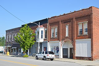
Garrett is a village in Douglas County, Illinois, United States. The population was 162 at the 2010 census.

<span class="mw-page-title-main">Alpha, Illinois</span> Village in Illinois, United States

Alpha is a village in Henry County, Illinois, United States. The population was 671 at the 2010 census, down from 726 in 2000.

<span class="mw-page-title-main">Valmeyer, Illinois</span> Village in Illinois, United States

Valmeyer is a village in Monroe County, Illinois, on the Mississippi River. The population was 1,263 at the 2010 United States Census.

<span class="mw-page-title-main">Poneto, Indiana</span> Town in Indiana, United States

Poneto is a town in Chester, Harrison and Liberty townships, Wells County, in the U.S. state of Indiana. The population was 166 at the 2010 census.

<span class="mw-page-title-main">Appleton, Maine</span> Town in the state of Maine, United States

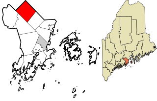
Appleton is a town in Knox County, Maine, United States. It is about 15 miles inland from Penobscot Bay and coastal towns such as Camden and Rockland, about 30 miles east of the state capital of Augusta, Maine. The population was 1,411 at the 2020 census.

<span class="mw-page-title-main">Jeffersonville, New York</span> Village in New York, United States

Jeffersonville is a village in Sullivan County, New York, United States. The population was 368 at the 2020 census. The name is derived indirectly from Thomas Jefferson.

<span class="mw-page-title-main">Roscoe, New York</span> CDP in New York, United States

Roscoe is a hamlet in Sullivan County, New York, United States. The population was 541 at the 2010 census.

<span class="mw-page-title-main">Fairview, Westchester County, New York</span> CDP in New York, United States

Fairview is a hamlet and a census-designated place (CDP) located in the town of Greenburgh, Westchester County, New York, United States. The population was 3,099 at the 2010 census. As of 2000, Fairview had the fourth-highest percentage of African-Americans in New York.

<span class="mw-page-title-main">Kirtland Hills, Ohio</span> Village in Ohio, United States

Kirtland Hills is a village in Lake County, Ohio, United States and a rural suburb of Cleveland. The population was 646 at the 2010 census.

<span class="mw-page-title-main">Wayne, Ohio</span> Village in Ohio, United States

Wayne is a village in Wood County, Ohio, United States. The population was 887 at the 2010 census.

<span class="mw-page-title-main">Eau Claire, Pennsylvania</span> Borough in Pennsylvania, United States

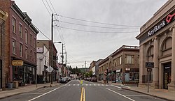
Eau Claire is a borough in Butler County, Pennsylvania, United States. The population was 316 at the 2010 census. The name means "Clear Water" in French, and the name is pronounced as though it were spelled "U'Clare".

<span class="mw-page-title-main">Liberty Township, Centre County, Pennsylvania</span> Township in Pennsylvania, United States

Liberty Township is a township in Centre County, Pennsylvania, United States. It is part of the State College, Pennsylvania Metropolitan Statistical Area. The population was 1,825 at the 2020 census, an increase over the figure of 2,118 tabulated in 2010. Part of Bald Eagle State Park is in Liberty Township.

<span class="mw-page-title-main">Liberty Township, Tioga County, Pennsylvania</span> Township in Pennsylvania, United States

Liberty Township is a township in Tioga County, Pennsylvania, United States. The population was 1,037 at the 2020 census.

<span class="mw-page-title-main">Morris Township, Tioga County, Pennsylvania</span> Township in Pennsylvania, United States

Morris Township is a township in Tioga County, Pennsylvania, United States. The population was 562 at the 2020 census.

<span class="mw-page-title-main">West Liberty, West Virginia</span> Town in West Virginia, United States

West Liberty is a town in Ohio County, West Virginia, United States. The population was 1,557 at the 2020 census. It is part of the Wheeling, West Virginia Metropolitan Statistical Area.

<span class="mw-page-title-main">Williamstown, Wisconsin</span> Town in Wisconsin, United States

Williamstown is a town in Dodge County, Wisconsin, United States. The population was 646 at the 2000 census.

<span class="mw-page-title-main">St. Joseph, Wisconsin</span> Town in Wisconsin, United States

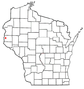
St. Joseph is a town in St. Croix County, Wisconsin, United States. The population was 3,842 at the 2010 census. The unincorporated communities of Burkhardt, and Houlton are located in the town.

<span class="mw-page-title-main">Middle Village, Wisconsin</span> CDP in Wisconsin, United States

Middle Village is a census-designated place (CDP), in the towns of Menominee and Red Springs, in Menominee and Shawano counties in the U.S. state of Wisconsin. It does not have any legal status as an incorporated municipality. The population was 290 at the 2020 census.

References

  1. "ArcGIS REST Services Directory". United States Census Bureau. Retrieved September 20, 2022.
  2. Child, Hamilton, Gazetteer and Business Directory for Sullivan County, NY for 1872-73 Archived 2010-04-05 at the Wayback Machine
  3. "National Register Information System". National Register of Historic Places . National Park Service. March 13, 2009.
  4. "US Gazetteer files: 2010, 2000, and 1990". United States Census Bureau. 2011-02-12. Retrieved 2011-04-23.
  5. "Census of Population and Housing". Census.gov. Retrieved June 4, 2015.
  6. "U.S. Census website". United States Census Bureau . Retrieved 2008-01-31.