Callicoon (CDP), New York

Last updated

Callicoon, New York
CDP
Downtown Callicoon from PA.JPG
Downtown Callicoon as seen from Pennsylvania across the Delaware River.
Sullivan County New York incorporated and unincorporated areas Callicoon (CDP) highlighted.svg
Location of Callicoon (CDP) in Sullivan County, New York
USA New York location map.svg
Red pog.svg
Callicoon, New York
Location within the state of New York
Coordinates: 41°45′57″N75°3′31″W / 41.76583°N 75.05861°W / 41.76583; -75.05861
CountryUnited States
State New York
County Sullivan
Area
[1]
  Total0.71 sq mi (1.84 km2)
  Land0.62 sq mi (1.61 km2)
  Water0.09 sq mi (0.23 km2)
Elevation
846 ft (258 m)
Population
 (2020)
  Total206
  Density331.19/sq mi (127.80/km2)
Time zone UTC-5 (Eastern (EST))
  Summer (DST) UTC-4 (EDT)
ZIP code
12723
Area code 845
FIPS code 36-11748
GNIS feature ID0945476

Callicoon is a hamlet and census-designated place in the Town of Delaware, Sullivan County, New York, United States. The population was 206 at the 2020 census. [2]

Contents

Callicoon is in the western part of the county in the Town of Delaware and along the Delaware River.

History

Erie train station at Callicoon as seen from Lower Main St Callicoon train station as seen from Lower Main St.jpg
Erie train station at Callicoon as seen from Lower Main St
Central Callicoon Central Callicoon.JPG
Central Callicoon
Route 97 in Callicoon Route 97 Callicoon.JPG
Route 97 in Callicoon
Callicoon Theater and other buildings in the business district. Callicoon Theater.JPG
Callicoon Theater and other buildings in the business district.
Grover M. Hermann Division of Catskill Regional Medical Center Callicoon hospital.JPG
Grover M. Hermann Division of Catskill Regional Medical Center

Callicoon got its name from Dutch hunters who settled the location in the 17th century. Because of the population of wild turkeys in the area, they named the community Kollikoonkill which translates into Wild Turkey Creek. In addition to animal abundance, the area was a source for lumber and a transport center with the Delaware River offering access to coastal cities to the south and east. In the 1840s, the Erie Railroad added to transportation by passing through along the banks of the Delaware River to link the Great Lakes with the East Coast. Because of the train station's vital central location, the community was renamed Callicoon Depot.

In 1888, a major fire destroyed much of Callicoon's business district. The town quickly rebuilt, but lost much of its architectural history prior to the late 19th century. The community's economy also became badly damaged when railroad travel gave way to the automobile. The last scheduled passenger train left Callicoon on November 27, 1966. By the late 1960s, tourism took over as the main industry as campgrounds and canoes drew a new generation of visitors. Campgrounds and canoe liveries, followed by bed and breakfast inns, drew a new generation of vacationers. The Villa Roma Resort and Conference Center also opened, increasing the number of vacationers to the area. Additionally, the Upper Delaware Scenic and Recreational River was created in 1978 to protect the land of the scenic valley, maintain quality of the Delaware River and enforce environmental sensitivity in the area. [3]

Geography and location

Callicoon is located on the east bank of the Delaware River, adjacent to the Catskill Mountains in the southern portion of Upstate New York. The community lies approximately 55 miles (89 km) northeast of Scranton, Pennsylvania, 65 miles (105 km) southeast of Binghamton, 115 miles (185 km) northwest of New York, and 120 miles (190 km) southwest of Albany.

Callicoon is located at 41°45′56″N75°3′31″W / 41.76556°N 75.05861°W / 41.76556; -75.05861 (41.765831, -75.058682). [4]

According to the United States Census Bureau, the CDP has a total area of 0.5 square mile (1.2 km2), of which, 0.4 square mile (1.0 km2) is land and 0.1 square mile (0.2 km2) (17.39%) is water.

Demographics

Historical population
CensusPop.Note
2020 206
U.S. Decennial Census [5]

As of the census [6] of 2000, there were 216 people, 94 households, and 61 families residing in the CDP. The population density was 565.1 inhabitants per square mile (218.2/km2). There were 106 housing units at an average density of 277.3 per square mile (107.1/km2). The racial makeup of the CDP was 91.67% White, 4.63% Black or African American, 3.24% Asian, and 0.46% from two or more races. Hispanic or Latino of any race were 6.02% of the population.

There were 94 households, out of which 28.7% had children under the age of 18 living with them, 43.6% were married couples living together, 17.0% had a female householder with no husband present, and 35.1% were non-families. 28.7% of all households were made up of individuals, and 12.8% had someone living alone who was 65 years of age or older. The average household size was 2.30 and the average family size was 2.79.

In the CDP, the population was spread out, with 23.6% under the age of 18, 5.6% from 18 to 24, 25.0% from 25 to 44, 29.2% from 45 to 64, and 16.7% who were 65 years of age or older. The median age was 41 years. For every 100 females, there were 98.2 males. For every 100 females age 18 and over, there were 94.1 males.

The median income for a household in the CDP was $33,162, and the median income for a family was $33,068. Males had a median income of $32,917 versus $19,375 for females. The per capita income for the CDP was $14,217. About 15.1% of families and 16.8% of the population were below the poverty line, including 25.8% of those under the age of eighteen and 16.7% of those 65 or over.

Major highways

Attractions and events

The Villa Roma Resort and Conference Center is a full resort hotel with tennis, cross-country skiing, lodging, and conference facilities. It is one of only a few resorts remaining in Sullivan County, a county once well known internationally for its massive resorts and entertainment venues.

Canoeing, rafting, camping, and hunting are major draws to the area. The Callicoon Canoe Regatta is held annually on a Sunday in early July. Dozens of competitors try their paddles on a journey navigating from the Callicoon Bridge to Skinner's Falls.

The Sullivan County Farmer's Market in Callicoon Creek Park on Sundays starting at 11:00 A.M. from Memorial day through November draws a big crowd as well. There is also a Holiday Market held in early December.

The Callicoon Business Association sponsors the Annual Tractor Parade, featuring more than 200 antique and modern tractors that travel down Main Street, in early June. The Callicoon Street Fair is held annually on the last Saturday of July, and once again, Main Street is closed down and turned over to a multitude of various vendors. The Street Fair features antiques, arts and crafts, homemade and hand-crafted items, food, and music.

Healthcare

Callicoon is home to the 25-bed Catskill Regional Medical Center, Grover M. Hermann Division, which serves the western portion of Sullivan County. A larger, more full-serviced hospital of the same name is located in Harris, between Monticello and Liberty.

Media

Sullivan County Democrat is a newspaper published bi-weekly covering news and events throughout the county. Its head office is located on Main Street in Callicoon.

Education

The Callicoon area was once home to Delaware Valley Central School. However, the school consolidated with schools in nearby Jeffersonville, New York and Narrowsburg, New York and closed. Narrowsburg's school also closed and Jeffersonville's school has become the sole elementary school for the region. A new junior-high/senior-high school building was built in centrally located Lake Huntington, New York. The recently formed Sullivan West Central School District still owns the school building in Callicoon, but has left it vacant.

Callicoon is the location of the Delaware Valley Job Corps Center, a job training facility located since 1979 in the former St. Joseph's Seraphic Seminary.

Delaware Free Library is a public library located on Main Street in the business district.

Related Research Articles

<span class="mw-page-title-main">Delaware County, New York</span> County in New York, United States

Delaware County is a county located in the US state of New York. As of the 2020 United States census, the population was 44,308. The county seat is Delhi. The county is named after the Delaware River, which was named in honor of Thomas West, 3rd Baron De La Warr, appointed governor of Virginia in 1609. The county is part of the Southern Tier region of the state.

<span class="mw-page-title-main">Sullivan County, New York</span> County in New York, United States

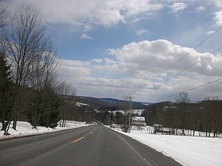
Sullivan County is a county in the U.S. state of New York. As of the 2020 census, the population was 78,624. The county seat is Monticello. The county's name honors Major General John Sullivan, who was labeled at the time as a hero in the American Revolutionary War in part due to his successful campaign against the Iroquois. The county is part of the Hudson Valley region of the state.

<span class="mw-page-title-main">Wailua, Kauai County, Hawaii</span> Census-designated place in Hawaii, United States

Wailua is a census-designated place (CDP) in Kauaʻi County, Hawaiʻi, United States. The population was 2,359 at the 2020 census, up from 2,083 at the 2000 census.
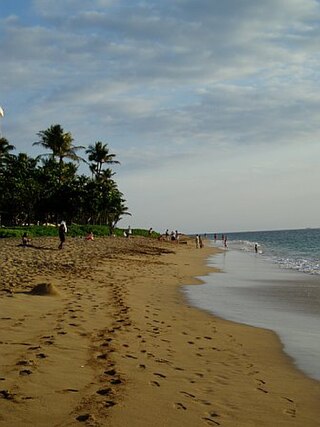
<span class="mw-page-title-main">Indian River, Michigan</span> Census-designated place & unincorporated community in Michigan, United States

Indian River is an unincorporated community and census-designated place (CDP) in Cheboygan County in the U.S. state of Michigan. The population was 1,950 at the 2020 census. The CDP is located in Tuscarora Township between Burt Lake and Mullett Lake.

<span class="mw-page-title-main">Cold Spring Harbor, New York</span> Hamlet and census-designated place in New York, United States

Cold Spring Harbor is a hamlet and census-designated place (CDP) in the Town of Huntington, in Suffolk County, on the North Shore of Long Island in New York. As of the 2010 United States census, the CDP population was 5,070.

<span class="mw-page-title-main">Cochecton, New York</span> Town in New York, United States

Cochecton is a town located in west-central Sullivan County, New York, United States. The population was 1,448 at the 2020 census. The name is derived from the Lenape word "cushetunk" meaning "place of red stone hills".

<span class="mw-page-title-main">Delaware, New York</span> Town in Sullivan County, New York, US

Delaware is a town in Sullivan County, New York, United States. The population was 2,203 at the 2020 census.

<span class="mw-page-title-main">Fremont, Sullivan County, New York</span> Town in New York, United States

Fremont is a town in Sullivan County, New York, United States. The population was 1,161 at the 2020 census.

<span class="mw-page-title-main">Highland, Sullivan County, New York</span> Town in New York, United States

Highland is a town in Sullivan County, New York, United States. The population was 2,196 at the 2020 census. The town's name denotes its location on elevated ground north of the Delaware River. The town is in the southwestern part of the county.

<span class="mw-page-title-main">Livingston Manor, New York</span> CDP and hamlet in New York, United States

Livingston Manor is a hamlet in Sullivan County, New York, United States. The population was 1,053 at the 2020 census.

<span class="mw-page-title-main">Monticello, New York</span> Village in Sullivan County, New York

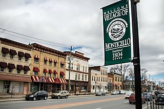
Monticello is a village located in Thompson, Sullivan County, within the Catskills region of New York, United States. It is the seat for the town of Thompson, and the county seat of Sullivan County. The population was 7,173 at the 2020 census. The village was named after the residence of Thomas Jefferson.

<span class="mw-page-title-main">Narrowsburg, New York</span> CDP in New York, United States

Narrowsburg is a hamlet in Sullivan County, New York, United States. The population was 379 at the 2020 census. Narrowsburg is in the western part of the Town of Tusten at the junction of Routes 52 and 97.

<span class="mw-page-title-main">Roscoe, New York</span> CDP in New York, United States

Roscoe is a hamlet in Sullivan County, New York, United States. The population was 497 at the 2020 census.

<span class="mw-page-title-main">Tusten, New York</span> Town in New York, United States

Tusten is a town in Sullivan County in the U.S. state of New York. The population was 1,405 at the 2020 census. The name is derived from Dr. Benjamin Tusten, a distinguished military leader killed when he refused to leave his troops at the Battle of Minisink.

<span class="mw-page-title-main">Kerhonkson, New York</span> Hamlet and CDP in New York, United States

Kerhonkson is a hamlet and census-designated place (CDP) in Ulster County, New York, United States. The population was 1,722 at the 2020 census.

<span class="mw-page-title-main">Folsom, Pennsylvania</span> Census-designated place in Pennsylvania, United States

Folsom is a census-designated place (CDP) in Delaware County, Pennsylvania, United States. It is part of Ridley Township. The population was 8,323 at the 2010 census.

<span class="mw-page-title-main">Mountain Top, Pennsylvania</span> Census-designated place in Pennsylvania, United States

Mountain Top is an unincorporated area and census-designated place (CDP) in Luzerne County, Pennsylvania, United States. As of the 2010 census, its population was 10,982.

<span class="mw-page-title-main">Teays Valley, West Virginia</span> Census-designated place in West Virginia, United States

Teays Valley is a census-designated place in Putnam County, West Virginia, United States. The population was 14,350 at the 2020 census. Located about 20 miles (32 km) west of Charleston and 30 miles (48 km) east of Huntington, it is part of the Huntington–Ashland metropolitan area.

<span class="mw-page-title-main">Pleasant Valley (CDP), New York</span> Census-designated place in New York, United States

Pleasant Valley is a census-designated place (CDP) in the southwestern part of the town of Pleasant Valley in Dutchess County, New York, United States. The population was 1,145 at the 2010 census. It is part of the Poughkeepsie–Newburgh–Middletown, NY Metropolitan Statistical Area as well as the larger New York–Newark–Bridgeport, NY-NJ-CT-PA Combined Statistical Area.

<span class="mw-page-title-main">Callicoon, New York</span> Town in New York, United States

Callicoon is a town in Sullivan County, New York, United States. The population was 2,989 at the 2020 census. The town is in the northwestern part of the county.

References

  1. "ArcGIS REST Services Directory". United States Census Bureau. Retrieved September 20, 2022.
  2. "Explore Census Data". data.census.gov. Retrieved October 10, 2022.
  3. History of the Callicoon Hamlet Archived 2012-11-04 at the Wayback Machine , Visit Callicoon on the Delaware, Copyright 2007, Accessed 8 December 2007.
  4. "US Gazetteer files: 2010, 2000, and 1990". United States Census Bureau. February 12, 2011. Retrieved April 23, 2011.
  5. "Census of Population and Housing". Census.gov. Retrieved June 4, 2016.
  6. "U.S. Census website". United States Census Bureau . Retrieved January 31, 2008.