Sullivan County is a county in the U.S. state of New York. As of the 2020 census, the population was 78,624. The county seat is Monticello. The county's name honors Major General John Sullivan, who was labeled at the time as a hero in the American Revolutionary War in part due to his successful campaign against the Iroquois.

Deerpark is a town in the western part of Orange County, New York, United States, and part of the New York metropolitan area. As of the 2020 Census, the population was at 7,509. The center of population of New York is located in Cuddebackville, a hamlet in Deerpark. Cuddebackville and Deerpark most prominently serve as the headquarters of both the global Falun Gong religious movement and the Shen Yun performance arts troupe, based at the Dragon Springs compound.

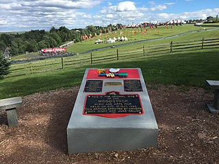
Bethel is a town in Sullivan County, New York, United States. The population was estimated at 3,959 in 2020. The town received worldwide attention after it served as the location of Woodstock in 1969, which was originally planned for Wallkill, New York, but was relocated to Bethel after Wallkill withdrew.

Fallsburg is a town in Sullivan County, New York, United States. The town is in the eastern part of the county. The population was 14,192 at the 2020 census. It is not to be confused with the hamlet of Fallsburg which bears a similar name and is within the town of Fallsburg.

Forestburgh is a town in Sullivan County, New York, United States. The population was 808 at the 2020 census. It is where the Neversink River enters the Neversink Gorge and flows over High Falls. The ZIP code of Forestburgh, New York is 12777.

Neversink is a town in Sullivan County, New York, United States. The population was 3,366 at the 2020 census.

Rockland is a town in the northern part of Sullivan County, New York, United States. At the 2020 census, the population was 3,290.

South Fallsburg is a hamlet and census-designated place in Sullivan County, New York, United States. South Fallsburg is located within the Town of Fallsburg at 41°42′59″N74°37′49″W.

Denning is an isolated town in Ulster County, New York, United States. The population was 493 at the 2020 census. The town is named after an early landowner, William Denning. Denning is located in the western part of the county, deep inside the Catskill Mountains. The location of the town in the Catskill State Park accounts in part for its low population.

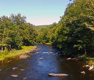
The Neversink River is a 55-mile-long (89 km) tributary of the Delaware River in southeastern New York in the United States. The name of the river comes from the corruption of an Algonquian language phrase meaning "mad river."
Bridgeville is a hamlet southeast of Monticello located in the southern Catskill Mountains in the Town of Thompson, County of Sullivan, and State of New York, United States. Bridgeville is located on the Neversink River on New York State Route 17, at an elevation of 1,081 feet (329 m). It has hilly terrain.

New York State Route 42 (NY 42) is a north–south, discontinuous state highway in the Catskill Mountains region of New York in the United States. The southernmost of the highway's two segments begins at an intersection with U.S. Route 6 (US 6) and US 209 in Port Jervis and ends at a junction with NY 55 near the Rondout Reservoir in Neversink. NY 42's northern segment runs from NY 28 in Shandaken to NY 23A in Lexington. The 41-mile (66 km) southern segment is located in Orange County and Sullivan County, while the 11-mile (18 km) northern segment is in Ulster County and Greene County.
White Lake is a hamlet in the town of Bethel, Sullivan County, New York, United States, on the southeastern shore of a lake of the same name. It was the closest community to the Woodstock Music and Art Fair in 1969.

Grahamsville is a hamlet at the junction of NY 42 and 55 in the Town of Neversink, in Sullivan County, New York, United States. It is near the western end of Rondout Reservoir, and is the southernmost community in the Catskill Park. It has the ZIP Code 12740 and the 985 telephone exchange in the 845 area code.

Loch Sheldrake is a hamlet and census-designated place (CDP) in the Town of Fallsburg, New York, United States, in Sullivan County. The zip code for Loch Sheldrake is 12759.
Hurleyville is a hamlet in the Town of Fallsburg in Sullivan County, New York, United States. The town lies along County Road 104 and was originally developed because it was on the main route between the Villages of Liberty and Monticello, New York. The zip code for Hurleyville is 12747.

Mountaindale is a hamlet in the town of Fallsburg in Sullivan County, New York, United States, situated at an altitude of 1,010 feet (310 m).
Kiamesha Lake is a hamlet in the town of Thompson, in east-central Sullivan County, New York, United States. The zip code for Kiamesha Lake is 12751.

B'nai Israel Synagogue, more commonly called The Woodbourne Shul, is an Orthodox Jewish congregation and historic, yet popular, synagogue, located at 457 NY State Route 52, in Woodbourne, in the Town of Fallsburg, in the Catskills region of Sullivan County, New York, in the United States. The congregation follows the Ashkenazi rite.
Fallsburg is a hamlet and census-designated place (CDP) in the town of Fallsburg in Sullivan County, New York, United States. It was first listed as a CDP prior to the 2020 census.


