Barryville, New York

Last updated
Barryville, New York
Hamlet and CDP
Hamlet of Barryville
Half way Brook 2018-11-01 624.jpg
NY 97 leading into Barryville
Country Flag of the United States.svg  United States
State Flag of New York.svg  New York
ZIP code
12719
Area code(s) Area Code 845 Exchange: 557
Website townofhighlandny.com

Barryville is a hamlet (and census-designated place) [1] in Highland, Sullivan County, New York, United States. Previously known as "The River," the hamlet was renamed for William T. Barry, postmaster general under President Andrew Jackson.

Contents

History

Barryville is a hamlet in the Town of Highland. The town was created by an act of the County Board of Supervisors on December 17, 1853. The Town of Lumberland was subdivided into the present day Towns of Lumberland, Highland and Tusten because the traveling distance for town meetings was too great. The town takes its name from highland ridges above the Delaware River. It was first inhabited by the Lenape and the trappers of Minisink and Mamakating. Colonial period hunters, trappers and lumbermen were drawn to Highland because of its streams and lakes, dense hardwood and conifer forests and wild game.

On July 22, 1779, the Upper Delaware's only major Revolutionary War battle was fought on the plateau above Minisink Ford. The battle was fought between the colonial militia of Goshen who suffered a devastating defeat against a group of Indians and Tories commanded by Mohawk Chieftain Joseph Brant. Highland was settled sometime after the War towards the turn of the century. The former hamlet of Lumberland Post Office, now Eldred, was established by 1814.

Delaware and Hudson Canal on the Delaware River in Barryville, NY. Provisions for educating the children of the inhabitants were made shortly after the first settlement in the town. The first store was opened in 1828 and the first tavern in 1830. Barryville developed with the construction of the Delaware and Hudson Canal in 1828. A blacksmith shop, a gristmill and a broomhandle factory were established in Barryville shortly thereafter. Later a glass factory opened which made molded glass. The town grew with the canal, providing a large maintenance area and supply depot for its canal worker. Between 1827 and 1898 the D&H Canal carried coal from the Moosic Mountains of Pennsylvania to the coal markets of New York City.

The later development of the Erie Railroad (now Norfolk Southern) helped in the development of the resort communities of Yulan and Highland Lake. By the early part of the twentieth century, the town's major industry was catering to the summer visitors who traveled to Highland via the railroad. When the Erie Railroad ceased to carry passengers and the automobile became the main mode of transportation, Highland slowly emerged as a second home community. Many persons began to purchase homes for weekend, vacation and summer use. Today there are a good number of people who now make Highland their primary residence while commuting to the New York metropolitan area to work.

Erie Railroad Many of the people who live in the town today are descendants of early settlers. The historical and architectural resources of Highland are rich and quite diverse in character. Among the most important are Locks No. 68, No. 69 and No. 70 of the D&H Canal, the Toll House, the Roebling Aqueduct, the Barryville Town Hall, the Barryville Congregational Church and Montoza Cemetery.

Locks No.'s 68, 69 and 70 of the Delaware and Hudson Canal (D&H Canal) are three of the 108 that once existed along the Canal. It was used primarily for the transportation of coal by barge from the Pennsylvania mountains to New York City and extended from Honesdale, Pennsylvania to Kingston, New York. The Canal was in active use from 1828 until 1898. The No. 68 and No. 70 locks are in good shape for historic interpretation. Lock No. 69 is thought to be largely intact, although its present owner filled it in 1981.

The Toll House stands on the New York side of the Roebling Bridge and was built somewhere between 1900 and 1905. This small, two-story structure served as the toll house for the Lackawaxen Bridge (Roebling Aqueduct) after the D&H Canal was closed. The Roebling Aqueduct is believed to be the oldest suspension bridge in America. Built by John Roebling, designer of the Brooklyn Bridge, it carried the D&H Canal across the river. After 50 years of use as an aqueduct, it became a highway bridge in 1898. The bridge consists of four spans, 132 feet to 142 feet, the widest to allow logging rafts to pass through. The bridge is a National Historic Landmark and a National Historic Civil Engineering Landmark. The National Park Service purchased and restored it several years ago.

The Barryville Town Hall is a relatively intact mid-nineteenth century schoolhouse of typical form. It is built in the Greek Revival style with stucco-covered rubble stone incised to resemble cut marble blocks. The building was used as a schoolhouse from 1867 to 1960. The town is seeking funds to restore the deteriorating exterior walls and foundation. The building has been converted for judicial use, including making it handicapped accessible.

The original Congregational Church in Barryville was organized in 1799, but the first church structure was not erected until 1835. Known as the Union Church, this structure burned in 1877 and was replaced by the present day structure in 1903. The church is no longer used for religious purposes, but its owner has adaptively reused it, preserving its historical integrity. A cemetery behind the church is the resting place for several Confederate soldiers killed on July 15, 1864 when a train carrying 833 prisoners of war to the federal prison at Elmira, NY collided with a coal train at Shohola. Nineteen guards and 51 soldiers were killed in the accident; some were buried along the tracks; the others were laid to rest in the Congregational Church Cemetery.

The Montoza Cemetery is located north of Barryville on Mail Road. It was laid out by John W. Johnson, a Barryville attorney who also wrote Reminiscences, an invaluable set of recollections of the early history of the area that has been published with the help of the town. Stones in the cemetery date back to 1861. Still older stones are found in the old Eldred Cemetery.

Other outstanding historical and architectural resources include the Eldred Congregational Church, St. Anthony's Cemetery, the Chapin Estate Stone Arch Waterfalls and the Minisink Battleground and Monument.

Camp Tel Yehudah Barryville is the home of Camp Tel Yehudah, a Young Judaea summer camp. The camp is home to campers from across the United States and a few places international locations including Israel and the United Kingdom.

Trivia

The Delaware River section between Narrowsburg and Barryville is considered a good spot for smallmouth fishing. [2]

Spring House was listed on the National Register of Historic Places in 2009. [3]

See also

Related Research Articles

The Erie Canal is a canal that traverses east–west through upstate New York, eastern United States, as part of the cross-state route of the New York State Canal System. It was built to create a navigable water route from the Atlantic Ocean to the Great Lakes Basin, originally stretching for 584 kilometres (363 mi) from the Hudson River at Albany to Lake Erie in Buffalo. Completed in 1825, it was the second-longest canal in the world and greatly enhanced the development and economy of many major cities of New York, including New York City, Albany, Syracuse, Rochester and Buffalo, as well as the United States. This was in part due to the new ease of transporting salt and other necessity goods, and industries that developed around those.

Pike County, Pennsylvania County in Pennsylvania, United States

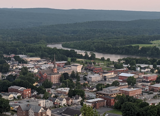
Pike County is a county located in the U.S. state of Pennsylvania. As of the 2020 census, the population was 58,535. Its county seat is Milford.

Port Jervis, New York City in New York, United States

Port Jervis is a city located at the confluence of the Neversink and Delaware rivers in western Orange County, New York, United States, north of the Delaware Water Gap. Its population was 8,775 at the 2020 census. The communities of Deerpark, Huguenot, Sparrowbush, and Greenville are adjacent to Port Jervis. Matamoras, Pennsylvania, is across the river and connected by bridge. Montague Township, New Jersey, borders here. The Tri-States Monument, marking the tripoint between New York, New Jersey, and Pennsylvania, lies at the southwestern corner of town.

Highland, Sullivan County, New York

Highland is a town in Sullivan County, New York, United States. The population was 2,530 at the 2010 census. The town's name denotes its location on elevated ground north of the Delaware River. The town is in the southwestern part of the county.

Lumberland, New York Town in New York, United States

Lumberland is a town in Sullivan County, New York, United States. The population was 2,468 at the 2010 census.

Lackawaxen Township, Pike County, Pennsylvania Township in Pennsylvania, United States

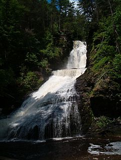
Lackawaxen Township is the largest and northernmost township in Pike County, Pennsylvania. The population was 4,994 at the 2010 census. The Delaware River, which marks the eastern boundary of the township, joins the Lackawaxen River at Lackawaxen Village. The housing communities Fawn Lake Forest and Masthope Mountain are in the township.

John A. Roebling German-American engineer

John Augustus Roebling was a German-born American civil engineer. He designed and built wire rope suspension bridges, in particular the Brooklyn Bridge, which has been designated as a National Historic Landmark and a National Historic Civil Engineering Landmark.

Delaware and Hudson Railway Railroad in the northeastern United States

The Delaware and Hudson Railway (D&H) is a railroad that operates in the Northeastern United States. In 1991, after more than 150 years as an independent railroad, the D&H was purchased by the Canadian Pacific Railway (CP). CP operates D&H under its subsidiary Soo Line Corporation which also operates Soo Line Railroad.

Main Line of Public Works United States historic place

The Main Line of Public Works was a package of legislation passed by the Commonwealth of Pennsylvania in 1826 to establish a means of transporting freight between Philadelphia and Pittsburgh. It funded the construction of various long-proposed canal and road projects, mostly in southern Pennsylvania, that became a canal system and later added railroads. Built between 1826 and 1834, it established the Pennsylvania Canal System, the Allegheny Portage Railroad, and the Pennsylvania Canal System.

New York State Route 97 (NY 97) is a 70.53-mile-long (113.51 km) north–south scenic route in southern New York in the United States. It runs from U.S. Route 6 (US 6) and US 209 in Port Jervis to NY 17 in Hancock. Its most famous feature is the Hawk's Nest, a tightly winding section of the road along the Delaware River, located a few miles north of Port Jervis. NY 97 intersects NY 52 in Narrowsburg and indirectly connects to three Pennsylvania state highways due to its proximity to the state line.

Delaware and Hudson Canal Former canal in New York and Pennsylvania, United States

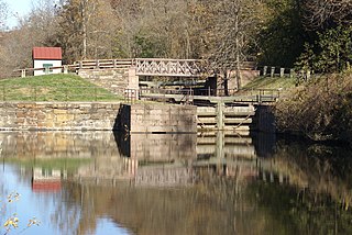
The Delaware and Hudson Canal was the first venture of the Delaware and Hudson Canal Company, which would later build the Delaware and Hudson Railway. Between 1828 and 1899, the canal's barges carried anthracite coal from the mines of Northeastern Pennsylvania to the Hudson River and thence to market in New York City.

Roeblings Delaware Aqueduct

Roebling's Delaware Aqueduct, also known as the Roebling Bridge, is the oldest existing wire suspension bridge in the United States. It runs 535 feet over the Delaware River, from Minisink Ford, New York, to Lackawaxen, Pennsylvania. Opened in 1849 as an aqueduct connecting two parts of the Delaware & Hudson Canal (D&H), it has since been converted to carry automotive traffic and pedestrians.

Minisink Ford is a hamlet on the Delaware River, fifteen miles northwest of Port Jervis. It is in the town of Highland, Sullivan County, New York, United States.

Schuylkill Canal

The Schuylkill Canal, or Schuylkill Navigation, was a system of interconnected canals and slack-water pools along the Schuylkill River in the U.S. state of Pennsylvania, built as a commercial waterway in the early 19th-century. Chartered in 1815, the navigation opened in 1825 to provide transportation and water power. At the time, the river was the least expensive and most efficient method of transporting bulk cargo, and the eastern seaboard cities of the U.S. were experiencing an energy crisis due to deforestation. It fostered the mining of anthracite coal as the major source of industry between Pottsville and eastern markets. Along the tow-paths, mules pulled barges of coal from Port Carbon through the water gaps to Pottsville; locally to the port and markets of Philadelphia; and some then by ship or through additional New Jersey waterways, to New York City markets.

The Upper Delaware Scenic and Recreational River stretches along approximately 73.4 miles (118.1 km) of the Delaware River from Hancock, New York to Sparrowbush, New York on the border between New York and Pennsylvania. It includes parts of five counties along this section of the river: Delaware County, Orange County, and Sullivan County in New York and Pike County and Wayne County in Pennsylvania.

Lehigh Canal United States historic place

The Lehigh Canal or the Lehigh Navigation Canal is a navigable canal, beginning at the mouth of Nesquehoning Creek on the Lehigh River in eastern Pennsylvania in the United States. It was built in two sections over a span of twenty years, beginning in 1818. The lower section spanned the distance between Easton, Pennsylvania and present-day Jim Thorpe, Pennsylvania. In Easton, the canal met the Delaware and Morris Canals, which allowed goods to be transported further up the east coast. At its height, the Lehigh Canal was 72 miles (116 km) long.

Leiper Canal

Early in the 19th century, the Leiper Canal built in 1828-29 during the middle of the American canal age ran about 3 miles (5 km) along Crum Creek in Delaware County to its mouth in Eastern Pennsylvania's Delaware Valley carrying its owner‘s quarried products to docks on the Delaware River tidewater until 1852.

High Falls Historic District United States historic place

The High Falls Historic District corresponds roughly to the downtown section of the hamlet of that name in Marbletown, New York, United States. It is a 21-acre (8.5 ha) area around the intersection of state highway NY 213, Main Street, Mohonk Road (Ulster County Route 6A0 and Bruceville Road just south of Rondout Creek.

Pond Eddy Bridge Petit truss bridge in Pond Eddy, US

The Pond Eddy Bridge is a petit truss bridge spanning the Delaware River between the hamlet of Pond Eddy in Lumberland, New York and the settlement informally called Pond Eddy in Shohola Township, Pennsylvania. It is accessible from NY 97 in Lumberland on the New York side and two dead-end local roads, Flagstone Road and Rosa Road on the Pennsylvania side. The bridge was built in 1903 by the Oswego Bridge Company to replace an old suspension bridge that had washed away in a flood earlier in the year. It connected the bluestone quarries in Pennsylvania to New York.

Barryville–Shohola Bridge Road bridge

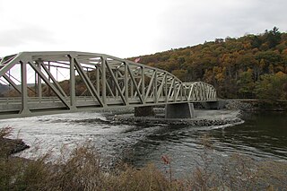
The Barryville–Shohola Bridge is the fifth generation of bridges constructed over the Delaware River at the communities of Shohola Township, Pennsylvania and Barryville, New York. The bridge serves both communities, with two major state legislative highways, Pennsylvania Traffic Route 434 and New York State Touring Route 55. The bridge itself is 812 feet (247 m) long and is 23 feet (7.0 m) wide, using four total spans across the river. It is maintained by the NY–PA Joint Interstate Bridge Commission, which is jointly owned by the states of New York and Pennsylvania.

References

  1. "State of New York Census Designated Places - Current/BAS20 - Data as of January 1, 2019". tigerweb.geo.census.gov. Retrieved 2020-02-25.
  2. This is true, ive been there Weamer, Paul (2007), Fly-Fishing Guide to the Upper Delaware River, Stackpole Books, p. 136, ISBN   978-0-8117-3408-0
  3. "National Register of Historic Places". WEEKLY LIST OF ACTIONS TAKEN ON PROPERTIES: 11/30/09 THROUGH 12/04/09. National Park Service. 2009-12-11.

Coordinates: 41°28′39″N74°54′40″W / 41.47750°N 74.91111°W / 41.47750; -74.91111