Wurtsboro, New York

Last updated

Wurtsboro
Wurtsboro Ridge.jpg
Sullivan County New York incorporated and unincorporated areas Wurtsboro highlighted.svg
Location of Wurtsboro in Sullivan County, New York
USA New York location map.svg
Red pog.svg
Wurtsboro
Location within the state of New York
Coordinates: 41°34′34″N74°29′08″W / 41.57611°N 74.48556°W / 41.57611; -74.48556
CountryUnited States
State New York
County Sullivan
Town Mamakating
Area
[1]
  Total1.25 sq mi (3.24 km2)
  Land1.25 sq mi (3.24 km2)
  Water0.00 sq mi (0.00 km2)
Elevation
[2]
564 ft (172 m)
Population
 (2020)
  Total1,124
  Density899.92/sq mi (347.41/km2)
Time zone UTC-5 (Eastern (EST))
  Summer (DST) UTC-4 (EDT)
ZIP code
12790
Area code 845
FIPS code 36-83272 [3]
GNIS feature ID2391227 [2]

Wurtsboro is a village located on U.S. Route 209 in the town of Mamakating in Sullivan County, New York, United States, near its junction with New York State Route 17 (which is being upgraded to interstate standards and will be renumbered as interstate 86). The population was 1,124 at the 2020 census. Since 1927 the area has been served by Wurtsboro-Sullivan County Airport.

Contents

History

Before Europeans, Wurtsboro was inhabited by Native Americans known as the Leni Lenape. Called Delaware by the Europeans, the Leni Lenape are known to other tribes, in their tongues, as "the old people" and are considered to be one of the oldest tribes in North America. Many anthropologists believe the Leni Lenape are the ancestors of the original people who crossed the Bering Strait to first populate North American. Within the Leni Lenape, different villages dotted the valleys between the Delaware and Hudson rivers. The group that resided in the Wurtsboro area was known as the Mamacottin.

As the Dutch settled along the Hudson and searched inland for furs and minerals, they engineered and built the oldest road in America. This roadway, little more than a cart path along the trails of the Leni Lenape, became known as the Old Mine Road. Present day US Rte. 209 follows much of the original course. It is thought that these Dutch settlers were the first to name the area Mamakating.

As other Europeans settled the area, the treaties and land grants for a great deal of the northeast were benchmarked from the Hardenburgh tract. That survey benchmark, still annotated and utilized, can be found in the village near Rte. 209.

The original name for the village of Wurtsboro was Rome. It is said that when the ‘yankees’ obtained a foothold in the hollow (Mamakating valley), they counted all the mountain peaks they could see and with an ambitious view, called the place Rome. This name was retained until as late as 1812. That same year, the area's first church was built. This Dutch Reformed church was named the "Church of Rome." Somewhat later the town was renamed Wurtsborough, which evolved to Wurtsboro.

During the early industrial revolution, much of the nation's bituminous coal needs were supplied by England. During the War of 1812, a fuel shortage arose when a British blockade cut off America's coal supply. Interest turned to anthracite coal, known then as stone coal. Anthracite was native to Pennsylvania, but lack of adequate transportation was a deterrent. Three Wurts brothers (Maurice Wurts was the most prominent), then Philadelphia dry goods store owners, capitalized on this problem by forming a company to construct a 108-mile canal from Honesdale, Pennsylvania to Kingston, New York, the Delaware and Hudson Canal. On July 13, 1825, New York City Mayor (and company investor) Philip Hone used a golden spade to turn the first shovelful of earth during the canal's groundbreaking ceremony, in the village. With the advent of the canal, products such as coal, lumber, livestock, and other staples were shipped through the area on their way to Albany and New York City. In those days, it was a practice of the D&H Canal Co. to rename communities along the canal for their favored officers. Names such as Honesdale, Port Jervis, Hawley, and Wurtsboro were so named.

As steam replaced horse power, the railroads replaced the canals. While the canal operated until its closure in 1898, the D&H Railroad was in fact a reorganization of the original canal company. In many sections, the railroad bed (now abandoned) parallels the canal. Both can be easily seen by visiting the D&H Canal Linear Park, which is a scenic walkway along the canal towpath from Wurtsboro to Summitville.

The village of Wurtsboro was originally confined to the berm of the canal. Several existing businesses were active at that time. Notable examples include Danny's, built in 1814 for the purpose of serving food and providing lodging; and the Canal Towne Emporium, better known in the canal days as Fulton & Holmes’ General Store, selling many items that were delivered by canal barge. Over time, the village gradually extended westward and merged with the old village of Mamakating. In 1830 the name of the post office was changed from Mamakating to Wurtsborough, with Lyman O’Dell (known as the village poet and essayist) acting as the first postmaster.

Another economic impact for the area in those early days was derived from the tanning industry that developed here. Hemlock bark was used to tan hides and it was in plentiful supply. In fact, over 80% of all leather goods used by the Union Army during the Civil War were processed in Sullivan county tanning vats. The industry waned as the hemlock in the area was over-forested (accounting for the scarcity today) and synthetic tannic acid was developed. In the late 1800s the Ontario & Western Railroad laid down its tracks on the eastern end of the village. Like the canal, it served to carry merchandise as well as passengers to the area. The O&W was a primary player in the tourism boom during the late 1800s into the 20th century, as it allowed thousands of New York residents to escape the heat of the city and relax in the clean Catskill mountain air. Eventually, just as the railroads replaced the canals, the interstate highway system replaced the railroads.

Geography

According to the United States Census Bureau, the village has a total area of 1.3 square miles (3.4 km2), all land.

The Long Path, a hiking trail, goes through Wurtsboro.

The Mamakating Park Historic District and Masten-Quinn House are listed on the National Register of Historic Places. [4]

Demographics

Historical population
CensusPop.Note
1870 797
1880 538−32.5%
1890 490−8.9%
1900 450−8.2%
1910 4786.2%
1920 362−24.3%
1930 42316.9%
1940 48715.1%
1950 62829.0%
1960 6554.3%
1970 73211.8%
1980 1,12854.1%
1990 1,048−7.1%
2000 1,23417.7%
2010 1,2461.0%
2020 1,124−9.8%
U.S. Decennial Census [5]

As of the census [3] of 2000, there were 1,234 people, four hundred seventy nine households, and 330 families residing in the village. The population density was 975.5 inhabitants per square mile (376.6/km2). There were 542 housing units at an average density of 428.5 per square mile (165.4/km2). The racial makeup of the village was 93.68% white, 1.86% African American, 0.81% Asian, 1.62% from other races, and 2.03% from two or more races. Hispanic of any race were 4.62% of the population.

There were 479 households, out of which 39.5% had children under the age of 18 living with them, 50.3% were married couples living together, 13.2% had a female householder with no husband present, and 31.1% were non-families. 27.3% of all households were made up of individuals, and 9.6% had someone living alone who was 65 years of age or older. The average household size was 2.58 and the average family size was 3.15.

In the village, the population was spread out, with 30.2% under the age of 18, 6.8% from 18 to 24, 30.1% from 25 to 44, 22.5% from 45 to 64, and 10.3% who were 65 years of age or older. The median age was 35 years. For every 100 females, there were 92.5 males. For every 100 females age 18 and over, there were 88.4 males.

The median income for a household in the village was $38,500, and the median income for a family was $46,359. Males had a median income of $40,385 versus $25,060 for females. The per capita income for the village was $16,698. About 9.7% of families and 10.9% of the population were below the poverty line, including 11.5% of those under age 18 and 1.5% of those age 65 or over.

Related Research Articles

<span class="mw-page-title-main">Pike County, Pennsylvania</span> County in Pennsylvania, United States

Pike County is a county in the Commonwealth of Pennsylvania. As of the 2020 census, the population was 58,535. Its county seat is Milford. The county is part of the Northeast Pennsylvania region of the state.

<span class="mw-page-title-main">Port Jervis, New York</span> City in New York, United States

Port Jervis is a city located at the confluence of the Neversink and Delaware rivers in western Orange County, New York, United States, north of the Delaware Water Gap. Its population was 8,775 at the 2020 census. The communities of Deerpark, Huguenot, Sparrowbush, and Greenville are adjacent to Port Jervis. Matamoras, Pennsylvania, is across the river and connected by the Mid-Delaware Bridge. Montague Township, New Jersey, also borders the city. The Tri-States Monument, marking the tripoint between New York, New Jersey, and Pennsylvania, lies at the southwestern corner of the city.

<span class="mw-page-title-main">Lumberland, New York</span> Town in New York, United States

Lumberland is a town in Sullivan County, New York, United States. The population was 2,243 at the 2020 census.

<span class="mw-page-title-main">Mamakating, New York</span> Town in New York, United States

Mamakating is a town in the southeastern section of Sullivan County, New York, United States. The population was 12,655 at the 2020 census.

<span class="mw-page-title-main">Napanoch, New York</span> CDP in New York, United States

Napanoch is a hamlet in Town of Wawarsing, in Ulster County, New York, United States. It is at the junction of routes 209 and 55. The population was 1,131 at the 2020 census. Napanoch is on the Shawangunk Ridge National Scenic Byway, and is part of the Hudson River Valley National Heritage Area.

<span class="mw-page-title-main">Phoenicia, New York</span> CDP and hamlet in New York, United States

Phoenicia is a hamlet of Shandaken in Ulster County, New York, United States. The population was 268 at the 2020 census, making it the second highest populated community in the town. The village center is located just off Route 28 at its junction with Route 214 and is nestled at the base of three peaks, Mount Tremper, Romer Mountain, and Sheridan Mountain. The community sits at the confluence of the Esopus Creek and Stony Clove Creek. A popular getaway for New Yorkers, the hamlet has frequented many tourism guides as among the best vacation towns in the greater New York City area.

<span class="mw-page-title-main">Jim Thorpe, Pennsylvania</span> Borough and county seat of Carbon County, Pennsylvania

Jim Thorpe is a borough and the county seat of Carbon County in the U.S. state of Pennsylvania. It is part of Northeastern Pennsylvania. It is historically known as the burial site of Native American sports legend Jim Thorpe.

<span class="mw-page-title-main">Toughkenamon, Pennsylvania</span> Census-designated place in Pennsylvania, United States

Toughkenamon is a census-designated place (CDP) in New Garden Township, Chester County, Pennsylvania, United States. The population was 1,492 at the 2010 census.

<span class="mw-page-title-main">Carbondale, Pennsylvania</span> City in Pennsylvania, United States

Carbondale is a city in Lackawanna County, Pennsylvania, United States. Carbondale is located approximately 15 miles due northeast of the city of Scranton in Northeastern Pennsylvania. The population was 8,828 at the 2020 census.

<span class="mw-page-title-main">Duryea, Pennsylvania</span> Borough in Pennsylvania, United States

Duryea is a borough in the Greater Pittston area of Luzerne County, Pennsylvania, United States, 9 miles (14 km) south of Scranton. The Susquehanna River marks Duryea's western boundary and the Lackawanna River flows through Duryea. It was incorporated as a borough in 1901, and had a notable switching rail yard, the Duryea yard, connecting the central Wyoming Valley to destinations in lower New York and down-state Pennsylvania. Coal mining and silk manufacturing were the chief industries in Duryea's early years. The population was 5,032 at the 2020 census.

<span class="mw-page-title-main">Plains Township, Pennsylvania</span> Township in Pennsylvania, United States

Plains Township is a township in Luzerne County, Pennsylvania, United States. The population was 9,816 at the 2020 census. The municipality is the birthplace of Chicago White Sox hall of famer Ed Walsh and John J. Yeosock, a United States Army general who commanded the 3rd U.S. Army during Operation Desert Shield and Operation Desert Storm. Mohegan Pennsylvania is a casino in Plains Township.

<span class="mw-page-title-main">White Haven, Pennsylvania</span> Borough in Pennsylvania, United States

White Haven is a borough in Luzerne County, Pennsylvania, United States. It is located along the Lehigh River. The population was 1,163 at the 2020 census.

<span class="mw-page-title-main">Shamokin, Pennsylvania</span> City in Pennsylvania, United States

Shamokin is a city in Northumberland County, Pennsylvania, United States. Surrounded by Coal Township at the western edge of the Anthracite Coal Region in central Pennsylvania's Susquehanna River Valley, the city was named after a Saponi Indian village, Schahamokink. At the 2020 United States census, the population was 6,942.

<span class="mw-page-title-main">Lackawaxen Township, Pike County, Pennsylvania</span> Township in Pennsylvania, United States

Lackawaxen Township is the largest and northernmost township in Pike County, Pennsylvania, United States. The population was 5,066 at the 2020 census. The Delaware River, which marks the eastern boundary of the township, joins the Lackawaxen River at Lackawaxen Village. The housing communities Fawn Lake Forest and Masthope Mountain are in the township.

<span class="mw-page-title-main">Tamaqua, Pennsylvania</span> Borough in Pennsylvania, United States

Tamaqua is a borough in eastern Schuylkill County in the Coal Region of Pennsylvania, United States. It had a population of 6,934 as of the 2020 U.S. census.

<span class="mw-page-title-main">Honesdale, Pennsylvania</span> Borough in Pennsylvania, United States

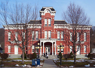
Honesdale is a borough in and the county seat of Wayne County, Pennsylvania, United States. The borough's population was 4,458 at the time of the 2020 census.

<span class="mw-page-title-main">Schuylkill River</span> River in eastern Pennsylvania, United States

The Schuylkill River is a river in eastern Pennsylvania. It flows for 135 miles (217 km) from Pottsville southeast to Philadelphia, where it joins the Delaware River as one of its largest tributaries.

<span class="mw-page-title-main">Delaware and Hudson Railway</span> Railroad in the northeastern United States

The Delaware and Hudson Railway (D&H) is a railroad that operates in the Northeastern United States. In 1991, after more than 150 years as an independent railroad, the D&H was purchased by the Canadian Pacific Railway (CP). CP operated D&H under its subsidiary Soo Line Corporation, which also operates Soo Line Railroad.

<span class="mw-page-title-main">Delaware and Hudson Canal</span> Former canal in New York and Pennsylvania, United States

The Delaware and Hudson Canal was the first venture of the Delaware and Hudson Canal Company, which would later build the Delaware and Hudson Railway. Between 1828 and 1899, the canal's barges carried anthracite coal from the mines of northeastern Pennsylvania to the Hudson River and thence to market in New York City.

<span class="mw-page-title-main">Delaware and Lehigh National Heritage Corridor</span> United States National Heritage Area in Pennsylvania

The Delaware & Lehigh Canal National and State Heritage Corridor (D&L) is a 165-mile (266 km) National Heritage Area in eastern Pennsylvania in the United States. It stretches from north to south, across five counties and over one hundred municipalities. It follows the historic routes of the Lehigh and Susquehanna Railroad, Lehigh Valley Railroad, the Lehigh Navigation, Lehigh Canal, and the Delaware Canal, from Bristol northeast of Philadelphia to Wilkes-Barre in the northeastern part of the state.

References

  1. "ArcGIS REST Services Directory". United States Census Bureau. Retrieved September 20, 2022.
  2. 1 2 U.S. Geological Survey Geographic Names Information System: Wurtsboro, New York
  3. 1 2 "U.S. Census website". United States Census Bureau . Retrieved January 31, 2008.
  4. "National Register Information System". National Register of Historic Places . National Park Service. March 13, 2009.
  5. "Census of Population and Housing". Census.gov. Retrieved June 4, 2015.