Livingston Manor, New York

Last updated

Livingston Manor, New York
CDP and hamlet
Downtown Livingston Manor, NY.jpg
View north along Main Street
Etymology: From Livingston family
Livingston-manor-ny.gif
U.S. Census map of Livingston Manor
USA New York location map.svg
Red pog.svg
Livingston Manor, New York
Usa edcp location map.svg
Red pog.svg
Livingston Manor, New York
Coordinates: 41°53′48.2″N74°49′34.2″W / 41.896722°N 74.826167°W / 41.896722; -74.826167
CountryUnited States
State New York
Region Catskills
County Sullivan
Area
[1]
  Total3.26 sq mi (8.43 km2)
  Land3.25 sq mi (8.40 km2)
  Water0.01 sq mi (0.03 km2)
Elevation
1,401 ft (427 m)
Population
 (2020)
  Total1,053
  Density324.50/sq mi (125.31/km2)
Time zone UTC-5 (Eastern (EST))
  Summer (DST) UTC-4 (EDT)
ZIP Code
12758
Area code 845
Exchange 439
FIPS code 36-42928
GNIS feature ID0955750
Website www.livingstonmanor.org

Livingston Manor is a hamlet (and a census-designated place) in Sullivan County, New York, United States. The population was 1,053 at the 2020 census.

Contents

Livingston Manor is located in the southern part of the town of Rockland. New York State Route 17 runs by it.

History

Main Street, from a postcard mailed in 1909 PostcardLivingstonManorNYMainStreet1909.jpg
Main Street, from a postcard mailed in 1909

In the late 19th century, this community renamed itself as Livingston Manor, after descendants of the prominent Livingston family who had a house there. But it was not part of the original manor, a huge estate granted by the English Crown about 60 miles (97 km) east in present-day Dutchess and Columbia counties that extended on both sides of the Hudson River. In the early 18th century, the original manor was the site of work camps along the Hudson, where Palatine German refugees worked off their passage to New York paid by the Crown. They produced timber and supplies for the English navy. Later they were allowed to settle in the Schoharie and Mohawk valleys.

The Sullivan County community was part of the Hardenbergh patent in 1716, which included much of the Catskill Mountains.

In 1750, Robert Livingston bought 95,000 acres (380 km2) in this area, shortly after becoming the third (and final) Lord of the Manor of Livingston Manor. He sold or leased most of the land by 1780. Robert's third son, John Robert Livingston (1775–1851), [2] deeded 8,441 acres (34.16 km2) to his nephew, Dr. Edward R. Livingston, in 1822 around the area then called Purvis, New York. Edward Livingston died in 1864.

In 1880, the New York, Ontario and Western Railway reached Livingston Manor. Many of its premier trains, such as the Livingston Manor Express, ended there. Passenger service ended in early September, 1953, and the railroad was abandoned on March 30, 1957.

Purvis residents in 1882 chose the new name of Livingston Manor. [3] Edward Livingston's residence, according to a sign in the village, was on a site now occupied by the village firehouse. [3] Another town source says that it was on a site later developed as the Rockland, New York Town Hall. [4]

In the 1930s, a Livingston descendant arrived in Livingston Manor claiming title to his ancestral land, which had previously been held by tenants under lease. He won his case in court. The people whose ancestors had been tenants had to purchase the property they had been living on for years.

Other early settlers were the Benton family. Their immigrant ancestors had come from Essex, England, in the mid-17th century, settling in Guilford, Connecticut. Records show some of their descendants migrated to in Sullivan County in the late 18th century from Connecticut, purchasing a large tract of land in what is now known as the Township of Liberty. They were likely Scots-Irish in ancestry. They took on many jobs in Sullivan County. Other families who acquired land and settled in the surrounding area were the Bascoms, Stewarts, Wests, Harringtons, Williams, Cochrans, Motts, Kimballs, Darbees, Sherwoods, Woodards, Barnharts, and Joselyns. Some descendants of these families still reside in the area.

In the late 19th and early 20th centuries, the village attracted immigrants from eastern Europe. Ashkenazy Jewish immigrants founded the Agudas Achim Synagogue. It was listed on the National Register of Historic Places in 1998. [5]

Fly fishing in the United States

The area claims to be the "birthplace of fly-fishing in the United States" [6] largely because of trout fishing on the 27-mile (43 km)-long Willowemoc Creek. It flows between the village and Roscoe, where it intersects the Beaver Kill. The Catskill Fly Fishing Center and Museum is on the northern edge of the town on the Willowemoc Creek.

Willowemoc Creek as it enters Livingston Manor WillowemocLM.JPG
Willowemoc Creek as it enters Livingston Manor

Today fish stocks in the Catskills are managed by state wildlife agents. All of the stocked fish (1 million pounds each year) for the Catskills, as well all the reservoirs in the New York City water supply, are bred at the Catskill Fish Hatchery just northeast of Livingston Manor in DeBruce, New York. [7]

Since 2004, the community has sponsored an annual Trout Parade (organized by the Catskill Art Society and the Chamber of Commerce). It has been compared to the Mermaid Parade. [6]

Education

Livingston Manor Central School District manages the public schools in the township. They consist of Livingston Manor Central School (middle and high school) and Livingston Manor Elementary School. Livingston Manor's Varsity softball team won the Class D Section 9 State title in 2010 and 2011. The Boys Varsity baseball team won the Class D Section 9 State title in 2011. [8]

Geography

Aerial view of Livingston Manor (at center) and environs roughly from the southwest (2013). Shandelee Lake at lower left. Aerial - Livingston Manor, NY from SW 01 - white balanced & 50pct equalized (9637966501).jpg
Aerial view of Livingston Manor (at center) and environs roughly from the southwest (2013). Shandelee Lake at lower left.

Livingston Manor is located at 41°53′46″N74°49′38″W / 41.89611°N 74.82722°W / 41.89611; -74.82722 (41.896061, -74.827348). [9] According to the United States Census Bureau, the CDP has a total area of 3.1 square miles (8.0 km2), all land.

Downtown

The downtown of Livingston Manor, mostly along Main Street, has several restaurants, a large grocery store, several art and antique shops. It is the scene of an annual "trout parade" in June that draws marching bands, fire trucks and other local amusements. The Catskill Art Society runs a non-profit multi-arts venue on Main Street, the CAS Arts Center, which offers exhibits on view in their galleries and fine arts classes to the community. [10]

Flood problems

Numerous times in recent history, heavy rain storms significantly increased the flow of the Willowemoc Creek causing flooding of main street and other low lying areas of the hamlet.

Demographics

Historical population
CensusPop.Note
2000 1,355
2010 1,221−9.9%
2020 1,053−13.8%
U.S. Decennial Census [11]

As of the census [12] of 2000, there were 1,355 people, 515 households, and 330 families residing in the CDP. The population density was 437.6 inhabitants per square mile (169.0/km2). There were 619 housing units at an average density of 199.9/mi2 (77.1/km2). The racial makeup of the CDP was 85.39% White, 6.20% African American, 0.15% Native American, 0.96% Asian, 5.09% from other races, and 2.21% from two or more races. Hispanic or Latino of any race were 11.81% of the population.

There were 515 households, out of which 33.8% had children under the age of 18 living with them, 41.4% were married couples living together, 16.1% had a female householder with no husband present, and 35.9% were non-families. 28.5% of all households were made up of individuals, and 11.8% had someone living alone who was 65 years of age or older. The average household size was 2.62 and the average family size was 3.21.

In the CDP, the population was spread out, with 31.8% under the age of 18, 7.4% from 18 to 24, 26.0% from 25 to 44, 21.7% from 45 to 64, and 13.1% who were 65 years of age or older. The median age was 35 years. For every 100 females, there were 94.1 males. For every 100 females age 18 and over, there were 90.5 males.

The median income for a household in the CDP was $27,159, and the median income for a family was $29,167. Males had a median income of $22,250 versus $24,375 for females. The per capita income for the CDP was $13,047. About 22.0% of families and 26.1% of the population were below the poverty line, including 41.6% of those under age 18 and 10.0% of those age 65 or over.

Livingston Manor has an excellent Volunteer Fire Department and Volunteer Basic Life Support Ambulance Corps.

Notable people

Houses of worship

Related Research Articles

<span class="mw-page-title-main">Sullivan County, New York</span> County in New York, United States

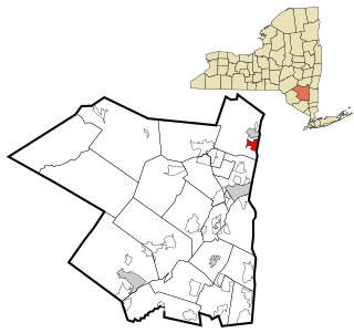
Sullivan County is a county in the U.S. state of New York. As of the 2020 census, the population was 78,624. The county seat is Monticello. The county's name honors Major General John Sullivan, who was labeled at the time as a hero in the American Revolutionary War in part due to his successful campaign against the Iroquois.

<span class="mw-page-title-main">Clermont, New York</span> Town in New York, United States

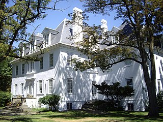
Clermont is a town in Columbia County, New York, United States. The population was 1,965 at the 2010 census. The name of the town is French for "Clear Mountain", in reference to the mountain views in the town.

Jefferson Heights is a hamlet and census-designated place (CDP) in Greene County, New York, United States. The population was 1,122 at the 2020 census.

<span class="mw-page-title-main">Blauvelt, New York</span> Census-designated place in New York, United States

Blauvelt is a hamlet, about 20 miles northwest of New York City. It was a census-designated place, formerly known as Greenbush and then Blauveltville, in the town of Orangetown, Rockland County, New York, United States. It is located north of Tappan, east of Nauraushaun and Pearl River, south of Central Nyack, and west of Orangeburg. As of the 2010 census, the CDP had a population of 5,689.

<span class="mw-page-title-main">Congers, New York</span> Census-designated place in New York, United States

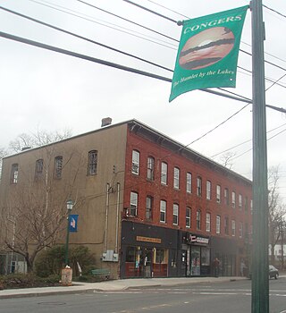
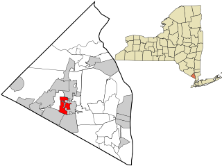
Congers is a suburban hamlet and census-designated place in the town of Clarkstown, Rockland County, New York, United States. It is located north of Valley Cottage, east of New City, across Lake DeForest, south of Haverstraw, and west of the Hudson River. It lies 19 miles (31 km) north of New York City's Bronx boundary. As of the 2020 census, the population was 8,532.

<span class="mw-page-title-main">Monsey, New York</span> CDP in New York, United States

Monsey is a hamlet and census-designated place in the town of Ramapo, Rockland County, New York, United States, located north of Airmont, east of Viola, south of New Hempstead, and west of Spring Valley. The village of Kaser is surrounded by the hamlet of Monsey. The 2020 census listed the population at 26,954; a 46% increase since the 2010 census.

<span class="mw-page-title-main">Thiells, New York</span> Census-designated place in New York, United States

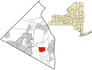
Thiells, known as Thiell's Corner in the 1850s, is a hamlet and census-designated place (CDP) in the town of Haverstraw, Rockland County, New York, United States. It is located north of Mount Ivy, east of Pomona, south of Tomkins Cove, and west of Garnerville. The population was 5,240 as of the 2020 census.

<span class="mw-page-title-main">Viola, New York</span> Census-designated place in New York, United States

Viola is a hamlet and census-designated place in the town of Ramapo, Rockland County, New York, United States. It is located north of Airmont, east of Montebello, south of Wesley Hills, and west of Hillcrest. The population was 6,868 at the 2010 census.

<span class="mw-page-title-main">West Nyack, New York</span> Census-designated place in New York, United States

West Nyack is a hamlet and census-designated place in the town of Clarkstown, Rockland County, New York, United States. It is located north of Blauvelt, east of Nanuet, southwest of Valley Cottage, southeast of Bardonia, and west of Central Nyack. It is approximately 18 miles (29 km) north of New York City. The population was 3,439 at the 2010 census.

<span class="mw-page-title-main">Narrowsburg, New York</span> CDP in New York, United States

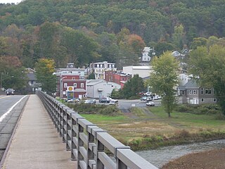
Narrowsburg is a hamlet in Sullivan County, New York, United States. The population was 379 at the 2020 census. Narrowsburg is in the western part of the Town of Tusten at the junction of Routes 52 and 97.

<span class="mw-page-title-main">Neversink, New York</span> Town in New York, United States

Neversink is a town in Sullivan County, New York, United States. The population was 3,366 at the 2020 census.

<span class="mw-page-title-main">Rock Hill, New York</span> CDP in New York, United States

Rock Hill is a hamlet in Sullivan County, New York, United States. At the 2020 census the population was 2,369.

<span class="mw-page-title-main">Rockland, New York</span> Town in Sullivan County, New York, US

Rockland is a town in the northern part of Sullivan County, New York, United States. At the 2020 census, the population was 3,290.

<span class="mw-page-title-main">Roscoe, New York</span> CDP in New York, United States

Roscoe is a hamlet in Sullivan County, New York, United States. The population was 497 at the 2020 census.

<span class="mw-page-title-main">Glasco, New York</span> CDP in New York, United States

Glasco is a hamlet in Ulster County, New York, United States. The population was 2,013 at the 2020 census.

<span class="mw-page-title-main">Shokan, New York</span> CDP in New York, United States

Shokan is a hamlet located in the town of Olive in Ulster County, New York, United States, within the Catskill Park. The population was 1,075 at the 2020 census.

<span class="mw-page-title-main">Sheppton, Pennsylvania</span> CDP in Pennsylvania, United States

Sheppton is a census-designated place (CDP) in Schuylkill County, Pennsylvania, United States. The population was 239 at the 2000 census.

<span class="mw-page-title-main">Callicoon (CDP), New York</span> CDP in New York, United States

Callicoon is a hamlet and census-designated place in the Town of Delaware, Sullivan County, New York, United States. The population was 206 at the 2020 census.

De Bruce is a small hamlet located in Sullivan County, New York, United States.

<span class="mw-page-title-main">Willowemoc Creek</span> River in New York, United States

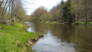
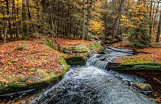
Willowemoc Creek is a tributary of Beaver Kill. It is a popular trout fishing stream near the Catskill Park in Sullivan County, New York.

References

  1. "ArcGIS REST Services Directory". United States Census Bureau. Retrieved September 20, 2022.
  2. "Robert R. Livingston and the American Revolution". Archived from the original on October 13, 2007. Retrieved October 17, 2008.
  3. 1 2 "LM Timeline".
  4. , Livingston Manor website
  5. "National Register Information System". National Register of Historic Places . National Park Service. March 13, 2009.
  6. 1 2 Kilgannon, Corey (June 13, 2004). "Livingston Manor Journal; A Fishing Magnet in the Catskills, Reeling in More Than Just Anglers". The New York Times.
  7. "In DeBruce, they wrangle fish", SC-Democrat, 23 May 2008
  8. "Community honors Livingston Manor state champs". recordonline.com. Retrieved October 18, 2015.
  9. "US Gazetteer files: 2010, 2000, and 1990". United States Census Bureau. February 12, 2011. Retrieved April 23, 2011.
  10. "All About the CAS Arts Center". Catskill Art Society. Retrieved October 9, 2013.
  11. "Census of Population and Housing". Census.gov. Retrieved June 4, 2016.
  12. "U.S. Census website". United States Census Bureau . Retrieved January 31, 2008.
  13. Ewen, David (1987). American Songwriters: an H.W. Wilson biographical dictionary . New York: H.W. Wilson. p.  40. ISBN   978-0-8242-0744-1.