Phoenicia, New York

Last updated

Phoenicia
CDP and hamlet
Downtown Phoenicia, NY.jpg
View along Main Street
Etymology: From Phoenix tannery
Ulster County New York incorporated and unincorporated areas Phoenicia highlighted.svg
Location in Ulster County and the state of New York.
Coordinates: 42°4′53″N74°18′47″W / 42.08139°N 74.31306°W / 42.08139; -74.31306
CountryUnited States
State New York
Region Catskills
County Ulster
Area
[1]
  Total0.46 sq mi (1.18 km2)
  Land0.46 sq mi (1.18 km2)
  Water0.00 sq mi (0.00 km2)
Elevation
827 ft (252 m)
Population
 (2020)
  Total268
  Density589.01/sq mi (227.31/km2)
Time zone UTC-5 (EST)
  Summer (DST) UTC-4 (EDT)
ZIP Code
12464
Area code 845
Exchange 688
FIPS code 36-57650
GNIS feature ID0960320

Phoenicia is a hamlet (and census-designated place) of Shandaken in Ulster County, New York, United States. The population was 268 at the 2020 census, making it the second highest populated community in the town. The village center is located just off Route 28 at its junction with Route 214 and is nestled at the base of three peaks, Mount Tremper, Romer Mountain, and Sheridan Mountain. The community sits at the confluence of the Esopus Creek and Stony Clove Creek. A popular getaway for New Yorkers, the hamlet has frequented many tourism guides as among the best vacation towns in the greater New York City area. [2] [3] [4]

Contents

History

The geographic area that would eventually be named Phoenicia was fertile hunting and fishing land for the Mohawk, Mohican, and Lenape peoples for hundreds of years before European settlers arrived. Of particular note are the Esopus Lenape, who are believed to be the people who spent the most time in the area.

The first European settlement in the area is believed to be in the mid-18th century, as Ulster county as a whole began to see more European immigration and land access in the more fertile lower valleys became restricted. These access restrictions particularly began to push poorer subsistence farmers into the Catskill mountains. Most of these early settlers were of Dutch, English, and Scottish origin, with Dutch being the most commonly spoken European language.

The 19th century saw industry move into the area, with tanning becoming the dominant employer early and eventually ceding to bluestone quarrying towards the latter half of the century. This era saw the decline of Dutch cultural dominance.

The hamlet housed the Phoenix Tannery from 1836 until it closed around 1870, eventually burning down in 1873. [5] The Phoenix, along with most of the new industry in the area, primarily employed recent Irish immigrants and was at different times known as the Newkirk and Simpson Tannery, Simpson Tannery, Simpson's Tannery, and Edinburg Tannery. Many believe the Phoenix Tannery is the source of the hamlet's name.

Tubing on the Esopus Creek in Phoenicia (1978) Tubers in Phoenicia, NY.jpg
Tubing on the Esopus Creek in Phoenicia (1978)

As the extractive industries of tanning and quarrying began to wane in the region towards the latter half of the 1800s, tourism began to take off with Phoenicia a major center. An 1879 article from the New York Times, "In The Ulster Catskills: Attractions of Shandaken Valley", notes "many thousands of people will come [to the Catskills] annually to escape the heat of the pent-up cities, and spend some of their hard-earned money in gaining renewed strength and vigor of body and mind." [6]

The Ulster and Delaware Railroad arrived at this community first, making it the first to develop the tourist industry which is still a major part of the local economy. The New York Central Railroad acquired the railroad on February 1, 1932. It continued passenger service through the development, albeit only once-daily except Sundays in its final years. That service ended on March 31, 1954. [7] [8]

In 1960, the Empire State Railway Museum opened in the historic Ulster & Delaware Phoenicia Railroad Station. [9]

On August 23, 1986, Phoenicia became the home of The Shandaken Eagle, a two-ton cast-iron eagle with a 13 foot wingspan who originally lived atop New York City's Grand Central Depot. [10]

The Phoenicia Railroad Station was listed on the National Register of Historic Places in 1995. [11]

Beginning in 2010, the town hosted the Phoenicia International Festival of the Voice every August. It has moved to New Paltz.

Geography

Phoenicia is located at 42°4′53″N74°18′47″W / 42.08139°N 74.31306°W / 42.08139; -74.31306 (42.081266, -74.313019). [12]

View of Phoenicia, 1910s Phoenicia, NY 1910s.png
View of Phoenicia, 1910s

According to the United States Census Bureau, the CDP has a total area of 0.5 square miles (1.3 km2), all land.

Demographics

Historical population
CensusPop.Note
2000 381
2010 309−18.9%
2020 268−13.3%
U.S. Decennial Census [13]

As of the census [14] of 2000, there were 381 people, 194 households, and 82 families residing in the CDP. The population density was 823.2 inhabitants per square mile (317.8/km2). There were 246 housing units at an average density of 531.5 per square mile (205.2/km2). The racial makeup of the CDP was 96.06% White, 0.26% African American, 0.52% Native American, 0.26% Asian, 0.26% Pacific Islander, and 2.62% from two or more races. Hispanic or Latino of any race were 2.62% of the population.

There were 194 households, out of which 20.1% had children under the age of 18 living with them, 26.8% were married couples living together, 10.3% had a female householder with no husband present, and 57.7% were non-families. 45.4% of all households were made up of individuals, and 23.7% had someone living alone who was 65 years of age or older. The average household size was 1.96 and the average family size was 2.88.

In the CDP, the population was spread out, with 18.1% under the age of 18, 5.8% from 18 to 24, 24.4% from 25 to 44, 28.6% from 45 to 64, and 23.1% who were 65 years of age or older. The median age was 46 years. For every 100 females, there were 87.7 males. For every 100 females age 18 and over, there were 85.7 males.

The median income for a household in the CDP was $22,159, and the median income for a family was $28,000. Males had a median income of $29,250 versus $21,750 for females. The per capita income for the CDP was $15,408. About 5.7% of families and 13.9% of the population were below the poverty line, including none of those under age 18 and 20.5% of those age 65 or over.

The Zip Code for Phoenicia is 12464, and the Area code is 845.

Related Research Articles

<span class="mw-page-title-main">Ulster County, New York</span> County in New York, United States

Ulster County is a county in the U.S. state of New York. It is situated along the Hudson River. As of the 2020 census, the population was 181,851. The county seat is Kingston. The county is named after the Irish province of Ulster.

<span class="mw-page-title-main">Palenville, New York</span> Hamlet and census-designated place in New York, US

Palenville is a hamlet and census-designated place (CDP) in Greene County, New York, United States. The population was 1,002 at the 2020 census.

<span class="mw-page-title-main">Pine Bush, New York</span> CDP in New York, United States

Pine Bush is a hamlet located in the town of Crawford and adjacent to Shawangunk, New York, within Orange and adjacent to Ulster counties in the U.S. It is roughly coterminous with the 12566 ZIP code and 744 telephone exchange in the 845 area code. These both extend into adjacent regions of the town of Shawangunk in Ulster County.. The population was 1,751 at the 2020 census.

<span class="mw-page-title-main">Denning, New York</span> Town in New York, United States

Denning is an isolated town in Ulster County, New York, United States. The population was 493 at the 2020 census. The town is named after an early landowner, William Denning. Denning is located in the western part of the county, deep inside the Catskill Mountains. The location of the town in the Catskill State Park accounts in part for its low population.

<span class="mw-page-title-main">Hardenburgh, New York</span> Town in New York, United States

Hardenburgh is a town located in the western part of Ulster County, New York, United States. The population was 221 at the 2020 census. The town is located inside the Catskill Park.

<span class="mw-page-title-main">Lake Katrine, New York</span> CDP in New York, United States

Lake Katrine is a hamlet in Ulster County, New York, United States. The population was 2,522 at the 2020 census.

<span class="mw-page-title-main">Olive, New York</span> Town in New York, United States

Olive is a town in Ulster County, New York, United States. The town is west of Kingston, New York and is inside the Catskill Park. The population was 4,226 at the 2020 census.

<span class="mw-page-title-main">Pine Hill, New York</span> CDP and hamlet in New York, United States

Pine Hill is a hamlet in the western part of the town of Shandaken in Ulster County, New York, United States. As of the 2020 census, the CDP had a total population of 275.

<span class="mw-page-title-main">Port Ewen, New York</span> CDP in New York, United States

Port Ewen is a hamlet in Ulster County, New York, United States. The population was 3,678 at the 2020 census. Port Ewen is in the Town of Esopus, south of Kingston, along U.S. Route 9W.

<span class="mw-page-title-main">Rifton, New York</span> CDP in New York, United States

Rifton is a hamlet in Ulster County, New York, United States. The population was 481 at the 2020 census.

<span class="mw-page-title-main">Rochester, Ulster County, New York</span> Town in New York, United States

Rochester is a town in Ulster County, New York, United States. The population was 7,272 at the 2020 census. It is an interior town located near the center of Ulster County. The northwestern part of the town is in the Catskill Park.

<span class="mw-page-title-main">Saugerties South, New York</span> CDP in New York, United States

Saugerties South is a hamlet in Ulster County, New York, United States. The population was 2,442 at the 2020 census.

<span class="mw-page-title-main">Shandaken, New York</span> Town in New York, United States

Shandaken is a town on the northern border of Ulster County, New York, United States, northwest of Kingston, New York. As of the 2020 census, the town had a total population of 2,866. The name is believed to be from an Esopus phrase for "land of rapid waters."

<span class="mw-page-title-main">Ulster, New York</span> Town in New York, United States

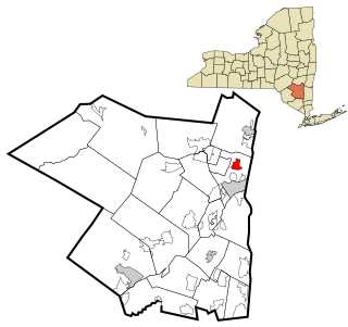
Ulster is a town in Ulster County, New York, United States. The population was 12,660 at the 2020 census.

<span class="mw-page-title-main">Wallkill, Ulster County, New York</span> CDP in New York, United States

Wallkill is a hamlet, generally identified as coterminous with ZIP code 12589, telephone exchange 895 in the 845 area code and most of the Wallkill Central School District located mostly in the eastern half of the town of Shawangunk, Ulster County, New York, United States, but partly spilling over into adjacent regions of the Orange County towns of Newburgh and Montgomery. The population was 2,166 at the 2020 census.

<span class="mw-page-title-main">Catskill (town), New York</span> Town in New York, United States

Catskill is a town in the southeastern section of Greene County, New York, United States. The population was 11,298 at the 2020 census, the largest town in the county. The western part of the town is in the Catskill Park. The town contains a village, also called Catskill. The village of Catskill has a well-defined Main Street. There is a public boat launch on the Hudson River called Dutchman's Landing.

<span class="mw-page-title-main">Esopus Creek</span> Tributary of the Hudson River in the Catskill region of New York state

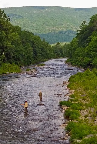
Esopus Creek is a 65.4-mile-long (105.3 km) tributary of the Hudson River that drains the east-central Catskill Mountains in the U.S. state of New York. From its source at Winnisook Lake on the slopes of Slide Mountain, the Catskills' highest peak, it flows across Ulster County to the Hudson at Saugerties. Many tributaries extend its watershed into neighboring Greene County and a small portion of Delaware County. Midway along its length, it is impounded at Olive Bridge to create Ashokan Reservoir, the first of several built in the Catskills as part of New York City's water supply system. Its own flow is supplemented 13 miles (21 km) above the reservoir by the Shandaken Tunnel, which carries water from the city's Schoharie Reservoir into the creek.

<span class="mw-page-title-main">Hurley, New York</span> Town in New York, United States

Hurley is a town in Ulster County, New York, United States. The population was 6,178 at the 2020 census. The town is in the northeastern part of the county, west of the city of Kingston. Much of the town is inside the Catskill Park. Located within the town is a hamlet and census-designated place, also named Hurley. The Town of Hurley comprises the hamlets of Hurley, West Hurley and Glenford.

<span class="mw-page-title-main">Kingston (town), New York</span> Town in Ulster County, New York, US

Kingston is a town in Ulster County, New York, United States. The Town of Kingston is in the northeastern part of Ulster County, north of the City of Kingston. Kingston is inside the Catskill Park. The population was 933 at the 2020 census.

<span class="mw-page-title-main">Woodstock, New York</span> Town in New York, United States

Woodstock is a town in Ulster County, New York, United States, in the northern part of the county, northwest of Kingston. It lies within the borders of the Catskill Park. The population was 6,287 at the 2020 census, up from 5,884 in 2010.

References

  1. "ArcGIS REST Services Directory". United States Census Bureau. Retrieved September 20, 2022.
  2. Travel, Budget (July 27, 2011). "10 Coolest Small Towns in America 2011". Budget Travel. Retrieved February 3, 2020.
  3. Plitt, Amy (June 26, 2018). "A guide to the small towns of Hudson Valley and the Catskills". Curbed NY. Retrieved February 3, 2020.
  4. escapebrooklynpage (July 18, 2014). "A Guide to Phoenicia, New York". ESCAPE BROOKLYN. Retrieved February 3, 2020.
  5. "Phoenix Tannery". www.phoenixtannery.com. Retrieved February 3, 2020.
  6. Ordansky, Jesse. "Phoenicia: The Secret of the Catskills". Chronogram Magazine. Retrieved February 3, 2020.
  7. New York Central Timetable, December 1953, Table 50
  8. New York Central Timetable, April 1954,dropped from timetable.
  9. "Empire State Railway Museum - Home". esrm.com. Retrieved February 4, 2020.
  10. "UPSTATE, NEW PERCH FOR AN OLD EAGLE". timesmachine.nytimes.com. Retrieved February 3, 2020.
  11. "National Register Information System". National Register of Historic Places . National Park Service. July 9, 2010.
  12. "US Gazetteer files: 2010, 2000, and 1990". United States Census Bureau. February 12, 2011. Retrieved April 23, 2011.
  13. "Census of Population and Housing". Census.gov. Retrieved June 4, 2016.
  14. "U.S. Census website". United States Census Bureau . Retrieved January 31, 2008.