
Ulster County is a county in the U.S. state of New York. It is situated along the Hudson River. As of the 2020 census, the population was 181,851. The county seat is Kingston. The county is named after the Irish province of Ulster.

The United States Census Bureau (USCB), officially the Bureau of the Census, is a principal agency of the U.S. Federal Statistical System, responsible for producing data about the American people and economy. The Census Bureau is part of the U.S. Department of Commerce and its director is appointed by the President of the United States.

In the United States, a metropolitan statistical area (MSA) is a geographical region with a relatively high population density at its core and close economic ties throughout the area. Such regions are neither legally incorporated as a city or town would be, nor are they legal administrative divisions like counties or separate entities such as states; because of this, the precise definition of any given metropolitan area can vary with the source. The statistical criteria for a standard metropolitan area were defined in 1949 and redefined as metropolitan statistical area in 1983.

Fort Garland is an unincorporated town, a post office, and a census-designated place (CDP) located in and governed by Costilla County, Colorado, United States. The Fort Garland post office has the ZIP Code 81133. At the United States Census 2010, the population of the Fort Garland CDP was 433, while the population of the 81133 ZIP Code Tabulation Area was 840 including adjacent areas.

Patterson is a town in Putnam County, New York, United States. The town is in the northeastern part of the county. Interstate 84 passes through the southwestern section of the town. The population was 12,023 at the 2010 census. The town is named after early farmer Matthew Paterson. The reason Patterson was spelled with two "t"s was due to the looseness with which Paterson spelled his own last name.

Shawangunk is a town in southwestern Ulster County, New York, United States. The population was 14,332 at the 2010 census. The town takes its name from its largest stream, the Shawangunk Kill. The name Shawangunk is from the language of the Lenape people. Kill is an abbreviation of the Dutch word for creek, Killitje. It is pronounce Shuh-Whan-Gung

Wallkill is a hamlet, generally identified as coterminous with ZIP code 12589, telephone exchange 895 in the 845 area code and most of the Wallkill Central School District located mostly in the eastern half of the Town of Shawangunk, Ulster County, New York, United States, but partly spilling over into adjacent regions of the Orange County towns of Newburgh and Montgomery. The population was 2,288 at the 2010 census.
A census-designated place (CDP) is a concentration of population defined by the United States Census Bureau for statistical purposes only. CDPs have been used in each decennial census since 1980 as the counterparts of incorporated places, such as self-governing cities, towns, and villages, for the purposes of gathering and correlating statistical data. CDPs are populated areas that generally include one officially designated but currently unincorporated community, for which the CDP is named, plus surrounding inhabited countryside of varying dimensions and, occasionally, other, smaller unincorporated communities as well. CDPs include small rural communities, edge cities, colonias located along the Mexico–United States border, and unincorporated resort and retirement communities and their environs.
New York's 9th congressional district is a congressional district for the United States House of Representatives in New York City, represented by Yvette Clarke.
New York's 11th congressional district is a congressional district for the United States House of Representatives in New York City. The 11th district includes all of Staten Island and parts of southern Brooklyn, including the neighborhoods of Bay Ridge, Bath Beach, Dyker Heights, south western Gravesend, western Sheepshead Bay, and parts of southern Bensonhurst. The 11th District is currently represented by Republican Nicole Malliotakis, who is currently the only Republican to represent any part of New York City in Congress. Malliotakis was first elected in 2020, defeating one-term incumbent Democrat Max Rose.
The following is a set–index article, providing a list of lists, for the cities, towns and villages within the jurisdictional United States. It is divided, alphabetically, according to the state, territory, or district name in which they are located.
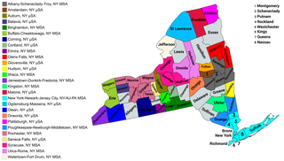
The U.S. State of New York currently has 34 statistical areas that have been delineated by the Office of Management and Budget (OMB). On March 6, 2020, the OMB delineated seven combined statistical areas, 14 metropolitan statistical areas, and 13 micropolitan statistical areas in New York.
Lansing is a town in Tompkins County, New York, United States. The population was 11,033 at the 2010 census. The town is named after John Lansing. People from Lansing were early settlers of Lansing, Michigan, and named it after their hometown; it later became the capital of Michigan.
This article includes information about the 100 most populous incorporated cities, the 100 most populous core-based statistical areas (CBSAs), and the 100 most populous primary statistical areas (PSAs) of the United States and Puerto Rico. This information is displayed in two tables. The first table ranks the cities, CBSAs, and PSAs separately by population. The second table displays the areas in hierarchical order by the most populous PSA, then most populous CBSA, and then most populous city.
Pashtun Americans are Americans who are of ethnic Pashtun origin, hailing from Afghanistan and Pakistan.


