Greene County is a county located in the U.S. state of New York. As of the 2020 census, the population was 47,931. Its county seat is Catskill. The county's name is in honor of the American Revolutionary War general Nathanael Greene.

Ulster County is a county in the U.S. state of New York. It is situated along the Hudson River. As of the 2020 census, the population was 181,851. The county seat is Kingston. The county is named after the Irish province of Ulster.

Denning is an isolated town in Ulster County, New York, United States. The population was 551 at the 2010 census. The town is named after an early landowner, William Denning. Denning is located in the western part of the county, deep inside the Catskill Mountains. The location of the town in the Catskill State Park accounts in part for its low population.

Hardenburgh is a town located in the western part of Ulster County, New York, United States. The population was 215 at the 2010 census. The town is located inside the Catskill Park.
High Falls is a hamlet in Ulster County, New York, United States. The population was 627 at the 2010 census.

Highland is a hamlet in Ulster County, New York, United States. The population was 5,647 at the 2010 census. It is part of the New York City Combined Statistical area.

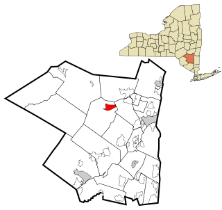
Marbletown is a town in Ulster County, New York, United States. The population was 5,658 at the 2020 census. It is located near the center of Ulster County, southwest of the City of Kingston. US 209 and NY 213 pass through the town. It is at the eastern edge of the Catskill Park.

Olive is a town in Ulster County, New York, United States. The town is west of Kingston, New York and is inside the Catskill Park. The population was 4,419 at the 2010 census.
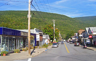
Phoenicia is a hamlet of Shandaken in Ulster County, New York, United States. The population was 309 at the 2010 census, making it the highest populated community in the town. The village center is located just off Route 28 at its junction with Route 214 and is nestled at the base of three peaks, Mount Tremper, Romer Mountain, and Sheridan Mountain. The community sits at the confluence of the Esopus Creek and Stony Clove Creek. A popular getaway for New Yorkers, the hamlet has frequented many tourism guides as among the best vacation towns in the greater New York City area.

Rochester is a town in Ulster County, New York, United States. The population was 7,313 at the 2010 census. It is an interior town located near the center of Ulster County. The northwestern part of the town is in the Catskill Park.

Shandaken is a town on the northern border of Ulster County, New York, United States, northwest of Kingston, New York. As of the 2010 census, the town had a total population of 3,085. The name is believed to be from an Esopus phrase for "land of rapid waters."
Shokan is a hamlet located in the town of Olive in Ulster County, New York, United States, within the Catskill Park. The population was 1,183 at the 2010 census.
Stone Ridge is a hamlet in Ulster County, New York, United States. The population was 1,173 at the 2010 census.

Wawarsing is a town in Ulster County, New York, United States. The population was 13,157 at the 2010 census. The name Wawarsing was once believed to mean "a place where the streams wind" in the Lenape language, referring to the geography in the hamlet of Wawarsing. Specifically, the joining of the Ver Nooy Kill and the Rondout Creek at Port Ben. The name Wawarsing was used by the Lenape to designate the current hamlet and the fields to the north and south of it for at least six miles in both directions. It is the only Lenape name known to refer to an exact location in Ulster County.
Goldens Bridge is a hamlet and census-designated place (CDP) in the town of Lewisboro in Westchester County, New York, United States. The population was 1,630 at the 2010 census.
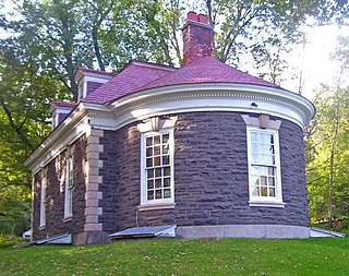
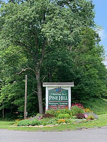
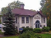
Morton Memorial Library is located on Elm Street in Pine Hill, New York, United States. It is a stone building in the Georgian Revival architectural style built at the beginning of the 20th century.
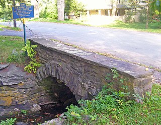
The Elm Street Stone Arch Bridge is located along that street in Pine Hill, New York, United States. It is a short bridge built over Alton Creek in the early 20th century using stonemasonry techniques and an arch bridge design that had been employed in the Catskills since the 18th century, one. As one of the few extant and intact bridges in that style in the region, it was listed on the National Register of Historic Places in 1996 along with the nearby Mill Street Stone Arch Bridge. It is located in the Pine Hill Historic District.

The Mill Street Stone Arch Bridge is located on that street in Pine Hill, New York, United States. It is a small bridge over a local creek built around the turn of the 20th century. It is one of two stone arch bridges in the former village built by local stonemason Matthew G. Thompson. It has remained intact and in use since then, and was listed on the National Register of Historic Places in 1996. It is located in the Pine Hill Historic District.

The former District School No. 14 building is located on Academy Street in Pine Hill, New York, United States. It is a concrete-sided frame building erected in the mid-1920s.

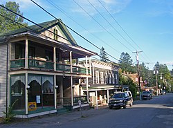
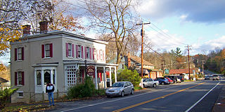
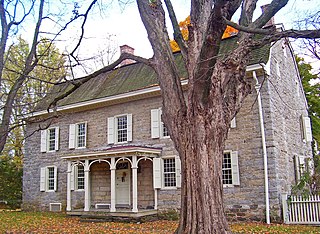
Pine Hill Historic District is a national historic district located at Pine Hill, Ulster County, New York. It encompasses 125 contributing buildings, 3 contributing sites, 2 contributing structures, and 1 contributing object in the hamlet of Pine Hill. It developed between about 1800 and 1962 and includes notable examples of Greek Revival, Carpenter Gothic, Italianate, Stick Style, Second Empire, Queen Anne, Colonial Revival, Classical Revival, and Bungalow / American Craftsman architecture. Located in the district are the separately listed District School No. 14, Elm Street Stone Arch Bridge, Mill Street Stone Arch Bridge, Morton Memorial Library, and Ulster House Hotel. Other notable contributing resources include the John C. Loomis House, Methodist Episcopal Church, Benjamin Franklin Cornish House, Elizabeth Smith House (1876), Orchard Park House (1882), and "The Zepher".
 District School Number 14
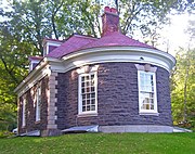 Morton Memorial Library
 Ulster House Hotel (now private residence)
 Elm Street Stone Arch Bridge
 Mill Street Stone Arch Bridge
 Pine Hill Fire Department (now private residence)
 Smith Brothers Druggists
 Orchard Park House