Panabo

Last updated

Panabo
City of Panabo
Panabo City heading to Tagum City.jpg
Downtown area
Flag of Panabo, Davao del Norte.png
Panabo Davao del Norte.png
Nickname: 
Banana Capital of Davao del Norte
Ph locator davao del norte panabo.png
Map of Davao del Norte with Panabo highlighted
OpenStreetMap
Panabo
Philippines location map (square).svg
Red pog.svg
Panabo
Location within the Philippines
Coordinates: 7°18′N125°41′E / 7.3°N 125.68°E / 7.3; 125.68
Country Philippines
Region Davao Region
Province Davao del Norte
District 2nd district
Founded July 19, 1949
CityhoodMarch 31, 2001
Barangays 40 (see Barangays)
Government
[1]
  Type Sangguniang Panlungsod
   Mayor Jose E. Relampagos (Reporma)
   Vice Mayor Janrey G. Gavina (HNP)
   Representative Alan R. Dujali (HNP)
   City Council
Members
   Electorate 127,668 voters (2022)
Area
[2]
  Total251.23 km2 (97.00 sq mi)
Elevation
74 m (243 ft)
Highest elevation
555 m (1,821 ft)
Lowest elevation
0 m (0 ft)
Population
 (2020 census) [3]
  Total209,230
  Density830/km2 (2,200/sq mi)
   Households
51,097
Demonym Panaboan
Economy
   Income class 3rd city income class
   Poverty incidence
8.65
% (2018) [4]
   Revenue 1,307 million (2020)
   Assets 3,770 million (2020)
   Expenditure 1,093 million (2020)
   Liabilities 819.9 million (2020)
Service provider
   Electricity Davao Light and Power Company (DLPC)
Time zone UTC+8 (PST)
ZIP code
8105
PSGC
IDD : area code +63(0)84
Native languages Ata Manobo
Davawenyo
Cebuano
Kalagan
Tagalog
Website www.panabocity.gov.ph

Panabo, officially the City of Panabo (Cebuano : Dakbayan sa Panabo; Filipino : Lungsod ng Panabo), is a 3rd class component city in the province of Davao del Norte, Philippines. According to the 2020 census, it has a population of 209,230 people. [3]

Contents

Panabo is part of Davao Metropolitan Area as it shares borders with Davao City. It has an area of 25,123 hectares (62,080 acres). The Panabo City Hall is located about 2.23 kilometers from its boundary with Davao City.

Etymology

The name Panabo originated from the phrase "pana-sa-boboy" where "pana" means "arrow", the tool which the original inhabitants of the place, the Aetas, use when hunting wild animals for food. [5]

History

Originally the rich lowland of what today is Panabo was inhabited by a group of natives called Aetas. These people led nomadic life and lived by hunting. With the use of their most essential tool, the bow and arrow—"pana-sa-boboy" as they call it—they hunted for food which primarily consisted of rootcrops and meat of wild boars. [5]

Settlers and pioneers from the Visayas and Luzon started to flock the place during the early 1900s in search of a new life in the region. When the first batch of settlers arrived on the place, in what is now the urban core of the city, they found out that it was already a thriving community, and thus called it Taboan, or trading center. Feeling alienated with the massive influx of settlers in the region, the Aeta natives moved further into the hinterlands to the west, thus ensuring that the settler inhabitants become the majority of the population. The new inhabitants started to name the place as Panabo, named after the bow and arrow that the Aeta natives always carry.

Panabo, until then only a mere barangay of Tagum, then known as Magugpo during that time, became a town on July 19, 1949, through Presidential Proclamation No. 236 of the President Manuel A. Roxas.

The Tagum Agricultural Development Company, otherwise known as TADECO, was founded on December 20, 1950, in the town of Panabo. [6] It was the birth of the world's largest Cavendish banana plantation that saw the mass employment of the locals seeking for jobs, and the start of unprecedented growth of the town as even larger throngs of Visayan migrants settled on the town eager to join the plantation's workforce. Large areas of forests were cleared to make way for the banana trees under TADECO. The town of Panabo grew both in economic terms and population as decades passed since the founding of TADECO and numerous businesses were then set up locally, until the conditions finally warranted for its conversion into a city.

Cityhood

The local government unit of Panabo was created into a component city of Davao del Norte by virtue of Republic Act No. 9015 [7] and ratified by the residents in a plebiscite held on March 31, 2001. However, its official existence as a municipal corporation took effect on with the appointment of new set of officials.

Geography

The city of Panabo has a total land area of 251.23 km2. It was bordered by the shores of Davao Gulf to the east, by Davao City to its west and south, and some of the municipalities of Davao del Norte in the north. The western part of the city featured hills while the rest were flatlands.

Climate

Climate data for Panabo City
MonthJanFebMarAprMayJunJulAugSepOctNovDecYear
Mean daily maximum °C (°F)29
(84)
30
(86)
30
(86)
30
(86)
31
(88)
31
(88)
30
(86)
30
(86)
30
(86)
30
(86)
30
(86)
30
(86)
30
(86)
Mean daily minimum °C (°F)22
(72)
22
(72)
22
(72)
22
(72)
23
(73)
24
(75)
24
(75)
24
(75)
24
(75)
24
(75)
23
(73)
22
(72)
23
(73)
Average precipitation mm (inches)98
(3.9)
86
(3.4)
91
(3.6)
83
(3.3)
133
(5.2)
158
(6.2)
111
(4.4)
101
(4.0)
94
(3.7)
117
(4.6)
131
(5.2)
94
(3.7)
1,297
(51.2)
Average rainy days16.414.316.318.525.325.023.821.920.824.424.318.7249.7
Source: Meteoblue (modeled/calculated data, not measured locally) [8]

Barangays

Panabo is politically subdivided into 40 barangays. [9] Each barangay consists of puroks while some have sitios.

Quezon was formerly the sitio of Cabili; it became a barrio in 1957. [10]

  • A. O. Floirendo
  • Datu Abdul Dadia
  • Buenavista
  • Cacao
  • Cagangohan
  • Consolacion
  • Dapco
  • Gredu (Poblacion)
  • J.P. Laurel
  • Kasilak
  • Katipunan
  • Katualan
  • Kauswagan
  • Kiotoy
  • Little Panay
  • Lower Panaga (Roxas)
  • Mabunao
  • Maduao
  • Malativas
  • Manay
  • Nanyo
  • New Malaga (Dalisay)
  • New Malitbog
  • New Pandan (Poblacion)
  • New Visayas
  • Quezon
  • Salvacion
  • San Francisco (Poblacion)
  • San Nicolas
  • San Pedro
  • San Roque
  • San Vicente
  • Santa Cruz
  • Santo Niño (Poblacion)
  • Sindaton
  • Southern Davao
  • Tagpore
  • Tibungol
  • Upper Licanan
  • Waterfall

Demographics

Population census of Panabo
YearPop.±% p.a.
1960 42,509    
1970 42,920+0.10%
1975 53,015+4.33%
1980 71,098+6.04%
1990 110,390+4.50%
1995 130,585+3.20%
YearPop.±% p.a.
2000 133,950+0.55%
2007 154,329+1.97%
2010 174,364+4.54%
2015 184,599+1.09%
2020 209,230+2.49%
Source: Philippine Statistics Authority [11] [12] [13] [14]

Economy

Banana plantations in Panabo Banana Plantation Panabo City.jpg
Banana plantations in Panabo

Being an agro-industrial city, Panabo is known as the "Banana Capital of the Philippines" due to numerous banana plantations scattered throughout the city. In fact, Panabo is the home of the world's biggest banana plantation, which is owned by the Tagum Agricultural Development Company (TADECO), which covers around 6,900 hectares of banana fields and produce millions of boxes of export-quality bananas annually. The city itself cultivated 40% of its land or around 10,000 hectares into planting export-quality Cavendish bananas. Thus, banana cultivation and exportation are the main economic lifeblood of the city.

Infrastructure

Panabo City Hall Pink Beetle at Panabo City Hall.jpg
Panabo City Hall

There are two privately owned port facilities in the city, which enabled them to export various fruits, such as bananas, mangoes, papayas, and pineapples, to countries like Japan, South Korea, China, and countries as far in the Middle East and the European Union.

Public infrastructure includes the Freedom Park which features a unique banana inspired fountain sculpted by the world class artist Kublai Millan. The Panabo Multi-Purpose Cooperative Tourism Gymnasium, located beside the City Hall is also a public infrastructure, the gymnasium accommodates an estimated ten-thousand people and also serves as playing venue of the Philippine Basketball Association as well as serving concerts for the city.

Transportation

Panabo is served by the 6-lane Maharlika Highway and is a highway road junction heading to the TADECO banana plantation as well as to other parts of Davao del Norte and the northernmost areas of Davao City. Tricycles and jeepneys are the main mode of transportation in the city, while passenger buses and public utility vans serve overland routes within and outside the city.

Education

Tertiary education

Universities

Colleges

Secondary education

High-schools

  • Davao del Norte State College Laboratory School (private)
  • North Davao Colleges - High School Department (private)
  • Maryknoll College of Panabo (private)
  • Francisco Adlaon Learning Institute (private)
  • Panabo SDA Learning Center (private)
  • Panabo Christian School (private)
  • Panabo City Senior High School (public)
  • Panabo Achievers Academy (2nd year only) (private)
  • Panabo City National High School (public)
  • Little Panay National High School
  • Colegio de Davao, Panabo City (Private)
  • Good Shepherd Baptist School (Church School)
  • A. O. Floirendo National High School
  • Cagangohan National High School
  • Don Manuel A. Javellana Memorial National High School
  • Kasilak National High School
  • Kauswagan National High School
  • Mabunao National High School
  • Malativas National High School
  • Manay National High School
  • Quezon National High School
  • San Vicente National High School
  • Sindaton National High School
  • Southern Davao National High School [22]

A memorandum of agreement between UP Los Baños College of Agriculture and ANFLOCOR was signed for the establishment of UP Professional School for Agriculture and the Environment (UP PSAE) which will be UPLB's extension campus in Panabo City. [23] [24] [25] In addition, UP Mindanao will also collaborate on some courses and programs to be offered. [26]

Notable personalities

Sister cities

Local

Related Research Articles

<span class="mw-page-title-main">Davao del Norte</span> Province in Davao Region, Philippines

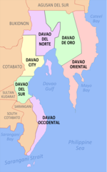
Davao del Norte, officially the Province of Davao del Norte, is a province in the Philippines located in the Davao Region in Mindanao. Its capital and largest city is Tagum. The province also includes Samal Island to the south in Davao Gulf.

<span class="mw-page-title-main">Davao Region</span> Administrative region of the Philippines

Davao Region, formerly called Southern Mindanao, is an administrative region in the Philippines, designated as Region XI. It is situated at the southeastern portion of Mindanao and comprises five provinces: Davao de Oro, Davao del Norte, Davao del Sur, Davao Oriental and Davao Occidental.

<span class="mw-page-title-main">Digos</span> Capital of Davao del Sur, Philippines

Digos, officially the City of Digos, is a 2nd class component city and capital of the province of Davao del Sur, Philippines. According to the 2020 census, it has a population of 188,376 people.

<span class="mw-page-title-main">San Francisco, Agusan del Sur</span> Municipality in Agusan del Sur, Philippines

San Francisco, officially the Municipality of San Francisco, is a 1st class municipality in the province of Agusan del Sur, Philippines. According to the 2020 census, it has a population of 80,760 people.

<span class="mw-page-title-main">Tagum</span> Capital of Davao del Norte, Philippines

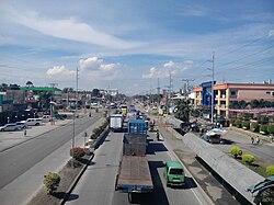
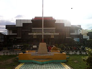
Tagum, officially the City of Tagum, is a 1st class component city and capital of the Davao del Norte, Philippines. According to the 2020 census, it has a population of 296,202 people making it the most populous component city in Mindanao.

<span class="mw-page-title-main">Braulio E. Dujali</span> Municipality in Davao del Norte, Philippines

Braulio E. Dujali, officially the Municipality of Braulio E. Dujali, or simply referred to as Dujali, is a 4th class municipality in the province of Davao del Norte, Philippines. According to the 2020 census, it has a population of 35,729 people.

<span class="mw-page-title-main">Carmen, Davao del Norte</span> Municipality in Davao del Norte, Philippines

Carmen, officially the Municipality of Carmen, is a 1st class municipality in the province of Davao del Norte, Philippines. According to the 2020 census, it has a population of 82,018 people.

<span class="mw-page-title-main">Kapalong</span> Municipality in Davao del Norte, Philippines

Kapalong, officially the Municipality of Kapalong, is a 1st class municipality in the province of Davao del Norte, Philippines. According to the 2020 census, it has a population of 81,068 people.

<span class="mw-page-title-main">Talaingod</span> Municipality in Davao del Norte, Philippines

Talaingod, officially the Municipality of Talaingod, is a 2nd class municipality in the province of Davao del Norte, Philippines. According to the 2020 census, it has a population of 28,333 people.

<span class="mw-page-title-main">Santo Tomas, Davao del Norte</span> Municipality in Davao del Norte, Philippines

Santo Tomas, officially the Municipality of Santo Tomas, is a 1st class municipality in the province of Davao del Norte, Philippines. According to the 2020 census, it has a population of 128,667 people.

<span class="mw-page-title-main">New Corella</span> Municipality in Davao del Norte, Philippines

New Corella, officially the Municipality of New Corella, is a 2nd class municipality in the province of Davao del Norte, Philippines. According to the 2020 census, it has a population of 57,913 people.

<span class="mw-page-title-main">San Isidro, Davao del Norte</span> Municipality in Davao del Norte, Philippines

San Isidro, officially the Municipality of San Isidro, is a 5th class municipality in the province of Davao del Norte, Philippines. According to the 2020 census, it has a population of 27,233 people.

<span class="mw-page-title-main">San Agustin, Isabela</span> Municipality in Isabela, Philippines

San Agustin, officially the Municipality of San Agustin, is a 3rd class municipality in the province of Isabela, Philippines. According to the 2020 census, it has a population of 22,096 people.

<span class="mw-page-title-main">Laak, Davao de Oro</span> Municipality in Davao de Oro, Philippines

Laak, officially the Municipality of Laak, is a 1st class municipality in the province of Davao de Oro, Philippines. According to the 2020 census, it has a population of 79,744 people.

<span class="mw-page-title-main">Mabini, Davao de Oro</span> Municipality in Davao de Oro, Philippines

Mabini, officially the Municipality of Mabini, is a 2nd class municipality in the province of Davao de Oro, Philippines. According to the 2020 census, it had a population of 43,552.

<span class="mw-page-title-main">Mawab</span> Municipality in Davao de Oro, Philippines

Mawab, officially the Municipality of Mawab, is a 3rd class municipality in the province of Davao de Oro, Philippines. According to the 2020 census, it has a population of 39,631 people.

<span class="mw-page-title-main">New Bataan</span> Municipality in Davao de Oro, Philippines

New Bataan, officially the Municipality of New Bataan, is a 1st class municipality in the province of Davao de Oro, Philippines. According to the 2020 census, it has a population of 51,466 people. Geraldford N. Balbin has been its mayor since July 2016.

<span class="mw-page-title-main">San Fernando, Bukidnon</span> Municipality in Bukidnon, Philippines

San Fernando, officially the Municipality of San Fernando, is a 1st class municipality in the province of Bukidnon, Philippines. According to the 2020 census, it has a population of 63,045 people.

<span class="mw-page-title-main">Mati, Davao Oriental</span> Capital of Davao Oriental, Philippines

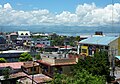
Mati, officially the City of Mati, is a 5th class component city and capital of the province of Davao Oriental, Philippines located on the southeasternmost side of Mindanao and is part of Metropolitan Davao, the second-most populous metropolitan area in the Philippines, and its managing entity, the MDDA. According to the 2020 census, it has a population of 147,547 people.

<span class="mw-page-title-main">Metro Davao</span> Metropolitan area in the Philippines

Metro Davao, officially Metropolitan Davao, is a metropolitan area in Mindanao, Philippines. It includes the cities of Davao, Digos, Mati, Panabo, Samal and Tagum and spanned parts of all five provinces of the Davao Region. Metro Davao is one of three metropolitan areas in the Philippines. It is administered by the Metropolitan Davao Development Authority. It is the largest metropolitan region by land area and the second most populous in the Philippines.

References

  1. City of Panabo | (DILG)
  2. "2015 Census of Population, Report No. 3 – Population, Land Area, and Population Density" (PDF). Philippine Statistics Authority. Quezon City, Philippines. August 2016. ISSN   0117-1453. Archived (PDF) from the original on May 25, 2021. Retrieved July 16, 2021.
  3. 1 2 Census of Population (2020). "Region XI (Davao Region)". Total Population by Province, City, Municipality and Barangay. Philippine Statistics Authority . Retrieved July 8, 2021.
  4. "PSA Releases the 2018 Municipal and City Level Poverty Estimates". Philippine Statistics Authority. December 15, 2021. Retrieved January 22, 2022.
  5. 1 2 "City Profile". Local Government of Panabo City. Archived from the original on December 31, 2012. Retrieved April 30, 2014.
  6. "Incorporated (TADECO, Inc.), Tagum Agricultural Development Company". www.globalgap.org.
  7. "Republic Act No. 9015 | GOVPH".
  8. "Panabo: Average Temperatures and Rainfall". Meteoblue. Retrieved February 29, 2020.
  9. "City of Panabo - Code:112315000 - Philippine Standard Geographic Code (PSGC)". psa.gov.ph. Philippine Statistics Authority. Retrieved February 22, 2022.
  10. "An Act Converting the Sitio of Cabili, Municipality of Panabo, Province of Davao, into a Barrio of Said Municipality to Be Known As the Barrio of Quezon". LawPH.com. Retrieved April 12, 2011.
  11. Census of Population (2015). "Region XI (Davao Region)". Total Population by Province, City, Municipality and Barangay. Philippine Statistics Authority . Retrieved June 20, 2016.
  12. Census of Population and Housing (2010). "Region XI (Davao Region)" (PDF). Total Population by Province, City, Municipality and Barangay. National Statistics Office . Retrieved June 29, 2016.
  13. Censuses of Population (1903–2007). "Region XI (Davao Region)". Table 1. Population Enumerated in Various Censuses by Province/Highly Urbanized City: 1903 to 2007. National Statistics Office.{{cite encyclopedia}}: CS1 maint: numeric names: authors list (link)
  14. "Province of Davao del Norte". Municipality Population Data. Local Water Utilities Administration Research Division. Retrieved December 17, 2016.
  15. "Poverty incidence (PI):". Philippine Statistics Authority. Retrieved December 28, 2020.
  16. "Estimation of Local Poverty in the Philippines" (PDF). Philippine Statistics Authority. November 29, 2005.
  17. "2003 City and Municipal Level Poverty Estimates" (PDF). Philippine Statistics Authority. March 23, 2009.
  18. "City and Municipal Level Poverty Estimates; 2006 and 2009" (PDF). Philippine Statistics Authority. August 3, 2012.
  19. "2012 Municipal and City Level Poverty Estimates" (PDF). Philippine Statistics Authority. May 31, 2016.
  20. "Municipal and City Level Small Area Poverty Estimates; 2009, 2012 and 2015". Philippine Statistics Authority. July 10, 2019.
  21. "PSA Releases the 2018 Municipal and City Level Poverty Estimates". Philippine Statistics Authority. December 15, 2021. Retrieved January 22, 2022.
  22. "Philippines Schools: Panabo City Public High School". July 17, 2012.
  23. "University of the Philippines los Baños - UP-ANFLOCOR sign MOA to develop the UP Prof'l School in Davao". Archived from the original on March 21, 2017. Retrieved March 21, 2017.
  24. "University of the Philippines los Baños - UPLB's harvest on its 108th foundation day: A "refocused"CAFS, a Davao campus, best personnel". Archived from the original on March 21, 2017. Retrieved March 21, 2017.
  25. "UPLB to put up satellite campus in Panabo City". June 29, 2016.
  26. "University of the Philippines Alumni". Archived from the original on March 21, 2017. Retrieved March 21, 2017.