
The Visayas, or the Visayan Islands, are one of the three principal geographical divisions of the Philippines, along with Luzon and Mindanao. Located in the central part of the archipelago, it consists of several islands, primarily surrounding the Visayan Sea, although the Visayas are also considered the northeast extremity of the entire Sulu Sea. Its inhabitants are predominantly the Visayan peoples.

Panay is the sixth-largest and fourth-most populous island in the Philippines, with a total land area of 12,011 km2 (4,637 sq mi) and has a total population of 4,542,926 as of 2020 census. Panay comprises 4.4 percent of the entire population of the country. The City of Iloilo is its largest settlement with a total population of 457,626 inhabitants as of 2020 census.
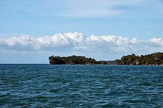
Panay Gulf is an extension of the Sulu Sea, reaching between the islands of Panay and Negros in the Philippines. The gulf contains the island-province of Guimaras and extends into the Iloilo Strait, between Panay and Guimaras, and into Guimaras Strait, between Guimaras and Negros. Guimaras Strait connects Panay Gulf with the Visayan Sea.

Iloilo, officially the Province of Iloilo, is a province in the Philippines located in the Western Visayas region. Its capital is the City of Iloilo, the regional center of Western Visayas. Iloilo occupies a major southeast portion of the Visayan island of Panay and is bordered by the province of Antique to the west, Capiz to the north, the Jintotolo Channel to the northeast, the Guimaras Strait to the east, and the Iloilo Strait and Panay Gulf to the southwest.

Guimaras[ɡimaˈɾas], officially the Province of Guimaras is an island province in the Philippines located in the Western Visayas region. Its capital is Jordan while its largest local government unit is the municipality of Buenavista. The province is situated in the Panay Gulf, between the islands of Panay and Negros. To the northwest is the province of Iloilo and to the southeast is Negros Occidental. The whole island is part of the Metro Iloilo–Guimaras, one of the twelve metropolitan areas of the Philippines.

Iloilo City, officially known as the City of Iloilo, is a 1st class highly urbanized city in the Western Visayas region of the Philippines on the island of Panay. It is the capital city of the province of Iloilo, where it is geographically situated and grouped under the Philippine Statistics Authority, but remains politically independent in terms of government and administration. In addition, it is the center of the Iloilo–Guimaras Metropolitan Area, as well as the regional center and primate city of the Western Visayas region. According to the 2020 census, Iloilo City has a population of 457,626 people. For the metropolitan area, the total population is 1,007,945 people.
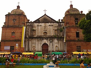
Cabatuan, officially the Municipality of Cabatuan, is a 2nd class municipality in the province of Iloilo, Philippines. According to the 2020 census, it has a population of 61,110 people.
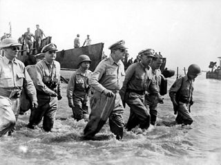
The Philippines campaign, Battle of the Philippines, Second Philippines campaign, or the Liberation of the Philippines, codenamed Operation Musketeer I, II, and III, was the American, Mexican, Australian and Filipino campaign to defeat and expel the Imperial Japanese forces occupying the Philippines during World War II.

The Battle of Visayas was fought by U.S. forces and Filipino guerrillas against the Japanese from 18 March – 15 August 1945, in a series of actions officially designated as Operations Victor I and II, and part of the campaign for the liberation of the Philippines during World War II. The battle was waged to complete the recapture of the central portions south of the archipelago and secure them from remaining Japanese forces.

The Philippine Nautical Highway System, also the Road Roll-on/Roll-off Terminal System (RRTS) or simply the RoRo System, is an integrated network of highway and vehicular ferry routes which forms the backbone of a nationwide vehicle transport system in the Philippines. It is a system of roads and ports developed by the Philippine government to connect the major islands of Luzon, the Visayas and Mindanao. The 919-kilometer (571 mi) nautical highway was opened to the public on April 12, 2003 as the Strong Republic Nautical Highway (SRNH).

Iloilo International Airport, also known as Iloilo Airport, and as Cabatuan Airport, after the municipality of Cabatuan, Iloilo where it is located, is the airport serving the province of Iloilo in the Philippines, including its capital city, Iloilo City, the regional center of the Western Visayas region. It opened its doors to commercial traffic on June 14, 2007, after a decade of planning and construction, replacing Mandurriao Airport in Mandurriao, Iloilo City which had been in service for over seventy years. As a result, the new airport inherited its IATA and ICAO airport codes, as well as its position as the fourth-busiest airport in the Philippines, from its predecessor. It is currently the seventh-busiest airport in the Philippines as of 2021. It is the first airport in both Western Visayas and the island of Panay to be built to international standards, and it is also considered to be the primary gateway into the region. It is classified as an international airport by the Civil Aviation Authority of the Philippines.

Metropolitan Iloilo–Guimaras, also shortened as Metro Iloilo–Guimaras or simply MIG, is a metropolitan area in the Visayas in the Philippines. It consists of the highly urbanized city of Iloilo City; the regional agro-industrial center of Pavia; the municipalities of Cabatuan, Leganes, Oton, San Miguel, and Santa Barbara; and the neighboring island province of Guimaras, with its five municipalities of Jordan, Buenavista, Nueva Valencia, San Lorenzo, and Sibunag.

The Port of Iloilo in Iloilo City, Philippines, serves the province and city of Iloilo and the entire Panay Island, in Western Visayas of the Philippines. It is located away from the older port facilities on the Southern coast of Panay Island, in the Panay Gulf, and one of the country’s safest and most natural harbors. Guimaras Island shields the port from violent storms and makes it ideal for harboring ships and vessels.
Macario Peralta Jr. was a Filipino soldier, lawyer, senator and Secretary of National Defense.

During the Japanese occupation of the islands in World War II, there was an extensive Philippine resistance movement, which opposed the Japanese and their collaborators with active underground and guerrilla activity that increased over the years. Fighting the guerrillas – apart from the Japanese regular forces – were a Japanese-formed Bureau of Constabulary, the Kenpeitai, and the Makapili. Postwar studies estimate that around 260,000 people were organized under guerrilla groups and that members of anti-Japanese underground organizations were more numerous. Such was their effectiveness that by the end of World War II, Japan controlled only twelve of the forty-eight provinces.
Ati (Inati), or Binisaya nga Inati, is an Austronesian language of the island of Panay in the Philippines. The variety spoken in northern Panay is also called Sogodnin. The Ati people also speak Kinaray-a and Hiligaynon.

Tomás Valenzuela Confesor was a Filipino politician and former Senator of the Philippines from 1946 to 1951. He was served as a governor of Iloilo and later, all of Panay Island during the Japanese occupation of the Philippines during World War II. Right after the war, he served as Mayor of Manila and secretary of the Philippine Department of the Interior under President Sergio Osmeña.
The Iloilo–Guimaras–Negros–Cebu Link Bridge is a planned network of bridges in the Visayas in the Philippines connecting the islands of Panay, Guimaras, Negros, and Cebu.

The Federal State of the Visayas was a revolutionary state in the Philippine archipelago during the revolutionary period. It was a proposed administrative unit of a Philippines under a federal form of government.

The Governor of Iloilo is the local chief executive of the Philippine province of Iloilo. The governor holds office at the Iloilo Provincial Capitol located at Bonifacio Drive, Iloilo City. Like all local government heads in the Philippines, the governor is elected via popular vote, and may not be elected for a fourth consecutive term. In case of death, resignation or incapacity, the vice governor becomes the governor. Along with the governors of Aklan, Antique, Capiz, Guimaras and Negros Occidental, he sits in the Regional Development Council of the Western Visayas Region.


