Pilgrim's Rest, South Africa

Last updated
Pilgrims Rest
Pelgrimsrus
Pilgrim Rest.jpg
(1998)
South Africa Mpumalanga location map.svg
Red pog.svg
Pilgrims Rest
South Africa adm location map.svg
Red pog.svg
Pilgrims Rest
Coordinates: 24°54′28″S30°45′24″E / 24.90778°S 30.75667°E / -24.90778; 30.75667
Country South Africa
Province Mpumalanga
District Ehlanzeni
Municipality Thaba Chweu
Area
[1]
  Total25.40 km2 (9.81 sq mi)
Population
 (2011) [1]
  Total1,721
  Density68/km2 (180/sq mi)
Racial makeup (2011)
[1]
   Black African 93.4%
   Coloured 1.5%
   White 4.8%
  Other0.3%
First languages (2011)
[1]
   Northern Sotho 50.4%
   Sotho 15.3%
   Swazi 13.5%
   Tsonga 5.9%
  Other14.8%
Time zone UTC+2 (SAST)
PO box
1290
Area code 013

Pilgrim's Rest (Afrikaans : Pelgrimsrus) is a small museum town in the Mpumalanga province of South Africa which is protected as a provincial heritage site. It was the second of the Transvaal gold fields, attracting a rush of prospectors in 1873, soon after the MacMac diggings started some 5 kilometres (3.1 mi) away. Alluvial panning eventually gave way to deeper ore mining. In the 1970s the town, not greatly changed, became a tourist destination.

Contents

History

The alluvial gold was discovered by prospector Alec Patterson. He panned Pilgrim's Creek, as it became known, when the nearby MacMac diggings became too crowded. [2] He kept his find a secret, but a gold rush resulted when fellow prospector William Trafford registered his claim with the Gold Commissioner at MacMac. [2] After it was officially declared a gold field in September 1873, the town suddenly grew to 1,500 inhabitants searching for alluvial gold.

Mining companies

In the 1880s the alluvial gold dwindled and prospectors were attracted to Barberton's newly discovered gold deposits. Towards the end of the 19th century claims were bought up and underground mining started by the company known as TGME. The better-funded mining companies started mining the deeper gold-bearing ore. By 1895 several small mining companies amalgamated to form the Transvaal Gold Mining Estates (T.G.M.E.). [2] This company was listed on the London Stock Exchange and became the first listed gold mining company in South Africa.

As the volumes of gold ore increased, the engineers constructed small, local hydro-electric plants to generate electricity for the electric tramway and the ore crushers at the reduction works, built in 1897. [2] In 1911 the 2,000 kW Belvedere power station (at 24°39′18″S30°50′12″E / 24.65500°S 30.83667°E / -24.65500; 30.83667 (Belvedere power station) ) was completed on the Blyde River, some 30 km to the east. It supplied hydro-electric power to Pilgrim's Rest and adjacent communities up to 1992. [3] Pilgrim's Rest was southern Africa's second town with street electricity, the first being Kimberley, also a mining town. [2]

Boer war

Pilgrim's Rest was the location of an emergency mint during the Second Boer War. This mint struck the famous and extremely rare Veld Pond.

Graveyard

At the graveyard, every grave was laid facing in the same direction, except for the traditional Robber’s Grave which is laid at right angles to the rest, not facing the rising sun, and emblazoned simply with a cross and the large type words of "Robbers Grave". One legend attributes it to a robber who was shot when he was caught stealing a tent from another miner, while other legends would have it that he instead stole a wheelbarrow, or that the thief died after being lynched.

The most detailed account attributes the grave to a fortune hunter, one Walter Scott, who committed suicide. [4] Scott would have shot his friend Roy Spencer, son of a well-to-do English banker, after they returned drunk from a party. Scott suspected Spencer of stealing his purse of gold. Scott pursued Spencer and shot him near the church, the site of the present graveyard, whereafter Spencer was secretly buried. The sobered-up Scott found his purse in his tent, and committed suicide when he realised what he had done. Scott was then buried in an unmarked grave next to that of his friend, Spencer.

Recent times and tourism

Mining was closed down in 1971 and the village was sold to the government as a national museum. Transvaal Gold Mining Estates Limited started mining again in 1998. It is currently owned by Theta Gold Mines Limited, an Australian listed company. On May 15, 2004, the old TGME reduction works was added to the UNESCO World Heritage tentative List in the Cultural category but was removed in 2016.

The town's original architecture remains largely unchanged since the heyday of the mining era, because the town was declared a National Monument. It became a provincial heritage site in 1986. The village is a cultural heritage site and living museum with a variety of village museums, tours, accommodation, restaurants and shops.

See also

Related Research Articles

<span class="mw-page-title-main">Placer mining</span> Technique of mining stream bed deposits for minerals

Placer mining is the mining of stream bed (alluvial) deposits for minerals. This may be done by open-pit or by various surface excavating equipment or tunneling equipment.

<span class="mw-page-title-main">Mpumalanga</span> Province in South Africa

Mpumalanga is a province of South Africa. The name means "East", or literally "The Place Where the Sun Rises" in the Nguni languages. Mpumalanga lies in eastern South Africa, bordering Eswatini and Mozambique. It shares borders with the South African provinces of Limpopo to the north, Gauteng to the west, the Free State to the southwest, and KwaZulu-Natal to the south. The capital is Mbombela.

<span class="mw-page-title-main">Hhohho Region</span> Place in Eswatini

Hhohho is a region of Eswatini, located in the north western part of the country. Hhohho was named after the capital of King Mswati II, who expanded the Swazi territory to the north and west, taking in the districts of Barberton, Nelspruit, Carolina and Piet Retief. These areas were later acquired by what was the Province of Transvaal and today they form part of the Mpumalanga Province of South Africa. It has an area of 3,625.17 km², a population of 320,651 (2017), and is divided into 14 tinkhundla. The administrative center is the national capital of Mbabane. It borders Lubombo Region on the southeast and Manzini Region in the southwest.

<span class="mw-page-title-main">Witwatersrand Gold Rush</span> Gold rush in Johannesburg, South Africa

The Witwatersrand Gold Rush was a gold rush that began in 1886 and led to the establishment of Johannesburg, South Africa. It was a part of the Mineral Revolution.

Barberton is a town in the Mpumalanga province of South Africa, which has its origin in the 1880s gold rush in the region. It is situated in the De Kaap Valley and is fringed by the Makhonjwa Mountains. It is 43 kilometres (27 mi) south of Mbombela and 360 kilometres (220 mi) east of Johannesburg.

<span class="mw-page-title-main">Graskop</span> Place in Mpumalanga, South Africa

Graskop is a small town in Mpumalanga province, South Africa. It was set up in the 1880s as a gold mining camp but it now serves as a tourist destination and the timber industry. “God’s Window”, a scenic view from the escarpment of the Lowveld below, is located outside the town. Graskop is 14 km south-east of Pilgrim's Rest and 28 km north of Sabie. It was laid out between 1880 and 1890 on a farm belonging to Abel Erasmus, Native Commissioner of the Transvaal Republic. The name is Afrikaans for grassy hillock. Originally it was a mining camp. It is the best place to view the "Edge of the Lowveld", with a sudden drop of 700 metres.

<span class="mw-page-title-main">Mineral Revolution</span> Phase of South African history

The Mineral Revolution is a term used by historians to refer to the rapid industrialisation and economic changes which occurred in South Africa from the 1860s onwards. The Mineral Revolution was largely driven by the need to create a permanent workforce to work in the mining industry, and saw South Africa transformed from a patchwork of agrarian states to a unified, industrial nation. In political terms, the Mineral Revolution had a significant impact on diplomacy and military affairs. Finally, the policies and events of the Mineral Revolution had an increasingly negative impact on race relations in South Africa, and formed the basis of the apartheid system, which dominated South African society for a century. The Mineral Revolution was caused by the discovery of diamonds in Kimberly in 1867 and also by the discovery of gold in Witwatersrand in 1886. The mineral mining revolution laid the foundations of racial segregation and the control of white South Africans over black South Africans. The Mineral Revolution changed South Africa from being an agricultural society to becoming the largest gold producing country in the world.

<span class="mw-page-title-main">Hans Merensky</span> South African geologist, conservationist & philanthropist

Hans Merensky was a South African geologist, prospector, scientist, conservationist and philanthropist.

<span class="mw-page-title-main">Kaapsehoop</span> Place in Mpumalanga, South Africa

Kaapschehoop or Kaapsehoop is a village situated in Mpumalanga province of South Africa.

Leechtown is at the confluence of the Leech River into the Sooke River in southern Vancouver Island, British Columbia. The ghost town, off BC Highway 1 is about 59 kilometres (37 mi) by road northwest of Victoria.

<span class="mw-page-title-main">Robbers Pass</span>

Robbers Pass is situated in the Mpumalanga province, on the R533 between Ohrigstad and Pilgrims Rest.

<span class="mw-page-title-main">Blyde River</span> River in Mpumalanga & Limpopo, South Africa

The Motlatse River, Blyde River, or Umdhlazi River is a river in the Mpumalanga and Limpopo provinces of South Africa. It has a northwards course in steep-sided valleys and ravines of the Mpumalanga Drakensberg, before it enters the lowveld region of the Limpopo province. It has its ultimate origins at around 2,000 m altitude in the Hartebeesvlakte conservation area, to the north of Long Tom Pass. It runs through the Blyde River Canyon.

<span class="mw-page-title-main">Gardner F. Williams</span>

Gardner Frederick Williams was an American mining engineer and author, and the first properly trained mining engineer to be appointed in South Africa.

<span class="mw-page-title-main">Transvaal gold fields</span>

The Transvaal gold fields resulted from gold discoveries during the 19th century in the South African Republic. After insignificant discoveries from 1840 up to 1870, payable or substantial gold deposits were found at:

Bakerville is a town in Ditsobotla Local Municipality in the North West province of South Africa.

<span class="mw-page-title-main">Nuggety Gully Water Race and Chinese Camp</span> Historic site in Queensland, Australia

Nuggety Gully Water Race and Chinese Camp is a heritage-listed mining camp at Mareeba Mining District, Lakeland, Shire of Cook, Queensland, Australia. It was built from c. 1878 to c. 1886. It is also known as Greasy Bill Creek water race, Prospect Creek Stone Walls, and Star of Normanby Mine. It was added to the Queensland Heritage Register on 21 October 1992.

<span class="mw-page-title-main">Kidston State Battery & Township</span> Historic site in Queensland, Australia

Kidston State Battery is a heritage-listed stamper battery at Kidston in Einasleigh, Shire of Etheridge, Queensland, Australia. It was built from 1907 to 1950. It is also known as Kidston Township. It was added to the Queensland Heritage Register on 21 October 1992.

<span class="mw-page-title-main">Panorama Route</span> Road in South Africa

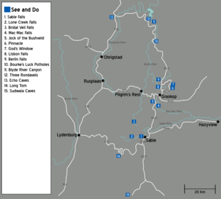
The Panorama Route is a scenic road in South Africa connecting several cultural and natural points of interest. The route, steeped in the history of South Africa, is in Mpumalanga province, centred around the Blyde River Canyon, the world's third largest canyon. It features numerous waterfalls, one of the largest afforested areas in South Africa, and several natural landmarks. The route starts at the foot of the Long Tom Pass just outside Lydenburg, following the natural descent from the Great Escarpment to the Lowveld, and ending at the border of the Mpumalanga and Limpopo provinces near the Echo Caves.

Stonewall Resources is an Australian gold mining company with exploration and development operations in New South Wales, Australia and Mpumalanga Province, South Africa.

<span class="mw-page-title-main">Chris Muller</span> Boer general (1865–1945)

Christiaan Hendrik Muller was a Boer general during the Anglo-Boer War (1899-1902). He succeeded General Ben Viljoen as the sole leader of the Boer forces in the Eastern Transvaal after Viljoen was captured by British troops on 25 January 1902 and sent to St. Helena as a prisoner of war.

References

Notes

  1. 1 2 3 4 "Main Place Pilgrim's Rest". Census 2011.
  2. 1 2 3 4 5 "History". Pilgrim's Rest website. Retrieved 24 December 2013.
  3. Viljoen, Buks (17 March 2011). "Sakesektor moet help met krag". Beeld. Archived from the original on 24 December 2013. Retrieved 24 December 2013.
  4. tourism marketer (3 September 2013). "The Robber's Grave in Pilgrim's Rest". Pilgrim's Rest, Mpumalanga, South Africa. Retrieved 18 August 2016.

Further reading