Pontarddulais (electoral ward)

Last updated

Pontarddulais Ward
Wm swansea pontardulais.jpg
Area15.61 km2 (6.03 sq mi)
Population6,281 (2011 census)
  Density 402/km2 (1,040/sq mi)
Principal area
Ceremonial county
Country Wales
Sovereign state United Kingdom
EU Parliament Wales
UK Parliament
Welsh Assembly
Councillors
  • Phillip Downing(Labour)
  • Jane Harris(Labour)
List of places
UK
Wales
Swansea

Pontarddulais is a name of an electoral ward and parish of the City and County of Swansea, south Wales. The parish of Pontarddulais has its own elected town council.

A community is a division of land in Wales that forms the lowest tier of local government in Wales. Welsh communities are analogous to civil parishes in England. In 2016 there were 870 communities in Wales.

Swansea City & County in Wales

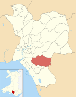
Swansea is a coastal city and county, officially known as the City and County of Swansea in Wales. Swansea lies within the historic county boundaries of Glamorgan and the ancient Welsh commote of Gŵyr on the southwest coast. The county area includes Swansea Bay and the Gower Peninsula. Swansea is the second largest city in Wales and the twenty-fifth largest city in the United Kingdom. According to its local council, the City and County of Swansea had a population of 241,300 in 2014, the second most populous local authority area in Wales after Cardiff. Together with Neath and Port Talbot, Swansea formed a wider Urban Area of 300,352 in 2011.

Wales Country in northwest Europe, part of the United Kingdom

Wales is a country that is part of the United Kingdom. It is bordered by England to the east, the Irish Sea to the north and west, and the Bristol Channel to the south. It had a population in 2011 of 3,063,456 and has a total area of 20,779 km2 (8,023 sq mi). Wales has over 1,680 miles (2,700 km) of coastline and is largely mountainous with its higher peaks in the north and central areas, including Snowdon, its highest summit. The country lies within the north temperate zone and has a changeable, maritime climate.

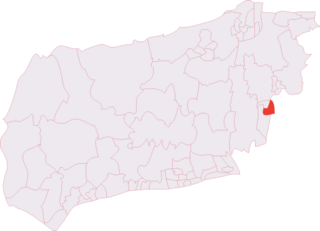
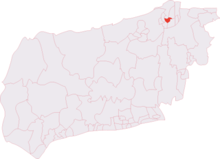
The electoral ward covers the town of Pontarddulais and its surrounding rural areas, in the parliamentary constituency of Gower. The electoral ward is bounded by Mawr to the east; Llangyfelach to the south east; and Penyrheol to the south west.

Pontarddulais town in the City and County of Swansea

Pontarddulais is a community and town in the City and County of Swansea, Wales, situated 10 miles (16 km) northwest of Swansea city centre and falls within the Pontarddulais ward.

Gower (UK Parliament constituency) Parliamentary constituency in the United Kingdom, 1885 onwards

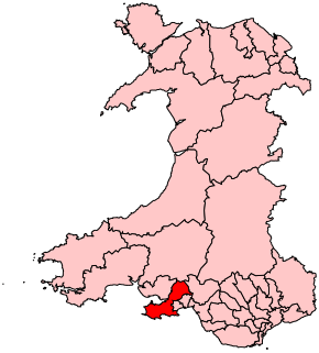
Gower is a constituency created in 1885 represented in the House of Commons of the UK Parliament by one member of parliament (MP). Tonia Antoniazzi, Labour Party became its MP after winning it from a Conservative in the 2017 UK general election. Her party had represented the seat from 1908 until 2015.

Mawr

Mawr is both an electoral ward and a community of the City and County of Swansea, in south Wales, U.K. Mawr has its own elected community council. Its name simply means "large", and it was given the name because it was the largest piece of land in the former parish of Llangyfelach.

For the 2012 local council elections, the turnout for Pontarddulais was 39.01%. The results were:

CandidatePartyVotesStatus
Phillip DowningLabour837Labour hold
Jane HarrisLabour657Labour gain
Byron LewisIndependent495
Don RichardsIndependents452
Valerie HedgesIndependents437
David BeynonIndependents346
David HowellsIndependents227
Garath WilliamsConservatives124
Glen RoutledgeConservatives92

Related Research Articles

Llanelly is the name of a parish and coterminous community in the principal area of Monmouthshire, within the historic boundaries of Brecknockshire, south-east Wales. It roughly covers the area of the Clydach Gorge. The population of the parish and ward at the 2011 census was 3,899.

Trowbridge, Cardiff human settlement in United Kingdom

Trowbridge is a district, community and coterminous electoral ward on the eastern edge of the city of Cardiff, capital of Wales.

Penyrheol (Swansea electoral ward) human settlement in United Kingdom

Penyrheol is the name of an electoral ward and a suburb in the City and County of Swansea, Wales, UK.

Brandon and Byshottles is a civil parish and electoral ward in County Durham, England. According to the 2001 census it had a population of 17,774 increasing to 18,509 at the 2011 Census. The parish includes Brandon, New Brancepeth, Broompark, Langley Moor, Ushaw Moor, Meadowfield, Waterhouses and Esh Winning.

Beechwood is an electoral district (ward) and coterminous community (parish) of the city of Newport.

Bryn and Cwmavon human settlement in United Kingdom

Bryn and Cwmavon is an electoral ward of Neath Port Talbot county borough, south Wales. The electoral ward comprises the parishes of Bryn and Cwmavon.

Gorseinon (electoral ward)

Gorseinon is the name of an electoral ward in the City and County of Swansea, Wales.

Llangyfelach (electoral ward) human settlement in United Kingdom

Llangyfelach is an electoral ward in the county of Swansea, Wales, UK. It covers the communities of Llangyfelach and Pontlliw and Tircoed.

Broadfield (electoral division)

Broadfield is an electoral division of West Sussex in the United Kingdom, and returns one member to sit on West Sussex County Council.

Burgess Hill East (electoral division)

Burgess Hill East is an electoral division of West Sussex in the United Kingdom, and returns one member to sit on West Sussex County Council.

East Grinstead Meridian (electoral division)

East Grinstead Meridian is an electoral division of West Sussex in the United Kingdom, and returns one member to sit on West Sussex County Council.

East Grinstead South & Ashurst Wood (electoral division) human settlement in United Kingdom

East Grinstead South & Ashurst Wood is an electoral division of West Sussex in the United Kingdom, and returns one member to sit on West Sussex County Council.

Gossops Green & Ifield East (electoral division)

Gossops Green & Ifield East is an electoral division of West Sussex in the United Kingdom, and returns one member to sit on West Sussex County Council.

Holbrook (electoral division)

Holbrook is an electoral division of West Sussex in the United Kingdom and returns one member to sit on West Sussex County Council. The current County Councillor, Peter Catchpole, is also Cabinet Member for Adults' Services.

Horsham Riverside (electoral division)

Horsham Riverside is an electoral division of West Sussex in the United Kingdom and returns one member to sit on West Sussex County Council.

Imberdown (electoral division)

Imberdown is an electoral division of West Sussex in the United Kingdom, and returns one member to sit on West Sussex County Council.

Roffey (electoral division) human settlement in United Kingdom

Roffey is an electoral division of West Sussex in the United Kingdom and returns one member to sit on West Sussex County Council.

Southgate & Crawley Central (electoral division)

Southgate & Crawley Central is an electoral division of West Sussex in the United Kingdom, and returns one member to sit on West Sussex County Council.

Newcastle, Bridgend

Newcastle is an area and electoral ward of the town of Bridgend, Wales. The area includes the medieval Newcastle Castle. The ward elects councillors to Bridgend Town Council and Bridgend County Borough Council.

References

    Coordinates: 51°43′07″N4°02′54″W / 51.71865°N 4.04834°W / 51.71865; -4.04834

    Geographic coordinate system Coordinate system

    A geographic coordinate system is a coordinate system that enables every location on Earth to be specified by a set of numbers, letters or symbols. The coordinates are often chosen such that one of the numbers represents a vertical position and two or three of the numbers represent a horizontal position; alternatively, a geographic position may be expressed in a combined three-dimensional Cartesian vector. A common choice of coordinates is latitude, longitude and elevation. To specify a location on a plane requires a map projection.