Cardiff Bay Barrage lies across the mouth of Cardiff Bay, Wales between Queen Alexandra Dock and Penarth Head. It was one of the largest civil engineering projects in Europe during construction in the 1990s.

Swansea Bay is a bay on the southern coast of Wales. The River Neath, River Tawe, River Afan, River Kenfig and Clyne River flow into the bay. Swansea Bay and the upper reaches of the Bristol Channel experience a large tidal range. The shipping ports in Swansea Bay are Swansea Docks, Port Talbot Docks and Briton Ferry wharves.

Bristol Harbour is the harbour in the city of Bristol, England. The harbour covers an area of 70 acres. It is the former natural tidal river Avon through the city but was made into its current form in 1809 when the tide was prevented from going out permanently. A tidal by-pass was dug for 2 miles through the fields of Bedminster for the river, known as the "River Avon New Cut", "New Cut", or simply "The Cut". It is often called the Floating Harbour as the water level remains constant and it is not affected by the state of the tide on the river in the Avon Gorge, The New Cut or the natural river southeast of Temple Meads to its source.

The River Tawe is a 30 miles (48 km) long river in South Wales. Its headwaters flow initially east from its source below Llyn y Fan Fawr south of Moel Feity in the Black Mountains, the westernmost range of the Brecon Beacons National Park, before the river turns south and then southwest to its estuary at Swansea. Its main tributaries are the right bank Upper and Lower Clydach Rivers and the Afon Twrch. The total area of the catchment is some 246 km2 (95 sq mi). The Tawe passes through a number of towns and villages including Ystradgynlais, Ystalyfera, Pontardawe, and Clydach and meets the sea at Swansea Bay below Swansea. The Tawe Valley is more commonly known as the Swansea Valley.
The history of Swansea covers a period of continuous occupation stretching back a thousand years, while there is archaeological evidence of prehistoric human occupation of the surrounding area for thousands of years before that.

The Neath and Tennant Canals are two independent but linked canals in South Wales that are usually regarded as a single canal. The Neath Canal was opened from Glynneath to Melincryddan, to the south of Neath, in 1795 and extended to Giant's Grave in 1799, in order to provide better shipping facilities. With several small later extensions it reached its final destination at Briton Ferry. No traffic figures are available, but it was successful, as dividends of 16 per cent were paid on the shares. The canal was 13.5 miles (21.7 km) long and included 19 locks.

St Thomas is a suburban district and community in Swansea, Wales. It is a mainly residential area which lies east of Swansea city centre across the River Tawe and falls within the St Thomas ward. Fabian Way divides the traditional residential area from Swansea Docks, which has been developed during the 2010s to create a new area of commercial activities and apartments.

The Maritime Quarter is a residential area of Swansea, Wales, immediately south of the city centre shopping core. It falls within Swansea's Castle ward. The area is bounded by Brynmill to the west, Swansea Bay to the South, the River Tawe to the east and the A4067 to the north.

The Swansea Canal was a canal constructed by the Swansea Canal Navigation Company between 1794 and 1798, running for 16.5 miles (26.6 km) from Swansea to Hen Neuadd, Abercraf in South Wales. It was steeply graded, and 36 locks were needed to enable it to rise 373 feet (114 m) over its length. The main cargos were coal, iron and steel, and the enterprise was profitable.
The Swansea Valley is one of the South Wales Valleys. It is the valley from the Brecon Beacons National Park to the sea at Swansea of the River Tawe in Wales. Administration of the area is divided between the City and County of Swansea, Neath Port Talbot County Borough, and Powys. A distinction may be drawn between the Lower Swansea valley and the Upper Swansea valley; the former was more heavily industrialised during the 19th and 20th centuries.
Swansea Docks is the collective name for several docks in Swansea, Wales, which are immediately south-east of Swansea city centre. In the mid-19th century, the port was exporting 60% of the world's copper from factories situated in the Tawe Valley. The working docks area today is owned and operated by Associated British Ports as the Port of Swansea, and the northern part around the Prince of Wales Dock is undergoing re-development into a new urban area branded as the SA1 Swansea Waterfront.
The Lower Swansea valley is the lower half of the valley of the River Tawe in south Wales. It runs from approximately the level of Clydach down to Swansea docks, where it opens into Swansea Bay and the Bristol Channel. This relatively small area was a focus of industrial innovation and invention during the Industrial Revolution, leading to a transformation of the landscape and a rapid rise in the population and economy of Swansea.

Parc Tawe is a retail park and leisure area in Swansea. It is located in the eastern area of the city centre on the west bank of the River Tawe in the Lower Swansea.

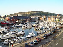
The Swansea barrage is a structure near the mouth of the River Tawe in Swansea, Wales. It was completed in 1992, creating a marina which extended the leisure boat facilities already being offered by the former South Dock.
Crymlyn Burrows is an area in Wales to the east of Swansea city centre, and south of Crymlyn Bog. It is bounded by Jersey Marine Beach to the south and the River Neath to the east. The land west of Baldwin's Crescent falls within the City and County of Swansea and from Baldwin's Crescent eastwards falls within Neath Port Talbot. The area northwest of the Fabian Way contains a small settlement at Elba Crescent and Baldwins Crescent, and areas of industry and commerce.
National Cycle Network, Route 43 is part of the National Cycle Network and the Celtic Trail, which connects Swansea with Builth Wells. Most of the route is still awaiting development. As of June 2006, there is a 13-mile section out of Swansea that is open and signed.
Morfa is a district of Swansea, Wales. It straddles the Bon-y-maen and Landore wards and generally covers the eastern part of the district of Landore.

Penarth Marina is both a marina for boats, located in the old Penarth Docks, Wales and also the name generally used to describe the surrounding area of modern housing. The marina is adjacent to the waters of the River Ely and Cardiff Bay, close to the Cardiff Bay Barrage.

SA1 Swansea Waterfront is the marketing name given to the brownfield development area in the northern part of Swansea Docks, Wales. The area lies directly to the southeast of Swansea city centre. It is bordered by the Fabian Way to the north, and includes the Prince of Wales Dock.
Preston Dock is a former maritime dock located on the northern bank of the River Ribble approximately 2.5 km (1.6 mi) west of Preston's city centre in Lancashire, England. It is the location of the Albert Edward Basin which opened in 1892 and is connected to the river by a series of locks.