 | ||||
|---|---|---|---|---|
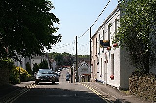
 A4240 Gorseinon Road looking west | ||||
| Major junctions | ||||
| East end | A484 in Loughor | |||
| West end | M4 in Penllergaer | |||
| Location | ||||
| Country | United Kingdom | |||
| Constituent country | Wales | |||
| Road network | ||||
| ||||
| | ||||
|---|---|---|---|---|
| A4240 Gorseinon Road looking west | ||||
| Major junctions | ||||
| East end | A484 in Loughor | |||
| West end | M4 in Penllergaer | |||
| Location | ||||
| Country | United Kingdom | |||
| Constituent country | Wales | |||
| Road network | ||||
| ||||
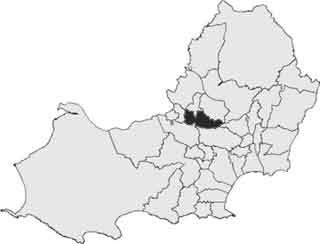
The A4240 begins at the roundabout at the Loughor side of the Loughor bridge. The road heads east through Loughor, then onwards through Gorseinon, where it forms the east–west main road intersecting with the B4296 in central Gorseinon. The A4240 then continues through the Garngoch Industrial Estate and then through Penllergaer after which it continues along a single carriageway shared with the A48 until it reaches the roundabout which forms Junction 47 with the M4 motorway. [2]

The A48 is a trunk road in Great Britain running from the A40 at Highnam, 3 miles (4.8 km) west of Gloucester, England, to the A40 at Carmarthen, Wales. Before the Severn Bridge opened on 8 September 1966, it was a major route between England and South Wales. For most of its route, it runs almost parallel to the M4 motorway. During times of high winds at the Severn Bridge, the A48 is used as part of the diversion route and is still marked as a Holiday Route.

Gorseinon is a town within the City and County of Swansea, Wales, near the Loughor estuary. It was a small village until the late 19th century when it grew around the coal mining and tinplate industries. It is situated in the north west of Swansea City Centre, around 6 miles (10 km) north west of the city centre. Gorseinon is a local government community with an elected town council.
Gower is a constituency created in 1885 and represented in the House of Commons of the UK Parliament by one Member of Parliament (MP). Tonia Antoniazzi of the Labour Party became its MP after winning it from Conservative Byron Davies in the 2017 UK general election. Her party had previously represented the seat from 1909 until 2015.
Gowerton is a large village and community, about 4 miles (6 km) north west of Swansea city centre, Wales. Gowerton is often known as the gateway to the Gower Peninsula. Gowerton's original name was Ffosfelin. The village falls within the Gowerton electoral ward of the City and County of Swansea Council, which elects one councillor. The community had a population of 5,212. and the built-up area with Waunarlwydd 8,183.
Penllergaer is a village and community in the City and County of Swansea, Wales. It lies to the east of Gorseinon, within the electoral ward of the same name. It is situated about 4.5 miles north west of Swansea city centre, near junction 47 of the M4 motorway. The population of the community and ward was 2,868 in 2011.
Penyrheol is the name of an electoral ward and a suburb in the City and County of Swansea, Wales, UK.

Lliw Valley was a local government district with borough status in West Glamorgan, Wales from 1974 to 1996.
Llwchwr is a community and electoral ward in the central western part of the City and County of Swansea, Wales, UK. It lies 9 km west-north-west of Swansea city centre and is bounded by the communities of Gorseinon to the north, Penllergaer to the east, and Gowerton to the south, as well as by the estuary of the River Loughor to the west, on the far side of which lies Bynea in Carmarthenshire, connected to Llwchwr by road and rail bridges.

The A4232, which is also known either as the Peripheral Distributor Road (PDR) (Welsh: Ffordd Ddosbarthu Ymylol) or the Cardiff Link Road (Welsh: Ffordd Gyswllt Caerdydd), is a distributor road in Cardiff, the capital of Wales.
The A4107 road is an A road in Neath Port Talbot County Borough, Wales. It begins in Port Talbot and heads up the Afan Valley in a north easterly direction. It then continues over the moors eastwards until it connects with the A4061 road south west of Treorchy in the Rhondda Valley.

Gorseinon is the name of an electoral ward in the City and County of Swansea, Wales.

The A4230 is a suburban main road in south Wales.

The A4241 Port Talbot Peripheral Distributor Road is a distributor road serving Port Talbot, Wales.

The A4060, also known as the East of Abercynon to East of Dowlais Trunk Road, is a trunk road in Wales.

Penllergaer is the name of an electoral ward in the City and County of Swansea, Wales, UK. Penllergaer has its own elected community council.
Kingsbridge was an electoral ward in the City and County of Swansea, Wales. It was part of the Llwchwr Town council area.
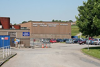
Penyrheol Comprehensive School is a secondary school in Gorseinon, Swansea, Wales.
A roads in Zone 4 of the Great Britain road numbering scheme | ||
|---|---|---|
| ||
| ||
| History |  | ||||||||||||||||
|---|---|---|---|---|---|---|---|---|---|---|---|---|---|---|---|---|---|
| Politics |
| ||||||||||||||||
| Communities |
| ||||||||||||||||
| Culture | |||||||||||||||||
| Education | |||||||||||||||||
| Sports | |||||||||||||||||
| Buildings | |||||||||||||||||
| Transport |
| ||||||||||||||||