
The Bakerloo line is a London Underground line that runs from Harrow & Wealdstone in suburban north-west London to Elephant & Castle in south London, via the West End. Printed in brown on the Tube map, it serves 25 stations, 15 of which are underground, over 23.2 kilometres (14.4 mi). It runs partly on the surface and partly through deep-level tube tunnels.

Kenton is a district in north-west London, England, to the east of Harrow and historically in Middlesex. As with surroundings in Harrow, Wembley and Kingsbury, the area was a product of Metroland suburbia of the early 20th century. Both the London and North Western Railway and Metropolitan Railway reached the area by the 1920s. The main road through Kenton, the east-west Kenton Road, is a busy and important road that links Harrow to the major Edgware Road. The road now forms the boundary between the London boroughs of Harrow and Brent.

Keston is a village in Greater London, England, located within the London Borough of Bromley, Greater London. Prior to 1965 it was within the historic county of Kent. It is part suburban, part rural in nature and lies on the edge of Hayes Common, just beyond the London conurbation to the south of Bromley Common. It includes the small hamlet of Nash to the southwest. The northern, more suburban part of Keston is sometimes referred to as Keston Mark.

Northwood is an area in the London Borough of Hillingdon, North West London, located 14.5 miles (23.3 km) north-west of Charing Cross. Northwood was part of the ancient parish of Ruislip, Middlesex. The area was situated on the historic Middlesex boundary with Hertfordshire, and since being incorporated into Greater London in 1965, has been on the Greater London boundary with that county.

Wembley is a large suburb in the London Borough of Brent, north-west London, 8 miles (13 km) northwest of Charing Cross. It includes the neighbourhoods of Alperton, Kenton, North Wembley, Preston, Sudbury, Tokyngton and Wembley Park. The population was 102,856 in 2011.
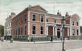
Paddington was a civil parish and metropolitan borough in London, England. It was an ancient parish in the county of Middlesex, governed by an administrative vestry. The parish was included in the area of responsibility of the Metropolitan Board of Works in 1855 and became part of the County of London in 1889. The parish of Paddington became a metropolitan borough in 1900, following the London Government Act 1899, with the parish vestry replaced by a borough council. In 1965 the borough was abolished and its former area became part of the City of Westminster in Greater London.

Harrow is a large town in Greater London, England, and serves as the principal settlement of the London Borough of Harrow. Lying about 9.5 miles (15.3 km) north-west of Charing Cross and 5.4 miles (8.7 km) south of Watford, the entire town including its localities had a population of 149,246 at the 2011 census, whereas the wider borough had a population of 250,149.
Harrow East is a constituency in Greater London created in 1945 and represented in the House of Commons of the UK Parliament since 2010 by Bob Blackman, a Conservative.

St Pancras Church is a Greek Revival church in St Pancras, London, built in 1819–22 to the designs of William and Henry William Inwood. The church is one of the most important 19th-century churches in England and is a Grade I listed building.

Stanmore Village railway station was a station in Stanmore, Middlesex in the south of England. Originally called simply Stanmore, it was opened on 18 December 1890 by the Harrow and Stanmore Railway, a company owned by the hotel millionaire Frederick Gordon, as the terminus of the Stanmore branch line, a short branch line running north from Harrow & Wealdstone. Trains were operated by the London & North Western Railway (LNWR).

Wembley was an urban district and later a municipal borough in Middlesex, England from 1894 to 1965.

St Mary's Church, Charing Cross Road, was an Anglican church in Charing Cross Road, Westminster, from 1851. The building was formerly the site of an ancient church, called 'The Greek Church', and St Mary's was never fully built, with only the chancel and the north aisle being completed. The structure was demolished in the 1930s.
Roxeth was a hamlet in the ancient Harrow on the Hill parish, which now forms part of the London Borough of Harrow in Greater London, England.

Rogers Family Stadium is a football stadium in Harrow, north-west London, England. It is the home ground of Harrow Borough F.C. The stadium has a capacity of 3,070 people, which includes 350 seats and standing under cover for 1,000 people. The record attendance is 3000 for an FA Cup match against local rivals Wealdstone FC in 1946.
Greenhill was an ecclesiastical parish and present day ward with similar but not identical boundaries in the London Borough of Harrow.

Northwick Park is a large green public park between Harrow and Kenton in north-west London, forming part of the London Borough of Brent. Most of the park consists of playing fields. It is also the name of the electoral ward of Brent that covers the park, the area around its namesake station, and most of North Wembley. The park lies in between Northwick Park station and South Kenton station station with the former being at the north-end of the park and the latter in the south-end.

Kenton is a village and civil parish in the Mid Suffolk district of Suffolk in eastern England. Located 1.9 miles to the north-east of Debenham, in 2005 its population was 170. The parish was formerly an exclave of the Loes Hundred one of the Hundreds of Suffolk.

College Park is a small mainly residential neighbourhood in Kensal Green, to the north of the borough of Hammersmith and Fulham, London and is near Kensal Green station and Willesden Junction station. It borders the London Borough of Brent to the north and the Royal Borough of Kensington and Chelsea to the east. It is part of College Park & Old Oak wards of the United Kingdom.

St John the Baptist, Pinner, is an Anglican church in Church Lane, Pinner, Middlesex.

Masbro Road is in the London Borough of Hammersmith, England. It runs from Sinclair Road in the north to Blythe Road in the south. It is joined on the west side by Fielding Road, Irving Road, Redan Street, and Springvale Terrace. It is joined on the east side by Hofland Road and crossed by Milson Road.

