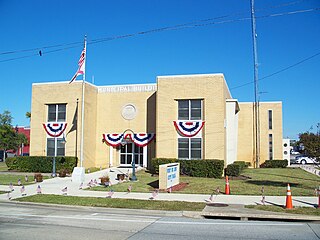
Port St. Joe is a city located at the intersection of U.S. Highway 98 and State Road 71 and the county seat of Gulf County, Florida. As of the 2020 census,the population was 3,357. This was a decline from 3,644 as of the 2000 census.

The Chesapeake & Delaware Canal is a 14-mile (22.5 km)-long, 450-foot (137.2 m)-wide and 35-foot (10.7 m)-deep ship canal that connects the Delaware River with the Chesapeake Bay in the states of Delaware and Maryland in the United States.
King's Highway 58, commonly referred to as Highway 58, is a provincially maintained highway in the Canadian province of Ontario. The route is divided into two segments with a combined length of 15.5 km (9.6 mi). The southern segment travels from Niagara Regional Road 3, formerly Highway 3, in Port Colborne, to the Highway 58A junction in the southern end of Welland, a distance of 7.2 km (4.5 mi). The northern segment begins at Highway 20 near Allanburg and travels north and west to a large junction with Highway 406 at the St. Catharines – Thorold boundary, a distance of 8.3 km (5.2 mi). An 18.1 km (11.2 mi) gap separates the two segments within Welland and Pelham. The entire route is located within the Regional Municipality of Niagara.

State Highway 121 is a state highway angling from southwest to northeast through north central Texas. It runs from downtown Fort Worth, Texas at the junction of Interstate 35W to Bonham, Texas, just north of a junction with U.S. Highway 82.
Contraflow lane reversal is the altering of the normal flow of traffic, typically on a controlled-access highway, to either aid in an emergency evacuation or, as part of routine maintenance activities, to facilitate widening or reconstruction of one of the highway's carriageways.

State Highway 9 (SH 9) is a highway near Copperas Cove, Texas. It connects Interstate 14 (I-14), U.S. Route 190 (US 190), and U.S. Highway 190 Business outside of Copperas Cove to Farm to Market Road 116 (FM 116) on the north side of Copperas Cove. The highway opened on February 20, 2014 with a ribbon cutting at 2:00 PM.

The Industrial Canal is a 5.5 mile (9 km) waterway in New Orleans, Louisiana, United States. The waterway's proper name, as used by the U.S. Army Corps of Engineers and on NOAA nautical charts, is Inner Harbor Navigation Canal (IHNC). The more common "Industrial Canal" name is used locally, both by commercial mariners and by landside residents.
The Oswego Canal is a canal in the New York State Canal System located in New York, United States. Opened in 1828, it is 23.7 miles (38.1 km) in length, and connects the Erie Canal at Three Rivers to Lake Ontario at Oswego. The canal has a depth of 14 ft, with seven locks spanning the 118 ft change in elevation.

The Houston Ship Channel, in Houston, Texas, is part of the Port of Houston, one of the busiest seaports in the world. The channel is the conduit for ocean-going vessels between Houston-area terminals and the Gulf of Mexico, and it serves an increasing volume of inland barge traffic.

The Port of Beaumont is a deep-water port located in Beaumont, Texas near the mouth of the Neches River.

State Highway 48 runs from Brownsville to Port Isabel in Deep South Texas.

State Highway 44 (SH 44) is a Texas state highway that runs from west of Encinal to Corpus Christi, Texas. This highway is also known as the Cesar Chavez Memorial Highway outside the city limits of Robstown, Banquete, Agua Dulce, Alice, and Corpus Christi in Nueces and Jim Hogg counties.

The Port of New York and New Jersey is the port district of the New York-Newark metropolitan area, encompassing the region within approximately a 25-mile (40 km) radius of the Statue of Liberty National Monument. It includes the system of navigable waterways in the New York–New Jersey Harbor Estuary, which runs along over 770 miles (1,240 km) of shoreline in the vicinity of New York City and northeastern New Jersey, as well as the region's airports and supporting rail and roadway distribution networks. Considered one of the largest natural harbors in the world, the port has become the second busiest port by tonnage in the United States as of 2019, and the busiest on the East Coast.

State Highway 73 (SH 73) is a Texas state highway that runs 42 miles (68 km) from Winnie through Port Arthur to near Orange.

The McClellan–Kerr Arkansas River Navigation System (MKARNS) is part of the United States inland waterway system originating at the Tulsa Port of Catoosa and running southeast through Oklahoma and Arkansas to the Mississippi River. The total length of the system is 445 miles (716 km). It was named for two senators, Robert S. Kerr (D-OK) and John L. McClellan (D-AR), who pushed its authorizing legislation through Congress. The system officially opened on June 5, 1971. President Richard M. Nixon attended the opening ceremony. It is operated by the Army Corps of Engineers (USACE).
La Entrada al Pacífico is a trade corridor designated as "Trade Corridor 56" by the Intermodal Surface Transportation Efficiency Act. The corridor is an international project between Mexico and the United States as a route from the Pacific Ocean port of Topolobampo in the Mexican state of Sinaloa to the U.S. state of Texas and beyond by way of the Midland-Odessa area. There is also a proposed upgrade of the rail connection, which might be easier by not requiring the addition of new bridges and tunnels in the Barranca de Cobre region. Its canyons are comparable in depth to the Grand Canyon in the United States.
The Ports-To-Plains Corridor, also known as National Highway System High Priority Corridor 38, is a highway corridor between the United States Mexico border at Laredo, Texas and Denver, Colorado. It is the southern third of the Ports-to-Plains Alliance. The reason for proposed improvements to this corridor is to expedite the transportation of goods and services from Mexico in the United States and vice versa. The Ports-To-Plains Corridor starts in South Texas and traverses through Texas, New Mexico, Oklahoma, and ends in Denver, Colorado.
The Virginia Port Authority (VPA) is an autonomous agency of the Commonwealth of Virginia that owns The Port of Virginia, a group of facilities with their activity centered on the harbor of Hampton Roads, Virginia.

Interstate 169 (I-169) is an auxiliary route of I-69E in Texas that currently runs from I-69E in Brownsville southeast concurrently with State Highway 550 (SH 550), a toll road under construction that connects to the Port of Brownsville for 1.5 miles (2.4 km). When SH 550 is complete, it will be a limited-access toll route around the northern and eastern edges of Brownsville and signed as I-169, partly replacing and expanding Farm to Market Road 511 (FM 511). Its purpose is to provide a new entry point for truck traffic to the Port of Brownsville and forming a loop that allows traffic to bypass the northern sections of the urbanized extent of the Brownsville city limits. This may serve as a relief route for future traffic congestion and as a future business corridor.
The Jefferson Seaway was a proposed deep-draft ship channel to be created in Jefferson Parish, Louisiana, that would establish a route between the Mississippi River at Westwego and the Gulf of Mexico near Grand Isle. The Mississippi River provided the only deep-water access to New Orleans and its neighboring ports. In the mid-20th century, the creation of alternate routes was considered, including the Mississippi River-Gulf Outlet (MR-GO), which was ultimately selected, funded and constructed. The Jefferson Seaway, sometimes referred to as the Arrow to the Americas, the Mississippi Valley Seaway Canal, the Tidewater Ship Canal and the Barataria Canal, was also under consideration but ultimately was never constructed as a deep-draft channel.


