The Neches River begins in Van Zandt County west of Rhine Lake and flows for 416 miles (669 km) through the piney woods of east Texas, defining the boundaries of 14 counties on its way to its mouth on Sabine Lake near the Rainbow Bridge. Two major reservoirs, Lake Palestine and B. A. Steinhagen Reservoir are located on the Neches. The Angelina River is a major tributary with its confluence at the north of Lake B. A. Steinhagen. Tributaries to the south include Village Creek and Pine Island Bayou, draining much of the Big Thicket region, both joining the Neches a few miles north of Beaumont. Towns and cities located along the river including Tyler, Lufkin, and Silsbee, although significant portions of the Neches River are undeveloped and flow through protected natural lands. In contrast, the lower 40 miles of the river are a major shipping channel, highly industrialized, with a number of cities and towns concentrated in the area including Beaumont, Vidor, Port Neches, Nederland, Groves, and Port Arthur.
Jefferson County is a county in the Coastal Plain or Gulf Prairie region of Southeast Texas. The Neches River forms its northeast boundary. As of the 2020 census, the population was 256,526. The county seat is Beaumont. Jefferson County has the highest percentage of African Americans in the state of Texas.

Port Arthur is a city in the U.S. state of Texas, 90 mi (140 km) east of Houston. Part of the Beaumont–Port Arthur metropolitan area, Port Arthur lies primarily in Jefferson County, with a small, uninhabited extension in Orange County. The largest oil refinery in the United States, the Motiva Refinery, is located there.

The Intracoastal Waterway (ICW) is a 3,000-mile (4,800 km) inland waterway along the Atlantic and Gulf of Mexico coasts of the United States, running from Massachusetts southward along the Atlantic Seaboard and around the southern tip of Florida, then following the Gulf Coast to Brownsville, Texas. Some sections of the waterway consist of natural inlets, saltwater rivers, bays, and sounds, while others are artificial canals. It provides a navigable route along its length without many of the hazards of travel on the open sea.

The Gulf Intracoastal Waterway (GIWW) is the portion of the Intracoastal Waterway located along the Gulf Coast of the United States. It is a navigable inland waterway running approximately 1,300 mi (2,100 km) from Saint Marks, Florida, to Brownsville, Texas.
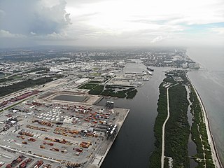
The Port of Houston is one of the world's largest ports and serves the metropolitan area of Houston, Texas. The port is a 50-mile-long complex of diversified public and private facilities located a few hours' sailing time from the Gulf of Mexico. Located in the fourth-largest city in the United States, it is the busiest port in the U.S. in terms of foreign tonnage and the busiest in the U.S. in terms of overall tonnage. Though originally the port's terminals were primarily within the Houston city limits, the port has expanded to such a degree that today it has facilities in multiple communities in the surrounding area. In particular the port's busiest terminal, the Barbours Cut Terminal, is located in Morgan's Point.

Sabine Lake is a bay on the Gulf coasts of Texas and Louisiana, located approximately 90 miles (140 km) east of Houston and 160 miles (260 km) west of Baton Rouge, adjoining the city of Port Arthur. The lake is formed by the confluence of the Neches and Sabine Rivers and connects to the Gulf of Mexico through Sabine Pass. It forms part of the Texas–Louisiana border, falling within Jefferson and Orange Counties in Texas and Cameron Parish, Louisiana.

Sabine Pass is the natural outlet of Sabine Lake into the Gulf of Mexico. It borders Jefferson County, Texas, and Cameron Parish, Louisiana.
Port Everglades is a seaport in Fort Lauderdale, Florida, located in Broward County. Port Everglades is one of South Florida's foremost economic engines, as it is the gateway for both international trade and cruise vacations. In 2022, Port Everglades was ranked the third-busiest cruise homeport, accommodating more than 1.72 million passengers. Port Everglades' cargo sector has been climbed up the rankings based on its operational performance among 348 seaports in the world.

The Port of Oakland is a major container ship facility located in Oakland, California, in the San Francisco Bay. It was the first major port on the Pacific Coast of the United States to build terminals for container ships. As of 2019 it was the sixth busiest container port in the United States, behind Long Beach, Los Angeles, Newark, Port of Seattle-Tacoma, and Savannah,. Development of an intermodal container handling system in 2002 after over a decade of planning and construction positions the Port of Oakland for further expansion of the West Coast freight market share. In 2019 it ranked 8th in the United States in the category of containers.

The Rainbow Bridge is a through truss bridge crossing the Neches River in Southeast Texas just upstream from Sabine Lake. It allows State Highway 87 and State Highway 73 to connect Port Arthur in Jefferson County on the southwest bank of the river. Bridge City in Orange County is on the northeast bank.

The inland waterways of the United States include more than 25,000 mi (40,000 km) of navigable waters. Much of the commercially important waterways of the United States consist of the Mississippi River System—the Mississippi River and connecting waterways.
The Port of Lake Charles is an industrial port based in the city of Lake Charles, Louisiana, U.S.A. It is a major employer in Lake Charles. It is the twelfth-busiest port in the United States according to the American Association of Port Authorities U.S. Port Ranking by Cargo Tonnage, 2013 report and the 83rd-busiest in the world in terms of tonnage according to the American Association of Port Authorities World Port Rankings 2013 report. The Calcasieu Ship Channel provides direct access to the Gulf of Mexico, 34 miles downstream from the city docks. The ship channel intersects the Gulf Intracoastal Waterway just north of Calcasieu Lake. The Ship Channel has a project depth of 40 feet and a bottom width of 400 feet.

The Charleston Harbor is an inlet of the Atlantic Ocean at Charleston, South Carolina. The inlet is formed by the junction of Ashley and Cooper rivers at 32°49′7.10″N79°55′40.41″W. Morris and Sullivan's Islands shelter the entrance. Charleston Harbor forms part of the Intracoastal Waterway.
Port Freeport is the smallest (geographically) deep-water seaport along the U.S Gulf Coast. Located in Freeport, Texas . It has rail access, represents both private and public facilities. It is ranked 10th in the nation for chemicals, 19th in the nation for total tonnage, 26th in the nation for container traffic, handles over 100,000 vehicles per year and has more than 1,000 ships per year. Forbes magazine (2017) ranked Port Freeport as one of the top 10 fastest growing seaports for exports in the U.S.

The Port of Port Arthur is a seaport in Port Arthur, Texas.
The Port of Corpus Christi is the largest port in the United States in total revenue tonnage, third largest in total waterway tonnage, and the largest crude oil export gateway in the nation. The Port of Corpus Christi is located on Corpus Christi Bay in the western Gulf of Mexico, with a 36-mile channel that is being widened and deepened to 54 feet MLLW from its current depth of 45 feet.

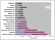
The Sabine–Neches Waterway is located in southeast Texas and Calcasieu Parish, Louisiana, United States. The waterway includes parts of the Neches River, Sabine River, Sabine Lake, and Taylor Bayou. The waterway ranks as third-busiest waterway in the U.S. in terms of cargo tonnage, according to the American Association of Port Authorities. It also ranks as the top bulk liquid cargo waterway, the top U.S. crude-oil importer, and is projected to become the largest LNG exporter in the United States. The Gulf Intracoastal Waterway crosses the waterway near Port Arthur.

The U.S. state of Texas has a series of estuaries along its coast on the Gulf of Mexico, most of them bounded by the Texas barrier islands. Estuaries are coastal bodies of water in which freshwater from rivers mixes with saltwater from the sea. Twenty-one drainage basins terminate along the Texas coastline, forming a chain of seven major and five minor estuaries: listed from southwest to northeast, these are the Rio Grande Estuary, Laguna Madre, the Nueces Estuary, the Mission–Aransas Estuary, the Guadalupe Estuary, the Colorado–Lavaca Estuary, East Matagorda Bay, the San Bernard River and Cedar Lakes Estuary, the Brazos River Estuary, Christmas Bay, the Trinity–San Jacinto Estuary, and the Sabine–Neches Estuary. Each estuary is named for its one or two chief contributing rivers, excepting Laguna Madre, East Matagorda Bay, and Christmas Bay, which have no major river sources. The estuaries are also sometimes referred to by the names of their respective primary or central water bodies, though each also includes smaller secondary bays, inlets, or other marginal water bodies.