
Jim Wells County is a county in the U.S. state of Texas. As of the 2020 census, its population was 38,891. The county was founded in 1911 and is named for James B. Wells Jr. (1850–1923), for three decades a judge and Democratic Party political boss in South Texas.
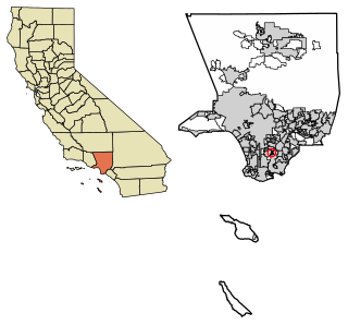
East Rancho Dominguez, also known as East Compton, is an unincorporated community and census-designated place (CDP) located in southern Los Angeles County, California. The population was 15,135 at the 2010 census, up from 9,286 at the 2000 census. East Rancho Dominguez is an accepted city name according to the USPS, and shares the 90221 ZIP Code with Compton.

West Rancho Dominguez, formerly known as West Compton and also known as East Gardena, is an unincorporated census-designated place (CDP) located in southern Los Angeles County, California. Per the 2020 census, the population was 24,347. The community lies to the west of the city of Compton. The ZIP Codes encompassing the CDP area are 90220 & 90248.
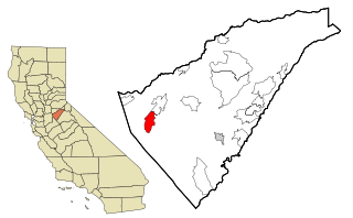
Rancho Calaveras is a census-designated place (CDP) in Calaveras County, California, United States. The population was 5,325 at the 2010 census, up from 4,182 at the 2000 census.

Gardnerville Ranchos is a census-designated place in Douglas County, Nevada, United States. As of the 2010 census, the population was 11,312. The area is the namesake for the Gardnerville Ranchos Micropolitan Statistical area which includes other areas of Douglas County.
Stottville is a hamlet and census-designated place (CDP) in Columbia County, New York, United States. The population was 1,375 at the 2010 census.

Guerra is an unincorporated community and census-designated place (CDP) in Jim Hogg County, Texas, United States. The population was six as of the 2010 Census, giving it the distinction of being the smallest town by population in Texas.

Las Lomitas is an unincorporated community and census-designated place (CDP) in Jim Hogg County, Texas, United States. The population was 244 at the 2010 census.

South Fork Estates is a census-designated place (CDP) in Jim Hogg County, Texas, United States. The population was 70 at the 2010 census, up from 47 at the 2000 census.

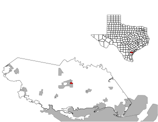
Alice Acres is a census-designated place (CDP) in Jim Wells County, Texas, United States. The population was 465 at the 2020 census.

Coyote Acres is a census-designated place (CDP) in Jim Wells County, Texas, United States. The population was 570 at the 2020 census, up from 508 at the 2010 census.
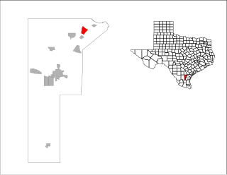
K-Bar Ranch is a census-designated place (CDP) in Jim Wells County, Texas, United States. The population was 375 at the 2020 census.

Loma Linda East is a census-designated place (CDP) in Jim Wells County, Texas, United States. The population was 305 at the 2020 census, up from 254 at the 2010 census.

Owl Ranch-Amargosa is a census-designated place (CDP) in Jim Wells County, Texas, United States. The population was 527 at the 2000 census. The area is widely referred to as "Tecolote", the Spanish term for "owl".

Rancho Banquete is a census-designated place (CDP) in Nueces County, Texas, United States. The population was 459 at the 2020 census, down from 424 at the 2010 census.
Rancho Chico is a census-designated place (CDP) in San Patricio County, Texas, United States. The population was 387 at the 2020 census.
El Refugio is a census-designated place (CDP) in Starr County, Texas, United States. The population was 407 at the 2020 census. El Refugio gained area in the 2010 census.

La Victoria is a census-designated place (CDP) in Starr County, Texas, United States. La Victoria underwent some changes prior to the 2010 census. It gained area, had portions taken to form new CDPs, and lost additional area. Only a small part of 2010 La Victoria CDP was within the 2000 La Victoria CDP. The population was only 171 at the 2010 census, a decline from the figure of 1,683 tabulated at the 2000 census.

Ranchos Penitas West is a census-designated place (CDP) in Webb County, Texas, United States. The population was 466 at the 2020 census.
Howland is a census-designated place (CDP) in Penobscot County, Maine, United States. The population was 1,096 at the 2010 census.

