Secondary city

Last updated
Pokhara, a secondary city in Nepal, is the capital of Gandaki Province. It is a major tourist center for mountain trekking. City of Pokhara.jpg
Pokhara, a secondary city in Nepal, is the capital of Gandaki Province. It is a major tourist center for mountain trekking.

A secondary city is an urban hub that fills specific regional and local needs related to governance, economics, finance, education, trade, transportation. A secondary city is defined by population, area, function, and economic status, but also by their relationship to neighboring and distant cities and their socio-economic status. A secondary city may emerge from a cluster of smaller cities in a metropolitan region or may be the capital city of a province, state, or second-tier administrative unit within a country. Secondary cities are the fastest growing urban areas in lower and middle income countries, experiencing unplanned growth and development. By 2030, there will be twice as many medium size cities as there were in 1990, outnumbering the total number of megacities. [1] According to the World Bank, secondary cities make up almost 40% of the world cities population. [2] Many secondary cities in the Global South are expected to undergo massive expansions in the next few decades comparable to city growth in Europe and North America over the past two centuries. [3] These cities are unique environments that generally have limited data and information on infrastructure, land tenure, and planning.

Contents

Secondary city vs megacities

Secondary cities are often eclipsed by megacities that dominate urbanization programs due to their size and influence. However, secondary cities represent a larger percentage of the urban population worldwide and there are many more secondary cities than megacities. For example, in sub-Saharan Africa secondary cities are experiencing more than fifty percent of the continent's urban growth. [4] The U.N. World Urbanization Prospects 2018 [1] note that approximately only seven percent of the world's population live in megacities of 10 million or more. [5]

Secondary cities have their own socio-economic and political culture that differ from megacities. They have more land, are less developed, and offer more opportunities for investment, adaptation, and improvisation. These cities are important emerging centers of economic activity that relieve the pressures of migration to megacities. [6] [7] While the large cities play a significant role in shaping the economic geography of cities in fostering global trade, travel and investment, it is secondary cities which will have a much stronger influence in the future upon the economic development of countries. [8]

The rapid growth of secondary cities and general lack of infrastructure, particularly in lower and middle income countries, make these cities prime locations for urban sprawl and informal settlements with inadequate basic services. According to UN-HABITAT, "slum population now expands annually by 25 million." [9] Countries like India are developing secondary cities to absorb informal dwellers—as India's chief economic planner, Montek singh Ahluwalia in 2007, observes: "One hundred million people are moving to cities in the next 10 years, and it’s important that these 100 million are absorbed into second-tier cities instead of showing up in Delhi or Mumbai." [10]

Characteristics of a secondary city

Battambang Battambang city.jpg
Battambang

Secondary cities are difficult to define and vary from country to country and amongst the variety of urban reporting tools such as the U.N. World Urbanization Prospects and the Atlas of Urban Expansion. Secondary cities reflect their countries' demographic and geographic characteristics. The population of a secondary city may range from 10-50% of the country’s largest city, although some may be smaller than this. [11] Population is a measure of the urban scale but does not reflect the role and function of the city. For example, while a secondary city in Costa Rica will have significant population differences from a secondary city in China, their functional roles may be similar.

Secondary cities can be characterized into three general categories: sub-national functional centers (i.e., provincial capital, industry center, university hub, tourist attraction); city clusters or satellite urban areas surrounding a larger metropolitan region; and an economic trade corridor developing along major transportation routes. [8] These categories define the regional importance of secondary cities and their linkages to the surrounding hinterland and rural areas. Secondary cities have a diffuse genealogy creating a hybrid, socio-cultural urban dynamic often in contrast to larger urban areas. [12] The secondary city is a location for improvisation and innovation. Local patterns of commerce, the interactions of civil society, and decentralized political activities in secondary cities reflect a shifting economies, changing stakeholder alliances, and adaptive governance structures. [13]

Climate resilience and secondary cities

Climate change and cities are at the forefront of urban development and investment in the 21st Century. Secondary cities are an emerging arena in which to devise climate change initiatives. These adaptations include initiatives specifically focused on new immigrants and vulnerable populations (i.e., the elderly, children, women), expanding informal settlements and the need for strategies for access to basic services (i.e., electricity, water, community gardens), urban zoning to enhance green spaces (i.e., tree planting, riparian restoration), and building designs and materials to create structures that reflect the seasonal changes caused by climate change (i.e., access to air conditioning; adequate heating facilities).  

Secondary cities around the world

Secondary cities are found in all parts of the world, however, nearly two-thirds of secondary cities are located in Asia and Africa. These secondary cities reflect the specific geography of the countries in which they are found. While Asian countries are very diverse, secondary cities within these countries are distinct. For example, China's secondary cities are very different from Indonesia's secondary cities. China's second and third-level cities are locations where private sector global expansion occurs that include top hotel companies, increased domestic travel via train and air, and international meeting facilities. These secondary cities are part of the global and local economy demonstrating their importance as regional hubs of commerce and transportation. [14] Indonesia's secondary cities have experienced rapid growth and expansion. Greater Surabaya is illustrative of patterns of suburban expansion supporting industrial development and facilitating commuter culture to the urban center. The rapid urban expansion has resulted in extensive informal settlements with inadequate infrastructure (i.e., electricity) and limited access to basic services (i.e., water supply). [15]

African secondary cities host 80% of the continent's urban population outside of the largest urban agglomerations and has over 70 cities with greater than 1 million inhabitants. [16] These rapidly growing urban areas attract rural migrants who move into informal settlements without basic amenities, high levels of pollution, loss of biodiversity, and poor sanitation. [17] However, economic development and infrastructure improvements have largely been concentrated in capital cities many of which are megacities such as Nairobi, Kenya, Lagos, Nigeria, and Kampala, Uganda. Global evidence suggests that secondary cities provide better opportunities for poverty reduction as well as relieving population pressures on larger cities. [18] Examples of African secondary cities include Pemba, Mozambique; Boke-Kamsar, Guinea; and Mekelle, Ethiopia. Both Pemba and Kamsar are port cities that provide important trade services for economic development. Boke-Kamsar is a rapidly expanding urban corridor for coastal trade and inland mining intersect. [19] Mekelle, Ethiopia is the provincial capital of Tigray and the center of regional conflict (2020 - 2022) and staging area for provisioning of food and resources.

Latin American secondary cities are locations of economic and social development. According to the Development Bank of Latin America, these urban areas are home to 32% of Latin Americans and are estimated to include 17% of GDP. [20] In Latin America, where primary cities long monopolized growth, secondary cities like Tijuana, Curitiba, Temuco, Salvador and Belém are booming, "with the fastest growth of all occurring cities with between 100,000 and 500,000 inhabitants." [21]

The future of secondary cities

In the future, secondary cities will have a strong influence on the economic development of countries. [8] While the importance of secondary cities is increasingly recognised, growing inequalities are emerging between systems of cities and regions, with metropolitan areas often prospering at the expense of smaller cities and rural areas. Secondary cities are areas where experimental strategies and innovative planning can be tested.

Networks are critical to improving the level of communications, exchange and movement among systems of secondary cities. Many networks will require investment in hard infrastructure, such as transport and communications, and soft infrastructure to facilitate greater economic, social, cultural and governance exchange. This involves building city, industry and firm partnerships, as well as collaborative governance and economic development. Collaboration is vital to finance hard and soft strategic infrastructure, through arrangements to share revenue as well as development, operating and maintenance costs. If enhanced connectivity is to be used as a strategy to support the economic development of secondary cities, policy makers must understand the need for integration of hard and soft connectivity elements, and how governments can facilitate their development. [22] If the efficiency of secondary cities were to improve this could increase the GDP of many poor cities and rural regions. [23]

Related Research Articles

<span class="mw-page-title-main">City</span> Large permanent human settlement

A city is a human settlement of a notable size. The term "city" has different meanings around the world and in some places the settlement can be very small. Even where the term is limited to larger settlements, there is no universally agreed definition of the lower boundary for their size. In a more narrow sense, a city can be defined as a permanent and densely settled place with administratively defined boundaries whose members work primarily on non-agricultural tasks. Cities generally have extensive systems for housing, transportation, sanitation, utilities, land use, production of goods, and communication. Their density facilitates interaction between people, government organizations, and businesses, sometimes benefiting different parties in the process, such as improving the efficiency of goods and service distribution.

<span class="mw-page-title-main">Megacity</span> Metropolitan area with a total population in excess of ten million people

A megacity is a very large city, typically with a population of more than 10 million people. The United Nations Department of Economic and Social Affairs in its 2018 "World Urbanization Prospects" report defines megacities as urban agglomerations with over 10 million inhabitants. A University of Bonn report holds that they are "usually defined as metropolitan areas with a total population of 10 million or more people". Elsewhere in other sources, from five to eight million is considered the minimum threshold, alongside a population density of at least 2,000 per square kilometre. The terms conurbation, metropolis, and metroplex are also applied to the latter.

<span class="mw-page-title-main">Urbanization</span> Process of population movement to cities

Urbanization is the population shift from rural to urban areas, the corresponding decrease in the proportion of people living in rural areas, and the ways in which societies adapt to this change. It can also mean population growth in urban areas instead of rural ones. It is predominantly the process by which towns and cities are formed and become larger as more people begin living and working in central areas.

<span class="mw-page-title-main">Slum</span> Highly populated urban residential area consisting mostly of decrepit housing units

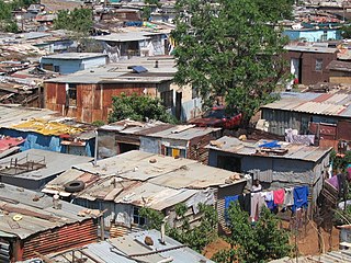
A slum is a highly populated urban residential area consisting of densely packed housing units of weak build quality and often associated with poverty. The infrastructure in slums is often deteriorated or incomplete, and they are primarily inhabited by impoverished people. Although slums are usually located in urban areas, in some countries they can be located in suburban areas where housing quality is low and living conditions are poor. While slums differ in size and other characteristics, most lack reliable sanitation services, supply of clean water, reliable electricity, law enforcement, and other basic services. Slum residences vary from shanty houses to professionally built dwellings which, because of poor-quality construction or lack of basic maintenance, have deteriorated.

<span class="mw-page-title-main">Urban geography</span> Subdiscipline of geography concentrating on urban areas

Urban geography is the subdiscipline of geography that derives from a study of cities and urban processes. Urban geographers and urbanists examine various aspects of urban life and the built environment. Scholars, activists, and the public have participated in, studied, and critiqued flows of economic and natural resources, human and non-human bodies, patterns of development and infrastructure, political and institutional activities, governance, decay and renewal, and notions of socio-spatial inclusions, exclusions, and everyday life. Urban geography includes different other fields in geography such as the physical, social, and economic aspects of urban geography. The physical geography of urban environments is essential to understand why a town is placed in a specific area, and how the conditions in the environment play an important role with regards to whether or not the city successfully develops. Social geography examines societal and cultural values, diversity, and other conditions that relate to people in the cities. Economic geography is important to examine the economic and job flow within the urban population. These various aspects involved in studying urban geography are necessary to better understand the layout and planning involved in the development of urban environments worldwide.

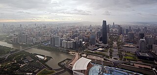
The urbanization of most of Africa is moving fast forward, especially south of the Sahara. It is estimated that in 1900, about 89% of inhabitants lived from the primary occupations of farming, hunting & gathering, cattle nomadism, and fishing meaning that 11% or less were urban. At the start of the independence period in 1957, 14.7% of Africa's inhabitants were urban, in 2000 had it risen to 37.2% and it is expected to rise to 49.3% in 2015, in effect 3.76% to 3.35% per year. In sub-Saharan Africa in 1960 "only one city, Johannesburg, had a population of one million;...in 2009, there were fifty-two cities with such large populations." The Nigerian city of Lagos that in 1963 had 665,000 inhabitants and 8.7 million in 2000 is expected to become the world's 11th biggest city by 2015 with 16 million inhabitants.

<span class="mw-page-title-main">Hammanskraal</span> Region in northern Gauteng province, South Africa

Hammanskraal is a trans-provincial region anchored in northern Gauteng province, South Africa. The region consists of multiple, residential, industrial and commercial areas in a decentralized settlement pattern.

Slum upgrading is an integrated approach that aims to turn around downward trends in an area. These downward trends can be legal, physical (infrastructure), social or economic." The main objective of slum upgrading is to rehabilitate them into functional neighborhoods by addressing the social needs of the community, and improving integration into the formal urban economy.

<span class="mw-page-title-main">Urbanization in China</span> Overview of urbanization in China

Urbanization in China increased in speed following the initiation of the reform and opening policy. By the end of 2023, China had an urbanization rate of 66.2% and is expected to reach 75-80% by 2035.

Shiba Prasad Chatterjee was a Professor of Geography at the University of Calcutta, India. He served as President of the International Geographical Union from 1964 until 1968, Chatterjee received a Murchison Award from the Royal Geographical Society in 1959, and a Padma Bhushan from the Government of India in 1985. He coined the name 'Meghalaya' for one of India's states.

Overurbanization is a thesis originally developed by scholars of demography, geography, ecology, economics, political science, and sociology in thrergence of International Nongovernmental Organizations Amid Declining States. The term is intentionally comparative and has been used to differentiate between developed and developing countries. Several causes have been suggested, but the most common is rural-push and urban-pull factors in addition to population growth.

<span class="mw-page-title-main">Urbanization in India</span> Overview of urbanization in India

Urbanization in India began to accelerate after independence, due to the country's adoption of a mixed economy, which gave rise to the development of the private sector. The population residing in urban areas in India, according to the 1901 census, was 11.4%, increasing to 28.53% by the 2001 census, and is now currently 34% in 2017 according to the World Bank. According to a survey by the United Nations, in 2030 40.76% of country's population is expected to reside in urban areas. As per the World Bank, India, along with China, Indonesia, Nigeria, and the United States, will lead the world's urban population surge by 2050.

Urbanization in Pakistan has increased since the time of independence and has several different causes. The majority of southern Pakistan's population lives along the Indus River. Karachi is its most populous city. In the northern half of the country, most of the population lives in an arc formed by the cities of Lahore, Faisalabad, Rawalpindi, Islamabad, Gujranwala, Sialkot, Gujrat, Jhelum, Sargodha, Sheikhupura, Nowshera, Mardan and Peshawar. During 1990–2008, city dwellers made up 36% of Pakistan's population, making it the most urbanised nation in South Asia. Furthermore, 50% of Pakistanis live in towns of 5,000 people or more.

<span class="mw-page-title-main">Cities Alliance</span>

Cities Alliance is a global partnership fighting urban poverty and supporting cities to deliver sustainable development. To manage its activities, the Cities Alliance operates a multi-donor fund with UN Office for Project Services (UNOPS), as host and trustee. Different members provide direction, financing and advocacy. Cities Alliance aims to deliver solutions to urban poverty.

<span class="mw-page-title-main">Water crisis in the Democratic Republic of the Congo</span> Water crisis

Although the Democratic Republic of the Congo (DRC) has Africa's largest freshwater resources, it is suffering from an acute drinking water supply crisis. The DRC has one of the lowest rates of access to clean drinking water in Sub-Saharan Africa and the world. Only 46 percent of the population had access to an improved drinking water source in 2012. Furthermore, the sanitation coverage was estimated at only 31 percent in 2012. Up to date and accurate information on water supply and sanitation services in the DRC is scarce. As a result of inadequate water supply and sanitation services, many inhabitants are suffering from waterborne diseases, including diarrhoea, typhoid, and cholera.

<span class="mw-page-title-main">Urban rail transit in Africa</span> Overview of Africas urban rail transit system

Urban rail transit in Africa has emerged as a growing form of transit due to rapid urbanization that has occurred in recent decades across the continent. Some of these transit systems are older and more developed, such as the metro in Cairo which opened in 1987. Others such as the light-rail system in Addis Ababa are much more recent, which opened in 2015. A variety of technologies are being used ranging from light-rail, bus rapid-transit, and commuter-rail etc. Africa for several decades saw minimal investment in rail infrastructure, but in recent years due to urban population growth and improved financing options, investment in rail networks has increased.

<span class="mw-page-title-main">Gentrification of Mexico City</span>

Mexico City has massively been expanding its urban fabric and population density, becoming the fifth largest city in the world. A combination of neoliberal policies, complex geographic location, socio-economic disparities and inefficient strategies have influenced the process of gentrification in the city. The combination of numerous megaprojects and inefficient city-planning strategies have led to dysfunctions in circulation, community allocation and equal access to resources. In consequence, middle and low-income communities have been directly or indirectly alienated and challenged to adapt to a complex and evolving urban environment.

<span class="mw-page-title-main">Climate change and cities</span>

Climate change and cities are deeply connected. Cities are one of the greatest contributors and likely best opportunities for addressing climate change. Cities are also one of the most vulnerable parts of the human society to the effects of climate change, and likely one of the most important solutions for reducing the environmental impact of humans. The UN projects that 68% of the world population will live in urban areas by 2050. In the year 2016, 31 mega-cities reported having at least 10 million in their population, 8 of which surpassed 20 million people. However, secondary cities - small to medium size cities are rapidly increasing in number and are some of the fastest growing urbanizing areas in the world further contributing to climate change impacts. Cities have a significant influence on construction and transportation—two of the key contributors to global warming emissions. Moreover, because of processes that create climate conflict and climate refugees, city areas are expected to grow during the next several decades, stressing infrastructure and concentrating more impoverished peoples in cities.

<span class="mw-page-title-main">Abidjan–Lagos Corridor</span> Transborder agglomeration in Africa

The Abidjan–Lagos Corridor, also known as the Abidjan–Lagos Megalopolis, is an emerging transnational megalopolis on the coast of southern West Africa. It stretches from Abidjan to Lagos, crossing five independent states from west to east, and includes two political capitals and many regional economic centers. The corridor has a length of approximately 965 kilometers. Within the megalopolis, a significant portion of West Africa's economic output is generated, and cities within the corridor are among the most economically developed of their respective countries, for which agglomeration effects and access to the Atlantic Ocean are responsible. The population within the region is experiencing rapid growth, and nearly 50 million people are expected to live within the corridor by 2035. According to projections, by the end of the 21st century, the region could become the largest urban region with continuous settlement in the world, then with up to half a billion inhabitants.

Water stress is increasingly affecting urbanization. Water stress arises through slum development, anarchic construction, water scarcity, the absence of financial structures, the absence of basic structures, the absence of infrastructure such as roads, bridges, sidewalks, signs, markets, schools, etc., can sometimes hinder the productivity of certain cities. Unfortunately, this phenomenon affects even the largest cities in the world; in 2018, 300,000 were recorded in the world, housing around 40% of the world's urban population.

References

  1. 1 2 United Nations, Department of Economic and Social Affairs, Population Division (2019). World Urbanization Prospects: The 2018 Revision (ST/ESA/SER.A/420).  New York: United Nations.
  2. Baeumler, Alex; D’Aoust, Olivia; Gapihan, Annie; Goga, Soraya; Lakovits, Carina; Restrepo Cavadid, Paula; Singh, Gayatri; Terraza, Horacio. 2021. Demographic Trends and Urbanization. Washington, DC: World Bank. doi : 10.1596/978-1-4648-1112-9. License: Creative Commons Attribution CC BY 3.0 IGO  
  3. World Bank, Systems of Cities Integrating National and Local Policies Connecting Institutions and Infrastructures. 2009, World Bank: Washington.
  4. Lamson-Hall, Patrick; Shlomo Angel and Tsigereda Tafesse. 2022. Managing Migration and Urban Expansion in Secondary Cities: Planning for Equity and Growth in Future Cities. Cities Alliance/UNOPS: Brussels.
  5. Perry, Gad (October 26, 2020). "Why secondary cities deserve more attention". Newssecuritybeat.
  6. Dennis A. Rondinelli, "Dynamics of Growth of Secondary Cities in Developing Countries". In Geographical Review, American Geographical Society, Vol. 73, No. 1 (Jan., 1983), pp. 42-57.
  7. "Africa's future is in its secondary cities". Devex. 2016-10-11. Retrieved 2023-06-13.
  8. 1 2 3 Roberts B. and Hohmann R. (2014), Secondary Cities: Managing Urban Land Governance Systems. Paper presented at the World Bank and Land Poverty 2014: Uses of Spatial Data in Urban Management
  9. UN Population Division, World urbanization prospects , 2007 Revision, New York 2002.
  10. Anand Giridharadas,"Second Tier’ City to Rise Fast Under India’s Urban Plan", New York Times, May 13, 2007. Accessed September 14, 2014
  11. Roberts, B.H. (2014). Managing Systems of Secondary Cities: Policy Responses in International Development. Brussels, Belgium: Cities Alliance. pp. 24–33. ISBN   978-9-0822617-1-4.
  12. Ann Cassiman, Filip De Boeck, Steven Van Wolputte,(2009, September), Recentering the City: An Anthropology of Secondary Cities in Africa. Institute for Anthropological Research in Africa (IARA), University of Leuven, Belgium.
  13. Dennis A. Rondinelli, "Dynamics of Growth of Secondary Cities in Developing Countries." Geographical Review, American Geographical Society, Vol. 73, No. 1 (Jan., 1983), pp. 42-57.
  14. Wang, Qianyi (2019). "Alternative Globalisations and Role of China's Secondary Cities: Three Case Studeis". China: An International Journal. 17 (3): 95–111 via Project MUSE.
  15. Das, A. & King, R. 2019. Surabaya: The Legacy of Participatory Upgrading of INformal Settlements. World Resources Institute. wrirosscities.org/WRR_Case-STudy_Surabaya_web.pdf
  16. Munro, G. 2022. Secondary Cities are Vital for Africa's Future. World Economic Forum. https://www.weforum.org/agenda/2022/06/africa-secondary-cities-infrastructure
  17. Roberts, B., et. al., 2022. The dynamics of systems of secondary cities in Africa: Urbanisation, migration and development. Cities Alliance. citiesalliance.org/the dynamics of systems of secondary cities in Africa 1.pdf
  18. Christiaensen, L. & Kanbur, R. 2017. Secondary towns and poverty reduction: Refocusing the urbanization agenda. IZA DP No. 10637, March. Institute of Labor Economics. econstor.eu/wps6422.pdf
  19. "Guinea: Boké Bauxite Mine and Infrastructure Project". African Development Bank Group - Making a Difference. 2019-04-11. Retrieved 2023-06-26.
  20. Reyes, M. 2015. Emerging Cities Universe in Latin America. https://blogs.iadb.org/ciudades-sostenibles/en/emerging-cities-universe/#_ftn2
  21. Miguel villa and Jorge Rodriguez, "Demographic trends in Latin America’s metropolises,1950-1990", in Alan Gilbert, The mega-city in Latin America, Tokyo 1996, pp. 33-34
  22. "Introducing Connecting Systems of Secondary Cities | Cities Alliance". www.citiesalliance.org. Retrieved 2019-05-20.
  23. Roberts B. (2014), "System of Secondary Cities: Why they are Important to the Sustainable Development of Nations and Regions", Power Point presentation for the Networking Event: Secondary Cities- Key Links for Equitable and Sustainable City Systems organised by Cities Alliance and IADB at the WUF 7 in Medellin

Further reading

  1. Markusen, Ann R., Yong-Sook Lee, and Sean DiGiovanna. Second Tier Cities: Rapid Growth beyond the Metropolis. Minneapolis: University of Minnesota, 1999. Print.
  2. Davis, Mike. Planet of Slums. London: Verso, 2006. Print.