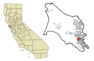
Strawberry is a census-designated place (CDP) and an unincorporated district of Marin County, California, United States. It shares a ZIP code (94941) with Mill Valley (hence, addresses in Strawberry are listed as "Mill Valley") and falls within its school districts; however, it is considered within the sphere of influence of the town of Tiburon. It is largely separated from Mill Valley by U.S. Route 101. Its population was 5,447 at the 2020 census.[4]
According to the United States Census Bureau, the Strawberry CDP has a total area of 1.9 square miles (4.9km2), of which 1.3 square miles (3.4km2) are land and 0.6 square miles (1.6km2), or 30.44%, are water.[2]Aramburu Island is separated from Strawberry by Richardson Bay.
Ring Mountain, holding significant evidence of Native American habitation, dominates the high ground east of Strawberry on the Tiburon Peninsula.[5]
Strawberry Spit was once the gathering site of harbor seals, who previously lived and fished here, but after development on the spit began in the 1980s they left.[citation needed]
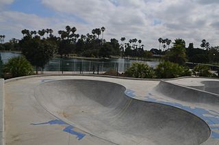
Strawberry is the site of a major transfer bus stop for Golden Gate Transit.
At the 2010 census 5,393 people, 2,510 households, and 1,307 families resided in the CDP. The population density was 4,094.9 inhabitants per square mile (1,581.0/km2). There were 2,729 housing units at an average density of 2,048.4 per square mile (790.9/km2). The racial makeup of the CDP was 80.2% White (76.1% non-Hispanic), 10.9% Asian, 2.1% African American, 0.3% Native American, 0.3% Pacific Islander, 1.8% from other races, and 4.3% from two or more races. 6.5% of the population was Hispanic or Latino of any race.[7]
The census reported that 95.4% of the population lived in households, 4.5% lived in non-institutionalized group quarters, and 0.1% were institutionalized.
Of the 2,510 households 25.5% had children under the age of 18 living in them, 41.0% were opposite-sex married couples living together, 8.0% had a female householder with no husband present, and 3.1% had a male householder with no wife present. 4.6% of households were unmarried opposite-sex partnerships and 0.8% were same-sex married couples or partnerships. 40.6% of households were one person and 14.3% were one person aged 65 or older. The average household size was 2.05 and the average family size was 2.80.
The age distribution was 19.9% under the age of 18, 4.2% aged 18 to 24, 27.7% aged 25 to 44, 30.8% aged 45 to 64, and 17.5% 65 or older. The median age was 44.0 years. For every 100 females, there were 90.8 males. For every 100 females age 18 and over, there were 86.5 males.
There were 2,729 housing units of which 39.2% were owner-occupied and 60.8% were occupied by renters. The homeowner vacancy rate was 1.4%; the rental vacancy rate was 2.4%. 44.2% of the population lived in owner-occupied housing units and 51.2% lived in rental housing units.
2000
At the 2000 census there were 5,302 people, 2,435 households, and 1,246 families in the CDP. The population density was 3,901.7 inhabitants per square mile (1,506.5/km2). There were 2,513 housing units at an average density of 1,849.3 per square mile (714.0/km2). The racial makeup of the CDP in 2010 was 76.1% non-Hispanic White, 2.1% non-Hispanic African American, 0.2% Native American, 10.9% Asian, 0.3% Pacific Islander, 0.3% from other races, and 3.5% from two or more races. Hispanic or Latino of any race were 6.5%.[8]
Of the 2,435 households 23.9% had children under the age of 18 living with them, 41.4% were married couples living together, 7.2% had a female householder with no husband present, and 48.8% were non-families. 38.8% of households were one person and 9.4% were one person aged 65 or older. The average household size was 2.08 and the average family size was 2.79.
The age distribution was 18.7% under the age of 18, 4.7% from 18 to 24, 35.2% from 25 to 44, 29.9% from 45 to 64, and 11.4% 65 or older. The median age was 40 years. For every 100 females, there were 93.8 males. For every 100 females age 18 and over, there were 90.0 males.
The median household income was $70,432 and the median family income was $99,409. Males had a median income of $70,298 versus $46,336 for females. The per capita income for the CDP was $50,581. About 4.0% of families and 7.1% of the population were below the poverty line, including 6.5% of those under age 18 and 2.9% of those age 65 or over.[9]
Strawberry Point School opened in 1952. Starting in 1969, 6th, 7th and 8th grade students attended Mill Valley Middle School. Strawberry Point School closed in 1990 and reopened in 2000.[12]Huey Lewis attended Strawberry Point School in the 1950s, where he skipped second grade.[13]
The site of the Golden Gate Baptist Theological Seminary on Strawberry Point, now known as the Seminary at Strawberry, was considered for the headquarters for the United Nations. This was because in the 1940s when the UN was established in San Francisco, Strawberry was undeveloped. It was seen as a tranquil and peaceful setting. New York City was eventually chosen.[14]
Government
Strawberry is unincorporated, receiving most of its general government services from Marin County. It is in the 3rd Supervisorial District and, as of 2018[update], is represented by Supervisor Kate Sears.[15]
The Strawberry Recreation District provides limited services in the area, including recreation facilities.[16] It has an elected board of five directors. District boundaries do not exactly match those of the CDP.
Strawberry is in the Southern Marin Fire Protection District, which also serves Tamalpais Valley, Homestead Valley, Almonte, Alto, part of the Town of Tiburon, and, since 2004, the City of Sausalito. Prior to the creation of the District in 1999, Strawberry was in the Alto-Richardson Fire Protection District.[17]
Strawberry shares a ZIP code (94941) with Mill Valley (hence, addresses in Strawberry are listed as "Mill Valley") and falls within its school districts. The city of Tiburon once considered Strawberry within its sphere of influence, but in 2004 the Marin Local Agency Formation Commission "concluded that gradual annexation of Strawberry would be unlikely."[18]
Marin County is located in the northwestern part of the San Francisco Bay Area of the U.S. state of California. As of the 2020 census, the population was 262,231. Its county seat and largest city is San Rafael. Marin County is across the Golden Gate Bridge from San Francisco, and is included in the San Francisco–Oakland–Berkeley, CA Metropolitan Statistical Area.
Moores Mill is an unincorporated community and census-designated place (CDP) in Madison County, Alabama, United States, and is included in the Huntsville-Decatur Combined Statistical Area. The population was 6,729 at the 2020 census, up from 5,682 at the 2010 census.
Strawberry is an unincorporated community and census-designated place (CDP) in Gila County, Arizona, United States. The population was 961 at the 2010 census.
Alondra Park, also known as El Camino Village, is a census designated place (CDP) in the South Bay region of Los Angeles County, California, United States. It is the unincorporated area north of Alondra Community Regional Park and El Camino College. It is east of Lawndale, south of Hawthorne, west of Gardena, and north of Torrance. Manhattan Beach Boulevard and Crenshaw Boulevard are the two major cross streets in the area. The population was 8,569 at the 2020 census, down from 8,592 at the 2010 census. There is an official Alondra Park Post Office of the U.S. Postal Service in nearby Gardena, California. Urbanized cement-lined Dominguez Creek bisects a portion of Alondra Park.
Belvedere is a residential incorporated city located on the San Francisco Bay in Marin County, California, United States. Consisting of two islands and a lagoon, it is connected to the Tiburon Peninsula by two causeways. At the 2020 census, the population was 2,126. The per-capita income of Belvedere residents in the year 2000 was $250,000, but currently the average income is $283,000, making it one of the highest-income cities in California and the eighth highest-income community in the United States. Belvedere and Tiburon share a post office and the 94920 ZIP code.
Kentfield is a census-designated place (CDP) in Marin County, California, United States, just north of San Francisco. Kentfield is located 2 miles (3 km) southwest of downtown San Rafael, at an elevation of 115 feet. The population was 6,808 at the 2020 census. The ZIP codes are 94904 for street addresses, and 94914 for PO boxes, and are shared with the neighboring community of Greenbrae.
Lagunitas-Forest Knolls is a census-designated place, composed of two unincorporated areas in the western half of the San Geronimo Valley in Marin County, California. It is located to the west of San Geronimo and Woodacre. The population was 1,924 at the 2020 census.
Lucas Valley-Marinwood is a census-designated place (CDP) in Marin County, California, United States. It includes the neighborhoods of Lucas Valley and Marinwood. As of the 2020 census, the population was 6,259.
Mill Valley is a city in Marin County, California, United States, located about 14 miles (23 km) north of San Francisco via the Golden Gate Bridge and 52 miles (84 km) from Napa Valley. The population was 14,231 at the 2020 census.
Muir Beach is a census designated place (CDP), unincorporated community, and beach on the Pacific Ocean. The community is located 16.5 miles (26.6 km) northwest of San Francisco in western Marin County, California, United States. Unlike many other entities in the area, it is not named directly in honor of conservationist John Muir; instead, it was named after Muir Woods National Monument to capitalize on the latter's popularity. The population was 304 at the 2020 census. The community itself flanks the northwest side of the beach.
San Geronimo is a census-designated place (CDP) located in the San Geronimo Valley in Marin County, California in the United States. San Geronimo is bordered by Lagunitas-Forest Knolls to its west and Woodacre to its east. It is 8 miles (13 km) southwest of downtown Novato at an elevation of 292 feet (89 m). The population was 510 at the 2020 census.
Stinson Beach is an unincorporated community and census-designated place (CDP) in Marin County, California, on the west coast of the United States. Stinson Beach is located 2.5 miles (4 km) east-southeast of Bolinas, at an elevation of 26 feet (8 m). The population of the Stinson Beach CDP was 541 at the 2020 census.
Tamalpais-Homestead Valley is a census-designated place (CDP) in Marin County, California, United States. The population was 11,492 at the 2020 census.
Tiburon is an incorporated town in Marin County, California. It is located on the Tiburon Peninsula, which reaches south into the San Francisco Bay. It shares a ZIP code (94920) with the smaller incorporated city of Belvedere, which occupies the southwest part of the peninsula and is contiguous with Tiburon. Tiburon is bordered by Corte Madera to the north and Mill Valley to the west, but is otherwise mostly surrounded by the bay. Besides Belvedere and Tiburon, much of the peninsula is unincorporated, including portions of the north side and the communities of Strawberry and Paradise Cay.
Woodacre is an unincorporated town and census-designated place (CDP) in Marin County, California, United States. The population was 1,410 at the 2020 census.
West Springfield is a census-designated place (CDP) in Fairfax County, Virginia, United States. The population was 23,369 at the 2020 census.
Nicasio is an unincorporated community and census-designated place in Marin County, California, United States. It is located 8 miles (13 km) west-southwest of Novato, at an elevation of 194 feet (59 m). As of the 2020 census the CDP population was 81, while population estimates for the surrounding area range from about 600 to about 900 people.
Marin City is an unincorporated community and census-designated place (CDP) in Marin County, California, United States. As of the 2020 census, it had a population of 2,993, up from 2,666 in 2010. It is located 1.5 miles northwest of downtown Sausalito, 8 miles (13 km) south-southeast of San Rafael, and about 5 miles (8 km) north of San Francisco from the Golden Gate Bridge, at an elevation of 23 feet (7.0 m). Marin City was developed for housing starting in 1942, to accommodate wartime shipyard workers and other migrants to California. Among those were African Americans from the South in the Great Migration, which continued until 1970.
Sleepy Hollow is a census-designated place in Marin County, California, United States. It is located 7 miles (11 km) south of downtown Novato at an elevation of 177 feet (54 m). Its population as of the 2020 census was 2,401.
Alto is a census-designated place adjacent to Mill Valley in Marin County, California. It lies at an elevation of 26 feet. The population was 732 at the 2020 census.
This page is based on this Wikipedia article Text is available under the CC BY-SA 4.0 license; additional terms may apply. Images, videos and audio are available under their respective licenses.