Terraced Gardens, Rivington

Last updated

Terraced Gardens, Rivington
7 Arch Bridge, Rivington - 8136491268.jpg
Seven Arch Bridge, Rivington
Lancashire UK location map.svg
Red pog.svg
Location in Lancashire
Location Chorley
Coordinates 53°37′11″N2°32′53″W / 53.6197°N 2.5480°W / 53.6197; -2.5480
Created1900
Operated by Rivington Heritage Trust on behalf of UU
DesignationGrade II
The Pigeon Tower, Rivington Pigeon Tower in Rivington - geograph.org.uk - 501205.jpg
The Pigeon Tower, Rivington

Terraced Gardens of Rivington (Leverhulmes Former Gardens) is a landscaped woodland on the hillside of Rivington Pike, in Rivington Parish in the Chorley Borough of Lancashire, England, originally designed as a Garden by T.H. Mawson and built as curtilage to a home of the soap magnate Viscount Leverhulme; as such, the area is not part of Lever Park. The gardens contains and abuts the SSSI of the West Pennine Moors. Today the former gardens are Grade II listed and contain eleven Grade II structures. The original design had three elements — the upper part being in the romanesque architectural style, the lower section, known as the Ravine, was a woodland with a man-made stream, and a Japanese-style garden, with a man-made pond constructed of Pulmonite which remains today. The gardens are leased to Rivington Heritage Trust by United Utilities and are undergoing restoration and preservation.

Contents

Rivington Gardens design Rivington Gardens design.jpg
Rivington Gardens design
Japanese Lake 1925 View of Japanese Lake at Leverhulmes Rivington Bungalow Grounds c 1925.png
Japanese Lake 1925

The Bungalow

The original gardens were created to serve a home called the Bungalow (demolished in 1948) belonging to Leverhulme, a founder of Lever Brothers, today known as Unilever. The site has surviving stone structures that formed part of the Italian-style gardens designed by Thomas Mawson between 1905 and 1922. Inspired by Villa d’Este near Rome,[ citation needed ] its design features in his book 'The Art and Craft of Garden Making, published in 1912. [1] [2] There were four lodge houses acting as gatehouses of the grounds. Three were small prefabricated cottage-style properties, the fourth was Stone House Lodge, which had a design with an archway incorporated and build over the entrance.

Roynton Cottage was built on the hillside and was a large prefabricated wooden structure, purchased from the Portable Building Company, Manchester, earth was first broken for it in 1900, [3] this wooden structure was destroyed 1913 in an arson attack by suffragette Edith Rigby The home and grounds were referred to in the Liverpool Corporation Act 1902 as 'The Bungalow', owned by William Hesketh Lever, was protected from being taken by the water company without an agreement, the act also protected Leverhulmes shooting rights. [4] This first building became two stories in 1912 just prior to the fire that destroyed it. [2] Its replacement, designed by his old friend Jonathan Simpson, was built of stone in 1914 at first as a single-story structure with Pergolas, a courtyard, and an aviary. The courtyard was developed into a ballroom and a second floor was added over the servant's quarters as a housekeepers' room in 1923. The building sat on an elevation higher than what became known as the Orchestral lawn, featuring its sundial and a lower elevation than the Pigeon Tower. The current Sun Dial is a reproduction of the missing original donated by the local quarry operator in 2019. [5]

The main building was accessed by a driveway from Belmont Road. Below the level of the Bungalow is a large stone retaining wall, a section with steps that has arrowslits. Below this level is the Italian-style lake, a small former boating lake that is a feature of this section of the former garden. During the Leverhulme era, the Bungalow and Rivington Hall were home to a highly valuable collection of antiques, from paintings, furniture, statues, pottery, and tapestries. Leverhulmes collection and all household and garden items, even the pigeons, were sold by auction through Knight Frank & Rutley after his death in 1925. [6]

The artist Alfred East stayed at Roynton Cottage in the summer of 1909. Lever commissioned a series of paintings of the surrounding landscape, the reservoirs, the country park, the village, and the pike. [7] Lever gave 15 of them to Bolton Art Gallery [8] and others to Bolton School, the Walker Art Gallery in Liverpool and the Lady Lever Art Gallery [9] at Port Sunlight. East gave two watercolors, A glimpse of Rivington Water and In Rivington Park to Kettering Museum and Art Gallery. The gallery acquired an oil painting [From] Rivington Pike that East exhibited at the Royal Academy in 1913 in the 1960s. [7]

The area is now woodland with remains including foundations of the bungalow, a number of stone summer houses, footpaths, steps, bridges, three ponds, streams, and the restored Pigeon Tower. A Japanese style garden was added in 1923, its features have since been lost, but the pond remains.

Pigeon Tower (Dovecote)

The well-known landmark, reroofed in 2005 and again restored in 2018, is known by various names including Lookout Tower, Dovecote Tower and the Pigeon Tower. It was built between 1905 and 1909 and was a feature created by Mawson as part of an overall design, erected as a birthday present for Leverhulme's wife. Above the ornate fireplace on the upper floor is an inscription of their initials, spelling WHEEL, William Hesketh Elizabeth Ellen Lever and Leverhulme's motto, ‘MUTARE VEL TIMERE SPERNO’ ‘I spurn the fear to change’. The building features a spiral stone staircase and four floors. [10]

Ravine

Further down the hillside, a section was built in 1921 as a man-made ravine, which along with the Japanese Garden built 1922 made use of artificial rock known as Pulhamite. [11] [12]

Ravine, Terraced Gardens Rivington Terraced Gardens - geograph.org.uk - 1769330.jpg
Ravine, Terraced Gardens

Magee Era

After Lever's death, The Bungalow and grounds were purchased by the Bolton brewer, John Magee during which time he opened the gardens on open days for charity fundraising. Magee was a resident there from 1925 until his death in 1939, during which time he converted part of the great lawn into a tennis court for his daughters. After his death his executor offered the property to Bolton Council who turned it down, fearing the effect of increased local rates needed to cover maintenance costs. Liverpool Corporation then purchased the property in late 1939 in turbulent times just prior to the Second World War. During the war, the building and grounds were requisitioned by the military, and a significant decoy site was nearby. The bungalow was damaged while in military use and had significant neglect during the war.

In 1945 there was hope use could be found of the Bungalow with use by charities, however, the corporation objected and insisted it must be used as a private dwelling, this prevented charities, and voluntary groups from coming forward, with no buyers and with a great level of neglect and repairs needed demolition was announced 1947 and went ahead by 1948. The Liverpool Corporation Act required that the land owners consent always be obtained for commercial use, since the water company took ownership they have operated without restriction. Protective covenants in the sale from Leverhulme are not enforced.

Great Lawn

A substantial change during the Magee era was the conversion of a large area known as 'The Great Lawn' to private tennis courts, this site has been granted planning consent in 2021 by Chorley Council for the Heritage Trust to hold weddings and wedding receptions, with marquee, catering trailers and temporary toilets. Part of the site is designated as a Site of Special Scientific Interest [13] Ecological Mitigation Measures were discharged in 2018. [14] In 2022 the public toilets serving the Terraced Gardens and wider area were ripped out and converted to a Cafe / Takeaway without replacements.

Preservation

Liverpool City Council, the former owner, neglected the gardens and planned to demolish the structures and clear the site in 1967, after a public outcry, the Chorley local authority moved to protect the garden's structures by ensuring listed status thus saving the Terraced Gardens from bulldozers.

By 1974 the park and gardens had passed to the North West Water Authority from Liverpool Corporation, and to United Utilities on privatisation. In the mid-1970s the landowner planned to demolish the remaining garden structures, this was prevented by intervention with listed building status by Chorley Council. From 1976 a local voluntary group, the Bolton Conservation Volunteers stepped in and cleared overgrowth and worked to maintain what had by then become an important public asset. [15] The site was used for unofficial Music festivals in 1976 and 1977.

Blue Planet Scheme

Rivington Heritage Trust, a body set up in 1997 by United Utilities in order to obtain £15 million in funding for 'Blue Planet Park' had its plans rejected for funding by the Millennium Commission which would have seen them take over all of Lever Park and Rivington Pike, plans were opposed by six regional MPs and were met with huge local opposition. A concern was that the area would be used as a venue for music festivals and other events and fees would be charged, Sue Wright, Media Relations Manager for North West Water made a public statement saying they would never do so. [16] [17] The Bill and plan was rejected. Despite this the trust now hold regular music festivals and other events. The Terraced Gardens are available for hire. [18]

Blue Planet associated planning applications were Restoration of semi-derelict landscaped gardens including rebuilding of Stone House Lodge, Tea Houses, Visitors' Pavilion & Bothy, Ref. No: 96/00848/FUL, Application for Listed Building Consent for restoration of various structures, Ref. No: 96/00849/LBC, Infrastructure including car parks, access roadways, paths and avenues, park & ride system, interpretation & screening, Ref. No: 96/00851/FUL all applications were withdrawn. [19] The water company withdrew its bill in parliament in 1997, known as the Lever Park Act. Plans were put on hold by 1998. [20]

All Rhododendron were removed from the gardens in 2006 after Ramorum Disease was found at the site. [21] The site is now a managed woodland.

Rivington Heritage Trust

Although Rivington Heritage Trust abandoned much of the original Blue Planet Scheme and formed a plan to proceed gradually whilst lobbying and obtaining public support, by 2013 they had succeeded in obtaining £60,000 in grant funding from the Heritage Lottery Fund the Big Lottery Fund and presented new plans for the Rivington Terraced Gardens. [22] [23] By 2016 the trust and Groundwork Cheshire Lancashire and Merseyside were successful in obtaining a grant of £3.4 million from the Heritage Lottery Fund to conserve and repair the Rivington Terraced Gardens and remaining Grade II listed structures. A lease of 50 years was also agreed in 2016 by United Utilities to the Rivington Heritage Trust. [24] The Clearance work has been undertaken by unpaid volunteers. [25] The trust comprises a number of local councillors and employees of United Utilities.

The former gardens are now used to hold a variety of events, mainly at the Great Lawn, former Tennis Lawns, and Italian Lake and Orchestral lawn. There are now private events held here and it is available for hire for weddings. [25] [26] The Lancashire Environmental Fund awarded a grant of £23,000 in 2022 to improve accessibility from Lower House car park via Roynton Road to improve access at the site. [27]

Public Access

Although the Terraced Gardens are not part of Lever Park a large area has right to roam and there is a public footpath, although officially never closed the trust charges admission during events and part is used for private hire, at which time public access is blocked. The lower section of the grounds, the ravine is usually freely accessible for members of the public.

After the demolition in 1948 for half a century, the public could roam the whole site at will. Rivington former Japanese and Kitchen Gardens within the Bungalow Grounds are now part of an extensive area of open access land recorded at Lancashire County Council and has a right to roam protected by the statutory powers in the Countryside and Rights of Way Act 2000. [28] [29] There is a public footpath and a bridleway from Lever Park to Rivington Pike and Terraced Gardens. The public footpath number 82 runs through the gardens from the Ravine via the former Japanese and Kitchen Gardens, which is also an area of open access land with a right to roam, passing upward past the Great Lawn and an area of Bilberries [1] part of the West Pennine Moors SSSI, [30] toward the site of the former Bungalow and landmark Pigeon Tower then heading to Rivington Pike via Belmont Road.

Rivington Pike has access via Belmont Road (USRN 7400767) and is an open public road from Horwich, the road becomes rougher and less maintained the further up the hill it climbs in the direction of the Pigeon Tower, where it splits. The descending road there leads to Lower House car park but the surface of the road is washed away. Roynton Road (USRN: 7400820) provides access to the hillside and the Terraced Gardens from Lever Park and Sheep House Lane, from the direction of Chorley, Belmont and Horwich, the route has locked gates. [31] [32] [29]

At Rivington Terraced Gardens Wheelchair access is possible for all-terrain wheelchairs to attend events via the entrance from Lower House Car Park to the great lawn by arrangement.

Listed buildings and structures

Key

GradeCriteria
IIBuildings of national importance and special interest.
Name and locationPhotographGradeDateNotes
Loggia c. 70 metres west of Pigeon tower in Lord Leverhulme's Terraced Gardens
53°37′27″N2°32′50″W / 53.6242°N 2.5473°W / 53.6242; -2.5473 (Loggia in Terraced Gardens)
Loggia, Rivington.jpg
II1906The remains of a loggia with arches overlooking a former boating lake in the Terraced Gardens, a former private gardens designed by Thomas Mawson for William Lever. [33]
Two archways in Lord Leverhulme's Terraced Gardens
53°37′24″N2°32′50″W / 53.6233°N 2.5471°W / 53.6233; -2.5471 (Two Archways in Lord Leverhulme's Terraced Gardens)
Archways, Rivington.jpg
II1906These archways are an intact element of the remains of private gardens designed by Thomas Mawson for Leverhulme's Rivington Bungalow. [34]
Pigeon Tower north east corner of Lord Leverhulme's Terraced Garden
53°37′27″N2°32′47″W / 53.6243°N 2.5463°W / 53.6243; -2.5463 (Pigeon Tower)
Pigeon Tower - geograph.org.uk - 303693.jpg
II1905 and 1909The Pigeon Tower was built in gritstone with four storeys, each a single room., on the boundary of the Terraced Gardens. It has a steeply pitched roof and a corbelled chimney. On the west side is a semi-circular stair turret with a conical roof. The fourth storey, a sitting room, has four light mullioned windows on two sides. The second and third storeys are a dovecote. On the west wall are square pigeon holes with perching ledges. [35]
Seven Arch Bridge in Lord Leverhulme's Terraced Gardens
53°37′25″N2°32′55″W / 53.6235°N 2.5485°W / 53.6235; -2.5485 (Seven Arch Bridge in Lord Leverhulme's Terraced Gardens)
7 Arch Bridge - geograph.org.uk - 96653.jpg
II1910The bridge, crossing over Royton Road within the Terraced Gardens has random sandstone rubble walls and round stone slate arches and parapets. The large round archway is crossed by six small arches. It carries a footpath over an old roadway. In memoirs recalling after dinner stories the second viscount Leverhulme thought the bridge design was influenced by one in Nigeria, however no similar bridge exists there and is more likely the design is based on the Pont du Gard, France. [36]

Related Research Articles

<span class="mw-page-title-main">Bolton</span> Town in Greater Manchester, England

Bolton is a town in Greater Manchester in England. In the foothills of the West Pennine Moors, Bolton is between Manchester, Blackburn, Wigan, Bury and Salford. It is surrounded by several towns and villages that form the wider borough, of which Bolton is the administrative centre. The town is also within the historic county boundaries of Lancashire.

<span class="mw-page-title-main">Horwich</span> Human settlement in England

Horwich is a town and civil parish in the Metropolitan Borough of Bolton, Greater Manchester, England, within the historic county boundaries of Lancashire. It is 5.3 miles (8.5 km) southeast of Chorley, 5.8 miles (9.3 km) northwest of Bolton and 15 miles (24 km) northwest of Manchester. It lies at the southern edge of the West Pennine Moors with the M61 motorway passing close to the south and west. At the 2011 Census, Horwich had a population of 20,067.

<span class="mw-page-title-main">William Lever, 1st Viscount Leverhulme</span> English Industrialist, Politician and Imperialist

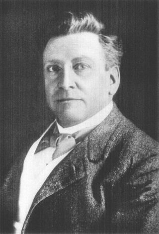
William Hesketh Lever, 1st Viscount Leverhulme, was an English industrialist, philanthropist, and politician. Having been educated at a small private school until the age of nine, then at church schools until he was fifteen; a somewhat privileged education for that time, he started work at his father's wholesale grocery business in Bolton. Following an apprenticeship and a series of appointments in the family business, which he successfully expanded, he began manufacturing Sunlight Soap, building a substantial business empire with many well-known brands such as Lux and Lifebuoy. In 1886, together with his brother, James, he established Lever Brothers, which was one of the first companies to manufacture soap from vegetable oils, and which is now part of the British multinational Unilever. In politics, Lever briefly sat as a Liberal MP for Wirral and later, as Lord Leverhulme, in the House of Lords as a Peer. He was an advocate for expansion of the British Empire, particularly in Africa and Asia, which supplied palm oil, a key ingredient in Lever's product line. His firm had become associated with activities in the Belgian Congo by 1911.

<span class="mw-page-title-main">Winter Hill (North West England)</span>

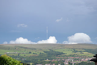
Winter Hill is a hill on which the three boroughs of Chorley, Blackburn with Darwen and Bolton meet in North West England. It is located on Rivington Moor, Chorley and is 1,496 feet (456 m) high. Part of the West Pennine Moors, it is a popular walking area, and has been the site of mining activity, aeroplane disasters and murders.

<span class="mw-page-title-main">Anglezarke</span> Human settlement in England

Anglezarke is a sparsely populated civil parish in the Borough of Chorley in Lancashire, England. It is an agricultural area used for sheep farming and is also the site of reservoirs that were built to supply water to Liverpool. The area has a large expanse of moorland with many public footpaths and bridleways. The area is popular with walkers and tourists; it lies in the West Pennine Moors in Lancashire, sandwiched between the moors of Withnell and Rivington, and is close to the towns of Chorley, Horwich and Darwen. At the 2001 census it had a population of 23, but at the 2011 census the population was included within Heapey civil parish. The area was subjected to depopulation after the reservoirs were built.

<span class="mw-page-title-main">Rivington Pike</span> Hill in Lancashire, England

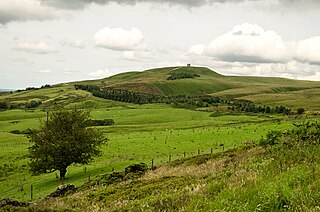
Rivington Pike is a hill on Winter Hill, part of the West Pennine Moors at Rivington, Chorley in Lancashire, England. The nearest towns are Adlington and Horwich. The land and building are owned and managed by Chorley Council. The Pike Tower is a prominent local landmark and is located at the summit, it is part of Lever Park. The area is popular with hill walkers and for mountain biking.

<span class="mw-page-title-main">Anderton, Lancashire</span> Human settlement in England

Anderton is a civil parish in the Borough of Chorley in Lancashire, England. It is now a suburb of Adlington, 5 miles (8 km) northwest of Bolton. Within its boundaries are the Rivington Reservoirs. Grimeford village is in the parish. In 2001, the parish had a population of 1,206, increasing to 1,316 at the 2011 census.

<span class="mw-page-title-main">Rivington</span> Village in Lancashire, England

Rivington is a village and civil parish of the Borough of Chorley, Lancashire, England, occupying 2,538 acres. It is about 6 miles (9.7 km) southeast of Chorley and about 8+12 miles (13.7 km) northwest of Bolton. Rivington is a rural area consisting primarily of agricultural grazing land, moorland, with hill summits including Rivington Pike and Winter Hill within the West Pennine Moors. The area has a thriving tourist industry centred around reservoirs created to serve Liverpool in the Victorian era and Lever Park created as a public park by William Lever at the turn of the 20th century, with two converted barns, a replica of Liverpool Castle and open countryside. Rivington and Blackrod High School is located here. Rivington and its village had a population of 109 at the 2011 Census.

<span class="mw-page-title-main">West Pennine Moors</span>

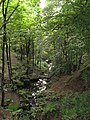
The West Pennine Moors is an area of the Pennines covering approximately 90 square miles (230 km2) of moorland and reservoirs in Lancashire and Greater Manchester, England. It is a Site of Special Scientific Interest.

<span class="mw-page-title-main">Thomas Hayton Mawson</span>

Thomas Hayton Mawson, known as T. H. Mawson, was a British garden designer, landscape architect, and town planner.

<span class="mw-page-title-main">Bolton School</span> Independent day school in Greater Manchester, England

Bolton School is a private day school in Bolton, Greater Manchester. It comprises a co-educational nursery, co-educational infant school, single sex junior schools and single sex senior schools including sixth forms. With over 2,500 pupils, it is one of the largest independent day schools in the country.

<span class="mw-page-title-main">Rivington and Blackrod High School</span> Voluntary controlled comprehensive and sixth form school in England

Rivington and Blackrod High School in the North West region of England is a Leverhulme Trust multi-academy comprehensive school. Alongside Harper Green School, it operates as a Church of England teaching environment with a sixth form school. The school is located at two sites, with the upper school situated on Rivington Lane in Rivington, Lancashire, and the lower school situated on Albert Street in Horwich, Greater Manchester.

<span class="mw-page-title-main">Pulhamite</span> Material simulating natural stone

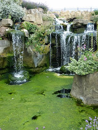
Pulhamite was a patented anthropic rock material invented by James Pulham (1820–1898) of the firm James Pulham and Son of Broxbourne in Hertfordshire. It was widely used for rock gardens and grottos.

<span class="mw-page-title-main">Tirley Garth</span> Historic site in Cheshire, England

Tirley Garth is a large country house some 2.5 miles (4 km) to the north of Tarporley, Cheshire, England. The house together with its entrance courtyard walls are recorded in the National Heritage List for England as a designated Grade II* listed building.

<span class="mw-page-title-main">Rivington Hall</span> Manor house in Lancashire, England

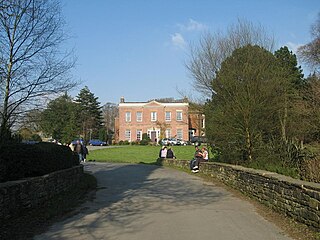
Rivington Hall is a Grade II* listed building in Rivington, Lancashire, England. It was the manor house for the Lords of the Manor of Rivington. The hall is of various builds as successor to a 15th-century timber-framed courtyard house that was built near to the present building of which no trace remains. It is a private residence.

<span class="mw-page-title-main">Rivington Hall Barn</span> Barn in Lancashire, England

Rivington Hall Barn adjoins Rivington Hall in Rivington, Lancashire, near Chorley and Bolton. The Tithe barn foundation stones support a Medieval cruck construction and possibly date to the between the 9th and 15th centuries. The structure was restored, altered and enlarged in 1905 by Jonathan Simpson for Lord Leverhulme. It is a Grade II Listed building.

<span class="mw-page-title-main">Listed buildings in Rivington</span>

Rivington in the Borough of Chorley, Lancashire, is situated on the edge of the West Pennine Moors, at the foot of Rivington Pike overlooking reservoirs created for Liverpool Corporation Waterworks in the 19th century. There are twenty eight listed buildings within Rivington, two are classified by English Heritage as Grade II*, the rest as Grade II; Rivington has no Grade I Listed buildings.

<span class="mw-page-title-main">Inverforth House</span> Historic site in Hampstead, London

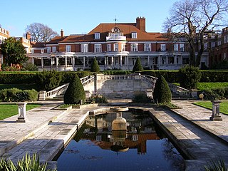
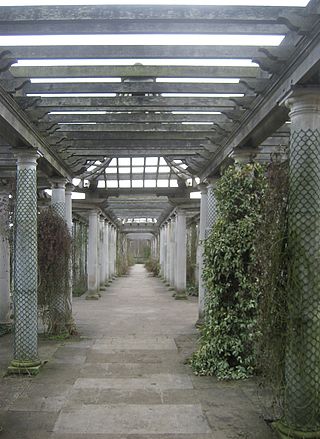
Inverforth House is a large detached house on North End Way at North End on the outskirts of Hampstead in the London Borough of Camden, NW3. Owned by William Lever, 1st Viscount Leverhulme from 1904 to 1925, The Hill was bought by Andrew Weir, 1st Baron Inverforth after Leverhulme's death in 1925, and following was given to Manor House Hospital after Inverforth's death in 1956. Inverforth House was home to the Orthopaedic Society Hospital from the 1950s to the 1980s, and was converted into two houses and seven apartments in the late 1990s.

Rivington Heritage Trust, an arm of United Utilities was formed 1997, is a vehicle created to obtain charitable funding for United Utilities to enable the PLC to reduce costs of its statutory obligations to upkeep and maintain its Rivington property. Previously known as the United Utilities Heritage Foundation, it aims to preserve the Terraced Gardens at Rivington, Lancashire, England and is incorporated with charitable aims to "To consult with stakeholders on the use and development of Rivington Terraced Gardens for the benefit of the public and the environment." The objects are to conserve, preserve, maintain, protect and enhance for the benefit of the public land and structures of outstanding natural beauty or of historic or architecture", its headquarters have remained the United Utilities Head Office at Warrington, the freeholder of land it manages.

References

Notes

  1. 1 2 Mawson 1912, p. 374.
  2. 1 2 Smith 1984, p. 40.
  3. Smith 1984, p. 34.
  4. Preston's Blue Plaques, Edith Rigby. Preston Council. Archived from the original (pdf) on 28 September 2011. Retrieved 21 June 2010.
  5. "Rivington Terrace Gardens". Armstrongs Group. Armstrongs Group. Retrieved 18 November 2022.
  6. Auctioneers, Knight Frank & Rutley (1925). The Bungalow and Rivington Hall, Horwich, Lancashire. The Metropolitan Museum of Art. Retrieved 24 October 2022.
  7. 1 2 Sir Alfred East (1844- 1913). Friends of Kettering Museum and Art Gallery. Retrieved 31 March 2017.
  8. View from the Bungalow, Rivington. ArtUK. Retrieved 31 March 2017.
  9. Rivington Water. ArtUK. Retrieved 31 March 2017.
  10. "The PIGEON TOWER". RHT. Rivington Heritage Trust. Retrieved 24 October 2022.
  11. Smith 1984, p. 22.
  12. Waymark 2009, pp. 77–81.
  13. "Planning app. 21/00683/LBC and 21/00682/FUL". Chorley. Retrieved 2 January 2023.
  14. "18/00236/DIS". Chorley Planning. Chorley Council. Retrieved 2 January 2023.
  15. "What is BCV?". BCV. Bolton Conservation Volunteers. Retrieved 7 October 2019.
  16. "Meeting demanded on park's future". Bolton News. Associated Press. 31 July 1997. Retrieved 24 June 2019.
  17. Wright, Sue (7 February 1997). "Bill will protect park". Bolton News. Bolton News. Retrieved 6 July 2019.
  18. "Rivington Music Festival". Visit Lancashire. Marketing Lancashire. Retrieved 25 May 2023.
  19. "Planning Application Rivington Terraced Gardens". Chorley. Chorley Gov. Retrieved 4 November 2022.
  20. "The park's safe in our hands, says Trust". Bolton News. Bolton News. 8 April 1997. Retrieved 6 July 2019.
  21. "Follow The path". No. 2 December 2005. Lancashire Telegraph. Retrieved 7 October 2019.
  22. Thorpe, Liam (13 July 2013). "Rivington Terraced Gardens get £6,000 lottery cash boost". Associated Press. Bolton News. Retrieved 7 October 2019.
  23. "'Blue Planet' park plan hopes are scotched". Bolton News. Associated Press. 24 September 1998. Retrieved 24 June 2019.
  24. "Land Registry Title Number LAN62310". Gov UK. Gov UK. Retrieved 24 June 2019.
  25. 1 2 "Events". RHT. Rivington Heritage Trust. Retrieved 3 August 2019.
  26. Holbrook, Karl (1 September 2019). "Downpours can't dampen spirits at Rivington Music Festival". Bolton News. Associated Press. Retrieved 6 October 2019.
  27. Finney, Lewis (20 January 2022). "Rivington Terraced Gardens receive £23,000 grant to improve accessibility". Bolton News. NewsQuest. Retrieved 21 January 2022.
  28. "Public Access Land to the North of Bolton". Bolton Council. Bolton Council Highways Dept. Retrieved 19 June 2019.
  29. 1 2 "Definitive map". Lancashire GOV UK. Lancashire County Council. Retrieved 27 June 2019.
  30. "MAGIC Defra Mapping". DEFRA. GOV.UK. Retrieved 15 August 2019.
  31. "National Street Gazetteer". Find My Street. findmystreet.co.uk. Retrieved 9 September 2019.
  32. "Types of paths in England and Wales". Ramblers Association. Ramblers Association. Retrieved 4 August 2019.
  33. Historic England, "Loggia circa 70 metres west of Pigeon Tower in Lord Leverhulme's Terraced Gardens at SD 639 143 (1317582)", National Heritage List for England, retrieved 25 June 2011
  34. Historic England, "Two archways and associated retaining walls to two stone staircases at north corner of tennis lawn in Leverhulme's Terraced Gardens at SD 639 142 (1362123)", National Heritage List for England, retrieved 25 June 2011
  35. Historic England, "Pigeon Tower at north east corner of Lord Leverhulme's Terraced Gardens at SD 639 143 (1317613)", National Heritage List for England, retrieved 25 June 2011
  36. Historic England, "Lever Bridge in Lord Leverhulme's Terraced Gardens at SD 638 142 (1072506)", National Heritage List for England, retrieved 25 June 2011

Bibliography

Further reading