
British Columbia is the westernmost province of Canada. Situated between the Pacific Ocean and the Rocky Mountains, the province has a diverse geography, with rugged landscapes that include rocky coastlines, sandy beaches, forests, lakes, mountains, inland deserts and grassy plains. British Columbia borders the province of Alberta to the east; the territories of Yukon and Northwest Territories to the north; the U.S. states of Washington, Idaho and Montana to the south, and Alaska to the northwest. With an estimated population of over 5.6 million as of 2024, it is Canada's third-most populous province. The capital of British Columbia is Victoria, while the province's largest city is Vancouver. Vancouver and its suburbs together make up the third-largest metropolitan area in Canada, with the 2021 census recording 2.6 million people in Metro Vancouver.

Saint John is a seaport city located on the Bay of Fundy in the province of New Brunswick, Canada. It is Canada's oldest incorporated city, established by royal charter on May 18, 1785, during the reign of George III. The port is Canada's third-largest by tonnage with a cargo base that includes dry and liquid bulk, break bulk, containers, and cruise. The city was the most populous in New Brunswick until the 2016 census, when it was overtaken by Moncton. It is currently the second-largest city in the province, with a population of 69,895 over an area of 315.59 km2 (121.85 sq mi).

Richmond is a city in the coastal Lower Mainland region of British Columbia, Canada. It occupies almost the entirety of Lulu Island, between the two estuarine distributaries of the Fraser River. Encompassing the adjacent Sea Island and several other smaller islands and uninhabited islets to its north and south, it neighbours Vancouver and Burnaby on the Burrard Peninsula to the north, New Westminster and Annacis Island to the east, Delta to the south, and the Strait of Georgia to the west.

Hagley Park is the largest urban open space in Christchurch, New Zealand, and was created in 1855 by the Provincial Government. According to the government's decree at that time, Hagley Park is "reserved forever as a public park, and shall be open for the recreation and enjoyment of the public." Hagley Park is characterised by its trees and broad open spaces. Hagley Park was named after Hagley Park, the country estate of Lord Lyttelton, who became chairman of the Canterbury Association in March 1850.

Burnaby is a city in the Lower Mainland region of British Columbia, Canada. Located in the centre of the Burrard Peninsula, it neighbours the City of Vancouver to the west, the District of North Vancouver across the confluence of the Burrard Inlet with its Indian Arm to the north, Port Moody and Coquitlam to the east, New Westminster and Surrey across the Fraser River to the southeast, and Richmond on the Lulu Island to the southwest.

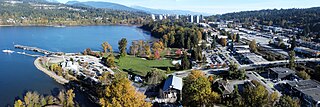
New Westminster is a city in the Lower Mainland region of British Columbia, Canada, and a member municipality of the Metro Vancouver Regional District. It was founded by Major-General Richard Moody as the capital of the Colony of British Columbia in 1858 and continued in that role until the Mainland and Island colonies were merged in 1866. It was the British Columbia Mainland's largest city from that year until it was passed in population by Vancouver during the first decade of the 20th century.

Coquitlam is a city in the Lower Mainland of British Columbia, Canada. Mainly suburban, Coquitlam is the sixth-largest city in the province, with a population of 148,625 in 2021, and one of the 21 municipalities comprising Metro Vancouver. The mayor is Richard Stewart.

Organic lawn management or organic turf management or organic land care or organic landscaping is the practice of establishing and caring for an athletic turf field or garden lawn and landscape using organic horticulture, without the use of manufactured inputs such as synthetic pesticides or artificial fertilizers. It is a component of organic land care and organic sustainable landscaping which adapt the principles and methods of sustainable gardening and organic farming to the care of lawns and gardens.

The history of British Columbia covers the period from the arrival of Paleo-Indians thousands of years ago to the present day. Prior to European colonization, the lands encompassing present-day British Columbia were inhabited for millennia by a number of First Nations.
Port Moody is a city in British Columbia, Canada, and a member municipality of the Metro Vancouver Regional District. It envelops the east end of Burrard Inlet and is the smallest of the Tri-Cities, bordered by Coquitlam on the east and south and by Burnaby on the west. The villages of Belcarra and Anmore, along with the rugged Coast Mountains, lie to the northwest and north, respectively. It is named for Richard Clement Moody, the first lieutenant governor of the Colony of British Columbia.

Flagstaff Gardens is the oldest park in Melbourne, Victoria, Australia, first established in 1862. Today it is one of the most visited and widely used parks in the city by residents, nearby office workers and tourists. The gardens are notable for their archaeological, horticultural, historical and social significance to the history of Melbourne.

Queen's Park is an area located partly in the City of Westminster and mostly in the London Borough of Brent. Some of the area within Westminster forms a civil parish, the first to be created in London since the right of communities to establish civil parishes was enacted in 2007. The area is located 3.9 miles (6.3 km) north-west of Charing Cross, and centred around a 30 acres (12 ha) park, which opened in 1887 and was named in honour of Queen Victoria. The area gives its name to Queens Park Rangers football club.

New Farm Park is a heritage-listed riverfront public park at 137 Sydney Street, New Farm, City of Brisbane, Queensland, Australia. It was designed by Albert Herbert Foster and built from 1914 to 1950 by Gladwin Legge & Co. It was added to the Queensland Heritage Register on 7 February 2005.

The Colony of British Columbia was a crown colony in British North America from 1858 until 1866 that was founded by Richard Clement Moody, who was selected to 'found a second England on the shores of the Pacific', who was Chief Commissioner of Lands and Works for British Columbia and the first Lieutenant-Governor of British Columbia. Prior to the arrival of Moody's Royal Engineers, Columbia Detachment, the Colony's supreme authority was its Governor James Douglas, who was the Governor of the neighbouring colony of Vancouver Island.

Queen's Park is a neighbourhood and community park in New Westminster, British Columbia, Canada.
This is a timeline of the history of Vancouver.

Humberstone and Hamilton is an electoral ward and administrative division of the City of Leicester, England. It comprises the north-eastern Leicester suburbs of Humberstone, Humberstone Garden City, Hamilton and Netherhall.

De Waal Park is a public park and heritage site in the Oranjezicht suburb of Cape Town. The park, which contains over 120 species of trees, is popular with dog walkers.
Ivanhoe Park cultural landscape is a heritage-listed former clubhouse, croquet court, cycling, tramway and pleasure garden and now scout hall, sports venue, commemorations, park, passive recreation, childcare centre and community building at Sydney Road, Manly, Northern Beaches Council, New South Wales, Australia. It is also known as Ivanhoe Park cultural landscape and Manly Park. The property is owned by the Department of Industry, a department of the Government of New South Wales. The site was added to the New South Wales State Heritage Register on 23 August 2019.

New Westminster City Council is the governing body of New Westminster, British Columbia. The council consists of the mayor of New Westminster, and six councillors elected to serve a four-year term. The council was the first municipal government to be established in mainland British Columbia in 1860 by the Municipal Council Act. From 1860 to 1872, the council's presiding officer, known as the president of New Westminster, was internally elected by the sitting councillors. This changed in 1973 when the provincial government mandated that the council would be led by a separately elected mayor. The current mayor is Patrick Johnstone, a member of the Community First New West political party. City council meetings are held in New Westminster City Hall, and are usually scheduled on Monday evenings. The most recent election was on October 15, 2022.
