Mount Alto is an unincorporated community in far western Jackson County, West Virginia, United States. It lies along West Virginia Route 331, northwest of the city of Ripley, the county seat of Jackson County. Its elevation is 709 feet (216 m). Mount Alto had a post office, which closed on June 20, 2009.
Grassy Meadows is an unincorporated community in Greenbrier County, West Virginia, United States. Grassy Meadows is 7 miles (11 km) east-southeast of Meadow Bridge. Grassy Meadows had a post office, which opened on June 15, 1858, and closed on June 25, 2011.
Beeson is an unincorporated community in Mercer County, West Virginia, United States. Beeson is 8.5 miles (13.7 km) northwest of Princeton. Beeson had a post office, which closed on January 28, 2006.
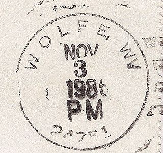
Wolfe is an unincorporated community in Mercer County, West Virginia, United States. Wolfe is located along West Virginia Route 102 at the Virginia border and is 0.5 miles (0.80 km) east-northeast of Pocahontas, Virginia. Wolfe had a post office, which closed on June 25, 2011.
Mohawk is an unincorporated community in McDowell County, West Virginia, United States. Mohawk is 6 miles (9.7 km) west-northwest of Iaeger. Mohawk had a post office, which opened on December 8, 1903, and closed on June 27, 2009. The community was named after the Mohawk Indians.

Monterville is an unincorporated community in Randolph County, West Virginia, United States. Monterville is 12.5 miles (20.1 km) southwest of Huttonsville. Monterville had a post office, which closed on June 20, 2009.
Norton is an unincorporated community in Randolph County, West Virginia, United States. Norton is 6.5 miles (10.5 km) west of Elkins, at the junction of County Route 151 and Corridor H. Norton had a post office, which closed on November 12, 2011. It is a former coal town operated by the West Virginia Coal and Coke Company from the early 1900s until the late 1950s. Besides the mine, the town was once home to a company store, a company bank, and the Norton Grade School. The denominationally unaffiliated Norton Community Church still serves the town.
Ellamore is an unincorporated community in Randolph and Upshur counties, West Virginia, United States. Ellamore is located on County Route 151 along the Middle Fork River, 8 miles (13 km) southeast of Buckhannon. Ellamore had a post office, which closed on July 11, 2009.
Dothan is an unincorporated community in Fayette County, West Virginia, United States. Dothan is located on West Virginia Route 612, 4 miles (6.4 km) west of Oak Hill. Dothan had a post office, which closed on October 5, 1991, when postmaster Lewis "Jackie" Toney retired.
Crawford is an unincorporated community in Lewis County, West Virginia, United States. Crawford is 11.5 miles (18.5 km) south-southeast of Weston. Crawford had a post office, which closed on January 21, 1989; it still has its own ZIP code, 26343.
Kanawha Falls is an unincorporated community in Fayette County, West Virginia, United States. Kanawha Falls is located on the east bank of the Kanawha River, 2 miles (3.2 km) southwest of Gauley Bridge and 0.6 miles (0.97 km) downstream from the waterfall of the same name. Kanawha Falls had a post office, which opened on March 26, 1856, and closed on November 2, 2002.
Blount is an unincorporated community in Kanawha County, West Virginia, United States. Blount is 11 miles (18 km) east-southeast of Charleston. Blount had a post office, founded by Harry and Stella Blount which opened on October 30, 1946, and closed on October 24, 2009.
Colcord is an unincorporated community in Raleigh County, West Virginia, United States. Colcord is 5.5 miles (8.9 km) east-southeast of Whitesville. Colcord had a post office, which closed on November 30, 2002. The community was named after the proprietor of the Colcord Coal Company.
Yolyn is an unincorporated community in Logan County, West Virginia, United States. Yolyn is 7 miles (11 km) east-southeast of Logan. Yolyn had a post office, which closed on March 3, 2007.
Saxon is an unincorporated community in Raleigh County, West Virginia, United States. Saxon is 12.5 miles (20.1 km) west of Beckley. Saxon had a post office, which closed on June 27, 2009.
Chauncey is a census-designated place (CDP) in Logan County, West Virginia, United States. Chauncey is located along West Virginia Route 44 and Island Creek, 5.5 miles (8.9 km) south of Logan. Chauncey had a post office, which opened on August 23, 1913, and closed on June 27, 2009. As of the 2010 census, its population is 283.
Centerville is an unincorporated community in Tyler County, West Virginia, United States. Centerville is located along West Virginia Route 18, 5.4 miles (8.7 km) southeast of Middlebourne. Centerville has a post office with ZIP code 26320; the post office uses the name Alma.
North is an unincorporated community in Mathews County, Virginia, United States. North is located on Virginia State Route 14 4.75 miles (7.64 km) west of Mathews. North has a post office with ZIP code 23128.
McCoy is an unincorporated community in Montgomery County, Virginia, United States. McCoy is 10.2 miles (16.4 km) west of Blacksburg. McCoy has a post office with ZIP code 24111. The McCoy post office was established in 1906.
Horsepen is an unincorporated community in Tazewell County, Virginia, United States. Horsepen is located along the West Virginia state line 5.4 miles (8.7 km) north of Tazewell, Virginia. Horsepen has a post office with ZIP code 24619.


