
Summers County is a county located in the U.S. state of West Virginia. As of the 2010 census, the population was 13,927. Its county seat is Hinton. The county was created by an act of the West Virginia Legislature on February 27, 1871 from parts of Fayette, Greenbrier, Mercer and Monroe counties and named in honor of George W. Summers (1804–68).

Monroe County is a county in the U.S. Commonwealth of Pennsylvania. As of the 2010 census, the population was 169,842. Its county seat is Stroudsburg. The county was formed from sections of Northampton and Pike counties. Named in honor of James Monroe, the fifth president of the United States, the county is located in northeastern Pennsylvania, along its border with New Jersey. Monroe County is coterminous with the East Stroudsburg, PA Metropolitan Statistical Area. It also borders the Wyoming Valley, the Lehigh Valley and has connections to the Delaware Valley, being a part of Philadelphia's Designated Media Market.
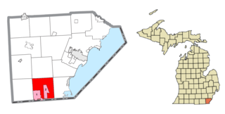
Bedford Township is a civil township of Monroe County in the U.S. state of Michigan. As of the 2010 census, the township population was 31,085.

Bridgeport is a census-designated place (CDP) in and the county seat of Mono County, California, United States. It lies at an elevation of 6463 feet in the middle of the Bridgeport Valley. Bridgeport is located at the intersection of U.S. Route 395 and State Route 182. The population was 575 at the 2010 census.

Milan is a city in Monroe and Washtenaw counties in the U.S. state of Michigan. The population was 5,836 at the 2010 census.

Sterling, Virginia refers most specifically to a census-designated place (CDP) in Loudoun County, Virginia, United States. The population of the CDP as of the 2010 United States Census was 27,822. The CDP boundaries are confined to a relatively small area between Virginia State Route 28 on the west and Virginia State Route 7 on the northeast, excluding areas near SR 606 and the Dulles Town Center.
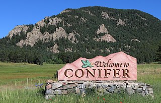
Conifer is an unincorporated community in Jefferson County, Colorado, United States. Conifer is located along U.S. Route 285 in the foothills west of Denver.
Heathsville is a census-designated place (CDP) in and the county seat of Northumberland County, Virginia, United States. Heathsville is the easternmost county of the Northern Neck of Virginia, which was the birthplace of three of the first five Presidents of the United States - George Washington, James Madison, and James Monroe. It is the county seat of Northumberland County, and has housed four county courthouses since the first was built in 1663.

Aldie is an unincorporated community and census-designated place (CDP) located between Chantilly and Middleburg in Loudoun County, Virginia, United States. The historic village of Aldie is located on the John Mosby Highway in a gap between the Catoctin Mountains and Bull Run Mountains, through which the Little River flows. Aldie traditionally serves as the gateway to the Loudoun Valley and beyond.

Weimar is an unincorporated community in Placer County, California, located in the Sacramento area. Weimar is located 4.5 miles (7.2 km) south-southwest of Colfax. As of 2010, its population is 209.
Beulah is an unincorporated community and a post office located in Pueblo County, Colorado, United States. The Beulah Post Office has the ZIP code 81023. Beulah is a part of the Beulah Valley CDP. Beulah lies along State Highway 78 about 21 miles southwest of Pueblo, in the foothills of the Wet Mountains.

Hannibal is a census-designated place in eastern Ohio Township, Monroe County, Ohio, United States. It has a post office with the ZIP code 43931. As of the 2016 estimate, it had a population of 451.

Oak Hill is a suburban unincorporated community located in Fairfax County, Virginia, United States.

Branchland is an unincorporated community in western Lincoln County, West Virginia, United States. It lies along West Virginia Route 10, southwest of the town of Hamlin, the county seat of Lincoln County. Its elevation is 597 feet (182 m). It has a post office with the ZIP code 25506. Raccoon Creek Road is one of the more popular ways of transportation through the area. Branchland Post Office serves addresses within Sheridan Magisterial District of Lincoln County as well as addresses in southern Cabell County and eastern Wayne County, West Virginia.

South Dennis is an unincorporated community located within Dennis Township in Cape May County, New Jersey, United States. It is part of the Ocean City Metropolitan Statistical Area. Its postal ZIP Code is 08245. The post office was established in 1873, with Robert Hutchinson as the first postmaster.
Lindside is an unincorporated community in Monroe County, West Virginia, United States. Lindside is located on U.S. Route 219, northeast of Peterstown. Lindside has a post office with ZIP code 24951.
Frankford is an unincorporated community in Greenbrier County, West Virginia, United States. Frankford is located on U.S. Route 219, south of Falling Spring and north of Maxwelton. Frankford has a post office with ZIP code 24938.
Lorentz is an unincorporated community in Upshur County, West Virginia, United States. Lorentz is located on U.S. routes 33 and 119, 4 miles (6.4 km) west-northwest of Buckhannon. Lorentz has a post office with ZIP code 26229.

Skipwith is an unincorporated community in old Bluestone Township, Mecklenburg County, Virginia, United States. It is located between Chase City and Clarksville, west-northwest of the county seat at Boydton. The community was named for local members of the Skipwith family, related to colonial Virginia Skipwith families which began arriving from English baronial estates in the 1650s. The surname Skipwith is derived from Old English "sceap" (sheep) and Old Norse "vath". One ancient Skipwith coat of arms is blazoned "Argent, three bars Gules, in chief a greyhound courant Sable."

Kresgeville is an unincorporated community in Monroe County, Pennsylvania, United States. Kresgeville is located on U.S. Route 209, 6 miles (9.7 km) west-southwest of Brodheadsville. Kresgeville has a post office with ZIP code 18333, which opened on January 5, 1846.


