Arminghall is a village and former civil parish, now in the parish of Caistor St Edmund and Bixley, in the South Norfolk district, in the county of Norfolk, England. It is around 3 miles (4.8 km) southeast of Norwich. Most of the houses in the village are located close to the church, which lies just west of the B1332 road from Norwich to Poringland. Syfer Technology, an electronic components manufacturer, is based at Old Stoke Road, close to the River Tas. In 1931 the parish had a population of 108.
Shereford is a small village and former civil parish, now in the parish of Dunton, in the North Norfolk district, in the county of Norfolk, England. It is located about 4 kilometres (2 mi) west of the market town of Fakenham. It lies on the east bank of the River Wensum facing Dunton across the river. In 1931 the parish had a population of 97. On 1 April 1935 the parish was abolished to form Dunton.

Keswick is a village and former civil parish, now in the parish of Keswick and Intwood, in the South Norfolk district, in the county of Norfolk, England. It is situated some 3 miles (4.8 km) to the south of the city of Norwich. It should not be mistaken for the coastal settlement of Keswick, near Bacton, which is also in Norfolk.

Thurgarton is a village and former civil parish, now in the parish of Aldborough and Thurgarton, in the North Norfolk district of the county of Norfolk, England. It lies 6½ miles north of Aylsham and 5½ miles south-west of Cromer, and was once part of the North Erpingham hundred. In 1931 the parish had a population of 186.

West Newton is a village and former civil parish, now in the parish of Sandringham, in the King's Lynn and West Norfolk district, in the north of the county of Norfolk, England. The village is 1 kilometre (0.62 mi) south of Sandringham, 11 kilometres (7 mi) north of the town of King's Lynn and 60 kilometres (37 mi) north-west of the city of Norwich. In 1931 the parish had a population of 198.

Wolferton is a village and former civil parish, now in the parish of Sandringham, in the King's Lynn and West Norfolk district, in the county of Norfolk, England. It is 2 miles west of Sandringham, 7½ miles north of King's Lynn and 37¼ miles northwest of Norwich. In 1931 the parish had a population of 185. On 1 April 1935 the parish was abolished and merged with Sandringham.
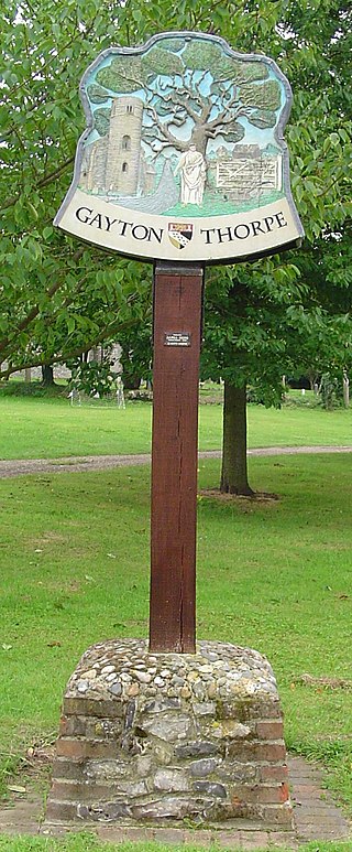
Gayton Thorpe is a village and former civil parish, now in the parish of Gayton, in the King's Lynn and West Norfolk district, in the county of Norfolk, England. The village is located 7.1 miles (11.4 km) south-east of King's Lynn and 31 miles (50 km) north-west of Norwich. In 1931 the parish had a population of 136.

Tatterford is a village and former civil parish, now in the parish of Tattersett, in the North Norfolk district, in the county of Norfolk, England. The village is 4.8 miles south west of the town of Fakenham, 30.3 miles north west of Norwich and 112 miles north north east of London. The nearest railway station is at Sheringham for the Bittern Line which runs between Sheringham, Cromer and Norwich. The nearest airport is Norwich International Airport. In 1931 the parish had a population of 66.

South Raynham is a village and former civil parish, now in the parish of Raynham, in the North Norfolk district, in the county of Norfolk, England. It is situated on the A1065 road some 5 miles (8.0 km) SW of Fakenham. The River Wensum flows nearby. In 1931 the parish had a population of 94.

East Raynham is a village and former civil parish, now in the parish of Raynham, in the North Norfolk district, in the county of Norfolk, England. It is located on the A1065 some 4 miles (6.4 km) south-west of Fakenham. The River Wensum flows close to the village. The village can trace its origins back and before the Domesday survey of 1086 when it was known as Reinham. Raynham, Massachusetts took the village's name at its incorporation in 1731 at the time of Charles Townshend, 2nd Viscount Townshend (1674–1738), Leader of the House of Lords. In 1931 the parish had a population of 130.

Waxham is a village and former civil parish, now in the parish of Sea Palling, in the North Norfolk district, in the county of Norfolk, England. It lies on the north-east coast of the county. Buildings in the village include Waxham Hall, the 14th-century St. John's Church and the 16th-century Waxham Great Barn. Waxham Hall is reputedly haunted by the ghosts of six members of the Brograve family, all of whom died in battle. It is said that an 18th-century owner of the house once invited them all to dinner. Waxham Great Barn built about 1570, at 178 feet long is one of the largest barns of its age in the country. It has recently been restored and opened to the public. The village has an extensive beach backed by dunes. Many migrant birds pass through the area in spring and autumn and common cranes feed in fields near the village. In 1931 the parish had a population of 84.

Gaywood is an eastern suburb of King's Lynn, in the King's Lynn and West Norfolk district, in the county of Norfolk, England.

East Barsham is a village and former civil parish, now in the parish of Barsham, in the North Norfolk district, in the English county of Norfolk. In 1931 the parish had a population of 144. On 1 April 1935 the parish was abolished to form Barsham.

Houghton Saint Giles is a village and former civil parish, now in the parish of Barsham, in the North Norfolk district, in the English county of Norfolk. It has also been referred to as Houghton-le-Dale or Houghton-in-the-Hole. In 1931 the parish had a population of 142.

Sharrington is a village and former civil parish, now in the parish of Brinton, in the North Norfolk district, in the county of Norfolk, England. The village is laid out on the southern edge of the A148, 3.5 miles west of Holt. The village is 10 miles east-northeast of the town of Fakenham, 13.4 miles west-southwest of Cromer and 124 miles north-northeast of London. The nearest railway station is at Sheringham for the Bittern Line which runs between Sheringham, Cromer and Norwich. The nearest airport is at Norwich. In 1931 the parish had a population of 195. On 1 April 1935 the parish was abolished and merged with Brinton.

Larling is a village and former civil parish, now in the parish of Roudham and Larling, in the Breckland district, in the county of Norfolk, England. The village is 8.5 miles east north east of Thetford, 21.4 miles west south west of Norwich and 94 miles north east of London. In 1931 the parish had a population of 159.

Forest Hill is a village in the civil parish of Forest Hill with Shotover, in the South Oxfordshire district, in Oxfordshire, England, about 4.5 miles (7 km) east of Oxford. The village which is about 330 feet (100 m) above sea level is on the northeastern brow of a ridge of hills. The highest point of the ridge is Red Hill, which rises to 440 feet (130 m) just south of the village. The 2011 Census recorded Forest Hill with Shotover's population as 856.
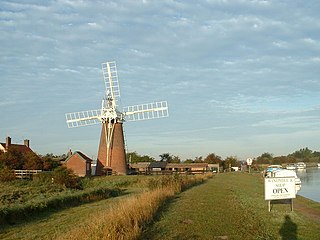
Tunstall is a village and former civil parish, now in the parish of Halvergate, in the Broadland district of Norfolk, England. It lies some 14 miles (22.5 km) south-east of Norwich alongside the River Bure. In 1931 the parish had a population of 94.

Limpenhoe is a village and former civil parish, now in the Cantley, Limpenhoe and Southwood, in the Broadland district, in the county of Norfolk, England. It is located on the north bank of the River Yare, between the villages of Cantley and Reedham, 8.2 miles (13.2 km) south-west of Great Yarmouth and 10.8 miles (17.4 km) south-east of Norwich. In 1931 the parish had a population of 156.
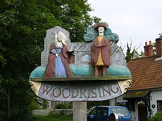
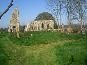
Woodrising is a village and former civil parish, now in the parish of Cranworth, in the Breckland district, in the county of Norfolk, England. The village of Woodrising is south of Dereham. In 1931 the parish had a population of 103.