Related Research Articles

Southcourt is a housing estate in Aylesbury, Buckinghamshire, England. Building commenced in the early 1920s through to the mid-1930s and only stopped because of the Second World War. It was turned into a post war housing estate during the years of 1946 and 1955. The area is named after the pig farm over which the housing estate was built.

Filton is a suburban town and civil parish in South Gloucestershire, England, north of the City of Bristol and approximately 5.5 miles (9 km) from the city centre. The town centres upon Filton Church, which dates back to the 12th century and is a Grade II listed building.

Billesley is a ward within the council constituency and parliamentary constituency of Selly Oak, Birmingham, England. It is 7 kilometres (4 mi) south of the city centre and includes the area of Billesley and much of Yardley Wood as well as the Hollybank Road area of Kings Heath. It is contiguous with the Birmingham wards of Highter's Heath on the south-west, Brandwood and Kings Heath on the west, Moseley on the north and Hall Green South on the east. To the south-east is the Shirley West ward of Solihull.

Quinton, situated in the west of Birmingham, is a ward that is approximately 5 miles from Birmingham city centre. Between the Amber Tavern and Quinton church, the southern side of the Hagley Road is part of the city of Birmingham and the northern side is part of the metropolitan borough of Sandwell. Quinton, along with Bartley Green, Harborne and Edgbaston are a part of the Birmingham Edgbaston constituency. The whole of Quinton is covered by the B32 postal district.

New Forest East is a constituency represented in the House of Commons of the UK Parliament since 1997 by Julian Lewis, a member of the Conservative Party.

Stoke-on-Trent Central is a constituency in Staffordshire. It has been represented by Jo Gideon of the Conservative Party since the general election of 2019.

Stoke-on-Trent North is a constituency represented in the House of Commons of the UK Parliament since 2019 by Jonathan Gullis, a member of the Conservative Party.
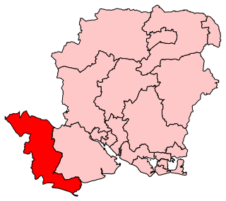
New Forest West is a constituency represented in the House of Commons of the UK Parliament since 1997 by Desmond Swayne, a Conservative.

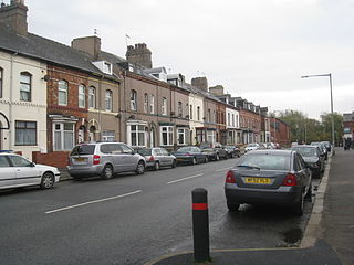
Smallthorne is an area in the city of Stoke-on-Trent in Staffordshire, England. It is in the north-east of the city, near Burslem. Smallthorne borders Bradeley and Chell in the north, Norton-in-the-Moors in the east, Sneyd Green in the south, and Burslem in the west.

Blackley and Broughton is a constituency represented in the House of Commons of the UK Parliament by Graham Stringer. He was first elected in 1997 for the former Manchester Blackley and prior to this was Leader of Manchester City Council. The constituency covers north Manchester and east Salford.

Sneyd Green is an area in the city of Stoke-on-Trent in Staffordshire, England. It is in the north-east of the city, approx. 1.5 miles (2.4 km) from Hanley. Sneyd Green borders Smallthorne in the north, Milton in the east, Birches Head in the south, and Cobridge in the west.
Smallthorne Urban District was an urban district in Staffordshire. It was initially formed of the Smallthorne civil parish. In 1904 the Chell and Milton civil parishes were added. It was abolished in 1922 with the bulk of it becoming part of the county borough of Stoke-on-Trent.
Baddeley Green is an area of Stoke-on-Trent, Staffordshire, England.

Milton is located in Stoke on Trent, Staffordshire, England. It is mainly situated between the A5009 and A53 roads. It shares its borders with Light Oaks, Baddeley Green, Sneyd Green, and Abbey Hulton.
Parkside is an area and electoral ward of Barrow-in-Furness, Cumbria, England. It is bordered by Hindpool, Ormsgill, Hawcoat, Newbarns and Risedale and had a population of 5,742 in 2001, reducing to 5,584 at the 2011 Census. It is one of the town's most centralised wards and contains Barrow's main park, as well as the newly established Furness Academy. Abbey Road - Barrow's principal road runs down the entire western side of Parkside. The majority of housing to the west of Abbey Road is terraced and semi-detached, whilst the eastern side of Parkside is predominantly parkland and fields with the exception of some semi and detached housing. There are a number of place of worship in Parkside including Abbey Road Baptist Church, Spring Mount Christian Fellowship and Trinity Church Centre. Barrow's first synagogue was founded in 1902 on Abbey Road although it closed less than twenty years later.

Abbey is an electoral ward in the city of Derby, England. It includes the areas of California, Rowditch, and St Lukes, as well as a small part of Normanton. Part of its eastern boundary is formed by Abbey Street, from which the ward takes its name. It is a largely residential area, with a mixture of Victorian terraced housing and 20th century suburban development. The population was 15,334 in 2011.
Baddeley Edge is a small hamlet in Stoke-on-Trent. Baddeley Edge is part of the Abbey Green ward, which covers the areas of Baddeley Green, Milton, Abbey Hulton and Light Oaks. Located in the hamlet is a Primitive Methodist Chapel which was built in 1874.

The Stoke-on-Trent Green Belt is a green belt environmental and planning policy that regulates the rural space throughout mainly the West Midlands region of England. It is contained within the counties of Cheshire and Staffordshire. Essentially, the function of the designated area is to prevent surrounding towns and villages within the Stoke-on-Trent conurbation from further convergence. It is managed by local planning authorities on guidance from central government.