Cliffe Vale, Staffordshire

Last updated

Cliffe Vale
Cliffe Vale Pottery.JPG
The Cliffe Vale Pottery building in 2015
Staffordshire UK location map.svg
Red pog.svg
Cliffe Vale
Location within Staffordshire
Population400 
OS grid reference SJ872465
Unitary authority
Ceremonial county
Region
Country England
Sovereign state United Kingdom
Post town STOKE-ON-TRENT
Postcode district ST4
Dialling code 01782
Police Staffordshire
Fire Staffordshire
Ambulance West Midlands
UK Parliament
List of places
UK
England
Staffordshire
53°00′58″N2°11′29″W / 53.0161°N 2.1915°W / 53.0161; -2.1915

Cliff Vale is a district of the city of Stoke-on-Trent, and lies to the immediate south of Etruria and just east of Basford and Hartshill. Cliffe Vale is in the valley of the Fowlea Brook, now better known as Etruria Valley. There are industrial and employment uses along the A500, and new residential developments along the Trent and Mersey Canal. The Shelton New Road (B5045) passes through from east to west. The area is sometimes called Cliff Vale (with no 'e') by the city council, and is part of the Hartshill electoral ward.

Contents

History

The Roman road called Rykeneld Street passed directly through the Cliffe Vale area, although the exact route it ran along is unknown. Cliffe Vale takes its name from having been the 'Hay of Clive', part of a Norman deer hunting park that survived as such well into the 15th century...

"Great woods and forests are described in 1485, when Cliffe Ville (now Cliff Vale) was known as the King's Park or wood, fringed by Witton, or Winton Wood." [1]

The lower Cliffe Vale section of the park - between Shelton Old Road and Etruria Road - was probably deforested sometime in the 15th century. The more elevated core of the hunting park became a landed estate and farm, and it is marked on the 1st edition six-inch (152 mm) Ordnance Survey map (circa 1860) as "Cliff Ville". The park survived into the 20th century as a large wooded area, and after being partly a farm this is now run as a local nature reserve under the name of Hartshill Park. The modern Hartshill Park overlooks the modern Cliffe Vale area.

The Trent and Mersey Canal was cut north–south through Cliffe Vale in the 1770s. What is now the West Coast Main Line railway track was built in the mid-1850s. There was a Cliffe Vale railway station, but this closed in 1865. In the Victorian era the area toward the canal specialised in carpentry, making wooden railway carriages at Cockshute sidings and narrowboats at the canal, while the area west of the train lines (Brick Kiln Lane) specialised in brick making.

A new ideal 'model' factory, Cliffe Vale Pottery, was built by T.W. Twyford in 1887, and his factory manufactured the world's first flushing toilets [2] and other innovative sanitaryware for over 100 years. The Twyfords works closed in 1994, and moved to a purpose-built factory at Alsager. The nearby Armitage Shanks sanitaryware pottery, established at the Excelsior Works in Cliffe Vale from 1912, closed in 2007 and moved to a new factory at Middlewich. This closure brought to an end 120 years of sanitary innovation at Cliffe Vale, innovations that rapidly spread around the world and which have changed the way billions of people live.

The railway sidings and buildings at Cliffe Vale were used as the winter quarters for the world's biggest circus, Barnum & Bailey, from 1897 until 1911 when Twyfords expanded and the circus had to move elsewhere.

Cliffe Vale today

The building of the A500 dual carriageway and Queensway in the 1970s bisected the area, effectively making the Brick Kiln Lane area into part of Basford, and blighting the run-down terraced housing that remained along Garner Street to the east of the A500. 160 residential terraced houses in Garner Street were demolished between 2002 and 2005, since they were deemed to be too near to the A500 road. This effectively removed the bulk of the residential population of Cliffe Vale.

In the 1990s and 2000s the canal and towpath was regenerated for boaters and cyclists, with the towpath becoming National Cycle Route No.5 and providing easy off-road access to Stoke-on-Trent railway station less than a mile away.

By 2007 there was a new 184-apartment canalside residential development on the defunct Twyfords site to the east of the A500, called Lock 38. New housing developments mean that Cliffe Vale will once again have a significant residential population by 2008, of around 400 people living in an 'urban village' of upmarket apartments.

Industry today consists of: Imerys, located on the Cliffe Vale rail terminal (aka Newcastle Junction), which handles three freight trains per week of Cornish china clay and thus supplies most Stoke-on-Trent potteries with clay; a large timber yard and timber wholesaler; the making of hand-made oak furniture; a dairy produce processing unit; a small estate of light industrial units in restored Victorian train sheds of the former North Staffordshire Railway. Major employers less than a mile away include the main campus of Staffordshire University and the University Hospital of North Staffordshire.

At the eastern edge of Cliffe Vale is the 29-acre Hanley Cemetery (1860 to present-day), originally the south part of the grounds of Chatterley Hall. It is still an active cemetery, and is run as a nature conservation area.

Further reading

Related Research Articles

<span class="mw-page-title-main">Staffordshire</span> County of England

Staffordshire is a landlocked ceremonial county in the West Midlands of England. It borders Cheshire to the north-west, Derbyshire to the east, Warwickshire to the south-east, the West Midlands county and Worcestershire to the south, and Shropshire to the west. The largest settlement is the city of Stoke-on-Trent; the county town is Stafford.
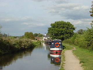
<span class="mw-page-title-main">Trent and Mersey Canal</span> Canal in England

The Trent and Mersey Canal is a 93+12-mile (150 km) canal in Derbyshire, Staffordshire and Cheshire in north-central England. It is a "narrow canal" for the vast majority of its length, but at the extremities to the east of Burton upon Trent and north of Middlewich, it is a wide canal.

<span class="mw-page-title-main">Stoke-upon-Trent</span> Human settlement in England

Stoke-upon-Trent, also called Stoke, is one of the six towns that along with Hanley, Burslem, Fenton, Longton and Tunstall form the city of Stoke-on-Trent, in Staffordshire, England.

<span class="mw-page-title-main">Stoke-on-Trent</span> City and unitary authority in England

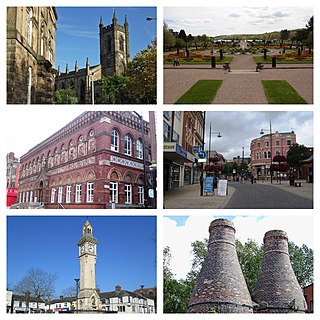
Stoke-on-Trent is a city and unitary authority area in Staffordshire, England, with an area of 36 square miles (93 km2). In 2021, the city had an estimated population of 258,400. It is the largest settlement in Staffordshire and is surrounded by the towns of Newcastle-under-Lyme, Alsager, Kidsgrove and Biddulph, which form a conurbation around the city.

<span class="mw-page-title-main">Hanley</span> Human settlement in England

Hanley is one of the six towns that, along with Burslem, Longton, Fenton, Tunstall and Stoke-upon-Trent, amalgamated to form the City of Stoke-on-Trent in Staffordshire, England.

<span class="mw-page-title-main">A500 road</span> Road in England

The A500 is a major primary A road in Staffordshire and Cheshire, England. It is dual carriageway for most of its length and connects Nantwich, junctions 16 and 15 of the M6 motorway with the city of Stoke-on-Trent. It is 19 miles (31 km) long.

<span class="mw-page-title-main">Burslem</span> Human settlement in England

Burslem is one of the six towns that along with Hanley, Tunstall, Fenton, Longton and Stoke-upon-Trent form part of the city of Stoke-on-Trent in Staffordshire, England. It is often referred to as the "mother town" of Stoke on Trent.

<span class="mw-page-title-main">Middleport, Staffordshire</span> Human settlement in England

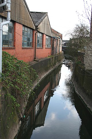
Middleport is a residential and industrial district in the city of Stoke-on-Trent, England. Middleport lies to the west of Burslem, between Burslem and the Newcastle-under-Lyme district of Porthill. To the north is Tunstall and to the south Cobridge and Etruria. Middleport conjoins Longport.

Thomas William Twyford (1849–1921) was an English pottery manufacturer. He invented the single piece, ceramic flush toilet. At the time of Twyford's death he was recognised as a leading pioneer in the application of principles of hygiene to sanitary appliances.

<span class="mw-page-title-main">Stoke-on-Trent Central (UK Parliament constituency)</span>

Stoke-on-Trent Central is a constituency in Staffordshire. It has been represented by Jo Gideon of the Conservative Party since the general election of 2019.

Etruria is a suburb of Stoke-on-Trent, Staffordshire, England.

<span class="mw-page-title-main">Tunstall, Staffordshire</span> Human settlement in England

Tunstall is one of the six towns that, along with Burslem, Longton, Fenton, Hanley and Stoke-upon-Trent, amalgamated to form the City of Stoke-on-Trent in Staffordshire, England. It was one of the original six towns that federated to form the city. Tunstall is the most northern, and fourth largest town of the Potteries. It is situated in the very northwest of the city borough, with its north and west boundaries being the city limit. It stands on a ridge of land between Fowlea Brook to the west and Scotia Brook to the east, surrounded by old tile-making and brick-making sites, some of which date back to the Middle Ages.

<span class="mw-page-title-main">Barlaston</span> Human settlement in England

Barlaston is a village and civil parish in the borough of Stafford in the county of Staffordshire, England. It is roughly halfway between the city of Stoke-on-Trent and the small town of Stone. According to the 2001 census the population of the parish was 2,659, rising at the 2011 Census to 2,858.

Twyford Bathrooms is a manufacturer of bathroom fixtures based in Alsager, Cheshire, England.

Shelton is an area of the city of Stoke-on-Trent in Staffordshire, England, between Hanley and Stoke-upon-Trent.

<span class="mw-page-title-main">Longport, Staffordshire</span> Human settlement in England

Longport is an area of Stoke-on-Trent, England. It is the location for Longbridge Hayes industrial estate.

Basford is a suburb which sits on high ground between Newcastle-under-Lyme and Stoke-on-Trent in Staffordshire, England.

<span class="mw-page-title-main">Hartshill Park</span> Nature reserve in Stoke-on-Trent, England

Hartshill Park is a large nature reserve stretching along the western edge of the city of Stoke-on-Trent, England. The park is a patchwork of different habitats, including five ponds. It is notable for being part of a Norman deer hunting park that has survived as open space into the modern era. It is a local nature reserve.

Rykeneld Street or Ryknield Street was a Roman road which ran through the northern Midlands of England from Deva (Chester) to Derventio (Derby) via what is now Stoke-on-Trent. It is not to be confused with the Icknield Street. It has in the past also been called by Victorian antiquarians the "Via Devina". The territory traversed would have been that of the Cornovii.

<span class="mw-page-title-main">Fowlea Brook</span> Stream in Staffordshire, England

Fowlea Brook rises in Staffordshire and flows through the northern parts of Stoke-on-Trent, England. It is a tributary stream of the River Trent, and is 6 miles (9.7 km) long.

References

  1. Ernest James Dalzell Warrillow, History of Etruria, Staffordshire, England, 1760-1951, 1952, page 10.
  2. "Twyford Bathrooms - History". Archived from the original on 9 June 2007.