Charminster, Bournemouth

Last updated

Charminster
Charminster, Bournemouth (280347) (16063154507).jpg
Charminster in 1992.
Dorset UK location map.svg
Red pog.svg
Charminster
Location within Dorset
Unitary authority
Ceremonial county
Region
Country England
Sovereign state United Kingdom
Post town BOURNEMOUTH
Postcode district BH8
Dialling code 01202
Police Dorset
Fire Dorset and Wiltshire
Ambulance South Western
UK Parliament
List of places
UK
England
Dorset
50°44′18″N1°51′51″W / 50.73833°N 1.86417°W / 50.73833; -1.86417

Charminster is a residential and commercial suburb of Bournemouth in Dorset, situated between the suburbs of Springbourne (to the south-east) and Winton (to the north-west). It was incorporated into the County Borough of Bournemouth in 1901.

Contents

View from St Francis of Assisi church Charminster Bournemouth.jpg
View from St Francis of Assisi church
St Francis from the west Charminster, St. Francis from the west - geograph.org.uk - 503838.jpg
St Francis from the west

Origins

Although there are no known references to Charminster before 1805, the name and settlement predate the nearby districts of Springbourne and Winton by several decades. The first known reference to the district comes in the Christchurch Inclosure Award of 1805, in which a 'Charminster Lane' is cited, along with two plots of land called 'Charminster' in the possession of Matthew Aldridge, the owner of Muscliff Farm. [1] The earliest reference to any inhabitants comes in the 1841 census, in which three families are listed at Charminster: Paul Fletcher, a tinker (with his wife and seven children); John Burridge, a bricklayer (with his wife and four children); and Richard Watton, a labourer (with his wife and ten children). [2] By this stage much of the land in the district was owned by James Harris, 3rd Earl of Malmesbury, who had received 150 acres here under the Christchurch Inclosure Award; he is commemorated in the Malmesbury Park Estate, south-east of the present Charminster Road. [3] It is not known why the name 'Charminster' was applied to this district. A. D. Mills suggests it was a straightforward appropriation of Charminster near Dorchester, which was recorded as a toponym from the Domesday Survey onwards, and which translates as 'church on the River Cerne'; [4] why it should have been applied to this part of Bournemouth, however, remains unclear.

Development

In the 1860s the Earl of Malmesbury, working with the architect and designer Christopher Crabb Creeke, drew up plans to build over Charminster. These plans were suspended in 1866, however, when the Tories returned to power, Malmesbury taking up the position of Lord Privy Seal in the 14th Earl of Derby's third administration. [5] Consequently, the 1870 Ordnance Survey map shows little more than tumuli and brickfields at Charminster, while the suburb of Springbourne was developing independently to the south. [6] The first modern dwellings in Charminster were built around 1880 after Malmesbury's retirement from politics. His nephew and legatee, Edward Harris, 4th Earl of Malmesbury, continued to develop the area, opening up what became known as the Lansdowne Park Estate between Heron Court Road and Fortescue Road. [7]

Church of the Annunciation

One consequence of the development of the Malmesbury Park Estate was the provision of a church just to the north, in the plot now bordered by Charminster Road, Richmond Wood Road and Richmond Park Avenue. This was The Church of the Annunciation, designed by the 26-year-old Giles Gilbert Scott with George Frederick Bodley as joint architect; the latter had already overseen the young Scott's work on Liverpool Cathedral. [8] The builders were McWilliam & Son of Bournemouth, and the building was completed in 1907. [9] It was originally put up as a chapel of ease to the Church of the Sacred Heart, to meet the needs of Catholics from the Winton and Malmesbury Park areas who were unable to travel to the latter church in central Bournemouth. [10]

Municipal facilities

A fresh spate of housebuilding took place north of Alma Road and Richmond Park Road in the 1920s, resulting (amongst other things) in the provision of Charminster Library, designed by F. P. Dolamore and opened in 1932. [11] A further development in this area was the relocation in 1939-40 of the town grammar school, Bournemouth School, from its original premises in Portchester Road to a larger site along the newly-cut East Way. This was the result of a petition presented to Bournemouth Borough Council, owners of the latter site, by a group of the school's alumni. [12] An attendee of the school around this time was the future actor Charles Gray, who grew up in Howard Road. [13] Another school, a secondary modern, was added on the south side of East Way in the post-war period to meet the needs of the expanding populace. This was Summerbee School, designed by the borough architect John Burton and named after Alderman Frank Summerbee, who sat on the town's education committee; it was opened by Cllr. Harry Mears in September 1953. [14] The school was later renamed The Bishop of Winchester School and was reopened in 2010 as The Bishop of Winchester Academy. [15]

Politics

Charminster is part of the Moordown ward for elections to Bournemouth, Christchurch and Poole Council which elect two councillors.

Charminster is part of the Bournemouth East parliamentary constituency, for elections to the House of Commons of the United Kingdom.

Related Research Articles

<span class="mw-page-title-main">Bournemouth</span> Town in Dorset, England

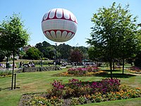
Bournemouth is a coastal resort town on the south coast in the Bournemouth, Christchurch and Poole unitary authority area in the ceremonial county of Dorset, England. The town's urban subdivision had a population of 187,503 at the 2011 census making it the largest town in the county; the town is part of the South East Dorset conurbation, which has a population of 465,000.

<span class="mw-page-title-main">Christchurch, Dorset</span> Town and civil parish in England

Christchurch is a town and civil parish on the south coast of Dorset, England. The parish had a population of 31,372 in 2021. It adjoins Bournemouth to the west, with the New Forest to the east. Part of the historic county of Hampshire, Christchurch was a borough within the administrative county of Dorset from 1974 until 2019, when it became part of the new Bournemouth, Christchurch and Poole unitary authority.

<span class="mw-page-title-main">Boscombe</span> Suburb of Bournemouth, England

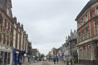
Boscombe is a suburb of Bournemouth, England. Historically in Hampshire, but today in Dorset, it is located to the east of Bournemouth town centre and west of Southbourne.

<span class="mw-page-title-main">Frederick Charles Riggs</span> Recipient of the Victoria Cross

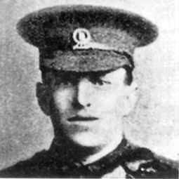
Frederick Charles Riggs was an English recipient of the Victoria Cross, the highest and most prestigious award for gallantry in the face of the enemy that can be awarded to British and Commonwealth forces.

<span class="mw-page-title-main">Bournemouth East (UK Parliament constituency)</span> UK Parliament constituency in England since 1974

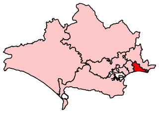
Bournemouth East is a parliamentary constituency in Dorset represented in the House of Commons of the UK Parliament since 2005 by Tobias Ellwood, a Conservative.

<span class="mw-page-title-main">Holdenhurst</span> Human settlement in England

Holdenhurst is a small isolated village situated in the green belt land of the north-east suburbs of Bournemouth, England. The village comprises fewer than 30 dwellings, two farms and the parish church. There are no shops and few local facilities in the village.

<span class="mw-page-title-main">Springbourne</span> Human settlement in England

Springbourne is a suburb of Bournemouth in Dorset, England. It occupies the north-east part of the main built-up area, north of Boscombe. Its formal boundaries are Northcote Road to the west, the Wessex Way (A338) to the north, Ashley Road to the east, and the railway line to the south.

<span class="mw-page-title-main">Bournemouth Borough Council</span>

Bournemouth Borough Council was the local authority of Bournemouth in Dorset, England and ceased to exist on 1 April 2019. It was a unitary authority, although between 1974 and 1997 it was an administrative district council with Dorset. Previously most of the borough was part of Hampshire.

Winton is a suburb of Bournemouth in Dorset, England. It lies approximately 1 mile (1.6 km) north of Bournemouth town centre, along Wimborne Road. Winton is to the east of Wallisdown, Victoria Park and Talbot Woods and south of Moordown.

<span class="mw-page-title-main">Ensbury Park</span> Human settlement in England

Ensbury Park is a mainly residential suburb of Bournemouth, in Dorset, England. It includes the housing estate of Slades Farm and lies within the ward district of Northbourne and Redhill.

The Bishop of Winchester Academy is a co-educational secondary school and sixth form with academy status, located in the Charminster area of Bournemouth in the English county of Dorset.

Moordown is a suburb of Bournemouth, situated in the northern part of the borough. It was incorporated into the borough of Bournemouth in 1901, having previously been part of the Christchurch rural district.

<span class="mw-page-title-main">Richmond Park, Bournemouth</span> Area of Bournemouth, England

Richmond Park is an area of Bournemouth, Dorset, England. The area is north of Richmond Hill and Springbourne, east of Charminster, west of Queen's Park and south of Winton and Queen's Park.

<span class="mw-page-title-main">Winton East (ward)</span> Election ward in Bournemouth, Dorset, England

Winton East is a ward in Bournemouth, Dorset. Since 2019, the ward has elected 2 councillors to Bournemouth, Christchurch and Poole Council.

<span class="mw-page-title-main">St Alban's Church, Bournemouth</span> Church in Bournemouth, UK

St Alban's Church is a Grade II listed Gothic Revival Anglican church in the Charminster area of Bournemouth, Dorset, England. The church stands across Charminster Road from the Church of the Annunciation.

References

  1. M. Stead, Charminster (Bournemouth Library, 2008), p. 1.
  2. M. Stead, Charminster, p. 2.
  3. M. Stead, Charminster, p. 3.
  4. A. D. Mills, Dorset Place-Names (Wimborne: Roy Gasson Associates, 1986), p. 42.
  5. M. Stead, Charminster, pp. 3-4.
  6. 'M. Stead, Charminster, p. 4.
  7. M. Stead, Charminster, p. 5.
  8. "Annunciation Church in Bournemouth". Boscombecatholics.net. Archived from the original on 3 December 2013. Retrieved 29 November 2013.
  9. A. Webb, The Churches of Bournemouth (Bournemouth: H & W, 1910), p. 103.
  10. A. Webb, The Churches of Bournemouth.
  11. The Bournemouth Daily Echo, 8 January 1932.
  12. D. G. Hilliam, Bournemouth School 1901-2000 (Bournemouth School, 2000), p. 42.
  13. M. Stead, Charminster, p. 6.
  14. The Bournemouth Times & Directory, 11 September 1953.
  15. "IPTV Omni-Server". Tbows.co.uk. Archived from the original on 10 February 2009. Retrieved 29 November 2013.