Talbot Woods is an area of Bournemouth, Dorset, England. Talbot Woods is south of Talbot Village.
Talbot Woods is an area of Bournemouth, Dorset, England. Talbot Woods is south of Talbot Village.
Talbot Woods is known for its high house prices and affluent residents. [1]
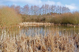
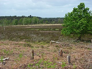
Talbot Heath nature reserve is in the area. Dog-walking is allowed though it is advised to keep them on a lead in the areas that a few cows are allowed to graze. It is designated as a Special Protection Area for its bird populations and a Special Area of Conservation for its reptile populations and heathland habitats, as well as being part of the Bourne Valley Site of Special Scientific Interest (SSSI), meaning it is legally protected. This influenced the decision of the Secretary of State for Communities and Local Government in 2012 to refuse planning permission for 378 new houses on the neighbouring farmland in Poole, as the RSPB and Natural England argued in a public inquiry that the Talbot Village Trust's proposed risk mitigation measures would not prevent harm to the heathland. [2]
Talbot Heath School [3] is in Talbot Woods.
Talbot Woods is part of the Talbot and Branksome Woods ward for elections to Bournemouth, Christchurch and Poole Council which elects three councillors. It is also part of the Bournemouth West constituency for elections to Westminster.

Poole is a coastal town and seaport on the south coast of England in the Bournemouth, Christchurch and Poole unitary authority area in Dorset, England. The town is 21 miles (34 km) east of Dorchester and adjoins Bournemouth to the east. Since 1 April 2019, the local authority is Bournemouth, Christchurch and Poole Council. The town had an estimated population of 151,500 making it the second-largest town in the ceremonial county of Dorset. Together with Bournemouth and Christchurch, the conurbation has a total population of nearly 400,000.

Studland is a village and civil parish on the Isle of Purbeck in Dorset, England. The village is located about 2 miles (3.2 km) north of the town of Swanage, over a steep chalk ridge, and 3 miles (4.8 km) south of the South East Dorset conurbation at Sandbanks, from which it is separated by Poole Harbour. The parish includes Brownsea Island within the harbour. In the 2011 census the parish had 182 households and a population of 425, though many of the houses in the village are holiday homes, second homes, or guest houses, and the village's population varies depending upon the season.

The Studland and Godlingston Heaths NNR is located on the Isle of Purbeck in the English county of Dorset. It borders Studland Bay on the south side of Poole Harbour, between the settlements of Swanage and Sandbanks. Extending to 631ha, it is owned and managed by the National Trust following the Bankes bequest of the Kingston Lacy estate. Studland & Godlingston Heath is designated as one of only 35 "spotlight reserves" in England by Natural England in the list of national nature reserves in England and is listed as a Site of Special Scientific Interest (SSSI).

Arne is a village and civil parish in Dorset, England, situated 4 miles (6.4 km) east of Wareham. The local travel links are located at Wareham railway station. Bournemouth International Airport is 11 miles (18 km) away. The main road through the village is Arne Road connecting Arne to Wareham. The village is situated on the Arne Peninsula, which protrudes into Poole Harbour opposite the town of Poole.

Bournemouth West is a parliamentary constituency in Dorset represented in the House of Commons of the UK Parliament since 2010 by Conor Burns, a Conservative.

Canford Heath is a suburb and area of heathland in Poole, Dorset, known for being the largest heathland in Dorset, and the largest lowland heath in the UK. It is also the name of the housing development built on the heathland in the 1960s, 1970s and 1980s. The area is split into two wards, and at the 2011 census the combined population of the two wards was 14,079.

Branksome Park is a suburb of Poole in Dorset, which adjoins Branksome, Dorset. The area covers approximately 360 acres (1.5 km2), mostly occupied by housing, and includes Branksome Chine which leads to the award-winning blue-flagged beaches of Poole.
Ebblake Bog is a 11.3-hectare (28-acre) biological Site of Special Scientific Interest in Dorset and Hampshire, located west of Ringwood. It is part of Dorset Heathlands Ramsar site and Special Protection Area, and of Dorset Heaths Special Area of Conservation,

Bournemouth Borough Council was the local authority of Bournemouth in Dorset, England and ceased to exist on 1 April 2019. It was a unitary authority, although between 1974 and 1997 it was an administrative district council with Dorset. Previously most of the borough was part of Hampshire.
Winton is a suburb of Bournemouth, in the Bournemouth, Christchurch and Poole district, in the ceremonial county of Dorset, England. It lies approximately 1 mile (1.6 km) north of Bournemouth town centre, along Wimborne Road. Winton is to the east of Wallisdown, Victoria Park and Talbot Woods and south of Moordown.

Talbot Village is located on the boundary of Bournemouth and Poole in Dorset, England.
Alderney is a suburb of the town of Poole in Dorset, England with a population of 11,196, increasing to 11,423 at the 2011 Census. Alderney is south of Wallisdown and west of Alder Hills.
Woolmer Forest is a 1,298.5-hectare (3,209-acre) biological Site of Special Scientific Interest south of Bordon in Hampshire and West Sussex. It is also a Special Area of Conservation and part of the Wealden Heaths Phase II Special Protection Area. Two areas are Nature Conservation Review sites, Grade I.

Warren Hill is the elevated part of Hengistbury Head in Dorset, England, overlooking Christchurch to the North and dominating Poole Bay to the West. With finds stretching back over 10,000 years, it is a site of international importance in terms of its archaeology and is scheduled both as an Ancient Monument, and a Local Nature Reserve. The head and its surroundings form part of the Christchurch Harbour Site of Special Scientific Interest. Wind-pruned hummocks of heather cover the plateau of the hill, which is accessible to walkers all year round providing excellent views of the surrounding area, as well as an interesting heathland ecosystem for students of nature.

The Dorset Heaths form an important area of heathland within the Poole Basin in southern England. Much of the area is protected.

Gore Heath is an area of coniferous woodland and open heathland forming part of Wareham Forest west of the Poole-Bournemouth conurbation in south Dorset, England. It is part of the Dorset Heaths and an SSSI.

Decoy Heath is an area of open heathland and bog forming part of Wareham Forest west of the Poole-Bournemouth conurbation in south Dorset, England. It is part of the Dorset Heaths.
Turbary Park is an area of West Howe, Bournemouth in Dorset. Turbary Park is south of Kinson and north of Wallisdown.

Alder Hills is a suburb in Dorset that crosses the boundaries of Bournemouth and Poole. It is south of Wallisdown, east of Alderney and north of Parkstone.
50°44.3′N1°54.1′W / 50.7383°N 1.9017°W
| | This Dorset location article is a stub. You can help Wikipedia by expanding it. |