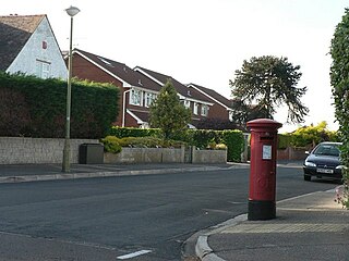
Townsend is a area of Bournemouth, Dorset. It is located in the suburbs along the north eastern boundary of the town and is close to the Royal Bournemouth Hospital. [1]
Townsend is a area of Bournemouth, Dorset. It is located in the suburbs along the north eastern boundary of the town and is close to the Royal Bournemouth Hospital. [1]
Townsend is a housing estate and was built in the mid 1970s. [2]
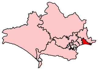
Townsend is part of the Muscliff and Strouden Park ward for elections to Bournemouth, Christchurch and Poole Council which elect three councillors. [3]
Townsend is part of the Bournemouth East parliamentary constituency, for elections to the House of Commons of the United Kingdom. [4]

Nottinghamshire is a landlocked county in the East Midlands region of England, bordering South Yorkshire to the north-west, Lincolnshire to the east, Leicestershire to the south, and Derbyshire to the west. The traditional county town is Nottingham, though the county council is based at County Hall in West Bridgford in the borough of Rushcliffe, at a site facing Nottingham over the River Trent.
Bournemouth East is a parliamentary constituency in Dorset represented in the House of Commons of the UK Parliament since 2005 by Tobias Ellwood, a Conservative.

Bournemouth West is a parliamentary constituency in Dorset represented in the House of Commons of the UK Parliament since 2010 by Conor Burns, a Conservative

Holdenhurst is a small isolated village situated in the green belt land of the north-east suburbs of Bournemouth, England. The village comprises fewer than 30 dwellings, two farms and the parish church. There are no shops and few local facilities in the village.

Bournemouth Borough Council was the local authority of Bournemouth in Dorset, England and ceased to exist on 1 April 2019. It was a unitary authority, although between 1974 and 1997 it was an administrative district council with Dorset. Previously most of the borough was part of Hampshire.

Dorset is a county in South West England. The county is largely rural and therefore does not have a dense transport network, and is one of the few English counties without a motorway. Due to its position on the English Channel coast, and its natural sheltered harbours, it has a maritime history, though lack of inland transport routes have led to the decline of its ports.

Littledown is a suburb of Bournemouth, in Dorset, England. Originally it was a small settlement to the south of the much more important Holdenhurst Village, and for centuries it existed as a huddle of farm buildings on the edge of heathland. As the town of Bournemouth expanded, Littledown remained as a farming community with areas of open fields on the town's northern edge, with the Cooper-Dean family residing in Littledown House. Eventually however the only Cooper-Dean descendants were two spinster sisters who sold Littledown House, with the surrounding farmland, to Bournemouth Council in the early 1980s. After public discussion on what the Council would do with the area, eventually much of the land was sold off for housing, although a large section was set by for a park and a sports centre.
Throop is a village in Dorset situated on the outskirts of Bournemouth. It is renowned for its expansive fishing industry.
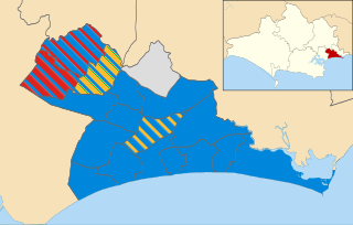
Elections to Bournemouth Borough Council were held on 5 May 2011, in line with other local elections in the United Kingdom. All 54 seats, across 18 wards of this unitary authority, were up for election.

Charminster is a residential and commercial suburb of Bournemouth in Dorset, situated between the suburbs of Springbourne and Winton. It was incorporated into the County Borough of Bournemouth in 1901.

East Cliff is a suburb and ward in Bournemouth, Dorset, England.
Northbourne is a suburb of Bournemouth, Dorset in England. It is in the north of the town and borders Ensbury Park.

Redhill is a northern suburb of Bournemouth, Dorset in England.

Strouden Park is an area of Bournemouth, Dorset, England.
Turbary Park is an area of West Howe, Bournemouth in Dorset. Turbary Park is south of Kinson and north of Wallisdown.

Victoria Park is a area of Bournemouth, Dorset. The area is south of Moordown, north-west of Winton and east of Talbot Village, Wallisdown and Ensbury Park.

Muscliff and Strouden Park is a ward in Bournemouth, Dorset. Since 2019, the ward has elected 3 councillors to Bournemouth, Christchurch and Poole Council.
Coordinates: 50°45′05″N1°49′50″W / 50.75139°N 1.83056°W
| | This Dorset location article is a stub. You can help Wikipedia by expanding it. |