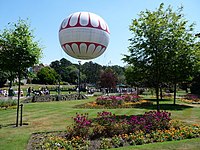
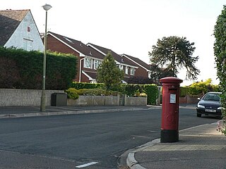
Durley Chine is a Blue Flag beach and chine in Bournemouth, Dorset in England. [1] It is to the west of Bournemouth Town Centre, north of West Cliff, and east of Westbourne. [2]
Durley Chine is a Blue Flag beach and chine in Bournemouth, Dorset in England. [1] It is to the west of Bournemouth Town Centre, north of West Cliff, and east of Westbourne. [2]
On clear days views of the Isle of Wight and Old Harry Rocks can be seen. [3]
Along the beach there are beach huts [4] and a Harvester, known as the Durley Inn. [5]
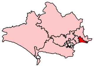
Durley Chine is part of the Bournemouth West parliamentary constituency.

Bournemouth is a coastal resort town on the south coast of England. At the 2011 census, the town had a population of 183,491. With Poole to the west and Christchurch in the east, Bournemouth is part of the South East Dorset conurbation, which has a population of 465,000.

Poole is a large coastal town and seaport in Dorset, on the south coast of England. The town is 21 miles (34 km) east of Dorchester and adjoins Bournemouth to the east. Since 1 April 2019, the local authority is Bournemouth, Christchurch and Poole Council which is a unitary authority. Poole had an estimated population of 151,500 making it the second-largest town in the ceremonial county of Dorset. Together with Bournemouth and Christchurch, the conurbation has a total population of nearly 400,000.
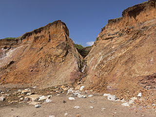
A chine is a steep-sided coastal gorge where a river flows to the sea through, typically, soft eroding cliffs of sandstone or clays. The word is still in use in central Southern England—notably in East Devon, Dorset, Hampshire and the Isle of Wight—to describe such topographical features. The term 'bunny' is sometimes used to describe a chine in Hampshire. The term chine is also used in some Vancouver suburbs in Canada to describe similar features.

Alum Bay is a bay near the westernmost point of the Isle of Wight, England, within close sight of the Needles rock formation. Of geological interest and a tourist attraction, the bay is noted for its multi-coloured sand cliffs. The waters and adjoining seabed form part of the Needles Marine Conservation Zone and the shore and heath above are part of the Headon Warren and West High Down Site of Special Scientific Interest.

Sandbanks is a small peninsula or spit crossing the mouth of Poole Harbour on the English Channel coast at Poole in Dorset, England. It is known for its high property prices and for its award-winning beach. In 2005, Sandbanks was reported to have the fourth highest land value by area in the world. The Sandbanks and Canford Cliffs Coastline area has been dubbed "Britain's Palm Beach".
Bournemouth East is a parliamentary constituency in Dorset represented in the House of Commons of the UK Parliament since 2005 by Tobias Ellwood, a Conservative.

Bournemouth West is a parliamentary constituency represented in the House of Commons of the UK Parliament since 2010 by Conor Burns, a Conservative.

Westbourne is an affluent residential and shopping area of Bournemouth, Dorset. It is located in between Branksome, Poole and the centre of Bournemouth, just off the main A338. Poole Road, mainly full of specialised shops and small cafes, runs through the centre Westbourne with Seamoor Road curving round bringing more shops and services. Many of the shops have residential property above them.

Branksome Park is a suburb of Poole in Dorset, which adjoins Branksome, Dorset. The area covers approximately 360 acres (1.5 km2), mostly occupied by housing, and includes Branksome Chine which leads to the award-winning blue-flagged beaches of Poole.
Bournemouth is a former United Kingdom Parliamentary constituency. The seat was created in 1918 and existed until it was abolished and split into two new seats in 1950. During the constituency's existence it was the most south-westerly seat in Hampshire.
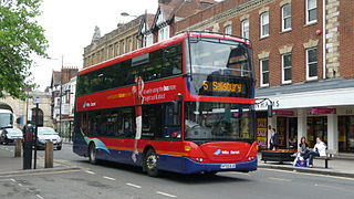
Wilts & Dorset is a bus operator providing services in East Dorset, South Wiltshire, and West Hampshire. It operates services under the morebus brand around Bournemouth and Poole and under the Salisbury Reds brand around Salisbury and Amesbury. It is part of Go South Coast, a subsidiary of the Go-Ahead Group.

Boscombe Surf Reef was an artificial reef built to enhance surfing conditions at Boscombe in Dorset, England.

East Cliff is a suburb and ward in Bournemouth, Dorset, England.

West Cliff is a suburb of Bournemouth, Dorset, England. West Cliff is south of Westbourne and east of Branksome in Poole.

Townsend is a area of Bournemouth, Dorset. It is located in the suburbs along the north eastern boundary of the town and is close to the Royal Bournemouth Hospital.
Northbourne is a suburb of Bournemouth, Dorset in England. It is in the north of the town and borders Ensbury Park.

Redhill is a northern suburb of Bournemouth, Dorset in England.

Strouden Park is an area of Bournemouth, Dorset, England.
Turbary Park is an area of West Howe, Bournemouth in Dorset. Turbary Park is south of Kinson and north of Wallisdown.

Victoria Park is a area of Bournemouth, Dorset. The area is south of Moordown, north-west of Winton and east of Talbot Village, Wallisdown and Ensbury Park.
Coordinates: 50°42′48″N1°53′21″W / 50.71333°N 1.88917°W
| | This Dorset location article is a stub. You can help Wikipedia by expanding it. |