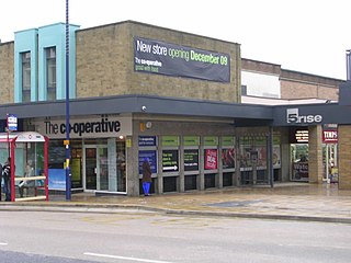
Bingley is a market town and civil parish in the metropolitan borough of the City of Bradford, West Yorkshire, England, on the River Aire and the Leeds and Liverpool Canal, which had a population of 18,294 at the 2011 Census.

Airedale is a valley, or dale, in North Yorkshire and West Yorkshire, England. It is named after the River Aire, which flows through it. The upper valley, from Malham Cove to Airton, is known as Malhamdale, named after the village of Malham. At Airton the valley widens and becomes Airedale proper. The river flows past Skipton on to Keighley, Bingley, Shipley, and Leeds.

The West Riding of Yorkshire was one of three historic subdivisions of Yorkshire, England. From 1889 to 1974 the riding was an administrative county named County of York, West Riding. The lieutenancy at that time included the city of York and as such was named "West Riding of the County of York and the County of the City of York". The riding ceased to be used for administrative purposes in 1974, when England's local government was reformed.
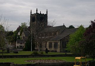
Church of All Saints is the Anglican parish church in the town of Bingley, West Yorkshire, England. It is one of two Anglican churches in the town, the other being Holy Trinity. All Saints has existed since Norman times and it is set in the oldest part of the town, near to where the River Aire is crossed by Ireland Bridge.
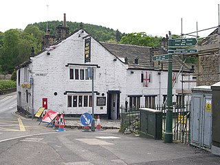
The Old White Horse Inn in Bingley, West Yorkshire, England, is one of the oldest buildings still in use in the town. It was originally constructed as a coaching inn in the mid-seventeenth century, strategically positioned with Ireland Bridge on the one side and the Parish church on the other. The building is an English Grade II listed building and has a significant amount of coaching inn infrastructure surviving including a stable, barn and two coach entrances which are located around an inner courtyard. On each side of the gable are stone lanterns that denote the former owners Order of Knights of St John of Jerusalem. There is evidence that a hostelry has been on the site since 1379.

Bingley's Ireland Bridge is a Grade II* listed structure and a historically significant crossing point over the River Aire in West Yorkshire, England. It is now the main route between Bingley & the nearby villages of Harden, Wilsden & Cullingworth.

Bingley Three Rise Locks is a staircase of three locks on the Leeds and Liverpool Canal at Bingley, West Yorkshire, England. The locks are a Grade II* listed building.

Skidby is a small village and civil parish in Yorkshire Wolds of the East Riding of Yorkshire, England. It is situated about 6 miles (10 km) north-west of Hull city centre, 2.2 miles (3.5 km) west of Cottingham and 5 miles (8 km) south of Beverley.
Cottingley is a suburban village within the City of Bradford district in West Yorkshire, England between Shipley and Bingley. It is known for the Cottingley Fairies, which appeared in a series of photographs taken there during the early 20th century.

Barbon Beck is a small river in Barbondale, Cumbria. It is a tributary of the River Lune.

Beckfoot School is a coeducational secondary school and sixth form with academy status, in Bingley, West Yorkshire, England.

Gilstead is a village within the City of Bradford Metropolitan District, West Yorkshire, England. It is situated at the edge of the moors, above the town of Bingley which is the post town.

Skirden Beck is a minor river in Lancashire, England. It is approximately 4.3 miles (6.85 km) long and has a catchment area of 18.87 square miles (48.882 km2).
Eldwick is a small village near Bingley in the City of Bradford district in West Yorkshire. It is split up into two main parts, Eldwick, the main populated part, and High Eldwick, the larger but less populated section, situated on Bingley Moor.

The Nidd Aqueduct is an aqueduct or man-made watercourse in North Yorkshire, England. It feeds water from Angram and Scar House reservoirs in upper Nidderdale, North Yorkshire 32 mi (51 km) to Bradford in West Yorkshire. The aqueduct supplies 21,000,000 imp gal (95,000 m3) of water per day to Chellow Heights water treatment works. The aqueduct and the reservoirs it connects to are all maintained by Yorkshire Water.

Harden Beck is a stream that flows from Hewenden Reservoir, over Goit Stock Waterfall to the River Aire in Bingley, West Yorkshire. The route starts out further up the valley as Denholme Beck, Hewenden Beck and Hallas Beck. Its waters are fed by Thornton Moor Reservoir, Stubden Reservoir, Doe Park Reservoir and Hewenden Reservoir.

Holy Trinity Church is an Anglican parish church in the town of Bingley, West Yorkshire, England notable for its original church being demolished by explosive charge on 7 April 1974.
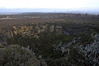
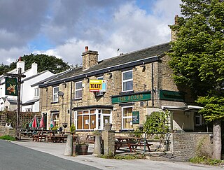
Harden Moor is an expanse of moorland that lies north of the village of Harden in West Yorkshire, England. The moor encompasses stretches of heather, woodland and former quarry workings and is bordered by Airedale to the east, the Worth Valley to the north and Catstones Moor and the village of Cullingworth to the west. Historically, Harden Moor occupied the high ground between Bingley, Keighley, Cullingworth and Harden. Altar Lane, an unmade road which runs from the Brown Cow Inn in Bingley to Keighley Road on Harden Moor is an unofficial border between the estate of St Ives and Harden Moor, but when the St Ives Estate was created, a large swathe of Harden Moor was taken over.
Bingley is a civil parish in the metropolitan borough of the City of Bradford, West Yorkshire, England. It contains 102 listed buildings that are recorded in the National Heritage List for England. Of these, one is listed at Grade I, the highest of the three grades, six are at Grade II*, the middle grade, and the others are at Grade II, the lowest grade. The parish contains the town of Bingley and the surrounding countryside to the north, east and south, including the villages and settlements of Cottingley, Eldwick, Gilstead, and Micklethwaite.

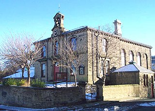
Cottingley Town Hall is a municipal building in Main Street in Cottingley, West Yorkshire, England. The building, which was used as a church and a community centre, is a Grade II listed building.
