Wrose

Last updated

Five Lane Ends - geograph.org.uk - 24283.jpg
Five Lane Ends
West Yorkshire UK location map.svg
Red pog.svg
Wrose
Location within West Yorkshire
Population7,518 (2011 census)
Metropolitan borough
Metropolitan county
Region
Country England
Sovereign state United Kingdom
Post town SHIPLEY
Postcode district BD18
Dialling code 01274
Police West Yorkshire
Fire West Yorkshire
Ambulance Yorkshire
List of places
UK
England
Yorkshire
53°49′40″N1°45′07″W / 53.82791°N 1.75206°W / 53.82791; -1.75206

Wrose is a village and civil parish in the City of Bradford metropolitan borough of West Yorkshire, England, about three miles north of Bradford city centre, and southeast of Shipley. Wrose is in the Windhill and Wrose ward. The civil parish population taken at the 2011 Census was 7,518. [1]

Contents

History

Although the name Wrose was established as a place name within the Manor of Idle by the time of Elizabeth I of England, it is not mentioned in the Poll Tax returns of 1379. [2] The name probably existed as a place name for some time before then.

Rapid house expansion took place in Wrose in the 1930s. Many houses dating from the time of Charles II were demolished to make way for these new semi-detached properties. [2]

Close to the old quarries to the north west of Wrose was the former Wrose Hill brickworks created for the manufacture of bricks and sanitary tubes. [3]

Geography

Wrose sits on top of a hillside at a height of around 600-foot (180 m) above sea level, overlooking the Aire valley and Bradford valley. Wrose is surrounded by other areas of Shipley and Bradford such as Windhill, Woodend, West Royd, Idle Moor, Gaisby and Owlet. [4]

Around the hillside (Carr Hill) can be found the remains of many stone quarries, whose growth exploded in the 19th century as the city of Bradford grew with the wool trade. Many of Bradford's fine Yorkshire millstone buildings are built from these resources. A quarry at nearby Bolton Woods still operates today. The geology of the area is that of mudstones, siltstones, fine sandstones, coal, pipeclay, fireclay and ganister as indicated by exposed rocks in the old quarryparts of which are in a dangerous state. [3]

Governance

Wrose has been a civil parish since 2004 [5] and is entirely surrounded by unparished areas of the City of Bradford.

Landmarks

Churches in Wrose include St Cuthbert's Church, [6] Bolton Villas United Reform Church on Wrose Road and Wrose Chapel on Low Ash Avenue. The local post office is on Wrose Road. [7] Also on Wrose Road are Wrose's two public houses, The Bold Privateer and Wrose Bull. [8] The Bold Privateer is named after the Earl of Cumberland who owned all the land in the Wrose area in the time of Elizabeth I of England. [2] The present-day Wrose Bull was originally named The Hare and Hounds after its move to new premises, but at the insistence of locals was renamed for the colloquial name of the original alehouse. [2] There are listed buildings in Wrose on Snowden Road [9] and Tudor Barn Court. [10]

Economy

Wrose is a largely residential area and there are a number of shops along Wrose Road in Wrose.

Education

Low Ash Primary School is to be found on Wrose Road close to the centre of Wrose. [11]

Transport

Wrose is served by a number of West Yorkshire Transport's bus services. [12]

Notable residents

Wrose was home to the Yorkshire sporting family the Jowets, of which the last and most notable member was Dawson Jowet, founder of the Airedale beagles hunting pack in 1891, and its Master until his death in 1933. [13] His monument remains on Ilkley Moor. Adrian Edmondson comic actor, writer, musician and director, was born in Wrose but grew up in nearby Idle. [14] The former Yorkshire & Humber MEP Richard Corbett, Leader of the Labour MEPs, lives in Wrose.[ citation needed ]

See also

Related Research Articles

<span class="mw-page-title-main">Esholt</span> Village in West Yorkshire, England

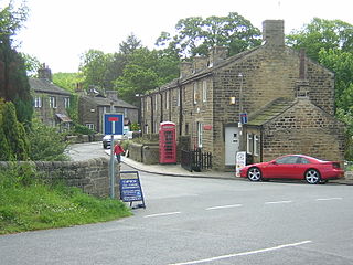
Esholt is a village between Shipley and Guiseley, in the metropolitan district of the City of Bradford, West Yorkshire, England. It is situated 3 miles (4.8 km) east of Shipley town centre, 1.5 miles (2.4 km) south-west of the A65 in Guiseley, 7 miles (11 km) north of Bradford City Centre, and 10 miles (16 km) north-west of Millennium Square, Leeds.

<span class="mw-page-title-main">Shipley, West Yorkshire</span> Town and civil parish in West Yorkshire, England

Shipley is a historic market town and civil parish in the City of Bradford, West Yorkshire, England, by the River Aire and the Leeds and Liverpool Canal, north of Bradford. The population of the Shipley ward on Bradford City Council taken at the 2011 Census was 15,483.

<span class="mw-page-title-main">Airedale</span>

Airedale is a geographic area in Yorkshire, England, corresponding to the river valley or dale of the River Aire.

<span class="mw-page-title-main">City of Bradford</span> City and metropolitan borough in West Yorkshire, England

The City of Bradford is a local government district of West Yorkshire, England, with the status of a city and metropolitan borough. It is named after its largest settlement, Bradford, but covers a large area which includes the towns and villages of Keighley, Shipley, Bingley, Ilkley, Haworth, Silsden, Queensbury, Thornton and Denholme. Bradford has a population of 528,155, making it the fourth-most populous metropolitan district and the sixth-most populous local authority district in England. It forms part of the West Yorkshire Urban Area conurbation which in 2011 had a population of 1,777,934, and the city is part of the Leeds-Bradford Larger Urban Zone (LUZ), which, with a population of 2,393,300, is the fourth largest in the United Kingdom after London, Birmingham and Manchester.

<span class="mw-page-title-main">Horsforth</span> Town and civil parish in West Yorkshire, England

Horsforth is a town and civil parish in the City of Leeds, West Yorkshire, England, five miles north-west of Leeds city centre. Historically a village within the West Riding of Yorkshire, it had a population of 18,895 at the 2011 Census. It became part of the City of Leeds metropolitan borough in 1974. In 1999, a civil parish was created for the area, and the parish council voted to rename itself a town council. The area is within the Horsforth ward of Leeds City Council, which also includes the southern part of Rawdon.

Kildwick, or Kildwick-in-Craven, is a village and civil parish of the district of Craven in North Yorkshire, England. It is situated between Skipton and Keighley and had a population of 191 in 2001, rising slightly to 194 at the 2011 census. Kildwick is a landmark as where the major road from Keighley to Skipton crosses the River Aire. The village's amenities include a primary school, church and public house.

<span class="mw-page-title-main">Eccleshill, Bradford</span> Area of Bradford, West Yorkshire, England

Eccleshill is an area, former village, and ward within the City of Bradford Metropolitan District Council in the county of West Yorkshire, England. The ward population of Eccleshill is 17,540, increasing at the 2011 Census to 17,945. Eccleshill is a more or less completely residential urban area with very little open space although there is substantial open land directly to the east.

<span class="mw-page-title-main">Shipley railway station</span> Railway station in West Yorkshire, England

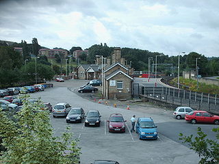
Shipley railway station serves the market town of Shipley in West Yorkshire, England. It is 2+34 miles (4.4 km) north of Bradford Forster Square and 10+34 miles (17.3 km) northwest of Leeds.

<span class="mw-page-title-main">Windhill and Wrose</span> Human settlement in the United Kingdom

Windhill and Wrose is a ward within the City of Bradford Metropolitan District Council in the county of West Yorkshire, England, named after the districts of Windhill and Wrose around which it is drawn.

<span class="mw-page-title-main">Shipley and Windhill railway station</span> Disused railway station in West Yorkshire, England

Shipley and Windhill railway station was a railway station in Shipley, West Yorkshire, England between 1875 and 1931.

<span class="mw-page-title-main">Idle railway station (Leeds and Bradford Railway)</span> Disused railway station in West Yorkshire, England

Idle railway station was a short-lived station serving Idle, near Bradford, West Yorkshire, England.

<span class="mw-page-title-main">Idle, West Yorkshire</span> Area of Bradford in west Yorkshire, England

Idle is a residential suburban area in the city of Bradford, West Yorkshire, in England and was a separate village, and before that it was the Manor of Idle. Idle is loosely bordered by the areas of Eccleshill, Wrose, Thackley, Apperley Bridge, and Greengates, in the north-east of the city.

<span class="mw-page-title-main">Thackley</span> Village in West Yorkshire, England

Thackley is a small suburb near Bradford, West Yorkshire in England. The village is loosely bordered by the village of Idle to the south, to the west by the West Royd area of Shipley and elsewhere by the Leeds and Liverpool Canal. Thackley is the northernmost part of Bradford south of the River Aire.

<span class="mw-page-title-main">Steeton, West Yorkshire</span> Village in West Yorkshire, England

Steeton is a village in the City of Bradford metropolitan borough, West Yorkshire, England. Historically part of the West Riding of Yorkshire, it is situated approximately 5 miles (8 km) south-east from Skipton, 3 miles (5 km) north-west from Keighley and just south of the A629 road. The village is part of Steeton with Eastburn civil parish.

<span class="mw-page-title-main">Shipley Great Northern Railway branch line</span> Disused railway line in West Yorkshire, England

The Shipley Great Northern Railway branch line was a railway line that ran east, south and then westwards from Shipley to Bradford in West Yorkshire. The route was opened in 1874 to goods traffic and then to passengers in 1875 by the Great Northern Railway (GNR) and looped around the eastern edge of Bradford. The GNR arrived after other railways had been established in the West Yorkshire area and many of their lines were heavily reliant on tunnels and grand viaducts, the Shipley and Windhill line being an exception to this, although it did have some steep gradients. The branch extended for 8.5 miles (13.7 km) between the two termini of Shipley Windhill and Bradford Exchange. The route as built from Laisterdyke to Shipley was actually only 6.5 miles (10.5 km) as the initial section from Bradford Exchange to Laisterdyke was already in existence as part of the Great Northern Railway's line to Leeds.

<span class="mw-page-title-main">Bradford Dale (Yorkshire)</span> Valley in West Yorkshire, England

Bradford Dale, is a side valley of Airedale that feeds water from Bradford Beck across the City of Bradford into the River Aire at Shipley in West Yorkshire, England. Whilst it is in Yorkshire and a dale, it is not part of the Yorkshire Dales and has more in common with Lower Nidderdale and Lower Airedale for its industrialisation.

Windhill and Wrose is a ward, and Wrose is a civil parish, both in the metropolitan borough of the City of Bradford, West Yorkshire, England. The ward and parish contain ten listed buildings that are recorded in the National Heritage List for England. Of these, two are listed at Grade II*, the middle of the three grades, and the others are at Grade II, the lowest grade. The listed buildings consist of houses and cottages, a school later used for other purposes, and a public house.

<span class="mw-page-title-main">Shipley Town Hall</span> Municipal building in Shipley, West Yorkshire, England

Shipley Town Hall is a municipal structure in Kirkgate in Shipley, West Yorkshire, England. It was the headquarters of Shipley Urban District Council.

References

  1. UK Census (2011). "Local Area Report – Wrose Parish (E04000169)". Nomis. Office for National Statistics . Retrieved 30 July 2023.
  2. 1 2 3 4 Humphreys, Martin (2017). "A short history of Wrose". Wrose Parish Council. Archived from the original on 7 January 2016. Retrieved 23 August 2017.
  3. 1 2 "Wrose Hill, Shipley" (PDF). West Yorkshire Geology Trust. Retrieved 23 July 2012.
  4. Leeds and Bradford A-Z (2 ed.). Geographers A-Z Map Co. Ltd. 2006. ISBN   1-84348-209-6.
  5. "Nine elected to new parish council". Bradford Telegraph and Argus. 16 June 2004. Retrieved 4 December 2011.
  6. "St Cuthbert's Church". St Cuthbert's Church. Retrieved 3 July 2018.
  7. "Wrose Post Office Opening Times". Post Office Opening Hours. Archived from the original on 18 October 2013. Retrieved 3 November 2013.
  8. "Pubs in Wrose". Pubs Galore. Retrieved 19 October 2012.
  9. "3 and 5, Snowden Road, Wrose". British Listed Buildings. Retrieved 19 October 2012.; "33 and 35, Snowden Road, Wrose". British Listed Buildings. Retrieved 19 October 2012.
  10. "24 and 26, Towngate, Wrose". British Listed Buildings. Retrieved 19 October 2012.
  11. "Low Ash Primary School". Low Ash Primary School. Retrieved 3 November 2013.
  12. "Bus timetables: Services 800 to 967". West Yorkshire Metro. Retrieved 23 July 2012.
  13. "History of the Airedale Beagles". Airedale Beagles. Retrieved 3 December 2011.
  14. "The Shared Heritage Trail of Immanuel College, Idle, Thackley, Blakehill and Thorpe Primary Schools". Blakehill Primary School. Retrieved 22 November 2015.[ dead link ]