Shipley, West Yorkshire

Last updated

Shipley
Shipley town centre.jpg
Shipley town centre (June 2010)
West Yorkshire UK location map.svg
Red pog.svg
Shipley
Location within West Yorkshire
Population15,483 (ward. 2011)
OS grid reference SE 146 375
Civil parish
  • Shipley
Metropolitan borough
Metropolitan county
Region
Country England
Sovereign state United Kingdom
Post town Shipley
Postcode district BD17-18
Dialling code 01274
Police West Yorkshire
Fire West Yorkshire
Ambulance Yorkshire
UK Parliament
Councillors
List of places
UK
England
Yorkshire
53°49′59″N1°46′37″W / 53.833°N 1.777°W / 53.833; -1.777

Shipley is a historic market town and civil parish [1] in the City of Bradford, West Yorkshire, England.

Contents

Located on the River Aire and the Leeds and Liverpool Canal, Shipley is directly north of the city of Bradford. The population of Shipley at the 2011 Census was 15,483. [2]

Until 1974, Shipley was an urban district in the West Riding of Yorkshire. The town forms a continuous urban area with Bradford.

History

Toponymy

The place-name Shipley derives from two words: the Old English scīp ('sheep', a Northumbrian dialect form, contrasting with the Anglian dialect form scēp which underlies modern English sheep) [3] and lēah meaning either 'a forest, wood, glade, clearing' or, later, 'a pasture, meadow'. [4] It has therefore been variously defined as 'forest clearing used for sheep' [5] or 'sheep field'. [6]

Early history

Shipley appears to have first been settled in the late Bronze Age [5] and is mentioned in the Domesday Book of 1086, in the form Scipelei(a). [3]

Its early history relies on the records of a succession of Lords of the Manor, not all of whom were in permanent residence. The rolls of the manor court have been missing since the 18th century, [7] leaving the records incomplete. In the 12th century, 'Adam, son of Peter', an early Lord of the Manor, granted grazing and iron ore mining rights to the monks of Rievaulx Abbey. [7] Through the Middle Ages the Lords were the 'Earls of Ormande' (sic), possibly the Irish Earls of Ormond, followed by the Gascoigne family. In 1495, Rosamund Gascoigne, a daughter of one of the William Gascoignes who held the title, married Robert Rawson, thought to be related to the Rawson family of Bradford, after whom one of the city's markets is named. Their son, William, married a cousin, Agnes Gascoigne, and through the marriage the Rawson family inherited the manor in 1570. [8]

The Rawsons lived at Over Hall known as the Manor House, on the site of the current town hall. The manor estates extended to Northcliff. [9] The family had interests in Halifax and moved there in the early 18th century, retaining their Shipley estates until the last male heir died in 1745. [10]

By the 19th century the Rawson estates and those of the Fields, another prominent land-owning family, had become the property of the Earl of Rosse [11] who had extensive holdings in Heaton. His legacy has endured in the name of a public house on the main Bradford to Keighley road, and Rossefield School in Heaton. Of the lower orders at this time not much is known, but there was relief housing offered at the town's expense near Crowghyll. [12]

Industrial Revolution

Canal-side mills, Shipley Canal side, Shipley - geograph.org.uk - 347005.jpg
Canal-side mills, Shipley

Shipley was shaped largely by the Industrial Revolution and, in particular, the growth of the textile industry. Textile manufacture dates from pre-industrial times. As the place name indicates, Shipley had a history as sheep grazing land, so wool was plentiful, and the River Aire was a ready source of water for powering water mills and cleaning processes. There was a fulling mill in Shipley by 1500 and two more by 1559. [13] Another mill was built by the Dixon family on the banks of the Aire in 1635. New Mill on the far side of Hirst Wood was built in the 1740s and by the late 18th century between 9,000 and 10,000 pieces of broadcloth were being fulled annually at Shipley's mills. [14] Much work was undertaken in workers' cottages which had 'loom shops' for spinning yarn. Home workshops were once a common sight along the River Aire and often had external flights of steps. Examples can be seen in the cottages at Jane Hills along the canal in Saltaire. [15]

The industrial era ended cottage industry. Providence Mill, one of the first steam-driven mills was built for Denby Bros. in 1796. [16] Other spinning mills followed, including Ashley Mill, Prospect Mill, Red Beck Mill on Heaton Beck (c. 1815), Well Croft Mill (c. 1840s) and Whiting Mill on Briggate. [17]

The smaller mills gave way to larger premises which could combine all the processes of worsted production on one site. The first was Joseph Hargreaves' Airedale Mills (demolished 1970s), Salts Mill (built 1853 and now a gallery and restaurant complex), an enlarged Well Croft Mill (demolished 1950s) and Victoria Mills near the canal... [18] Hargreaves employed 1,250, Salt initially 2,500 and by 1876 total employment in the mills was 6,900. [18]

The growth in textile production stimulated the growth of associated supply industries. Other local employers included loom makers, Lee and Crabtree, WP Butterfield's galvanised containers and J. Parkinson and Sons machine tool makers. [19]

The other major effect of industrialisation was the vast expansion in housing stock. Titus Salt's Saltaire is an example of a model village, and Hargreaves had cottages built for his workers around the town centre and his mill. He built 92 back-to-back houses along Market Street and Central Avenue in an area which came to be called Hargreaves Square or The Square. The houses were built by filling in the old courtyards. [20] The population of the township grew from 1,214 in 1822 [21] to just over 3,000 in 1851 to 10,000 by 1869. [22]

It was then the landowning families—the Rosses, the Crompton-Stansfields and the Wainmans—took advantage of the demand for housing by selling their less productive land on Low Moor and High Moor. Houses for the better off were built in Sunny Bank and Hall Royd in the 1840s, 1850s and 1860s. [23] Kirkgate was lined with villas from the 1860s, some of which still stand. Middle-class houses were built in the Nab Wood and Moorhead districts. In 1870 a tranche of land in Moorhead was sold by the Countess of Rosse to build five streets of terraces. The public house on Saltaire Roundabout that bears her name dates from that time. [24]

Post-war redevelopment

Shipley Market Place (August 2009) Shipley Market Place.jpg
Shipley Market Place (August 2009)

The decline of the textile industry saw the demolition of many mills, only Salts Mill and Victoria Mills remain and have been converted to other uses.

Of more concern in the immediate post-war period was the deteriorating housing stock. In the 1950s, the back-to-backs of Hargreaves' Square were condemned as slums and the site redeveloped. The redevelopment removed several historic buildings – Shipley Old Hall (1593), at the junction of Kirkgate and Manor Lane [25] and of which a few fragments of roof drainage and a roof truss survive in Crowghyll Park, [26] Shipley Hall (1734), which stood at the junction of Market Street and Otley Road became the headquarters of Windhill Cooperative Society [25] and possibly Hudson Fold House (1629). [27] Of the major Victorian town centre buildings, only the Old Bradford Bank (now Barclays) and Sun Hotel remain. [28] The slums were replaced with low-rise modern retail outlets, a central square serves as an outdoor market and an underground indoor market is situated beneath a tall, brutalist market hall tower which is a visible landmark for many miles around. Until recently the tower had a 'man' striking a bell to mark the hours. [29]

A second phase of clearance in 1978 saw the construction of a library, swimming pool and health centre, with Asda added in 1985. Croft House (1729), a stone built farmhouse which was converted to a school and then subsequently used as the Labour Party headquarters was a casualty of this development. By 1970 2,900 slum houses had been demolished. [30]

The Otley and Leeds Roads were widened in the early 1970s, at the expense of the Fox and Hounds Hotel after which Shipley's main road junction, Fox Corner, was named. [16]

Geography

Shipley is located at an important crossing of the River Aire, where the route from Otley to Bradford crosses the route from Skipton to Leeds. It is sheltered by the millstone crags of Wrose and Windhill to the east, and to the north by Baildon and Hawksworth Moors. [31]

Early development in Shipley was centred on the crossroads, locally known today as Fox Corner after the former Fox and Hounds pub that stood there. [32] [33] [ page needed ] Here, as today, the route from Otley to Bradford crossed the route from Skipton to Leeds at an important crossing of the River Aire. [33] [ page needed ] The present Kirkgate and Manor Lane (then known as Sower Lane) were probably no more than tracks. [7]

In medieval times, Shipley consisted of the settlement around the crossroads, and the unenclosed fields at Shipley Fields and the Hirst which were collectively farmed. Beyond these lay the Low Moor, which ran from the Crowghyll to the former Saltaire roundabout (now a junction on the Bradford to Keighley road), in the approximate area of modern day Wycliffe, [31] and the wasteland of High Moor (from Saltaire roundabout, through Moorhead, as far as New Brighton and Noon Nick). [31] These areas were steep, rocky land, unsuitable for farming. [34] By 1600 at the latest, the open fields had been enclosed and given way to individual farms. [35] The town was bounded to the north by the River Aire, to the east by Bradford Beck, with Cottingley and Heaton lying beyond its western and southern boundaries. [7]

Outlying districts, such as Windhill, were not part of Shipley until the 19th century. Saltaire became part of Shipley after its foundation in the 1860s, while Windhill, which had previously been part of Idle, became part of the Shipley Urban District in 1894. [11]

Governance

Shipley Town Hall Shipley Town Hall (16381850951).jpg
Shipley Town Hall

Shipley was historically a township and chapelry in the large ancient parish of Bradford. [36] Shipley Local Board was formed in 1853. Originally the board met at the Sun Hotel near the market. In 1880, it moved to the old Manor House, until it was demolished in 1915. Shipley became a separate civil parish in 1866. In 1894, Shipley Urban District Council was constituted with 15 councillors, [37] and Shipley incorporated the Windhill district, formerly part of Idle. An attempt was made to gain borough status in 1898, but failed. [38] Shipley Town Hall was built in 1932, as part of a scheme to relieve high unemployment during the Great Depression and was opened by the Earl of Harewood. [25] It became the seat of Shipley's administration for the next four decades.

For many years, Shipley opposed joining Bradford for local government purposes whenever it was proposed. A large protest march marked the third attempt in 1937. [39] In 1974 after local government reorganisation, merger into Bradford seemed inevitable, and no resistance was offered. [40]

The Shipley parliamentary constituency was created in 1885, and its first MP was Joseph Craven.

A campaign for Shipley to have a Town Council was launched in 2018, [41] resulting in the creation of Shipley Town Council in January 2020. [42]

Councillors

Shipley electoral ward is represented on Bradford Metropolitan District Council by three councillors; Anna Watson (Green Party), [43] Kevin Warnes (Green Party), [44] and Martin Love (Green Party) [45]

2004 Boundaries of Shipley Ward. Shipley Ward 2004.png
2004 Boundaries of Shipley Ward.
ElectionCouncillorCouncillorCouncillor
2004 Hawarun Hussain (Green)Kevin Warnes (Green)Martin Love (Green)
2006 Hawarun Hussain (Green)Kevin Warnes (Green)Martin Love (Green)
2007 Hawarun Hussain (Green)Kevin Warnes (Green)Martin Love (Green)
2008 Hawarun Hussain (Green)Kevin Warnes (Green)Martin Love (Green)
2010 Hawarun Hussain (Green)Kevin Warnes (Green)Martin Love (Green)
2011 Hawarun Hussain (Green)Kevin Warnes (Green)Martin Love (Green)
2012 Hawarun Hussain (Green)Kevin Warnes (Green)Martin Love (Green)
2014 Hawarun Hussain (Green)Kevin Warnes (Green)Martin Love (Green)
2015 Hawarun Hussain (Green)Kevin Warnes (Green)Martin Love (Green)
2016 Hawarun Hussain (Green)Kevin Warnes (Green)Martin Love (Green)
2018 Vick Jenkins (Labour)Kevin Warnes (Green)Martin Love (Green)
2019 Vick Jenkins (Labour)Kevin Warnes (Green)Martin Love (Green)
2021 Vick Jenkins (Independent)Kevin Warnes (Green)Martin Love (Green)
2022 Anna Watson (Green)Kevin Warnes (Green)Martin Love (Green)

  indicates seat up for re-election.

The four wards of Shipley Town Council are represented by nine councillors with two vacancies which will be filled by September 2020. [46]

WardCouncillor
Saltaire and HirstwoodMike Connors (Chair)
Darren Parkinson
James Roberts
Nabwood and MoorheadVacant
Ros Garside
Shipley Central & DocksideDarren Longhorn
Northcliffe and NorwoodsDave Robison
Jenna Spiers
Anna Watson

Economy

Commercial and retail

Shipley market hall Shipley Market, rear1.jpg
Shipley market hall

Shipley is dominantly residential in character serving as a commuter suburb of larger urban employment centres in Bradford and Leeds. Manufacturing activity includes information technology specialist ARRIS located in the Salts Mill complex. Marlin Windows, HC Slingsby and the offices of the Bradford Health Authority also feature among the larger employers in the town.

The town has one large scale supermarket, Asda in the town centre, but also supports smaller scale supermarkets and convenience shops. An open air market is a feature of the main commercial centre of the town as well as a covered market hall known for its landmark clock tower and 1960s brutalist architecture. Other shops in the same precinct include an Arndale Centre, retailers such as Boots. A pedestrian precinct with some shops and leisure businesses links Asda and its multi-storey free car park with Market Square. This area also includes the Shipley Library and the Kirkgate Centre, the town's main cultural focus offering regular a range of community activities in addition to holding cultural events such as live music, a regular alternative market and world cinema.

The town's secondary commercial centre, Gordon Terrace, part of the historic Saltaire Village development, features independent food and fashion retailers, as well as numerous restaurants and cafes. The town has a large volume of through vehicle traffic as it is on two of the main routes between Bradford, Leeds and the Aire Valley towns of Bingley, Keighley, and Skipton.

Visitor attractions

Salts Mill alongside the Leeds and Liverpool Canal Saltaire from Leeds and Liverpool Canal.jpg
Salts Mill alongside the Leeds and Liverpool Canal

The village of Saltaire located in Shipley is a UNESCO designated World Heritage Site incorporating the Victorian era Salts Mill and associated residential district. Located by the River Aire and Leeds and Liverpool Canal the model village was planned by industrialist Sir Titus Salt as a processing facility for alpaca woollen cloth and as residential accommodation for his workforce. Salts Mill is no longer used for textile production, but now contains the 1853 Gallery, housing many works by the artist David Hockney, a variety of shops, restaurants and local businesses, including Pace Micro Technology (now Arris). Salts Mill is accessed via the nearby Saltaire railway station and together with the stone built terraced houses, ornate Victorian era civic buildings and Roberts Park, draws significant numbers of tourists to the area.

To the north across the River Aire, is Shipley Glen ("glen" refers to the little valley beneath a ridge). It has long been a popular beauty spot, and in 1895 the Shipley Glen Tramway was built to carry visitors up to the top. The tramway has weathered periods of neglect and closure, but in 2012 it ran most weekends through the summer, staffed by volunteers.

Looking over Shipley from Northcliffe Overview of Shipley, West Yorkshire.jpg
Looking over Shipley from Northcliffe

Parks and gardens

Crowghyll Park was once a quarry and the town's refuse dump. [47] The land was given to church wardens in lieu of common rights when Shipley Common was enclosed and in 1889 it was landscaped. A public playground was opened by Mrs Titus Salt in 1890. [48] A larger recreation area with playing fields, allotments, woods, and a private golf club is situated on the hill at Northcliffe. The woods and playing fields were opened to the public by Norman Rae MP and the playing fields are named after him. [49] In the village of Saltaire is Roberts Park, built by Sir Titus Salt for his workers' recreation.

Theatre and cinema

The Victoria Hall in Saltaire is a concert venue, hosting bands such as Fairport Convention. However, there were once a number of entertainment establishments within the district:

Shipley Film Society was established in 2010 to bring cinema back to Shipley, and runs a programme of independent and world cinema between September and May each year.

Libraries

The library on Well Croft in the town centre is a branch library of Bradford Central Library. A Carnegie Library on Briggate built with a £3,000 donation by Andrew Carnegie now stands empty [57] but the name persists in Carnegie Drive and the Carnegie Clinic.

Industry

Shipley used to house the Naylor Cars, Ltd., that produced the Naylor TF 1700, an MG TF replica. Industrial businesses with a presence in Shipley include Denso Marsten, Manor Coatings, Produmax, Teledyne and HC Slingsby.

Religion

Traditionally, non-conformist churches have predominated in Shipley and this is still the case to some extent today. There are four Methodist churches, which feature Victorian architecture. These are: Northcliffe on the site of a 'tin chapel', [56] Crag Road, Saltaire and Christ Church at Windhill. [58] Saltaire United Reformed Church was built in the Italianate style at the behest of Sir Titus Salt in 1859. It is a Grade I listed building. [59]

St Paul's, Shipley St Pauls, Shipley, West Yorkshire.jpg
St Paul's, Shipley

The first place of worship in Shipley was the Bethel Baptist Chapel in 1758, it was rebuilt in 1836 and demolished in the early 1970s and only part of the graveyard survives. [60] A second Baptist chapel was built at Rosse Street near the town centre in 1865 and is still in use. There is a Victorian Salvation Army Citadel on Rhodes Place.

Historically, Shipley was part of the parish of Bradford and did not have a church until well into the 19th century. The first Anglican church was the Gothic St Paul's on Kirkgate, consecrated by Edward Harcourt, Archbishop of York in 1826. [61] It was built at a cost of £7,687.19s.3d, a gift of the nation under the Million Act, [62] on land donated by John Wilmer Field, from the Shipley land-owning family. [60] The parish of Shipley cum Heaton was created on 30 May 1828 by an order in council of King George IV. [62] St Paul's is one of an identical pair of churches with Wilsden Church. [61] A graveyard was added in 1860, but by 1895 was full and additional land at Hirst Wood was consecrated. [61] The church seated 1488 and has an organ built by Binns of Bramley in 1892. [26]

Other Anglican churches in the town are St Margaret's, Frizinghall and St Peter's in Moorhead Lane. The later was commissioned in 1888 as a daughter church for St Paul's and consecrated in 1909 by the Bishop of Ripon. [63] The Roman Catholic Church of St Theresa Benedicta and St Walburga, usually referred to as St Walburga's is situated on Kirkgate. [58]

Transport

Road

The Bradford to Bingley Road was constructed in the 1820s [60] and with Otley Road and Saltaire Road form a triangle framing Shipley centre. They connect the town to Bradford, Leeds and the Airedale towns. In September 2022, a clean air zone was launched in Bradford and Shipley. This means any non-private cars entering the city centre and the Canal Road corridor towards Shipley, will be charged dependent on the size of the vehicle and the commercial reason for entering. Exemptions apply for greener vehicles such as low-emission or electric. [64] [65]

There is a small bus station in Shipley Market Place.

Rail

Platforms 1 and 2 at Shipley railway station Footbridge over Platforms 1 and 2 - Shipley Station - geograph.org.uk - 1586731.jpg
Platforms 1 and 2 at Shipley railway station

The Midland Railway's Leeds and Bradford line opened on 2 July 1846 and was extended to Keighley by March 1847. The Guiseley branch opened on 4 December 1876 and in the same year completion of the Settle-Carlisle Line put Shipley on the London to Scotland route. In 1885, the old Midland Railway station was replaced, and by 1900, 400 trains were passing through Shipley each month, carrying 50,000 passengers. [66]

Shipley railway station has an unusual triangular layout, serving trains on the Skipton to Leeds line, the Leeds to Bradford Forster Square line, and the Bradford to Skipton/Ilkley lines. Saltaire railway station, reopened in 1984 on the Settle-Carlisle Line, serves the heritage village of Saltaire. Long-distance trains run south to London King's Cross and north to Carlisle, while local trains connect the town with Leeds, Bradford and Skipton.

Canals

The Leeds and Liverpool Canal was once an important navigation linking Shipley to the wider world. The Skipton to Shipley section was completed in 1773 and in 1774 a branch was extended to Bradford. Wharves were established on the north side of Briggate. [26] The Bradford branch was filled in during the 1920s. The canal is used for pleasure cruising.

Trams

Trams ran along Bradford Road to the south and Saltaire Road to the north [67] and between Baildon Bridge and the Branch. The intersection of these lines led to the main road junction of Fox's Corner being given the alternative name of Cobweb Square. [28] The legacy of trams is the terminal building on Saltaire Roundabout, now a public house named Salt Bar & Kitchen. There was a second tram shed off the roundabout at the foot of Moorhead Lane.

Saltaire shed was converted for trolleybuses in 1939 until Bradford scrapped trolleybuses in the 1970s.

Newspapers

The town's first newspaper was the Shipley Times & Express run by stationer and printer, Johnny Walker. [32] The paper was based in premises at Shipley crossroads, and the junction was sometimes called Johnny Walker's Corner as well as Fox Corner. In 1922, Walker sold out to printer/stationer, Osbaldiston, and the building still stands under his name. The building is now a scuba diving centre called Duck and Dive. The paper closed in 1981. [68]

Shipley is in the distribution area of the Bradford-based Telegraph & Argus . The Telegraph & Argus produced a free newspaper for the district, the Aire Valley (or Shipley) Target, which was then produced as one of four local editions of the Bradford & District Advertiser . [69] This no longer prints.

The Saltaire Review was launched by Festival Publications in October 2014. It is published bi-monthly and covers community issues and events, with an estimated readership of over 18,000. [70]

Notable people

Notable people from Shipley, England, educated there, or otherwise associated with the town.

Academics

Arts and entertainment

Politicians

Science

Sport

Writers and journalists

See also

Related Research Articles

<span class="mw-page-title-main">Bingley</span> Town in West Yorkshire, England

Bingley is a market town and civil parish in the metropolitan borough of the City of Bradford, West Yorkshire, England, on the River Aire and the Leeds and Liverpool Canal, which had a population of 18,294 at the 2011 Census.

<span class="mw-page-title-main">Saltaire</span> Village in West Yorkshire, England

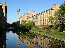
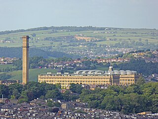
Saltaire is a Victorian model village in Shipley, West Yorkshire, England, situated between the River Aire, the railway, and the Leeds and Liverpool Canal. Salt's Mill and the houses were built by Titus Salt between 1851 and 1871 to allow his workers to live in better conditions than the slums of Bradford. The mill ceased production in 1986, and was converted into a multifunctional location with an art gallery, restaurants, and the headquarters of a technology company. It is a UNESCO World Heritage Site and on the European Route of Industrial Heritage.

<span class="mw-page-title-main">Baildon</span> Town and civil parish in West Yorkshire, England

Baildon is a town and civil parish in the Bradford Metropolitan Borough in West Yorkshire, England and within the historic boundaries of the West Riding of Yorkshire.

<span class="mw-page-title-main">Airedale</span> Valley in North and West Yorkshire, England

Airedale is a valley, or dale, in North Yorkshire and West Yorkshire, England. It is named after the River Aire, which flows through it. The upper valley, from Malham Cove to Airton, is known as Malhamdale, named after the village of Malham. At Airton the valley widens and becomes Airedale proper. The river flows past Skipton on to Keighley, Bingley, Shipley, and Leeds.

<span class="mw-page-title-main">City of Bradford</span> City and metropolitan borough in West Yorkshire, England

Bradford, also called the City of Bradford, is a metropolitan borough in West Yorkshire, England. It is named after its largest settlement, Bradford, but covers a larger area which includes the towns and villages of Keighley, Shipley, Bingley, Ilkley, Haworth, Silsden, Queensbury, Thornton and Denholme. Bradford has a population of 528,155, making it the fourth-most populous metropolitan district and the sixth-most populous local authority district in England. It forms part of the West Yorkshire Urban Area conurbation which in 2011 had a population of 1,777,934, and the city is part of the Leeds-Bradford Larger Urban Zone (LUZ), which, with a population of 2,393,300, is the fourth largest in the United Kingdom after London, Birmingham and Manchester.

<span class="mw-page-title-main">Bradford Canal</span> English canal

The Bradford Canal was a 3.5-mile (5.6 km) English canal which ran from the Leeds and Liverpool Canal at Shipley into the centre of Bradford. It opened in 1774, and was closed in 1866, when it was declared to be a public health hazard. Four years later it reopened with a better water supply, and closed for the second time in 1922. It was subsequently filled in, although consideration has been given to restoring it. There are some remains, including a short section of canal at the junction and a pumping station building, which is now a dwelling.

Kildwick, or Kildwick-in-Craven, is a village and civil parish of the district of Craven in North Yorkshire, England. It is situated between Skipton and Keighley and had a population of 191 in 2001, rising slightly to 194 at the 2011 census. Kildwick is a landmark as where the major road from Keighley to Skipton crosses the River Aire. The village's amenities include a primary school, church and public house.

<span class="mw-page-title-main">Bradford Forster Square railway station</span> Railway station in West Yorkshire, England

Bradford Forster Square railway station serves Bradford, West Yorkshire, England. The majority of services to/from station use Class 333 electric multiple units operated by Northern Trains; they run on the Airedale line to Skipton, the Wharfedale line to Ilkley and the Leeds-Bradford line to Leeds.

<span class="mw-page-title-main">Eccleshill, Bradford</span> Area of Bradford, West Yorkshire, England

Eccleshill is an area, former village, and ward within the City of Bradford Metropolitan District Council in the county of West Yorkshire, England. The ward population of Eccleshill is 17,540, increasing at the 2011 Census to 17,945. Eccleshill is a more or less completely residential urban area with very little open space although there is substantial open land directly to the east.

<span class="mw-page-title-main">Shipley railway station</span> Railway station in West Yorkshire, England

Shipley railway station serves the market town of Shipley in West Yorkshire, England. It is 2+34 miles (4.4 km) north of Bradford Forster Square and 10+34 miles (17.3 km) northwest of Leeds.

<span class="mw-page-title-main">Saltaire railway station</span> Railway station in West Yorkshire, England

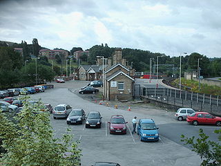
Saltaire railway station serves the Victorian model village of Saltaire near Shipley in West Yorkshire, England. It is situated 3+12 miles (6 km) north of Bradford Forster Square.

<span class="mw-page-title-main">History of Leeds</span> History of city in Yorkshire, England

Loidis, from which Leeds, Yorkshire derives its name, was anciently a forested area of the Celtic kingdom of Elmet. The settlement certainly existed at the time of the Norman conquest of England and in 1086 was a thriving manor under the overlordship of Ilbert de Lacy. It gained its first charter from Maurice de Gant in 1207 yet only grew slowly throughout the medieval and Tudor periods. The town had become part of the Duchy of Lancaster and reverted to the crown in the medieval period, so was a Royalist stronghold at the start of the English Civil War.

<span class="mw-page-title-main">Idle, West Yorkshire</span> Area of Bradford in west Yorkshire, England

Idle is a residential suburban area in the city of Bradford, West Yorkshire, in England and was a separate village, and before that it was the Manor of Idle. Idle is loosely bordered by the areas of Eccleshill, Wrose, Thackley, Apperley Bridge, and Greengates, in the north-east of the city.

<span class="mw-page-title-main">Thackley</span> Village in West Yorkshire, England

Thackley is a small suburb near Bradford, West Yorkshire in England. The village is loosely bordered by the village of Idle to the south, to the west by the West Royd area of Shipley and elsewhere by the Leeds and Liverpool Canal. Thackley is the northernmost part of Bradford south of the River Aire.

<span class="mw-page-title-main">Bradford</span> City in West Yorkshire, England

Bradford is a city in West Yorkshire, England. It became a municipal borough in 1847, received a city charter in 1897 and, since the 1974 reform, the city status has belonged to the larger City of Bradford metropolitan borough. It had a population of 349,561 at the 2011 census; the second-largest subdivision of the West Yorkshire Built-up Area after Leeds, which is approximately 9 miles (14 km) to the east. The borough had a population of 546,976, making it the 9th most populous district in England.

<span class="mw-page-title-main">A650 road</span> Road in Yorkshire, England

A650 road is a main route through the West Yorkshire conurbation in England. The road goes from Keighley to Wakefield on a rough north west/south east axis for 25 miles (40 km). The route is mostly single carriageway with some dualled sections in the Aire Valley, Bradford and the approach to Wakefield from the M1.

<span class="mw-page-title-main">William Mawson</span> English architect

William Mawson was an English architect best known for his work in and around Bradford.

<span class="mw-page-title-main">Bradford Dale (Yorkshire)</span> Valley in West Yorkshire, England

Bradford Dale, is a side valley of Airedale that feeds water from Bradford Beck across the City of Bradford into the River Aire at Shipley in West Yorkshire, England. Whilst it is in Yorkshire and a dale, it is not part of the Yorkshire Dales and has more in common with Lower Nidderdale and Lower Airedale for its industrialisation.

<span class="mw-page-title-main">Shipley Town Hall</span> Municipal building in Shipley, West Yorkshire, England

Shipley Town Hall is a municipal structure in Kirkgate in Shipley, West Yorkshire, England. It was the headquarters of Shipley Urban District Council.

<span class="mw-page-title-main">Kirkgate, Leeds</span>

Kirkgate is a street in the city centre of Leeds, in England.

References

  1. "Shipley". Ordnance Survey . Retrieved 8 July 2020.
  2. UK Census (2011). "Local Area Report – Shipley Ward (as of 2011) (E05001362)". Nomis. Office for National Statistics . Retrieved 2 July 2022.
  3. 1 2 The Cambridge Dictionary of English Place-Names Based on the Collections of the English Place-Name Society, ed. by Victor Watts (Cambridge: Cambridge University Press, 2004), s.v. SHIPLEY.
  4. "Key To English Place Names". University of Nottingham . Retrieved 15 April 2013.
  5. 1 2 Burrows, p. 1.
  6. "Local History: Shipley & District". Telegraph & Argus . Retrieved 15 April 2013.
  7. 1 2 3 4 Sheeran 1984, p. 5.
  8. Sheeran 1984, pp. 5–7.
  9. Sheeran 1984, p. 12.
  10. Sheeran 1984, p. 8.
  11. 1 2 Sheeran 1984, p. 37.
  12. Sheeran 1984, p. 10.
  13. Sheeran 1984, p. 13.
  14. Sheeran 1984, p. 15.
  15. Sheeran 1984, p. 14.
  16. 1 2 Burrows, p. 2.
  17. Sheeran 1984, pp. 21–22.
  18. 1 2 Sheeran 1984, p. 23.
  19. Firth 1996, p. 7.
  20. Sheeran 1984, p. 32.
  21. The Edinburgh Gazetteer 1822, p. 572.
  22. Watson 1989, p. 4.
  23. Sheeran 1984, p. 35.
  24. Watson 1989, pp. 4–5.
  25. 1 2 3 Firth 1996, p. 15.
  26. 1 2 3 4 Burrows, p. 6.
  27. Sheeran 1984, p. 38.
  28. 1 2 Firth 1996, p. 37.
  29. Burrows, p. 15.
  30. Firth 1996, pp. 104–105.
  31. 1 2 3 Firth 1996, p. 6.
  32. 1 2 3 Firth 1996, p. 10.
  33. 1 2 Sheeran 1984.
  34. Watson 1989, p. 1.
  35. Sheeran 1984, p. 11.
  36. Imperial Gazetteer of England and Wales, 1870–72, at Vision of Britain website
  37. Firth 1996, pp. 19–100.
  38. Burrows, p. 11.
  39. Firth 1996, p. 47.
  40. Firth 1996, p. 101.
  41. "Campaign for a Shipley Town Council – The campaign for a town council in Shipley" . Retrieved 16 January 2019.
  42. "New Town Council for Shipley is approved". Bradford Telegraph and Argus. Retrieved 2 August 2020.
  43. "Councillor Anna Watson". bradford.moderngov.co.uk. City of Bradford Metropolitan District Council . Retrieved 8 June 2022.
  44. "Councillor Kevin Warnes". bradford.moderngov.co.uk. City of Bradford Metropolitan District Council . Retrieved 25 September 2017.
  45. "Councillor Martin Love". bradford.moderngov.co.uk. City of Bradford Metropolitan District Council . Retrieved 25 September 2017.
  46. "About". Shipley Town Council. 12 May 2020. Retrieved 2 August 2020.
  47. Firth 1996, p. 66.
  48. Firth 1996, p. 25.
  49. Firth 1996, p. 49.
  50. 1 2 3 Firth 1996, p. 28.
  51. Burrows, p. 8.
  52. 1 2 Greenhalf, Jim (30 January 2013). "Shipley's grand Glenroyal a jewel in the crown". Telegraph & Argus . Retrieved 15 April 2013.
  53. Postles, Hannah (18 January 2013). "Blaze-hit Shipley building to be demolished today". Telegraph & Argus . Retrieved 15 April 2013.
  54. Firth 1996, p. 27.
  55. 1 2 Burrows, p. 21.
  56. 1 2 3 Burrows, p. 13.
  57. Burrows, p. 4.
  58. 1 2 "Shipley Churches". stpaulshipley.org. Archived from the original on 27 July 2012. Retrieved 15 April 2013.
  59. "Saltaire United Reformed Church" . Retrieved 15 April 2013.
  60. 1 2 3 Sheeran 1984, p. 21.
  61. 1 2 3 Firth 1996, p. 20.
  62. 1 2 Burrows, p. 12.
  63. Watson 1989, p. 11.
  64. Coules, Chloe (6 June 2022). "Bradford Clean Air Zone to launch in September". Air Quality News. Retrieved 23 September 2022.
  65. "Delayed Bradford Clean Air Zone to start in September". BBC News. 2 June 2022. Retrieved 23 September 2022.
  66. Burrows, pp. 6–7.
  67. Firth 1996, pp. 10–18.
  68. "Local Newspapers" (PDF). Bradford City Council . Retrieved 25 April 2013.
  69. "Bradford & District Advertiser". britishpapers.co.uk. Retrieved 25 April 2013.
  70. "Festival Publications - The Saltaire Review". Festival Publications. 6 March 2017. Retrieved 16 January 2019.
  71. Obituaries, Telegraph (25 September 2018). "Helen Clare, singer – obituary". The Telegraph. Retrieved 21 March 2021.
  72. "That idea is right up our street". Thurrock Gazette . 3 February 2000. Retrieved 22 May 2013.
  73. "Alf statue appeal brings in just £9". Daily Record . 28 December 2000. Retrieved 22 May 2013.
  74. Parkinson, David. Richardson, Cecil Antonio [Tony] (1928–1991). Oxford University Press. Retrieved 13 August 2011.{{cite book}}: |work= ignored (help)
  75. Biographical Index of Former Fellows of the Royal Society of Edinburgh 1783–2002 (PDF). The Royal Society of Edinburgh. July 2006. ISBN   0-902-198-84-X.
  76. "Pinder dreams of rally stardom". Telegraph & Argus . 19 December 2002. Archived from the original on 5 May 2014. Retrieved 5 May 2014.
  77. "Village honours hero Jim". Telegraph & Argus . 19 August 2003. Archived from the original on 5 May 2014. Retrieved 4 May 2014.
  78. Haley, William, ed. (13 June 1966). "Mr Leo Walmsley". The Times . No. 56656. p. 12. ISSN   0140-0460.

Bibliography