Northcliffe Park

Last updated

Northcliffe Park
The woods in Northcliffe Park Shipley.jpg
The woods in Northcliffe Park Shipley
Northcliffe Park
Location Shipley, West Yorkshire
Nearest city Bradford
OS grid SE139159
Coordinates 53°49′35.7″N1°47′23.6″W / 53.826583°N 1.789889°W / 53.826583; -1.789889 Coordinates: 53°49′35.7″N1°47′23.6″W / 53.826583°N 1.789889°W / 53.826583; -1.789889
Area35 hectares (86 acres)
OpenedJune 1920
Founder Sir Norman Rae
Owned by Bradford City Council
Open24 hours, 365 days per year

Northcliffe Park is a 35-hectare (86-acre) area in Shipley, West Yorkshire, England, set aside for allotments, parkland and woodland. The park and playing fields were donated by Sir Norman Rae in 1920 and the playing fields are known as the Norman Rae fields, but are part of the park itself. The park adjoins the town of Shipley to its eastern and northern sides, and Heaton to the south, with Northcliffe Golf Club also bordering the park on the western side. Bradford Model Engineering Society have two demonstration and ride-on lines within the park which are open to public in the summer.

Contents

The area was historically known as North Clough ('clough' referring to the ravine containing Northcliffe Dike stream), and then North Cliff which over time became Northcliffe.

History

The site was used to mine coal and quarry sandstone and fireclay from the 17th to early 20th centuries. Research has uncovered more than 40 coal shafts and at least ten quarry sites. [1] The 35-hectare (86-acre) [2] was donated in June 1920 by Sir Norman Rae. The area was due to be sold during 1919 and a remark by Rae to a colleague about how it would benefit the people of shipley, prompted Rae to follow his own advice and after the sale at auction fell through, he purchased the land and had it adapted into a park, [3] though the current main entrance to the playing fields opposite the "Branch Junction" in Shipley, did not open until 1929. [4] The area was historically written as North Clough which during the 19th and 20th centuries became first Northcliff and then Northcliffe. [5] Written records for deciding the space and borders of the allotments lists the site as being North Cliff Woods. [6] Care and maintenance of the park was the remit of Shipley Urban District Council [7] which was absorbed into Bradford Council in 1974. [8]

The park consists of the woodland, parkland, allotments and the Sir Norman Rae playing fields. The playing fields were previously the site of the nine-hole Shipley Golf Course which had been on the site since 1897. [9] The 18-hole Northcliffe Golf Club now straddles the north and western edges of the park, though some evidence of the previous golf course on the playing fields can be seen. [10] [9] Bowling, tennis and cricket are available to play in the park with the addition of a fenced-in play area for children. [11] During the Second World War, crops were grown in the park by Land Army girls for the war effort. [12]

A small stream known as Northcliffe Dike cuts through the southern part of the park (known as Northclife Woods) and joins up with Red Beck (from Heaton Woods) before flowing into Bradford Beck between Frizinghall and Shipley. [13] The Friends of Northcliffe Woods carried out remediation on the beck and its ponds in 2010 and 2011. [14]

The engine is on the upper line in Northcliffe Woods, Shipley, West Yorkshire. The shorter raised loop is in the foreground. Oval track (lower), upper track with train.jpg
The engine is on the upper line in Northcliffe Woods, Shipley, West Yorkshire. The shorter raised loop is in the foreground.

Bradford Council have actively let a wildflower meadow grow in the woods. Previously, the grass was kept short, but since 2010 has been allowed to grow with only small footpaths cut through it. This has helped ghost moths to proliferate and this was highlighted on the BBC One programme, The One Show. [15] [16] Two Ancient Semi Natural Woodlands (ASNW) exist within the park; Old Spring Wood is to the northern end of the park and Northcliffe Woods are the southern end of the park with Northcliffe Dike running through them and a stone incised with cup and ring marks. [17] [18]

The Norman Rae Gala is held annually in the park in either June or July. The event has many rides, stalls and artists performing in the fields and also in the woodland. [19] [20]

Bradford Model Engineering Society operate two railway tracks in the woodland area of the park. The gauges vary between 3.25 inches (83 mm) and 5 inches (130 mm) on a raised oval track that runs for 440 feet (130 m) and a larger loop that runs on the ground for 2,000 feet (610 m) and takes trains of 5-inch (130 mm) and 7.25-inch (184 mm) gauges. [21] The society is one of the oldest model engineering societies in Britain (founded in 1908) and operates the railways in summer for passengers weather permitting. [22] The society refer to, and label their railway, as Northcliff Railway using one of the older spellings of the name. [21]

Related Research Articles

<span class="mw-page-title-main">Saltaire</span> Village in West Yorkshire, England

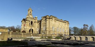
Saltaire is a Victorian model village in Shipley, part of the City of Bradford Metropolitan District, in West Yorkshire, England. The Victorian era Salt's Mill and associated residential district located by the River Aire and Leeds and Liverpool Canal is a designated UNESCO World Heritage Site and an Anchor Point of the European Route of Industrial Heritage.

<span class="mw-page-title-main">Shipley, West Yorkshire</span> Town and civil parish in West Yorkshire, England

Shipley is a historic market town and civil parish in the City of Bradford, West Yorkshire, England, by the River Aire and the Leeds and Liverpool Canal, north of Bradford. The population of the Shipley ward on Bradford City Council taken at the 2011 Census was 15,483.

<span class="mw-page-title-main">Baildon</span> Town and civil parish in West Yorkshire, England

Baildon is a town and civil parish in the Bradford Metropolitan Borough in West Yorkshire, England and within the historic boundaries of the West Riding of Yorkshire.

Clayton, or Clayton Village, is a civil parish in the City of Bradford metropolitan borough in West Yorkshire, England, situated 3 miles (4.8 km) to the west of Bradford city centre. It is listed in the Domesday Book, meaning it dates back to at least the 11th century and was privately owned from 1160 to 1866. It was noted for its clay. More recently, Clayton was a key location in the British and international wool trade, being the home of the British Wool Marketing Board headquarters. The old building was demolished and converted into housing in the late 1990s. The village re-acquired civil parish status with a parish council in 2004.

<span class="mw-page-title-main">Heaton, West Yorkshire</span> Human settlement in England

Heaton is a ward within the City of Bradford Metropolitan District Council, West Yorkshire, England. The population at the 2001 census was 16,913, which had increased to 17,121 at the 2011 Census. Historically part of the West Riding of Yorkshire, the ward includes the villages of Frizinghall, Heaton and Daisy Hill, extending to Chellow Heights Reservoir on the western edge and the Bradford-Shipley railway line on the eastern edge. Frizinghall railway station is on the edge of the ward.

<span class="mw-page-title-main">Lister Park</span> Public park in Bradford, West Yorkshire, England

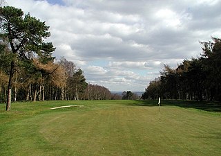
Lister Park is a picturesque public park in Bradford, West Yorkshire, England, between Manningham, Heaton and Frizinghall. It has won various national awards.

<span class="mw-page-title-main">Cottingley, Bradford</span> Village in West Yorkshire, England

Cottingley is a suburban village within the City of Bradford in West Yorkshire, England between Shipley and Bingley. It is known for the Cottingley Fairies, which appeared in a series of photographs taken there during the early 20th century.

<span class="mw-page-title-main">Heaton Woods</span>

The Heaton Woods Trust is both the name for the charity and the woodland it cares for located mainly in Heaton, Bradford, West Yorkshire, England but also stretches into Shipley. The Heaton Woods Trust is a registered charity that was established in 1977. The Heaton Woods Trust is responsible for the care and protection of the woods for the benefit of present and future generations.

<span class="mw-page-title-main">Holme Wood</span> Human settlement in England

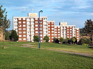
Holme Wood is a housing estate in Bradford, West Yorkshire, England.

<span class="mw-page-title-main">Bingley St Ives</span>

Bingley St. Ives, or St. Ives Estate is a 550-acre (2.2 km2) country park and former estate between Bingley and Harden in West Yorkshire, England now owned by Bradford Council. The park has Grade II listing in the English Heritage National Register of Historic Parks and Gardens of Special Interest. The park has been given Accredited Country Park status by Natural England.

<span class="mw-page-title-main">Thackley</span> Village in West Yorkshire, England

Thackley is a small suburb near Bradford, West Yorkshire in England. The village is loosely bordered by the village of Idle to the south, to the west by the West Royd area of Shipley and elsewhere by the Leeds and Liverpool Canal. Thackley is the northernmost part of Bradford south of the River Aire.

<span class="mw-page-title-main">Bradford</span> City in West Yorkshire, England

Bradford is a city and the administrative centre of the City of Bradford district in West Yorkshire, England. The city is in the Pennines' eastern foothills on the banks of the Bradford Beck. Bradford had a population of 349,561 at the 2011 census; the second-largest population centre in the county after Leeds, which is 9 miles (14 km) to the east of the city. It shares a continuous built-up area with the towns of Shipley, Silsden, Bingley and Keighley in the district as well as with the metropolitan county's other districts. Its name is also given to Bradford Beck.

Sir Henry Norman Rae was an English wool merchant and Liberal Party politician.

<span class="mw-page-title-main">Harden Beck</span> Beck in West Yorkshire, England

Harden Beck is a stream that flows from Hewenden Reservoir, over Goit Stock Waterfall to the River Aire in Bingley, West Yorkshire. The route starts out further up the valley as Denholme Beck, Hewenden Beck and Hallas Beck. Its waters are fed by Thornton Moor Reservoir, Stubden Reservoir, Doe Park Reservoir and Hewenden Reservoir.

<span class="mw-page-title-main">Bradford Beck</span> River in Bradford, West Yorkshire, England

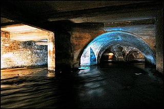
Bradford Beck is a river that flows through Bradford, West Yorkshire, England, and on to the River Aire at Shipley. As it reaches Bradford city centre it runs underground after being built over in the 19th century. It is culverted as it runs from Bradford city centre to Queen's Road after which it runs mostly in an open channel to Shipley. The beck used to be known as the filthiest river in England.

<span class="mw-page-title-main">Harden Moor</span> Moorland in West Yorkshire, England

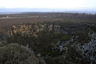
Harden Moor is an expanse of moorland that lies north of the village of Harden in West Yorkshire, England. The moor encompasses stretches of heather, woodland and former quarry workings and is bordered by Airedale to the east, the Worth Valley to the north and Catstones Moor and the village of Cullingworth to the west. Historically, Harden Moor occupied the high ground between Bingley, Keighley, Cullingworth and Harden. Altar Lane, an unmade road which runs from the Brown Cow Inn in Bingley to Keighley Road on Harden Moor is an unofficial border between the estate of St Ives and Harden Moor, but when the St Ives Estate was created, a large swathe of Harden Moor was taken over.

<span class="mw-page-title-main">Tyersal Beck</span> Stream in West Yorkshire, England

Tyersal Beck is a watercourse in West Yorkshire, England, named after the village of Tyersal in whose vicinity it runs.

<span class="mw-page-title-main">Holme Beck</span> River in England

Holme Beck is a watercourse in the Tong ward of the City of Bradford, West Yorkshire, England. It drains a shallow valley east of the watershed between Bradford and Leeds. Holme Beck begins in the village with no evidence of any continuation on the other side of the canal or motorway. Holme Beck is the main carrier for village drainage, it runs beneath the West Coast Main Line and then through the large marsh area of Holme Moss before joining the River Bela.

<span class="mw-page-title-main">Bradford Dale (Yorkshire)</span> Valley in West Yorkshire, England

Bradford Dale, is a side valley of Airedale that feeds water from Bradford Beck across the City of Bradford into the River Aire at Shipley in West Yorkshire, England. Whilst it is in Yorkshire and a dale, it is not part of the Yorkshire Dales and has more in common with Lower Nidderdale and Lower Airedale for its industrialisation.

References

  1. Stanford, Mark (17 January 2016). "Volunteers delve into Shipley's mining past". Bradford Telegraph and Argus. Retrieved 2 July 2018.
  2. "Northcliffe Park | Explore woods | The Woodland Trust". woodlandtrust.org. Retrieved 2 July 2018.
  3. Shuttleworth & Walker 2000, p. 54.
  4. Firth, Gary (1996). Shipley and Windhill. Stroud: Chalford. p. 49. ISBN   0-7524-0615-9.
  5. Shuttleworth & Walker 2000, p. 68.
  6. Shuttleworth & Walker 2000, p. 58.
  7. Shuttleworth & Walker 2000, p. 64.
  8. "Call to resurrect town's council". Bradford Telegraph and Argus. 7 April 1999. Retrieved 2 July 2018.
  9. 1 2 Shuttleworth & Walker 2000, p. 57.
  10. "288" (Map). Bradford & Huddersfield. 1:25,000. Explorer. Ordnance Survey. 2015. ISBN   9780319244852.
  11. "Bradford Parks & Landscape Service | Northcliffe Park". www.bradforddistrictparks.org. Retrieved 2 July 2018.
  12. "Friends of Northcliffe want to unveil more about Aire Valley's past". Bradford Telegraph and Argus. 25 November 2013. Retrieved 2 July 2018.
  13. "Walks Around Bradford's Becks" (PDF). aireriverstrust.org. April 2017. p. 10. Retrieved 2 July 2018.
  14. "Conservation". www.friendsofnorthcliffe.org.uk. Retrieved 2 July 2018.
  15. "Friends of Northcliffe Newsletter" (PDF). friendsofnorthcliffe.org.uk. August 2015. p. 3. Retrieved 2 July 2018.
  16. Young, Chris (14 April 2018). "Council urged to take action against developers who try to avoid biodiversity contributions". Bradford Telegraph and Argus. Retrieved 2 July 2018.
  17. "A Woodland Strategy For Bradford District" (PDF). bradford.moderngov.co.uk. p. 9. Retrieved 2 July 2018.
  18. "Northcliffe Woods, Shipley, West Yorkshire". megalithix.wordpress.com. 5 January 2013. Retrieved 2 July 2018.
  19. Baxter, Hannah (13 June 2010). "Model fun at Shipley gala". Bradford Telegraph and Argus. Retrieved 2 July 2018.
  20. Jagger, David (29 May 2018). "Shipley Street Arts Festival links up with Rae Gala to save both events". Bradford Telegraph and Argus. Retrieved 2 July 2018.
  21. 1 2 "Northcliff Railway : Bradford MES". www.bradfordmes.co.uk. Retrieved 2 July 2018.
  22. "It's wooded bliss as happy couple branch out". The Yorkshire Post. 8 August 2010. Retrieved 2 July 2018.

Sources