
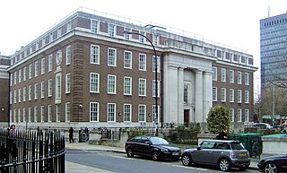
Barnard's Inn is a former Inn of Chancery in Holborn, London. It is now the home of Gresham College, an institution of higher learning established in 1597 that hosts public lectures.

The Worshipful Company of Fishmongers is one of the 110 Livery Companies of the City of London, being an incorporated guild of sellers of fish and seafood in the City. The Company ranks fourth in the order of precedence of City Livery Companies, thereby making it one of the Great Twelve City Livery Companies.

Gresham College is an institution of higher learning located at Barnard's Inn Hall off Holborn in Central London, England. It does not enroll students or award degrees. It was founded in 1597 under the will of Sir Thomas Gresham, and hosts over 140 free public lectures every year. Since 2001, all lectures have also been made available online.

The Angel, Islington, is a historic landmark and a series of buildings that have stood on the corner of Islington High Street and Pentonville Road in Islington, London, England. The land originally belonged to the Clerkenwell Priory and has had various properties built on it since the 16th century. An inn on the site was called the "Angel Inn" by 1614, and the crossing became generally known as "the Angel". The site was bisected by the New Road, which opened in 1756, and properties on the site have been rebuilt several times up to the 20th century. The corner site gave its name to Angel tube station, opened in 1901, and the surrounding Angel area of London.

Baker Street is a street in the Marylebone district of the City of Westminster in London. It is named after builder William Baker, who laid out the street in the 18th century. The street is most famous for its connection to the fictional detective Sherlock Holmes, who lived at a fictional 221B Baker Street address on the north of the street. The area was originally high class residential, but now is mainly occupied by commercial premises.

St Lawrence Jewry next Guildhall is a Church of England guild church in the City of London on Gresham Street, next to Guildhall. It was destroyed in the Great Fire of London in 1666, and rebuilt to the designs of Sir Christopher Wren. It is the official church of the Lord Mayor of London.

Gresham Street in the City of London is named after the English merchant and financier Thomas Gresham.

All Hallows, Honey Lane was a parish church in the City of London, England. Of medieval origin, it was destroyed in the Great Fire of London in 1666 and not rebuilt; the site became part of Honey Lane Market, which was in turn partially cleared to make way for the City of London School in the 19th century. Much of the area was destroyed during the bombing in World War II and has been redeveloped. The name Honey Lane is retained in a nearby walkway.
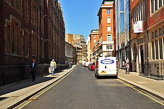
Chancery Lane is a one-way street situated in the ward of Farringdon Without in the City of London. It has formed the western boundary of the City since 1994, having previously been divided between the City of Westminster and the London Borough of Camden. The route originated as a 'new lane' created by the Knights Templar from their original 'old Temple' on the site of the present Southampton Buildings on Holborn, in order to access to their newly acquired property to the south of Fleet Street sometime before 1161.

Russia Row is a street in the City of London that runs between Milk Street and Trump Street on the northern side of the former Honey Lane Market. Russia Court, formerly Robin Hood Court, the home of the Russia Company, was once located on the northern side of the street and the City of London School on the south side. The street is thought to have received its name around 1804, shortly before Russia decided to enter the Napoleonic Wars on the same side as Britain. It was damaged by German bombing during the Second World War and has since been completely rebuilt.

Trump Street is a street in the City of London that was originally known as Trumpadere Street, probably after the trumpet or horn makers who once worked there or in the adjacent Trump Alley. It was built after the Great Fire of London (1666) but completely destroyed by bombing during the Second World War and has since been entirely rebuilt.

Lawrence Lane is a street in the City of London that runs from Trump Street in the south to Gresham Street in the north. Its final section in the north is pedestrianised. An alley also joins it to King Street in the north. It once ran south to join Cheapside but that end was blocked following post-Second World War rebuilding. It was known as St Lawrence Lane from the 13th to the 18th centuries due to its proximity to the church of St Lawrence Jewry and until King Street was built was the main route from Cheapside to the London Guildhall.

30 Gresham Street is an office building in Gresham Street in the City of London of 386,000 sq ft developed by Land Securities in 2002-03 and occupied by Commerzbank and Investec. When built, it was described as "the biggest speculative office development in the capital". The building is bounded in the south by Russia Row and Trump Street, in the east by Lawrence Lane, and in the west by Milk Street. It is on the site of the former Blossom's Inn as well as a number of other small alleys and courts such as Robin Hood Court, Russia Court, Mumford Court and Castle Court.

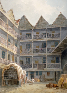
The Swan with Two Necks was a coaching inn in the City of London that, until the arrival of the railways, was one of the principal departure points for travel to the north of England from London. Its site was given over in the early 1860s to a goods and parcels depot for a firm of railway agents and carriers.
The Bull and Mouth Inn was a coaching inn in the City of London that dated from before the Great Fire of London in 1666. It was located between Bull and Mouth Street in the north and Angel Street in the south. It was once an important arrival and departure point for coaches from all over Britain, but particularly for the north of England and Scotland. It became the Queen's Hotel in 1830 but was demolished in 1887 or 1888 when new post office buildings were built in St Martin's Le Grand.

Bull and Mouth Street was a street in the City of London that ran between Edward Street and St Martin's Le Grand. On part of its site stands Postman's Park.

Milk Street in the City of London, England, was the site of London's medieval milk market. It was the location of the parish church of St Mary Magdalen which was destroyed in the Great Fire of London in 1666 and then of Honey Lane Market and the City of London School. The street was seriously damaged by German bombing during the Second World War and has since been completely rebuilt. Nothing remains of its former buildings.

Honey Lane Market was an historic market near Cheapside in the City of London.
Endsleigh Gardens is a street in the Bloomsbury district of central London, in the London Borough of Camden. It runs south-west to north-east from Gordon Street to Woburn Place. The south-west end becomes Gower Place after the junction with Gordon Street. Taviton Street and Endsleigh Street run off the south side.

Oakley Street is in the Royal Borough of Kensington and Chelsea, London. It runs roughly north to south from King's Road to the crossroads with Cheyne Walk and the River Thames, where it continues as the Albert Bridge and Albert Bridge Road. The street was named after Baron Cadogan of Oakley.


