Groyne

Last updated
Groynes in Sitges, Catalonia, Spain 53sitges.jpg
Groynes in Sitges, Catalonia, Spain

A groyne (in the U.S. groin) is a rigid hydraulic structure built perpendicularly from an ocean shore (in coastal engineering) or a river bank, interrupting water flow and limiting the movement of sediment. It is usually made out of wood, concrete, or stone. In the ocean, groynes create beaches, prevent beach erosion caused by longshore drift where this is the dominant process and facilitate beach nourishment. There is also often cross-shore movement which if longer than the groyne will limit its effectiveness. In a river, groynes slow down the process of erosion and prevent ice-jamming, which in turn aids navigation.

Contents

Groynes run generally perpendicular to the shore, extending from the upper foreshore or beach into the water. All of a groyne may be underwater, in which case it is a submerged groyne. They are often used in tandem with seawalls and other coastal engineering features. Groynes, however, may cause a shoreline to be perceived as unnatural. Groynes are generally straight but could be of various plan view shapes, permeable or impermeable, built from various materials such as wood, sand, stone rubble, or gabion, etc.

Background

Etymology

The term groyne is derived from the Old French groign, from Late Latin grunium, "snout". [1]

History

Ancient Egypt and Nubia

A large number of groynes were found along a 1,000-kilometre stretch of the river Nile, between the first and the fourth cataract. [2] The earliest ones dated so far were found to be over 3,000 years old, but researchers are hypothising that the technique might already have been understood in the fourth millennium BCE. [2] The newly discovered groynes are located in what are now Egypt (Aswan), but mainly in Sudan, in areas of ancient Nubia, some of them built by the Egyptian overlords and some possibly the work of local Nubians. [2]

16th- to 19th-century England

One of the earliest mentions of groynes is in connection with the planned improvements to the silted-up Dover harbour, by one Fernando Poyntz in 1582. [3] [4] [5]

In 1713 the first wooden groyne to protect Brighton's seafront and coastline was built, which had been heavily damaged in the Great storm of 1703, and again in 1705. [6] In 1867, the first concrete groyne was built near East Street, Brighton as a promenade 195 feet (59 m) long. [7]

Mechanics

Rock groyne at Sea Bright Beach, New Jersey. Sea Bright Beach Jetty.jpg
Rock groyne at Sea Bright Beach, New Jersey.

Beach evolution and sedimentation accretion

A groyne gradually creates and maintains a wide area of beach on its updrift side by trapping the sediments suspended in the ocean current. This process is called accretion of sand and gravel or beach evolution. It reduces erosion on the other, i.e. downdrift, side by reducing the speed and power of the waves striking the shore. It is a physical barrier to stop sediment transport in the direction of longshore drift (also called longshore transport). If a groyne is correctly designed, then the amount of material it can hold will be limited, and excess sediment will be free to move on through the system. However, if a groyne is too large it may trap too much sediment, which can cause severe beach erosion on the down-drift side.

Groyne fields

Groynes are generally placed in series, generally all perpendicular to the shore. The areas between groups of groynes are groyne fields.

Terminal groyne syndrome

A poorly designed groyne (too long and not suited to the unique features of the coast) can also accelerate the erosion of the downdrift beach, which receives little or no sand from longshore drift. This process is known as terminal groyne syndrome, because in a series of groynes it occurs after the terminal groyne (last groyne on the downdrift side of the beach or coastline).

Headland groyne / Headland breakwater

A breakwater is an artificial offshore structure built parallel to the shore -- similar to naturally formed barrier islands -- that normally remains unattached to the shore. When a groyne is built to attach the breakwater to the shore, it is called a "headland groyne", also known as "bulkhead groyne", "headland breakwater", "T-head groyne", or "T-shaped groyne".

Usage

Coastal management

Wooden groyne, Mundesley, UK Groyne at Mundesley, Norfolk.JPG
Wooden groyne, Mundesley, UK

A groyne's length and elevation, and the spacing between groynes is determined according to local wave energy and beach slope. Groynes that are too long or too high tend to accelerate downdrift erosion, and are ineffective because they trap too much sediment. Groynes that are too short, too low, or too permeable are ineffective because they trap too little sediment. If a groyne does not extend far enough landward, water (for example at a high tide combined with a storm surge) may flow past the landward end and erode a channel bypassing the groyne, a process known as flanking.

River management

Aerial photograph of the Lumberville Dam on the Delaware River. Some water is pouring over the wing dams or groins; there is a navigation channel between them. BullsIslandNJ-aerial-hi.svg
Aerial photograph of the Lumberville Dam on the Delaware River. Some water is pouring over the wing dams or groins; there is a navigation channel between them.

River groynes (spur dykes, wing dykes, or wing dams) are often constructed nearly perpendicular to the riverbanks, beginning at a riverbank with a root and ending at the regulation line with a head. They maintain a channel to prevent ice jamming, and more generally improve navigation and control over lateral erosion, that would form from meanders. Groynes have a major impact on the river morphology: they cause autonomous degradation of the river. [8]

They are also used around bridges to prevent bridge scour.

Types

Submerged groin (US spelling), Hunting Island, South Carolina Groin.jpg
Submerged groin (US spelling), Hunting Island, South Carolina
A "Keep off the groynes" sign in Brighton, England, with a groyne showing in the background. BrightonGroynes5890.JPG
A "Keep off the groynes" sign in Brighton, England, with a groyne showing in the background.

Groynes can be distinguished by how they are constructed, whether they are submerged, their effect on stream flow or by shape. [9]

By their planview shape

Groynes can be built with different planview shapes. Some examples include straight groynes, hockey stick or curved, inverted hockey stick groynes, tail or checkmark shaped groynes, L head, straight groynes with pier head (seaward end raised on the stilts, since the pier head is raised on the stilts it does not act as the breakwater), T-head (headland groyne, breakwater attached to the shore with straight groyne, the head/breakwater itself could be shaped straight, Y-shaped, arrow or wing shaped head).

By cross-section based on material used

Wooden groynes, sheetpile groynes, sandbag groynes, rubble mound or gabion groynes, etc.

By permeability

Groynes can be permeable, allowing the water to flow through at reduced velocities, or impermeable, blocking and deflecting the current.

By whether they are submerged

Groynes can be submerged or not under normal conditions. Usually impermeable groynes are non-submerged, since flow over the top of solid groynes may cause severe erosion along the shanks. Submerged groynes, on the other hand, may be permeable depending on the degree of flow disturbance needed.

By their effect on stream flow

Groynes can be attracting, deflecting or repelling.

See also

Related Research Articles

<span class="mw-page-title-main">Beach</span> Area of loose particles at the edge of the sea or other body of water

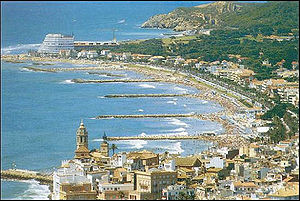
A beach is a landform alongside a body of water which consists of loose particles. The particles composing a beach are typically made from rock, such as sand, gravel, shingle, pebbles, etc., or biological sources, such as mollusc shells or coralline algae. Sediments settle in different densities and structures, depending on the local wave action and weather, creating different textures, colors and gradients or layers of material.

<span class="mw-page-title-main">Coastal erosion</span> Displacement of land along the coastline

Coastal erosion is the loss or displacement of land, or the long-term removal of sediment and rocks along the coastline due to the action of waves, currents, tides, wind-driven water, waterborne ice, or other impacts of storms. The landward retreat of the shoreline can be measured and described over a temporal scale of tides, seasons, and other short-term cyclic processes. Coastal erosion may be caused by hydraulic action, abrasion, impact and corrosion by wind and water, and other forces, natural or unnatural.

<span class="mw-page-title-main">Spit (landform)</span> Coastal bar or beach landform deposited by longshore drift

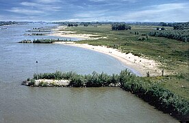
A spit or sandspit is a deposition bar or beach landform off coasts or lake shores. It develops in places where re-entrance occurs, such as at a cove's headlands, by the process of longshore drift by longshore currents. The drift occurs due to waves meeting the beach at an oblique angle, moving sediment down the beach in a zigzag pattern. This is complemented by longshore currents, which further transport sediment through the water alongside the beach. These currents are caused by the same waves that cause the drift.

<span class="mw-page-title-main">Longshore drift</span> Sediment moved by the longshore current

Longshore drift from longshore current is a geological process that consists of the transportation of sediments along a coast parallel to the shoreline, which is dependent on the angle of incoming wave direction. Oblique incoming wind squeezes water along the coast, and so generates a water current which moves parallel to the coast. Longshore drift is simply the sediment moved by the longshore current. This current and sediment movement occur within the surf zone. The process is also known as littoral drift.

<span class="mw-page-title-main">Beach nourishment</span> Sediment replacement process

Beach nourishment describes a process by which sediment, usually sand, lost through longshore drift or erosion is replaced from other sources. A wider beach can reduce storm damage to coastal structures by dissipating energy across the surf zone, protecting upland structures and infrastructure from storm surges, tsunamis and unusually high tides. Beach nourishment is typically part of a larger integrated coastal zone management aimed at coastal defense. Nourishment is typically a repetitive process since it does not remove the physical forces that cause erosion but simply mitigates their effects.

<span class="mw-page-title-main">Breakwater (structure)</span> Coastal defense structure

A breakwater is a permanent structure constructed at a coastal area to protect against tides, currents, waves, and storm surges. Breakwaters have been built since Antiquity to protect anchorages, helping isolate vessels from marine hazards such as wind-driven waves. A breakwater, also known in some contexts as a jetty or a Mole, may be connected to land or freestanding, and may contain a walkway or road for vehicle access.

<span class="mw-page-title-main">Coastal geography</span> Study of the region between the ocean and the land

Coastal geography is the study of the constantly changing region between the ocean and the land, incorporating both the physical geography and the human geography of the coast. It includes understanding coastal weathering processes, particularly wave action, sediment movement and weather, and the ways in which humans interact with the coast.

<span class="mw-page-title-main">Coastal management</span> Preventing flooding and erosion of shorelines

Coastal management is defence against flooding and erosion, and techniques that stop erosion to claim lands. Protection against rising sea levels in the 21st century is crucial, as sea level rise accelerates due to climate change. Changes in sea level damage beaches and coastal systems are expected to rise at an increasing rate, causing coastal sediments to be disturbed by tidal energy.

<span class="mw-page-title-main">Swash</span> A turbulent layer of water that washes up on the beach after an incoming wave has broken

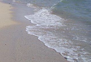
Swash, or forewash in geography, is a turbulent layer of water that washes up on the beach after an incoming wave has broken. The swash action can move beach materials up and down the beach, which results in the cross-shore sediment exchange. The time-scale of swash motion varies from seconds to minutes depending on the type of beach. Greater swash generally occurs on flatter beaches. The swash motion plays the primary role in the formation of morphological features and their changes in the swash zone. The swash action also plays an important role as one of the instantaneous processes in wider coastal morphodynamics.

<span class="mw-page-title-main">Goleta Beach</span>

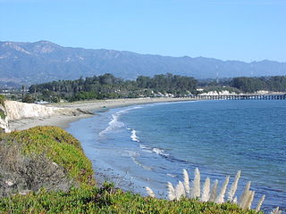
Goleta Beach is a region of coastline located near Goleta, California, just east of the University of California, Santa Barbara (UCSB) campus. A portion of the shore of Goleta Bay is managed by the County of Santa Barbara, as the Goleta Beach County Park (GBCP). The beach itself is partly man-made as sand was spread onto an existing sandspit in 1945. The beach is a seasonal habitat for migrating shorebirds, including the snowy plover, an endangered species, and is occasionally closed due to nourishment efforts.

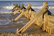
Hard engineering involves the construction of hydraulic structures to protect coasts from erosion. Such structures include seawalls, gabions, breakwaters, groynes and tetrapods.

<span class="mw-page-title-main">Cuspate foreland</span> Geographical features found on coastlines and lakeshores

Cuspate forelands, also known as cuspate barriers or nesses in Britain, are geographical features found on coastlines and lakeshores that are created primarily by longshore drift. Formed by accretion and progradation of sand and shingle, they extend outwards from the shoreline in a triangular shape.

Beach evolution occurs at the shoreline where sea, lake or river water is eroding the land. Beaches exist where sand accumulated from centuries-old, recurrent processes that erode rocky and sedimentary material into sand deposits. River deltas deposit silt from upriver, accreting at the river's outlet to extend lake or ocean shorelines. Catastrophic events such as tsunamis, hurricanes, and storm surges accelerate beach erosion.

<span class="mw-page-title-main">Sedimentary budget</span>

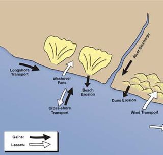
Sedimentary budgets are a coastal management tool used to analyze and describe the different sediment inputs (sources) and outputs (sinks) on the coasts, which is used to predict morphological change in any particular coastline over time. Within a coastal environment the rate of change of sediment is dependent on the amount of sediment brought into the system versus the amount of sediment that leaves the system. These inputs and outputs of sediment then equate to the total balance of the system and more than often reflect the amounts of erosion or accretion affecting the morphology of the coast.

<span class="mw-page-title-main">Sand dune stabilization</span> Coastal management practice

Sand dune stabilization is a coastal management practice designed to prevent erosion of sand dunes. Sand dunes are common features of shoreline and desert environments. Dunes provide habitat for highly specialized plants and animals, including rare and endangered species. They can protect beaches from erosion and recruit sand to eroded beaches. Dunes are threatened by human activity, both intentional and unintentional. Countries such as the United States, Australia, Canada, New Zealand, the United Kingdom, and Netherlands, operate significant dune protection programs.

<span class="mw-page-title-main">Coastal engineering</span> Branch of civil engineering

Coastal engineering is a branch of civil engineering concerned with the specific demands posed by constructing at or near the coast, as well as the development of the coast itself.

<span class="mw-page-title-main">Canterbury Bight</span> Oceanic bight in Canterbury, New Zealand

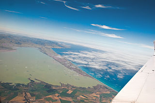
The Canterbury Bight is a large bight on the eastern side of New Zealand's South Island. The bight runs for approximately 135 kilometres (84 mi) from the southern end of Banks Peninsula to the settlement of Timaru and faces southeast, exposing it to high-energy storm waves originating in the Pacific Ocean. The bight is known for rough conditions as a result, with wave heights of over 2 metres (6.6 ft) common. Much of the bight's geography is shaped by this high-energy environment interacting with multiple large rivers which enter the Pacific in the bight, such as the Rakaia, Ashburton / Hakatere, and Rangitata Rivers. Sediment from these rivers, predominantly Greywacke, is deposited along the coast and extends up to 50 kilometres (31 mi) out to sea from the current shoreline. Multiple hapua, or river-mouth lagoons, can be found along the length of the bight where waves have deposited sufficient sediment to form a barrier across a river mouth, including most notably Lake Ellesmere / Te Waihora and Washdyke Lagoon

A coastal development hazard is something that affects the natural environment by human activities and products. As coasts become more developed, the vulnerability component of the equation increases as there is more value at risk to the hazard. The likelihood component of the equation also increases in terms of there being more value on the coast so a higher chance of hazardous situation occurring. Fundamentally humans create hazards with their presence. In a coastal example, erosion is a process that happens naturally on the Canterbury Bight as a part of the coastal geomorphology of the area and strong long shore currents. This process becomes a hazard when humans interact with that coastal environment by developing it and creating value in that area.

Coastal sediment supply is the transport of sediment to the beach environment by both fluvial and aeolian transport. While aeolian transport plays a role in the overall sedimentary budget for the coastal environment, it is paled in comparison to the fluvial supply which makes up 95% of sediment entering the ocean. When sediment reaches the coast it is then entrained by longshore drift and littoral cells until it is accreted upon the beach or dunes.

<span class="mw-page-title-main">Hapua</span>

A hapua is a river-mouth lagoon on a mixed sand and gravel (MSG) beach, formed at the river-coast interface where a typically braided, although sometimes meandering, river interacts with a coastal environment that is significantly affected by longshore drift. The lagoons which form on the MSG coastlines are common on the east coast of the South Island of New Zealand and have long been referred to as hapua by Māori people. This classification differentiates hapua from similar lagoons located on the New Zealand coast termed waituna.

References

  1. "Groyne | Meaning of Groyne by Lexico". Lexico Dictionaries | English. Archived from the original on February 22, 2020.
  2. 1 2 3 Ancient Egyptian hydraulic engineering shown in walls along Nile - study, Aaron Reich for The Jerusalem Post, June 21, 2023. For original scientific article published on 27 May 2023, see here.
  3. "groyne, n." . OED Online. Oxford University Press. December 2021. Retrieved 18 February 2022. Subscription or UK public library membership needed.
  4. Lemon, Robert, ed. (1865). Calendar of State Papers, Domestic series, of the reign of Elizabeth, 1581–1590. London: Longman, Green, Longman, Roberts and Green. pp. 44, 59, 67, 77, 80, 96. There were complaints by 1583 that the haven was in a worse state than in 1575 (p. 96); Poyntz was sidelined and the work was finished by Thomas Digges.
  5. Ash, Eric H. (2004). Power, Knowledge, and Expertise in Elizabethan England. Baltimore: Johns Hopkins University Press. pp. 55–86. ISBN   0801879922.
  6. Erredge, John Ackerson (1862). History of Brighthelmston or, Brighton as I view it and others knew it. Brighton: Printed by E. Lewis, "Observer" office. pp. 73–77.
  7. Gray, Fred (2011). "Three Views of Brighton as Port and Resort". In Borsay, Peter; Walton, John K. (eds.). Resorts and Ports: European Seaside Towns Since 1700. Bristol, Buffalo, Toronto: Channel View Publications. p. 74. ISBN   9781845411978.
  8. Yossef (2005)
  9. Przedwojski et al. (1995)

Notes