
St. Clair is a subway station on Line 1 Yonge–University in Toronto, Ontario, Canada. The station opened in 1954 as part of the original Yonge Street subway.
The Toronto Suburban Railway was a Canadian electric railway operator with local routes in west Toronto, and a radial (interurban) route to Guelph.

Toronto Civic Railways (TCR) was a streetcar operator created and owned by the City of Toronto, Ontario, Canada, to serve newly annexed areas of the city that the private operator Toronto Railway Company refused to serve. When the Toronto Railway Company's franchise expired in 1921, its services were combined with those of the Toronto Civic Railways, and are now assumed by the new Toronto Transportation Commission (TTC). The first route of the TCR started operation on December 18, 1912.

Keele Street is a north–south road in Toronto, Vaughan and King in Ontario, Canada. It stretches 47 kilometres (29 mi), running from Bloor Street in Toronto to the Holland Marsh. South of Bloor Street, the roadway is today known as Parkside Drive, but was originally part of Keele Street. It was renamed in 1921 by the City of Toronto.

The Toronto streetcar system is a network of eleven streetcar routes in Toronto, Ontario, Canada, operated by the Toronto Transit Commission (TTC). It is the third busiest light-rail system in North America. The network is concentrated primarily in Downtown Toronto and in proximity to the city's waterfront. Much of the streetcar route network dates from the 19th century. Three streetcar routes operate in their own right-of-way, one in a partial right-of-way, and six operate on street trackage shared with vehicular traffic with streetcars stopping on demand at frequent stops like buses. Since 2019, the network has used low-floor streetcars, making it fully accessible.

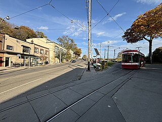
The 512 St. Clair is an east–west streetcar route in Toronto, Ontario, Canada, operated by the Toronto Transit Commission (TTC). It operates on St. Clair Avenue between St. Clair station on the Line 1 Yonge–University subway and Gunns Road, just west of Keele Street.

The 511 Bathurst is a Toronto streetcar route operated by the Toronto Transit Commission in Ontario, Canada.

506 Carlton is a Toronto streetcar route run by the Toronto Transit Commission in Ontario, Canada. It runs from Main Street station on subway Line 2 Bloor–Danforth along Gerrard, Carlton and College Streets to High Park. Despite the route's name, less than 10 percent of its length actually uses Carlton Street.

The 505 Dundas is a Toronto streetcar route run by the Toronto Transit Commission in Ontario, Canada. The route is roughly U-shaped running mainly along Dundas Street between Dundas West and Broadview stations several blocks south of the Line 2 Bloor–Danforth subway.

The 502 Downtowner was a streetcar route operated by the Toronto Transit Commission in Toronto, Ontario, Canada. It ran from the Bingham Loop at Victoria Park Avenue and Kingston Road in the Beaches neighbourhood to McCaul Loop in downtown Toronto. Starting in September 2019, all streetcar services along Kingston Road were consolidated into the 503 Kingston Rd route.

Turning loops of the Toronto streetcar system serve as termini and turnback points for streetcar routes in Toronto, Ontario, Canada. The single-ended streetcars require track loops in order to reverse direction. Besides short off-street track loops these can also be larger interchange points, having shelters and driver facilities, or be part of a subway station structure for convenient passenger interchange.
Neville Park Loop is the eastern terminus of the 301/501 Queen streetcar line, the longest streetcar route of the Toronto Transit Commission (TTC). It is also the terminus of the 143 Beaches/Downtown express bus service. It is located at the southwest corner of Queen Street East and Nursewood Road in the Beaches neighbourhood of Toronto. It is named after the street which is just west of the loop.

Bingham Loop is a station and turning loop at the eastern terminus of the 503 Kingston Rd streetcar lines of the Toronto Transit Commission (TTC). It lies between Victoria Park Avenue and Bingham Avenue, just north of Kingston Road in Toronto.

Long Branch Loop is the westernmost streetcar stop within the Toronto streetcar system, operated by the Toronto Transit Commission (TTC). It is located in the Long Branch neighbourhood in southwestern Toronto, close to the boundary with Mississauga. Long Branch Loop is the western terminus for four streetcar routes but is principally served by the 507 Long Branch route. Several TTC and MiWay bus routes terminate at the loop.
Jane Loop was an important Toronto Transit Commission (TTC) streetcar turning loop and bus station, prior to the completion of the Bloor Danforth Subway line. The Jane Loop opened on December 31, 1923; it was the western end of Bloor Streetcar line from 1925 to 1968. The loop was at a boundary between two zones in the TTC's zoned fare system. Half a dozen or so buses and trolleybuses terminated at the loop.
The Rogers Road streetcar line was a streetcar line that operated mainly within the Township of York from 1924 to 1974. The line was owned by the Township of York Railways, which in turn was owned by its namesake municipality. The Township of York Railways contracted with the Toronto Transportation Commission, later the Toronto Transit Commission (TTC), to operate the line.

The Harbord streetcar line was an east-west line within the Toronto streetcar system. The route was named after Harbord Street even though only a small portion of the route was along the namesake street. One distinct characteristic of the route was its zip-zag nature, making many 90-degree turns onto the various streets along its route. The route was retired in 1966 when the Toronto Transit Commission (TTC) opened the Bloor–Danforth subway line, the city's first east-west subway line.

The St. Clair Carhouse was a streetcar facility in Toronto, Ontario, Canada. It was located south of St. Clair Avenue on a parcel of land bounded by Wychwood Avenue on the east, Benson Avenue on its north side and Christie Street on the west side. It was opened by the Toronto Civic Railways in 1913, taken over by the Toronto Transportation Commission in 1921 and closed by its successor, the Toronto Transit Commission, in 1998. The carhouse was subsequently transformed into a community centre called the Wychwood Barns.
St. Clair–Old Weston GO Station is a planned commuter train station in Toronto, Ontario, Canada. It will be an infill station on the Kitchener line of GO Transit located between Bloor GO station and the future Mount Dennis station. The station is one of five GO stations to be built as part of the SmartTrack Stations Program to adapt regional commuter service for urban public transit. The construction contract was awarded in 2022; construction is to start in January 2024 for completion in March 2029.

