The Toronto subway is a rapid transit system serving Toronto and the neighbouring city of Vaughan in Ontario, Canada, operated by the Toronto Transit Commission (TTC). As of September 2023, the subway system is a rail network consisting of three heavy-capacity rail lines operating predominantly underground. As of December 2022, three new lines are under construction: two light rail lines and one light metro line.

Eglinton West is a subway station on Line 1 Yonge–University in Toronto, Ontario, Canada. It is located in the median of Allen Road on the north side of Eglinton Avenue West.

Eglinton is a subway station on Line 1 Yonge–University of the Toronto subway. Located on Eglinton Avenue, it is central to the Yonge–Eglinton neighbourhood in Midtown Toronto. Eglinton station is the seventh busiest station of the Toronto Transit Commission (TTC).

Kennedy is the eastern terminal station on Line 2 Bloor–Danforth of the Toronto subway system. Opened in 1980, it is located east of the Kennedy Road and Eglinton Avenue intersection. With the adjacent Kennedy GO station on the Stouffville line of GO Transit, Kennedy is an intermodal transit hub and the fifth busiest station in the system, after Bloor–Yonge, St. George, Sheppard–Yonge, and Union, serving a total of approximately 113,961 customer trips a day.

Line 5 Eglinton is a light rail line that is under construction in Toronto, Ontario, Canada. Owned by Metrolinx and operated by the Toronto Transit Commission (TTC), the line will be part of the Toronto subway system as its fifth route. The first phase of the 19-kilometre (12 mi) line will include 25 stops along Eglinton Avenue, from Mount Dennis station mostly underground to Laird station, after which it will run predominantly at-grade within the street's median to Kennedy station, where it will connect underground with Line 2 Bloor–Danforth. The second phase, a 9.2-kilometre (5.7 mi) westward extension from Mount Dennis, will run mostly underground or elevated to Renforth station, with seven new stations.
Line 6 Finch West, also known as the Finch West LRT, is a light rail line under construction in Toronto, Ontario, Canada, to be operated by the Toronto Transit Commission. The 10.3-kilometre (6.4 mi), 18-stop line is to extend from Finch West station on Line 1 Yonge–University to the North Campus of Humber College in Etobicoke. The line will operate in a dedicated above-ground right-of-way, much of it within Finch Avenue, segregated from street traffic. The line will use transit signal priority and standard gauge rather than the broad Toronto gauge. The line is forecast to carry about 14.6 million rides a year or 40,000 a day by 2031 and will replace the 36 Finch West bus route, which is one of the three busiest bus routes in Toronto. Line 6 is expected to open within the first half of 2024, with an estimated cost of CA$2.5 billion. For budget purposes, the TTC made the assumption that Line 6 would open no earlier than September 2024.
Mount Dennis is an intermodal transit terminal under construction in Toronto, Ontario, Canada. Located east of the intersection of Eglinton Avenue and Weston Road in the Mount Dennis neighbourhood in the district of York, the station will be the western terminus of the future Line 5 Eglinton as well as an intermediate station on the GO Transit Kitchener line and Union Pearson Express. The station has been designated as one of many "mobility hubs" in Greater Toronto. It is scheduled to open in 2024.

Keelesdale is an underground light rail transit (LRT) station under construction on Line 5 Eglinton, a new line that will be part of the Toronto subway system. It will be located in the Silverthorn neighbourhood at the intersection of Keele Street and Eglinton Avenue and is scheduled to open in 2024. Nearby destinations include the York Civic Centre, Keelesdale Park and Chris Tonks Arena, York Memorial Collegiate Institute, George Harvey Collegiate Institute, and the Silverthorn neighbourhood.

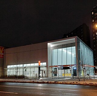
Caledonia is an underground light rail transit (LRT) station under construction on Line 5 Eglinton, a new line that is part of the Toronto subway system. It will be located along Eglinton Avenue between the GO Transit Barrie rail corridor and the entrance to the Westside Mall. This is about 200 metres (660 ft) west of Caledonia Road opposite Blackthorn Avenue.
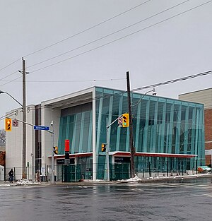
Fairbank is an underground light rail transit (LRT) station under construction on Line 5 Eglinton, a new line that is part of the Toronto subway system. It will be located in the Fairbank neighbourhood at the intersection of Dufferin Street and Eglinton Avenue West. Destinations include the Fairbank neighbourhood and Fairbank Memorial Park. As of 2017, construction work related to the station was in progress, having been scheduled to begin in 2014. The station is scheduled to open in 2024.

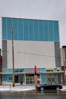
Oakwood is an underground light rail transit (LRT) station under construction on Line 5 Eglinton, a new line that is part of the Toronto subway system. It will be located in the Little Jamaica neighbourhood at the intersection of Oakwood Avenue and Eglinton Avenue. It is scheduled to open in 2024.

Forest Hill is an underground light rail transit (LRT) station under construction on Line 5 Eglinton, a new line that is part of the Toronto subway system. It will be located in the Forest Hill neighbourhood at the intersection of Bathurst Street and Eglinton Avenue. It is scheduled to open no earlier than 2024.
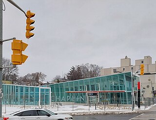
Chaplin is an underground light rail transit (LRT) station under construction on Line 5 Eglinton, a new line that is part of the Toronto subway system. It will be located in the Forest Hill neighbourhood at the intersection of Chaplin Crescent and Eglinton Avenue, and is scheduled to open in 2024.

Mount Pleasant is an underground light rail transit (LRT) station under construction on Line 5 Eglinton, a new line that is part of the Toronto subway system. The station will be located in North Toronto at the intersection of Mount Pleasant Road and Eglinton Avenue. Nearby destinations include Northern Secondary School, North Toronto Collegiate Institute, and the Davisville Village neighbourhood. It is scheduled to open in 2024.

Leaside is an underground light rail transit (LRT) station under construction on Line 5 Eglinton, a new line that is part of the Toronto subway system. It is located in the Leaside neighbourhood at the intersection of Bayview Avenue and Eglinton Avenue. It is scheduled to open in 2024.

Laird is an underground light rail transit (LRT) station under construction on Line 5 Eglinton, a new line that is part of the Toronto subway system. It is located in the Leaside neighbourhood in East York at the intersection of Laird Drive and Eglinton Avenue. It is scheduled to open in 2024.

Science Centre is an underground light rail transit (LRT) station and mobility hub under construction on Line 5 Eglinton, a new line that is part of the Toronto subway system. It will be located in the Flemingdon Park neighbourhood at the intersection of Don Mills Road and Eglinton Avenue. It is scheduled to open in 2024.

Sunnybrook Park is a surface light rail transit stop under construction on Line 5 Eglinton, a future line that will be part of the Toronto subway system. It will be located at the intersection of Leslie Street and Eglinton Avenue. The intersection is largely surrounded by park lands in the valley of the West Branch of the Don River, which includes destinations such as E.T. Seton Park, Serena Gundy Park, Wilket Creek Park, Sunnybrook Park and Edwards Gardens. This will be the westernmost at-grade surface stop. The station is scheduled to open in 2024.
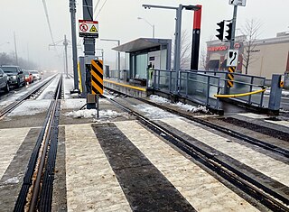
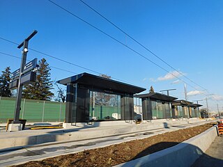
Hakimi Lebovic is a surface light rail transit (LRT) stop under construction on Line 5 Eglinton, a new line that is part of the Toronto subway system. It will be located in the Golden Mile neighbourhood at the intersection of Eglinton Avenue and Lebovic and Hakimi Avenues. It is scheduled to open in 2024.

Renforth, referred to during planning as Renforth Gateway, is a bus station on the border of the cities of Mississauga and Toronto, in Ontario, Canada. Located at Eglinton Avenue and Renforth Drive, it is the eastern terminus of the Mississauga Transitway and is close to the interchange between Highway 401 and Highway 427.