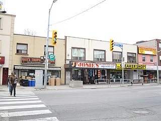
Yonge–Eglinton is a neighbourhood in Toronto, Ontario, Canada, at the intersection of Yonge Street and Eglinton Avenue. It is central to the area of Midtown Toronto, one of four central business districts outside Downtown Toronto. The City of Toronto defines its boundaries as Briar Hill Avenue to the north, Yonge Street to the east, Frobisher Avenue and a line in that direction west to Elmsthorpe Avenue, then north to Eglinton Avenue, east to Avenue Road and north to Briar Hill.

North Toronto is a former town and informal district located in the northern part of the Old Toronto district in Toronto, Ontario, Canada. Currently occupying a geographically central location within the city of Toronto, the Town of North Toronto was incorporated in 1890, when much of the area was still farmland, and annexed by the old city of Toronto in 1912. The name is still used to refer to the area in general, although Yonge–Eglinton and Midtown Toronto are officially used.

Spadina Avenue is one of the most prominent streets in Toronto, Ontario, Canada. Running through the western section of downtown, the road has a very different character in different neighbourhoods.

Lawrence Park is a neighbourhood in Toronto, Ontario, Canada. It is bordered by Yonge Street to the west and Bayview Avenue to the east, and from Blythwood Ravine on the south to Lawrence Avenue on the north. Lawrence Park was one of Toronto's first planned garden suburbs. Begun in the early part of the 20th century, it did not fully develop until after the Second World War. It was ranked the wealthiest neighbourhood in all of Canada in 2011.
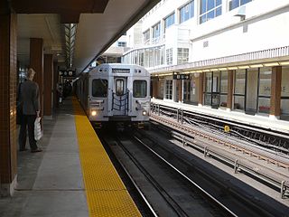
Davisville is a subway station on Line 1 Yonge–University in Toronto, Ontario, Canada. It is located at 1900 Yonge Street at Chaplin Crescent/Davisville Avenue. The station opened in 1954 as part of the original Toronto subway. In 2002, this station became accessible with elevators.

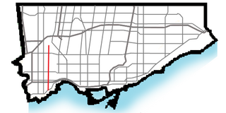
Lawrence Avenue is a major east-west thoroughfare in Toronto, Ontario, Canada. It is divided into east and west portions by Yonge Street, the dividing line of east-west streets in Toronto.

Sheppard Avenue is an east–west principal arterial road in Toronto, Ontario, Canada. The street has two distinct branches near its eastern end, with the original route being a collector road leading to Pickering via a turnoff, and the main route following a later-built roadway which runs south to Kingston Road. To avoid name duplication, the Toronto portion of the northern branch was renamed Twyn Rivers Drive. The section of the street entirely in Toronto is (34.2 km) in length, while the Pickering section and Twyn Rivers Dr. is (5.4 km) long.

The Davisville Subway Yard is a rail yard on the Toronto Transit Commission's Yonge subway line. The train maintenance and storage building is referred to as the Davisville Carhouse.
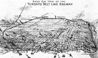
The Toronto Belt Line Railway was built during the 1890s in Toronto, Ontario, Canada. It consisted of two commuter railway lines to promote and service new suburban neighbourhoods outside of the then city limits. Both lines were laid as loops. The longer Don Loop ran north of the city limits, while the shorter Humber Loop ran west of the city limits. The railway was never profitable and it only ran for two years. Today, as part of a rails-to-trails project, the Beltline Trail lies on the right-of-way of the Don Loop.
Bedford Park is a neighbourhood just outside the downtown core of Toronto. It borders Lawrence Park which was ranked Canada's wealthiest neighbourhood in 2011. The City of Toronto's neighbourhood definitions places most of Bedford Park, including Bedford Park Avenue in the Lawrence Park North Planning Neighbourood and the remaining western and northern portions of Bedford Park within a larger neighbourhood, called Bedford Park-Nortown. The border of this larger area extend to Bathurst Street on the west, Highway 401 to the north, Hillhurst Boulevard to the south, and zigzags from northeast to southwest along Yonge Street and Avenue Road.

York University Heights, also known as Northwood Park, is a neighbourhood in Toronto, Ontario, Canada. It is one of Toronto's northernmost neighbourhoods, located along the northern boundary of Steeles Avenue in the former city of North York. The neighbourhood is so named because it contains the main campus of York University. This area is most popular with immigrants of Italian and Chinese descent who have established communities in the area. It is located between Sheppard Avenue and Steeles Avenue east of Black Creek.
Fairbank is a neighbourhood in Toronto, Ontario, Canada. The area covers a large central portion of the former City of York, Ontario centred on the intersection of Dufferin Street and Eglinton Avenue West. Fairbank includes the neighbourhoods of Briar Hill–Belgravia and Caledonia–Fairbank. The western border is the CNR lines. The northern and southern borders are the former borders of the City of York and the eastern border is Dufferin Street.
Ionview is a neighbourhood in Toronto, Ontario, Canada, in the district of Scarborough. It is bounded by Birchmount Road to the west, the hydro transmission corridor north of Ranstone Gardens to the north, the CNR railway to the east, and Eglinton Avenue East, Kennedy Road and the CNR railway to the south.
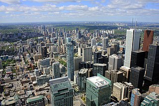
Midtown is one of four central business districts outside the city's downtown core of Toronto, Ontario, Canada. Located in the north of Old Toronto, its borders are roughly defined by St. Clair Avenue to the south and Eglinton Avenue or Lawrence Avenue to the north, Bayview Avenue to the east and Dufferin Street to the west. The central neighbourhood of the area is Yonge–Eglinton.
Royal York Road, historically known as Church Street or New Church Street, is a north-south arterial road in Toronto, Ontario, Canada. It is a concession road, 5 concessions (10 km) west of Yonge Street, and runs through many residential neighbourhoods, most notably Mimico and the Kingsway. It is classified as a "minor arterial" road by the city of Toronto.
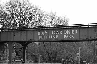
The Beltline Trail is a 9-kilometre (5.6 mi)-long cycling and walking rail trail in Toronto, Ontario, Canada. It consists of three sections, the York Beltline Trail west of Allen Road, the Kay Gardner Beltline Park from the Allen to Mount Pleasant Road, and the Ravine Beltline Trail south of Mount Pleasant Cemetery through the Moore Park Ravine. Built on the former right-of-way of the Toronto Belt Line Railway, the linear park passes through the neighbourhoods of Rosedale, Moore Park, Forest Hill, Chaplin Estates, and Fairbank.

Chaplin is an underground light rail transit (LRT) station under construction on Line 5 Eglinton, a new line that is part of the Toronto subway system. It will be located in the Forest Hill neighbourhood at the intersection of Chaplin Crescent and Eglinton Avenue, and is scheduled to open in 2022.

Yellow Creek is a partially-buried southeasterly tributary of the Don River in Toronto. It has also been known at different times as Silver Creek, Sylvan Creek, and Rosedale Brook. The former source of Yellow Creek begins near Sheppard West station in the Downsview neighbourhood. Most of the creek and its sources are buried underground in storm sewers until they emerge into Avoca Ravine in the Deer Park neighbourhood and continue their way to the Don River.

Mud Creek, is a mostly buried south-easterly tributary of the Don River in Toronto, Ontario, Canada. It has also been known at different times as Mount Pleasant Brook and Spring Valley Creek.