York Mills

Last updated

York Mills
Neighbourhood
York Mills Afternoon Traffic.jpg
Traffic in York Mills, east of Yonge.
York Mills map.PNG
Coordinates: 43°44′35″N79°24′24″W / 43.74306°N 79.40667°W / 43.74306; -79.40667
CountryFlag of Canada (Pantone).svg Canada
ProvinceFlag of Ontario.svg  Ontario
City Toronto
Municipality established1850 York Township
Changed municipality1922 North York from York Township
Changed municipality1998 Toronto from North York
Government
   MP Rob Oliphant (Don Valley West)
   MPP Stephanie Bowman (Don Valley West)
   Councillor Jaye Robinson (Ward 25 Don Valley West)

York Mills is a neighbourhood in Toronto, Ontario, Canada. It is centred around Yonge Street and York Mills Road located in the district of North York. In 2010, it encompassed the fourth and seventh most affluent postal codes in Canada. [1] It is recognized as a millionaires' mile, alongside the other Toronto neighbourhoods of The Bridlepath, Forest Hill, and Rosedale.

Contents

Part of the area is also known as Hoggs Hollow, named for James Hogg, a Scottish settler who settled in the area in 1824 and operated the mill on Yonge Street at the Don River north of the Town of York (now Toronto), by his sons John and William in 1856. Another portion is named St. Andrew-Windfields. St. Andrew-Windfields most famous resident was the popular Canadian Philanthropist E. P. Taylor who left Canada towards the latter years of his life and donated Parkland (now Windfields Park) and his mansion (now the Canadian Film Centre).

History

The area name is linked to saw and grist mills that dotted the Don River, which flows through York Mills. The Town of York Mills became part of the Township of North York.

View of the TTC's North Yonge Railways line in York Mills, 1936. Yonge Street, York Mills, North York Twp - Looking south to TTC North Yonge Railways Stop 1A at Mill Street, from north of the Jolly Miller Hotel at York Mills Station.jpg
View of the TTC's North Yonge Railways line in York Mills, 1936.

The area once linked by radial railways (Metropolitan line and the successor North Yonge Railways) and Highway 11, now can be reached via Highway 401, GO Transit, and Toronto Transit Commission buses and York Mills station on the Yonge-University Spadina subway line.

In 1953, York Mills, along with North York, was severed from York County, joining other municipalities to form the regional government of Metropolitan Toronto. The area was the site of a tragic accident on March 17, 1960, when five Italian construction workers on a water main project were killed in a tunnel fire. North York later became a borough, and then a city, and was merged with five other municipalities and a regional government to form the new "City of Toronto" in 1998.

Today, the area is home to luxury condos and high-end homes. Houses in York Mills are highly distinguishable and contribute greatly to the proclaimed affluence of the neighbourhood. 50% of occupied dwellings are single detached houses. Many have been rebuilt and customized to taste, with heavily renovated front yards. In between 2001 and 2006, property values have increased by 47.6%. [2] The second type of most occupied dwelling is apartments reaching five or more storeys, inhabited by 28% of the population. [3] The average price for condominiums in the area ranges from C$800,000 to C$3,000,000, while the average price of a detached home is just above C$4,000,000. [4] [5]

St. Andrew's Golf Course

From 1927 to 1950s the area south of Highway 401 and east of Yonge Street was home to St. Andrew's Golf Course. Designed by Stanley Thompson as an 18-hole course and later as 27 hole course, [6] it was sold to developers and now a residential area centred at Old Yonge Street and the Links Road. [7] The course hosted the Canadian Open in 1935 and 1936. [8]

Geography

The Toronto ravine system is prominently featured in the neighbourhood. Wilson Avenue To Hoggs Hollow.jpg
The Toronto ravine system is prominently featured in the neighbourhood.

From Yonge Street eastward, the roads slope upward but plateau as they reach Bayview Avenue. The natural environment is also highly integrated into the neighbourhood, with development seeming to build around it. The presence of greenery is a protected and distinguishable feature of York Mills.

Man-made environment

South of York Mills Road and Yonge Street sits the sub-neighbourhood of Hoggs Hollow. Houses in this residential area are embedded into the natural landscape, which ascends southward. The directional slope and other natural features serve as identifiable landmarks, edges, and paths, making this area highly legible in terms of a Lynchian analysis. The area has more community-oriented characteristics that make it distinct from the rest of York Mills. Most notably, residents manage a community board located in the centre of this sub-neighbourhood.

York Mills Centre is the tallest commercial building in the neighbourhood. York Mills Centre.jpg
York Mills Centre is the tallest commercial building in the neighbourhood.

As York Mills is a mainly residential neighbourhood, commercial activity occurs strictly at intersections of major arterials. At Yonge Street and York Mills Road, the tallest commercial building in the neighbourhood, York Mills Centre, holds large office and retail spaces, occupied most notably by the human resources services supplier, Randstad Interim. The York Mills Shopping Centre at the intersection of York Mills Road and Bayview Avenue, provides local groceries through the Metro supermarket, Shoppers Drug Mart, and local meat shop. It is set back from the roads by a large parking lot, consistent with the neighbourhoods dependency on automobiles.

Along York Mills Road in between major intersections, there are only single detached houses. The pedestrian paths are very close to roads. Residential area here leaves no space for any commercial opportunities, thus commercial nodes are only available at the intersection of major arterial roads.

There is very little public space. Properly maintained parks are often playgrounds for children. Actual parks do not properly serve the public as well with its lack of seating and walkways, which discourages overall usage. Free parking compared to the high hourly rates of the rest of Toronto points to space in York Mills as being an inexpensive commodity, yet there is very little space actually available for development. The current Official Plan does not provide for the anticipation of future development. [9]

Landmarks

Built in 1857, Miller Tavern is a local landmark in York Mills. Miller Tavern 2009.jpg
Built in 1857, Miller Tavern is a local landmark in York Mills.

Points of interest in York Mills:

Education

Two public school boards operate schools in York Mills, the English-first language Toronto District School Board (TDSB), and the French-first language Conseil scolaire Viamonde (CSV).

Ecole secondaire Etienne-Brule is one of two public secondary schools located in York Mills. Ecole secondaire Etienne-Brule.JPG
École secondaire Étienne-Brûlé is one of two public secondary schools located in York Mills.

TDSB also operates one secondary school in the neighbourhood, York Mills Collegiate Institute.

TDSB also operate six schools that provide primary education. They include:

CSV operates one secondary school in the neighbourhood, École secondaire Étienne-Brûlé. They do not operate an elementary school in the neighbourhood, with CSV elementary students residing in York Mills, attending schools in other neighbourhood.

The separate school boards for the City of Toronto, the English-based Toronto Catholic District School Board (TCDSB), and the French-based Conseil scolaire catholique MonAvenir (CSCM) also offer schooling to residents of York Mills, although they do not operate a school in the neighbourhood, with CSCM/TCDSB students attending schools situated in other neighbourhoods in Toronto.

Transportation

York Mills station is a subway station in York Mills. YorkMillsTTC NE entrance.JPG
York Mills station is a subway station in York Mills.

As a result of the man-made environment, large lots, and sprawled out nodes of commercial activity, the neighbourhood is highly reliant on the automobile for everyday activities, with approximately two thirds of the York Mills population using it as a primary mode of transportation . Having Highway 401 in such close proximity adds to the benefits of owning a car, as the degree of mobility to the rest of Toronto greatly increases. Public transit is reported to be less than a quarter of the population's primary method of commute. [10]

Deeper in the residential areas, pedestrian walkways are often only found on one side of the road. As much of the land surrounding the major arterials are claimed by private residences, there is no room to develop along pedestrian paths and make walking a more appealing option. The combined effect of this lack of appeal, poor infrastructural maintenance, and extended distance in between points of interests justify the populations' avoidance of walking, with a mere three percent of the population claim walking as their primary mode of commute. [11] York Mills is an example of a neighbourhood stuck within the cycle of auto-dependency.[ citation needed ]

Public transportation is provided by the Toronto Transit Commission (TTC). Services provided TTC include Line 1 Yonge–University of the Toronto subway, and several bus routes. The TTC operates one subway station in the neighbourhood, York Mills station. Oriole GO Station is also situated in the northeast of the neighbourhood, providing access to GO Transit's regional commuter railway.

Related Research Articles

<span class="mw-page-title-main">Bridle Path, Toronto</span> Neighbourhood in Toronto, Ontario, Canada

The Bridle Path is a residential neighbourhood in Toronto, Ontario, Canada. It is characterized by large multimillion-dollar mansions and two to four acre lot sizes. It makes up part of Bridle Path–Sunnybrook–York Mills. Often referred to as "Millionaires' Row", as of 2014 it is the most affluent neighbourhood in Canada, with an average household income of $936,137, as well as by property values with an average dwelling value of $2.24M.

<span class="mw-page-title-main">Agincourt, Toronto</span> Neighbourhood in Toronto, Ontario, Canada

Agincourt is a neighbourhood and former village in Toronto, Ontario, Canada. Agincourt is located in northeast Toronto, along Sheppard Avenue between Kennedy and Markham Roads. Before the creation of the "megacity" of Toronto in 1998, the area was part of Scarborough. It is officially recognized by the City of Toronto as occupying the neighbourhoods of Agincourt South–Malvern West and Agincourt North.

<span class="mw-page-title-main">Downsview</span> Neighbourhood in Toronto, Ontario, Canada

Downsview is a neighbourhood in the north end of Toronto, Ontario, Canada, located in the district of North York. The area takes its name from the Downs View farm established around 1842 near the present-day intersection of Keele Street and Wilson Avenue. It now extends beyond the intersection of Sheppard Avenue and Dufferin Street, though it is popularly seen as including the areas to the north right up to the Toronto city limit at Steeles Avenue. The area includes several large post-World War II subdivisions. Within the area is Downsview Airport, the former site of Canadian Forces Base Downsview, which has since been largely converted following the end of the Cold War into an urban park known as Downsview Park. The airport is still used as a manufacturing and testing facility for Bombardier Aerospace. As of the 2021 census, the Downsview-Roding-CFB neighbourhood was split into the two neighbourhoods of Downsview and Oakdale–Beverley Heights.

<span class="mw-page-title-main">Newtonbrook</span> Neighbourhood of Toronto

Newtonbrook is a neighbourhood in Toronto, Ontario, Canada. It is located in the area around Yonge Street and Finch Avenue in the district of North York between the east and west branches of the Don River. Officially, the area is divided into two neighbourhoods; Newtonbrook West and Newtonbrook East.

<span class="mw-page-title-main">Willowdale, Toronto</span> Neighbourhood in Toronto, Ontario, Canada

Willowdale is a neighbourhood in the city of Toronto, Ontario, Canada, located in the district of North York. It developed from three postal villages: Newtonbrook, Willowdale and Lansing.

<span class="mw-page-title-main">Henry Farm</span> Neighbourhood in Toronto, Ontario, Canada

Henry Farm is a neighbourhood in the City of Toronto, Ontario, Canada. It is located in the north central part of the city within the former city of North York.

<span class="mw-page-title-main">York Mills station</span> Toronto subway station

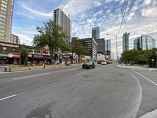
York Mills is a subway station on Line 1 Yonge–University in Toronto, Ontario, Canada. It is located at 4015 Yonge Street at the intersection of Wilson Avenue and York Mills Road in the neighbourhood of Hoggs Hollow.

<span class="mw-page-title-main">Richview, Toronto</span> Neighbourhood in Toronto, Ontario, Canada

Richview, formally known as Willowridge-Martingrove-Richview, is a neighbourhood in the city of Toronto, Ontario, Canada. It is bounded on the west by Highway 401 and on the north by the highway and by Dixon Road, Royal York Road on the east, and Eglinton Avenue West along the south. Richview was originally established as a postal village within the then-agricultural Etobicoke Township, which later became the suburb of Etobicoke.

<span class="mw-page-title-main">Yorkdale–Glen Park</span> Neighbourhood in Toronto, Ontario, Canada

Yorkdale–Glen Park is a neighbourhood in the city of Toronto, Ontario, Canada, located in the former suburb of North York. It is bounded by Highway 401 to the north, Allen Road to the east, a line south of Stayner Avenue to the south, and the CNR tracks to the west.

<span class="mw-page-title-main">Lawrence Manor</span> Neighbourhood in Toronto, Ontario, Canada

Lawrence Manor is a neighbourhood in the city of Toronto, Ontario, Canada. This neighbourhood is bounded by Bathurst Street on the east, Highway 401 to the north, the Allen to the west, and Lawrence Avenue to the south. The western side of the area borders along Bathurst Heights and the large public housing project.

<span class="mw-page-title-main">Clanton Park, Toronto</span> Neighbourhood in Toronto, Ontario, Canada

Clanton Park is a neighbourhood in Toronto, Ontario, Canada. Located in the district of North York, it is part of federal and provincial electoral district York Centre, and Toronto electoral wards 9: York Centre (West) and 10: York Centre (East). In 2016, it had a population of 16,472, a 12.7% rise from 2011.

<span class="mw-page-title-main">Pleasant View, Toronto</span> Neighbourhood in Toronto, Ontario, Canada

Pleasant View is a neighbourhood in the city of Toronto, Ontario, Canada that is located in the district of North York at the northern end of the city. It is bordered by Victoria Park to the East, Sheppard Avenue to the South, Highway 404 to the west and the Finch hydro corridor to the north. The neighbourhood is home to several high-rise apartment and condominium buildings, such as The Clippers.

<span class="mw-page-title-main">Hillcrest Village</span> Neighbourhood in Toronto, Ontario, Canada

Hillcrest Village is a neighbourhood located in Toronto, Ontario, Canada. It is located in the northern district of North York. It is bordered by Finch to the South, Leslie Street to the West, Steeles to the North and Victoria Park to the East. Both neighbourhoods share the Don Valley as a point of reference in the Eastern border of the neighbourhoods.

<span class="mw-page-title-main">Steeles, Toronto</span> Neighbourhood in Toronto, Ontario, Canada

Steeles is a suburban neighbourhood in Toronto, Ontario, Canada. Steeles is located in the north-eastern part of Toronto in the former suburb of Scarborough. To the north is bordered by Steeles Avenue East, to the east by Kennedy Road, to the south by a hydro-electric transmission line and to the west by Victoria Park Avenue.

<span class="mw-page-title-main">Clairlea</span> Neighbourhood in Toronto, Ontario, Canada

Clairlea is a safe, quiet, middle to upper-middle income neighbourhood in Toronto, Ontario, Canada that features well treed streets and detached homes with large backyards. The neighbourhood is located in east Toronto just east of Victoria Park Avenue.

<span class="mw-page-title-main">Eglinton East</span> Neighbourhood in Toronto, Ontario, Canada

Eglinton East, historically known as Knob Hill, is a residential and commercial neighbourhood in Toronto, Ontario, Canada. It is bounded by Stansbury Crescent, Citadel Drive, and West Highland Creek to the north, Midland Avenue to the west, the CNR rail line, Brimley Road, and Eglinton Avenue to the south, and Bellamy Road North to the east.

<span class="mw-page-title-main">The Queensway–Humber Bay</span> Neighbourhood in Toronto, Ontario, Canada

The Queensway–Humber Bay, known officially as Stonegate–Queensway, is a neighbourhood in the southwest of Toronto, Ontario, Canada. It is located in the southeast area of the former City of Etobicoke.

<span class="mw-page-title-main">Morningside Heights, Toronto</span> Neighbourhood in Toronto, Ontario, Canada

Morningside Heights is a residential neighbourhood in Toronto, Ontario, Canada. It is located in the northeast corner of the city, in the district of Scarborough, just north of the neighbourhood of Malvern and west of Rouge Park and the Rouge. The subdivision, comprising approximately 750 acres (3.0 km2), was one of the last large tracts of undeveloped land within the City of Toronto, located between Finch Avenue East and Steeles Avenue East, from Tapscott Road to the Rouge River.

<span class="mw-page-title-main">Upper Beaches</span> Neighbourhood in Toronto, Ontario, Canada

The Upper Beaches is a neighbourhood in Toronto, Ontario, Canada. It is directly north of the Beaches area. It stretches from Coxwell Avenue in the west to Victoria Park in the east. The southern border is Kingston Road, while the northern boundary is generally considered to be the Canadian National Railway tracks between Gerrard Street and Danforth Avenue. The western part of the area was originally called Norway, and the larger area was once part of the Town of East Toronto. The name "Upper Beaches" was first used by developers and real estate agents around the period of 2001 to 2003 for the selling of houses on redeveloped land in the area, and was used as a marketing tag to attract buyers. The area was never considered part of the Beaches neighbourhood but was close to it. The city's current name for this area is East End Danforth, though that is rarely used. The city also includes the buildings along and just north of Danforth Avenue in the neighbourhood. The western portion between Woodbine Avenue and Coxwell is referred to by the city as Woodbine Corridor.

<span class="mw-page-title-main">Armour Heights</span> Neighbourhood in Toronto, Ontario, Canada

Armour Heights is a neighbourhood in Toronto, Ontario, Canada, in the district of North York. It is bounded by Wilson Avenue to the south, Bathurst Street to the west, and the west branch of the Don River to the north and east. Highway 401 cuts through the centre of the neighbourhood.

References

  1. Canada's Richest Postal Codes "Richest Postal Codes 2011 | CanadianBusiness.com". Archived from the original on November 27, 2012. Retrieved November 17, 2012.
  2. Statistics Canada Census, 2006
  3. Statistics Canada Census, 2006
  4. Toronto Neighbourhood Guide. "Toronto Neighbourhoods Real Estate Update 2012 - North York". Maple Tree Publishing. Retrieved 9 October 2013.
  5. Toronto Neighbourhood Guide. "Homes in York Mills". Maple Tree Publishing. Retrieved 9 October 2013.
  6. "St. Andrews Golf Club — Stanley Thompson Society".
  7. "St. Andrews Golf Course".
  8. "St. Andrews Estates and Golf Course, York Mills, Ontario by J.I.B. Jones" (PDF). www.golfhistoricalsociety.org.
  9. "Toronto Official Plan"
  10. Statistics Canada Census, 2006
  11. Statistics Canada Census, 2006

Commons-logo.svg Media related to York Mills at Wikimedia Commons