
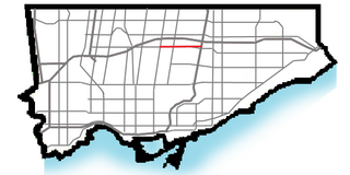
Yonge–Eglinton is a neighbourhood in Toronto, Ontario, Canada, at the intersection of Yonge Street and Eglinton Avenue. It is central to the area of Midtown Toronto, one of four central business districts outside Downtown Toronto. The City of Toronto defines its boundaries as Briar Hill Avenue to the north, Yonge Street to the east, Frobisher Avenue and a line in that direction west to Elmsthorpe Avenue, then north to Eglinton Avenue, east to Avenue Road and north to Briar Hill.

North Toronto is a former town and informal district located in the northern part of the Old Toronto district in Toronto, Ontario, Canada. Currently occupying a geographically central location within the city of Toronto, the Town of North Toronto was incorporated in 1890, when much of the area was still farmland, and annexed by Toronto in 1912. The name is still used to refer to the area in general, although Yonge–Eglinton and Midtown Toronto are officially used.

Deer Park is a neighbourhood in Toronto, Ontario, Canada. It is centered on the intersection of Yonge Street and St. Clair Avenue and its boundaries are the Vale of Avoca section of Rosedale ravine in the east, Farnham Avenue and Jackes Avenue in the south, Avenue Road and Oriole Parkway in the west, the Beltline Trail in the north on the west side of Yonge Street, and Glen Elm Avenue in the north on the east side of Yonge Street. For the purposes of social policy analysis and research, the Toronto government’s Social Development & Administration division includes Deer Park within the City of Toronto's official "Rosedale-Moore Park" and "Yonge-St.Clair" neighbourhood profiles. The neighbourhood is in Ward 22, represented by Councillor Josh Matlow at Toronto City Council.

Lawrence Park is a neighbourhood in Toronto, Ontario, Canada. It is bordered by Yonge Street to the west and Bayview Avenue to the east, and from Blythwood Ravine on the south to Lawrence Avenue on the north. Lawrence Park was one of Toronto's first planned garden suburbs. Begun in the early part of the 20th century, it did not fully develop until after the Second World War. It was ranked the wealthiest neighbourhood in all of Canada in 2011.
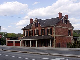
Hoggs Hollow is a residential neighbourhood in Toronto, Ontario, Canada. It is located to the south of York Mills Road, east of Yonge Street, and the western branch of the upper Don River flows through it.

Lawrence Heights is a neighbourhood in Toronto, Ontario, Canada. It is located north-west of central Toronto, in the district of North York. The neighbourhood is roughly bounded by Lawrence Avenue to the south, Yorkdale Road to the north, Varna Drive to the east and Dufferin Street to the west. It is part of the greater Yorkdale-Glen Park official Toronto neighbourhood.

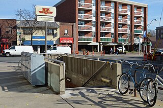
York Mills is a subway station on Line 1 Yonge–University in Toronto, Ontario, Canada. It is located at 4015 Yonge Street at the intersection of Wilson Avenue and York Mills Road in the neighbourhood of Hoggs Hollow.
The Toronto Suburban Railway was a Canadian electric railway operator with local routes in west Toronto, and a radial (interurban) route to Guelph.
The Metropolitan line in the Toronto area, operated by the Metropolitan Street Railway, started out as a local horsecar line and transformed itself into an electric radial line extending to Lake Simcoe, following an old stage coach route. In 1904, the railway was acquired by the Toronto and York Radial Railway (T&YRR) and became the T&YRR Metropolitan Division. In 1922, the City of Toronto acquired the T&YRR and contracted Ontario Hydro to manage the four T&YRR lines including the Metropolitan. In 1927, the TTC took over the operation of the Metropolitan Line to Sutton, and renamed it the Lake Simcoe line. In 1930, the TTC closed the Metropolitan Line but shortly reopened the portion between Glen Echo and Richmond Hill operating it as the North Yonge Railways until 1948.

The North Yonge Railways was a radial railway line operated by the Toronto Transportation Commission from 1930 to 1948 between Glen Echo (Toronto) and Richmond Hill. The line was created by reopening the southern portion of the TTC's Lake Simcoe radial line that had closed in 1930.

Lawrence Avenue is a major east–west thoroughfare in Toronto, Ontario, Canada. It is divided into east and west portions by Yonge Street, the dividing line of east–west streets in Toronto.
York Mills Road is an east-west route in Toronto, Ontario, Canada named for the historic village of York Mills that was located on the hill immediately north of today's intersection of York Mills Road and Yonge Street. The village of York Mills is distinguished from the 1920s subdivision to the south known as Hoggs Hollow. "York" refers to York Township and "Mills" refers to the gristmills and sawmills that once operated (1804–1926) in the valley through which the Don River runs.
Gray Coach was a Canadian inter-city bus line based in Toronto, Ontario, from 1927 to 1992. It was founded and initially owned by the Toronto Transportation Commission, until sold to Stagecoach in 1990. In 1992 the business was sold to Greyhound Canada and the brand was retired.
Bedford Park is a neighbourhood just outside the downtown core of Toronto. It borders Lawrence Park which was ranked Canada's wealthiest neighbourhood in 2011. The City of Toronto's neighbourhood definitions places most of Bedford Park, including Bedford Park Avenue in the Lawrence Park North Planning Neighbourood and the remaining western and northern portions of Bedford Park within a larger neighbourhood, called Bedford Park-Nortown. The border of this larger area extend to Bathurst Street on the west, Highway 401 to the north, Hillhurst Boulevard to the south, and zigzags from northeast to southwest along Yonge Street and Avenue Road.

Yorkdale–Glen Park is a neighbourhood in the city of Toronto, Ontario, Canada, located in the former suburb of North York. It is bounded by Highway 401 to the north, Allen Road to the east, a line south of Stayner Avenue to the south, and the CNR tracks to the west.

Turning loops of the Toronto streetcar system serve as termini and turnback points for streetcar routes in Toronto, Ontario, Canada. The single-ended streetcars require track loops in order to reverse direction. Besides short off-street track loops these can also be larger interchange points, having shelters and driver facilities, or be part of a subway station structure for convenient passenger interchange.

Mount Pleasant Road is a major arterial thoroughfare in Toronto, Ontario, Canada. The street extends from Jarvis Street south of Bloor Street north to Glen Echo Drive. The road is unique as one of the few arterial roads in Toronto to be created after the development of the suburbs which it passes through. These include the wealthy Rosedale, Moore Park and Lawrence Park neighbourhoods. The road also passes through the centre of Mount Pleasant Cemetery, after which it takes its name.
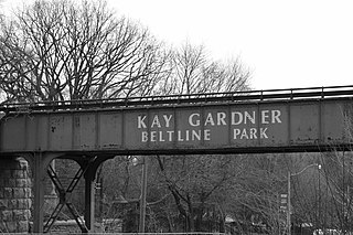
The Beltline Trail is a 9-kilometre (5.6 mi)-long cycling and walking rail trail in Toronto, Ontario, Canada. It consists of three sections, the York Beltline Trail west of Allen Road, the Kay Gardner Beltline Park from the Allen to Mount Pleasant Road, and the Ravine Beltline Trail south of Mount Pleasant Cemetery through the Moore Park Ravine. Built on the former right-of-way of the Toronto Belt Line Railway, the linear park passes through the neighbourhoods of Rosedale, Moore Park, Forest Hill, Chaplin Estates, and Fairbank.

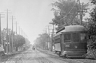
Beginning operation in 1861, the Yonge streetcar line was the first streetcar line in Toronto and the first in Canada. It started off as a horsecar line and closed in 1954 operating two-unit trains of Peter Witt motors pulling a trailer. Under the Toronto Transportation Commission, the Yonge line was the busiest and most congested streetcar line in the city leading to its replacement in 1954 by the Yonge Subway line, also Toronto's first and the first in Canada.