
Etobicoke is an administrative district and former city within Toronto, Ontario, Canada. Comprising the city's west-end, Etobicoke is bordered on the south by Lake Ontario, on the east by the Humber River, on the west by Etobicoke Creek, the cities of Brampton, and Mississauga, the Toronto Pearson International Airport, and on the north by the city of Vaughan at Steeles Avenue West.
Port Union, also known as Centennial Scarborough is a neighbourhood in Toronto, Ontario, Canada. It is located in the south-east corner of Toronto, within the former suburb of Scarborough. The neighbourhood is bounded by Kingston Road to the north, Port Union Road to the east, the Lake Ontario shoreline to the south, and Highland Creek to the west.

Malvern is a neighbourhood in the city of Toronto, Ontario, Canada, with a population of 44,315. It is located in the northeast corner of the city.

Scarborough Village is a neighbourhood in Toronto, Ontario, Canada, located in the Scarborough district. It was one of the earliest settlements in the former township of Scarborough with the distinction of being the site of the township's first post office. Today, the neighbourhood is composed of private and public housing, apartment complexes, schools, a few condominiums, and strip mall plazas. The neighbourhood lies along the Scarborough Bluffs escarpment.

Henry Farm is a neighbourhood in the City of Toronto, Ontario, Canada. It is located in the north central part of the city within the former city of North York.
The Eglinton West line was a proposed east–west subway line in Toronto, Ontario, Canada, whose construction began in 1994 but was cancelled in 1995. It was to start from the existing Eglinton West station on the Toronto Transit Commission's Yonge–University–Spadina line, travel underneath Eglinton Avenue West, and terminate at Black Creek Drive in its initial phase.

Kipling Avenue is a street in the cities of Toronto and Vaughan in Ontario, Canada. It is a concession road, 6 concessions (12 km) west from Yonge Street, and is a major north–south arterial road. It consists of three separate sections, with total combined length of 26.4 km. (16.4 mi.).

Smithfield is a neighbourhood and former village in Toronto, Ontario, Canada. Some new residents of Toronto and new immigrants to Canada are attracted to this neighbourhood, mainly because there is a large amount of affordable public housing. It is named after the former village of Smithfield that was located at the intersection of Albion Road and Martin Grove Road. The neighbourhood is located north of the west branch of the Humber River and west of Kipling Avenue.

Kingsview Village is a neighbourhood in the city of Toronto, Ontario, Canada. It is located in the north end of the former suburb of Etobicoke, and is bounded on the north by Highway 401, on the east by the Humber River and St. Phillips Road, on the south by Dixon Road. It is relatively close to Toronto Pearson International Airport in Mississauga, and TTC bus routes connect it to the rest of the city.
Humber Valley Village is a neighbourhood located in Toronto, Ontario, Canada. It is within the former suburb of Etobicoke and includes some of the most expensive real estate in the metropolitan west end. The boundaries are from Dundas Street on the south to Islington Avenue to the west, Eglinton Avenue to the north, and the Humber River in the east. The neighbourhood is in the political riding of Etobicoke Centre.

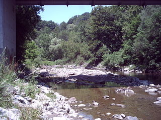
Humber Heights-Westmount, also known as Humbervale, is a neighbourhood in Toronto, Ontario, Canada. The neighbourhood is bounded by the west bank of the Humber River, west to Royal York Road and south to Eglinton Avenue West. The Humber Creek divides the area into the northern 'Humber Heights' and the southern 'Westmount' centred along Scarlett Road and La Rose Avenue.

Islington-City Centre West is a commercial and residential neighbourhood in Toronto, Ontario, Canada. One of four central business districts outside Downtown Toronto, it is bounded by Rathburn Road to the north, Islington Avenue to the east, Bloor Street to the south, Mimico Creek to the west.

Lawrence Manor is a neighbourhood in the city of Toronto, Ontario, Canada. This neighbourhood is bounded by Bathurst Street on the east, Highway 401 to the north, the Allen to the west, and Lawrence Avenue to the south. The western side of the area borders along Bathurst Heights and the large public housing project.

For the settlement established by former slaves in Guyana known as Victoria Village see Victoria, Guyana

Don Valley Village is a neighbourhood in the city of Toronto, Ontario, Canada. It is located in the former suburb of North York. Located north of Highway 401 and bisected by Don Mills Road, it is bounded by Sheppard Avenue to the south, Leslie Street to the west, Finch Avenue to the north and Highway 404 to the east. Like the nearby Don River Valley, the neighbourhood has hill and dale topography.

Eglinton East, historically known as Knob Hill, is a residential and commercial neighbourhood in Toronto, Ontario, Canada. It is bounded by Stansbury Crescent, Citadel Drive, and West Highland Creek to the north, Midland Avenue to the west, the CNR rail line, Brimley Road, and Eglinton Avenue to the south, and Bellamy Road North to the east.

The Queensway–Humber Bay, known officially as Stonegate–Queensway, is a neighbourhood in the southwest of Toronto, Ontario, Canada. It is located in the southeast area of the former City of Etobicoke.
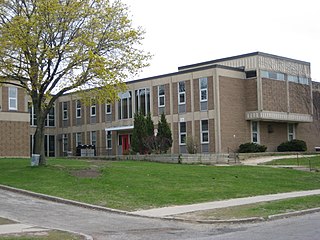
Scarlett Heights Entrepreneurial Academy (SHEA), formerly known as Scarlett Heights Collegiate Institute (SHCI) is a Toronto District School Board facility that was originally operated as a secondary school, opened in 1963, and whose curriculum was broadened through a Student Leadership Development Program. This program extends the base curriculum. Although the TDSB closed the school in June 2018 due to low enrolment, the school facility was used to temporarily accommodate students from York Memorial Collegiate Institute. It is now vacant.

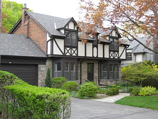
Princess Gardens is a neighbourhood in Toronto, Ontario, Canada. It is located in the western area of Toronto that was formerly the City of Etobicoke. Its boundaries are Eglinton Avenue to the north, Martin Grove to the west, Islington to the east, and Rathburn Road to the south. The southeastern part of this area is the separate neighbourhood of Thorncrest Village. The neighbourhood is divided into two areas: The portion east of Kipling Road is known as Princess Anne Manor, while the portion west of Kipling is Princess Margaret Gardens. They are named after Princess Anne, Princess Royal, and Princess Margaret, Countess of Snowdon, the daughter and sister of the late Queen Elizabeth II respectively. Both Princesses visited the Gardens and opened up Princess Margaret Public School during its opening ceremony. The southwestern part of the neighbourhood is also sometimes known as Glen Agar. Princess Gardens has some of the highest income Canadians in the Greater Toronto Area according to a 2016 census, at an average of $222,218 per year.

Maple Leaf is a neighbourhood in the city of Toronto, Ontario, Canada. It is located in the southwest of the North York district. Its approximate borders are Lawrence Avenue to the south, Culford Road to the west, Highway 401 to the north, and the CNR rail lines east of Keele Street to the east.


