High Park North

Last updated

High Park North
Neighbourhood
High Park North 2023.jpg
Aerial view of apartments in High Park North from Bloor Street
High Park North map.png
Neighbourhood map of High Park North
Toronto map.png
Red pog.svg
Location within Toronto
Coordinates: 43°39′22″N79°28′30″W / 43.656°N 79.475°W / 43.656; -79.475
CountryFlag of Canada (Pantone).svg  Canada
ProvinceFlag of Ontario.svg  Ontario
City Toronto
CommunityToronto & East York
Established1883 (Subdivision)
Changed Municipality1887 West Toronto from York
1909 Toronto (former) from West Toronto
1998 Toronto from Toronto (former)
Government
   MP Arif Virani (Parkdale—High Park)
   MPP Bhutila Karpoche (Parkdale—High Park)
   Councillor Gord Perks (Ward 4 Parkdale—High Park)

High Park North, or often simply High Park, after the park, is a neighbourhood in Toronto, Ontario, Canada. It is bounded on the south by Bloor Street, on the west by Runnymede Road, on the north by Annette Street, Quebec Avenue and Humberside Avenue, and on the east by the GO Transit Weston Subdivision rail tracks (formerly owned by Canadian National Railway). It is located in the Parkdale—High Park provincial and federal electoral districts. The area east of Keele Street is also known informally as the "West Bend" neighbourhood.

Contents

Character

A TTC streetcar leaving Dundas West Station along Edna Avenue. TTC 504 King ALRV 4223 leaves Dundas West Station on October 11, 2013.JPG
A TTC streetcar leaving Dundas West Station along Edna Avenue.

High Park North is mainly residential, containing many semi-detached homes built in the early 20th century. North of High Park, the neighbourhood has several high-rise apartment buildings, built after the construction of the Bloor-Danforth subway.

Bloor Street is the main east-west thoroughfare. It is a four-lane road and is mostly commercial with storefront-type businesses that have residential second and third storeys. North-south roads include Keele Street and Dundas Street. Both are primarily residential within the neighbourhood.

The oldest residential houses in High Park North were built in the late 1800s and early 1900s and are mostly Victorian, Edwardian and Tudor-style. The houses are typically two- and three-storey detached brick homes. Many homes have leaded and stained glass windows, wood trim, French doors, hardwood doors, and fireplaces. [1]

Just north of the park is a district of high-rise apartment buildings, dating from the 1960s and 1970s. These are primarily located on Gothic, High Park, and Quebec Avenues. [1]

History

High Park North exists within the traditional territories of the Missisauga Anishinaabeg. The area however has also been home to Huron-Wendat and Haudenosaunee nations throughout history. High Park North exists on part of an old trading trail that led down toward the lake. This trail is the namesake for Indian Road, Indian Road Crescent, and Indian Grove.

High Park North falls entirely within the boundaries of the town of Toronto Junction, which was purchased from the Keele estate in 1882 by Daniel Clendenan who subdivided the farm and racetrack for a residential district (now called High Park North) to serve the Junction commercial district. As Bloor Street was still an uneven and a mostly undeveloped street, early housing in the area was concentrated to the north and east, where it was easier to access the stores and industry along Dundas Street. High Park Avenue in particular was the site of many early homes of the Junction wealthy, as was modern Evelyn Crescent; many of these houses are still standing. High Park North emerged as a neighbourhood once Bloor Street was widened and evened out following World War I, when most of the residential homes which still exist today were built.

20th Century

In 1915, Bloor Street was the site of a major public works at the north-west corner of High Park. The street, west of High Park Avenue, was crossed by creeks that emptied into Grenadier Pond. The creek banks were steep, making the roadway treacherous and difficult for traffic. A rail trestle was built to cross the gap at a level of 60 feet. The rails were used for rail cars to dump soil around the trestle. The trestle was completely buried and the present Bloor Street roadway built on top. [2] Existing north-south roadways connecting to Bloor Street were raised to meet the new level of Bloor Street and this facilitated the development of the neighbourhood. The first building in Canada designed by a Canadian trained female architect was constructed in the neighbourhood during this period. This landmark building by Jean Hall is a 1925 fourplex located at 63 Jerome Street. [3]

View of the area from Keele station, 1968. Concurrent with the arrival of the subway line in the 1960s, there were many residences razed in order to build apartment buildings. Keele TTC bus loop in 1968.jpg
View of the area from Keele station, 1968. Concurrent with the arrival of the subway line in the 1960s, there were many residences razed in order to build apartment buildings.

In the 1960s, the area directly north of High Park was the site of 'block-busting' development. After the construction of the Bloor-Danforth subway line in the 1960s, the nearby residences on High Park Avenue, Quebec Avenue and Gothic Avenue were bought up by developers, razed and large apartment buildings were built. The area from north of the subway line to Glenlake Avenue is now almost entirely high-rise towers. At the time, the City government was very much pro-development, and there were no local ratepayer/community associations as is seen today. Local City alderman Ben Grys, along with his wife, owned properties on Gothic Avenue and voted to approve the apartment project on the site before his family's land holdings were revealed by John Sewell through a search of local property tax rolls. Under vague conflict-of-interest guidelines, Grys continued as alderman until he was defeated in the following municipal election. Grys sued Sewell over Sewell's attempt to remove him but eventually withdrew his case when it became clear that Sewell would get access to further information about his business dealings. By the 1970s, local residents formed associations in harmony with new reform Council members, partly to fight the block-busting north of High Park.

21st Century

The desirability of living close to High Park and the subway keeps developers operating in the neighbourhood, although not on the scale of the past. In the first decade of the 2000s, a condominium development was built on the site of a former gas station on the south side of Bloor Street, overlooking High Park on the landfill of the former bridge over Wendigo Creek.

One block east of High Park Avenue, between Pacific and Oakmount, a block of Edwardian-era homes was purchased for demolition. The area is the site of a condominium development overlooking High Park. A tenant of one of the homes remained while the other homes became vacant and boarded up until eviction in 2010, much like the block-busting of the 1960s and 1970s. This is the first block of older homes directly on Bloor Street, facing High Park, to be demolished for apartment building.

Demographics

The High Park neighbourhood has a population of 22162. [4]

Generation Status

Between the years of 2006 and 2011, there were changes in the generation status of the population aged 15 years and older. In 2006, 62% of the total population were 1st generation, which is higher than that of 2011, which was 59%. The number of people who were 2nd or 3rd generation increased since 2006 in 2011. In 2006, 16% were 2nd generation, and 22% were 3rd generation. In 2011, 17% were 2nd generation and 24% were 3rd generation. The 2011 GNR was 32.6%. [4]

Education

The Toronto District School Board (TDSB) is an English secular public school board that serves the City of Toronto. The school board operates a number of institutions that provides primary and secondary education in the area including:

Humberside Collegiate Institute is a secular public secondary school operated by the Toronto District School Board. Humberside Collegiate Institute.JPG
Humberside Collegiate Institute is a secular public secondary school operated by the Toronto District School Board.

The Toronto District Catholic School Board (TDCSB) is a public English separate school board that serves the City of Toronto. The school board operates a number of institutions that provides primary and secondary education in the area including:

St. Cecilia School was established by Father Joseph McCann, a priest at St. Helen's Church, who purchased land on Edwin Avenue in November 1887 to establish a new Catholic church and school. Originally the parish was to be named after St. Charles. According to historical records, however, the first school—a small wooden structure—was named St.Mary's. In 1890 the school was replaced with a brick building and renamed St.Cecilia's. Legend has it that St. Cecilia, the patron saint of sacred music, was chosen as the new name because the Heintzman Piano factory stood in view, across the railway tracks, from the school. The present St. Cecilia's Church, at the corner of Annette Street and Pacific Avenue, was opened in 1909, replacing a smaller structure first occupied in 1895. Father Eugene Gallagher was the pastor.

View of Runnymede branch of the Toronto Public Library, located in the southwest edge of High Park North. Runnymede TPL.jpg
View of Runnymede branch of the Toronto Public Library, located in the southwest edge of High Park North.

The present St. Cecilia Catholic School at the corner of Annette Street and Evelyn Avenue opened in 1914 with additions in 1918, 1954 and 1964. The school's first teachers and administrators were the Loretto Nuns, who lived in the former Heintzman family residence at Annette and Laws Streets, providing another musical connection with St. Cecilia.

Toronto Public Library

The Runnymede Branch of the Toronto Public Library, housed in a renovated heritage building built in 1930, is located within High Park North at Bloor Street West and Glendonwynne Road. The Annette branch of the TPL is located to the northeast of the neighbourhood at Annette and Medland.

Transportation

High Park North is served by three subway stations of the TTC's Bloor-Danforth line. High Park North Subway Crossing.jpg
High Park North is served by three subway stations of the TTC's Bloor-Danforth line.

The neighbourhood is served by the Dundas West, Keele and High Park stations of the Bloor-Danforth TTC subway line. The TTC operates local buses out of each station.

See also

Related Research Articles

<span class="mw-page-title-main">The Kingsway, Toronto</span> Neighbourhood in Toronto, Ontario, Canada

The Kingsway is a residential neighbourhood in Toronto, Ontario, Canada. It is bounded by Bloor Street to the south, Dundas Street to the north, the Mimico Creek to the west and the Humber River to the east. The neighbourhood was officially known as Kingsway Park, which later became replaced by its nickname, The Kingsway. For planning purposes, the neighbourhood is known by the City of Toronto as "Kingsway South" to differentiate it from a more recent extension of The Kingsway north of Dundas Street. "Kingsway South" is not used by residents, due to confusion with the South Kingsway, a street located east of the Humber River and extending south from Bloor Street.

<span class="mw-page-title-main">Bendale</span> Neighbourhood in Toronto, Ontario, Canada

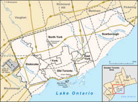
Bendale, also called Cedarbrae and Midland Park, is a residential neighbourhood in the eastern part of Toronto, Ontario, Canada. It is located in the former suburb of Scarborough. It is centred on the intersection of Lawrence Avenue East and Brimley Road. Its boundaries, as defined by the City, are Midland Avenue from Lawrence, north to Highway 401, east to McCowan, south to Lawrence, east to West Highland Creek, south-west along West Highland Creek, then follow several side streets parallel to the Creek, north to Midland Avenue. The area north of Ellesmere is typically considered the Scarborough City Centre district, and is not considered in this neighbourhood article.

<span class="mw-page-title-main">The Junction</span> Neighbourhood in Toronto, Ontario, Canada

The Junction is a neighbourhood in Toronto, Ontario, Canada, that is near the West Toronto Diamond, a junction of four railway lines in the area. The neighbourhood was previously an independent city called West Toronto, that was also its own federal electoral district until amalgamating with the city of Toronto in 1909. The main intersection of the area is Dundas Street West and Keele Street. The Stockyards is the northeastern quadrant of the neighbourhood.

<span class="mw-page-title-main">Little Italy, Toronto</span> Neighbourhood in Toronto, Ontario, Canada

Little Italy, sometimes referred to as College Street West, is a district in Toronto, Ontario, Canada. It is known for its Italian Canadian restaurants and businesses. There is also a significant Latin-Canadian and Portuguese-Canadian community in the area. The district is centred on a restaurant/bar/shopping strip along College Street, centred on College Street, imprecisely between Harbord Street and Dundas Street, and spreading out east and west between Bathurst Street and Ossington Avenue. It is contained within the larger city-recognized neighbourhood of Palmerston-Little Italy.

<span class="mw-page-title-main">Riverdale, Toronto</span> Neighbourhood in Toronto, Ontario, Canada

Riverdale is a large neighbourhood in Toronto, Ontario, Canada. It is bounded by the Don River Valley to the west, Danforth Avenue and Greektown to the north, Jones Avenue, the CN/GO tracks, Leslieville to the east, and Lake Shore Boulevard to the south.

<span class="mw-page-title-main">Downsview</span> Neighbourhood in Toronto, Ontario, Canada

Downsview is a neighbourhood in the north end of Toronto, Ontario, Canada, located in the district of North York. The area takes its name from the Downs View farm established around 1842 near the present-day intersection of Keele Street and Wilson Avenue. It now extends beyond the intersection of Sheppard Avenue and Dufferin Street, though it is popularly seen as including the areas to the north right up to the Toronto city limit at Steeles Avenue. The area includes several large post-World War II subdivisions. Within the area is Downsview Airport, the former site of Canadian Forces Base Downsview, which has since been largely converted following the end of the Cold War into an urban park known as Downsview Park. The airport is still used as a manufacturing and testing facility for Bombardier Aerospace. As of the 2021 census, the Downsview-Roding-CFB neighbourhood was split into the two neighbourhoods of Downsview and Oakdale–Beverley Heights.

<span class="mw-page-title-main">Roncesvalles, Toronto</span> Neighbourhood in Toronto, Ontario, Canada

Roncesvalles is a neighbourhood in the city of Toronto, Ontario, Canada, centred on Roncesvalles Avenue, a north–south street leading from the intersection of King and Queen Streets to the south, north to Dundas Street West, a distance of roughly 1.7 kilometres. It is located east of High Park, north of Lake Ontario, in the Parkdale–High Park provincial and federal ridings and the municipal Ward 4. Its informal boundaries are High Park to the west, Bloor Street West to the north, Lake Ontario/Queen Street West to the south and Lansdowne Avenue/rail corridor to the east. Originally known as "Howard Park", most of this area was formerly within the boundaries of Parkdale and Brockton villages and was annexed into Toronto in the 1880s.

<span class="mw-page-title-main">Lawrence Park, Toronto</span> Neighbourhood in Toronto, Ontario, Canada

Lawrence Park is a neighbourhood in Toronto, Ontario, Canada. It is bordered by Yonge Street to the west and Bayview Avenue to the east, and from Blythwood Ravine on the south to Lawrence Avenue on the north. Lawrence Park was one of Toronto's first planned garden suburbs. Begun in the early part of the 20th century, it did not fully develop until after the Second World War. It was ranked the wealthiest neighbourhood in all of Canada in 2011.

<span class="mw-page-title-main">Newtonbrook</span> Neighbourhood of Toronto

Newtonbrook is a neighbourhood in Toronto, Ontario, Canada. It is located in the area around Yonge Street and Finch Avenue in the district of North York between the east and west branches of the Don River. Officially, the area is divided into two neighbourhoods; Newtonbrook West and Newtonbrook East.

<span class="mw-page-title-main">Malvern, Toronto</span> Neighbourhood in Toronto, Ontario, Canada

Malvern is a neighbourhood in the city of Toronto, Ontario, Canada, with a population of 44,315. It is located in the northeast corner of the city.

<span class="mw-page-title-main">West Hill, Toronto</span> Neighbourhood in Toronto, Ontario, Canada

West Hill is a neighbourhood in Toronto, Ontario, Canada. It is located in the eastern end of the city, in the former suburb of Scarborough. It is roughly bounded by Scarborough Golf Club Road and a branch of Highland Creek on the west, the CNR railway tracks and Lake Ontario on the south, and Highland Creek on the north-east. The name comes from its elevated position on the west side of Highland Creek, a deep glacial ravine.

<span class="mw-page-title-main">Willowdale, Toronto</span> Neighbourhood in Toronto, Ontario, Canada

Willowdale is a neighbourhood in the city of Toronto, Ontario, Canada, located in the district of North York. It developed from three postal villages: Newtonbrook, Willowdale and Lansing.

<span class="mw-page-title-main">Brockton Village</span> Neighbourhood in Toronto, Ontario, Canada

Brockton Village is a former town, and now the name of a neighbourhood, in Toronto, Ontario, Canada. It comprises a section of the old Town of Brockton which was annexed by the City of Toronto in 1884.

<span class="mw-page-title-main">York University Heights</span> Neighbourhood in Toronto, Ontario, Canada

York University Heights, also known as Northwood Park, is a neighbourhood in Toronto, Ontario, Canada. It is one of Toronto's northernmost neighbourhoods, located along the northern boundary of Steeles Avenue in the former city of North York. The neighbourhood is so named because it contains the main campus of York University. This area is most popular with immigrants of Italian and Chinese descent who have established communities in the area. It is located between Sheppard Avenue and Steeles Avenue east of Black Creek.

<span class="mw-page-title-main">Rockcliffe–Smythe</span> Neighbourhood in Toronto, Ontario, Canada

Rockcliffe–Smythe is a neighbourhood in Toronto, Ontario, Canada. It was developed after World War II as part of the urbanization of the former suburb of York Township. It is in Ward 5 in the City of Toronto.

<span class="mw-page-title-main">The Queensway–Humber Bay</span> Neighbourhood in Toronto, Ontario, Canada

The Queensway–Humber Bay, known officially as Stonegate–Queensway, is a neighbourhood in the southwest of Toronto, Ontario, Canada. It is located in the southeast area of the former City of Etobicoke.

<span class="mw-page-title-main">Lansdowne Avenue</span> Thoroughfare in Toronto, Ontario

Lansdowne Avenue is an arterial road in Toronto, Ontario. It runs north–south and starts at Queen Street West and proceeds north to St. Clair Avenue West. Lansdowne Avenue is primarily a four-lane arterial road, with two lanes regularly used for motor vehicle parking.

<span class="mw-page-title-main">East Danforth</span> Neighbourhood in Toronto, Ontario, Canada

East Danforth, also known as Danforth Village, is a neighbourhood in the east end of Toronto, Ontario, Canada. It is located on the eastern part of Danforth Avenue in the old city of Toronto. It stretches from the eastern edge of Greektown by Greenwood Avenue to the boundary of Scarborough at Victoria Park Avenue. The area is covered by two business improvement associations, Danforth Village and Danforth Mosaic. To the north of the neighbourhood is Old East York, once a separate municipality, but today closely integrated into the area. The southern border is the railway tracks, beyond which is Leslieville and the Upper Beaches. According to the 2006 census the area has a population of 14,629.

<span class="mw-page-title-main">Runnymede, Toronto</span> Neighbourhood in Toronto, Ontario, Canada

Runnymede is a neighbourhood in Toronto, Ontario, Canada located north of Bloor Street West between Jane Street and Runnymede Road north to Dundas Street West. It is located directly north of the former village of Swansea and west of the High Park North neighbourhood. The immediate area around Bloor Street is commonly known as Bloor West Village after the shopping area along Bloor Street, whereas the area to the north is considered the Runnymede neighbourhood.

References

Notes
  1. 1 2 High Park real estate Archived 2014-11-25 at the Portuguese Web Archive from ilovetoronto.com retrieved on May 20, 2011.
  2. Duff, J.Clarence; Yates, Sarah (1984). Toronto Then And Now . Fitzhenry & Whiteside. p.  99. ISBN   978-0-88902-950-7.
  3. "HALL, Jean", Artist Database, Canadian Women Artists History Initiative
  4. 1 2 https://www.toronto.ca/ext/sdfa/Neighbourhood%20Profiles/pdf/2016/pdf1/cpa88.pdf [ bare URL PDF ]
  5. TDSB (Toronto District School Board). (n.d.). TDSB School Profile. Retrieved 04 14, 2010, from TDSB: http://www.tdsb.on.ca/profiles/5281.pdf