Liberty Village

Last updated

Liberty Village
Neighbourhood
Typical Grocery... (36316901).jpg
Street level view of Liberty Village from Liberty Street
Liberty Village map.PNG
Vicinity of Liberty Village
Toronto map.png
Red pog.svg
Location within Toronto
Coordinates: 43°38′13″N79°25′19″W / 43.637°N 79.422°W / 43.637; -79.422
CountryFlag of Canada (Pantone).svg  Canada
Province Flag of Ontario.svg  Ontario
City Toronto
Area
  Total0.594 km2 (0.229 sq mi)
Population
 (2016) [1]
  Total7,836
  Density13,192/km2 (34,170/sq mi)

Liberty Village is a neighbourhood in Toronto, Ontario, Canada. It is bordered to the north by King Street West, to the west by Dufferin Street, to the south by the Gardiner Expressway, to the east by Strachan Avenue, and to the northeast by railway tracks.

Contents

History

In the 1850s, both the Toronto, Grey and Bruce Railway and the Great Western Railway laid tracks across the community, cutting it off from rest of the city and altering plans to develop the area for residential purposes. Instead, Liberty Village became home to several institutions, including the Toronto Central Prison, opened in 1873, and the Andrew Mercer Reformatory for Women (on the site of today's Lamport Stadium), opened in 1878 for women convicted of "vagrancy", "incorrigibility", or "sexual precociousness." Provincial Secretary William John Hanna forced the closure of Central Prison in 1915, and all its buildings were demolished except for the paint shop and chapel. "Liberty Street", for which Liberty Village is named, was the first street both male and female convicts would walk once freed. [2]

The area's proximity to the railway tracks led to its growth as an industrial area. In 1884, John Inglis and Company opened a factory to manufacture heavy machinery, boilers, and later, electrical appliances. Inglis' success led to its expansion onto Central Prison lands. In 1891, Massey-Harris (later Massey Ferguson) built a factory to produce agricultural implements. Other companies that established in the late 19th century included Toronto Carpet Manufacturing, St. David's Wine, and Ontario Wind Engine and Pump. [2]

Bombs stored on Liberty Street, looking east from Dufferin Street during the First World War. Industry flourished in the area during the early 20th century. Bombs stored on Liberty Street, looking east from Dufferin Street.jpg
Bombs stored on Liberty Street, looking east from Dufferin Street during the First World War. Industry flourished in the area during the early 20th century.

Industry continued to flourish during the early 20th century due to the area's excellent railway access and many spur lines, as well as a plentiful labour supply from nearby Parkdale. New companies included Brunswick-Balke-Collender (manufacturer of billiard tables and bowling alleys), Irwin Toy, Canada Metal, Simmons Bedding, Hinde and Dauch Paper, and Sunbeam Incandescent Lamp (later Canadian General Electric). [2]

Many of the factories produced armaments, bombs, and weapons during both world wars, and much of the soil pollution in the area dates from those periods. [2]

During the late 1970s and early 1980s, manufacturing operations within Liberty Village began to decline due to a shift from rail to road shipping, the need for larger manufacturing facilities, and lower manufacturing costs in suburban or offshore locations. In 1990, the Toronto Carpet Manufacturing plant on Liberty Street shut down, and the Inglis plant (owned by Whirlpool since 1985) ceased operations in 1991. The Inglis factory and Massey-Harris factory (with the exception of 947 King St. West) were demolished. [2] [3] Decreased industrial activity and lower property values caused many Liberty Village buildings to fall into neglect. [2] During the 1970s and '80s the combination of low rent and large industrial spaces attracted visual artists seeking affordable studio space, creating an informal arts enclave [4]

Industrial buildings re-purposed for other uses. Along with other areas of Toronto, Liberty Village experienced a wave of gentrification in the early 21st century. Toronto Carpet Factory (24677132228).jpg
Industrial buildings re-purposed for other uses. Along with other areas of Toronto, Liberty Village experienced a wave of gentrification in the early 21st century.

The Liberty Village Business Improvement Area (BIA) was established in 2001 and serves as the representative organization for over 600 member businesses in the area. These businesses collectively employ over 10,000 individuals. [5] Over the years, Liberty Village has undergone significant growth, with the addition of new condominiums, lofts, office spaces, as well as the development of a new park and a variety of shops and restaurants. These developments have contributed to the vibrant and thriving environment of Liberty Village.[ promotion? ]

The ongoing gentrification of downtown Toronto has been pushing farther outwards from downtown (see Queen Street West, Niagara, Distillery District), encouraging rapid development. It has become a trendy neighbourhood for young professionals and artists pushing farther west for less established areas, while still remaining a short walk or streetcar ride from the core. Many old factories have been repurposed as lofts while others have become restaurants, gyms, furniture stores and galleries, as this area was primarily a former heavy industrial area.

The industrial building that used to house a paper company and up until 2003, the Irwin Toy Factory, was converted into industrial residential lofts and mixed commercial use spaces. The Toronto Carpet Factory Building on Mowat Avenue and its surrounding campus of industrial structures is an example of 1900s' turn-of-the-century industrial architecture and currently houses a mixture of design, technology, media, and marketing companies. Old storage and factory spaces at Liberty Street and Hanna Avenue were converted into commercial spaces in the 1980s and 1990s, and they comprise Liberty Market. The Market houses design firms and collectives, media, technology, and marketing firms, and an eclectic mix of retail stores. Structures from the old Inglis Factory and the former Massey Ferguson Head Office surround the heart of Liberty Village, further testifying to the industrial history of the neighbourhood.

Community

In November 2011, a group of citizens formed the Liberty Village Residents' Association (LVRA) as a collective response to ongoing infrastructure issues and with a stated goal of creating social cohesion amongst the more than 25 000 people who call the Liberty Village area home. Within four years 95% of all condominiums in Liberty Village were members and it created six annual events attended by thousands every year. It has a Facebook Group with more than 14 000 members and an 84.1% participation rate, making it the virtual speakers corner and central information distribution source for the area. It exploded the typical model of residents' associations by being proactively business forward and targeting community interaction. It calls itself a "YIMBY" organization and its growth has been exponential. It is a legal not-for-profit run by volunteers and claims to be the "Largest residents' association in North America". It has attracted significant sponsorship to provide connectivity for the community through events, outreach, and collective responses to neighbourhood and infrastructure issues (transit, daycare, safety). Its current major sponsor is a local Liberty Village communications company, Beanfield Metroconnect.

Character

View of East Liberty Street, east of Hanna Avenue. Most new residential developments in Liberty Village are focused along this area. CN Tower (23830099194).jpg
View of East Liberty Street, east of Hanna Avenue. Most new residential developments in Liberty Village are focused along this area.
The head offices of Artscape, a non-profit urban development organization, is located in Liberty Village. Artscape.jpg
The head offices of Artscape, a non-profit urban development organization, is located in Liberty Village.

Landmarks

Opinion on current residential design

In an academic study of Liberty Village prepared by Thorben Wieditz in 2007, he wrote:

The area's makeover is supported by newspaper articles that promote the area as an "artsy loft district," a "bohemian enclave," and a "neighbourhood to live, work and play" for people who want to be close to the entertainment district and to the gentrifying Queen Street West area. With the influx of large-scale developers, it is likely that the new developments will obliterate any trace of the "artsy" and "bohemian" residents who once populated the area. [2]

Christopher Hume of the Toronto Star wrote that "Liberty Village illustrates everything that's wrong with planning in Toronto," and that "civic propaganda would have us believe Liberty Village is a shining example of urban vitality". Hume described Liberty Village as "one huge parking lot after another", with very little green space. [6]

Toronto Life described Liberty Village as a neighbourhood which has "morphed from an industrial dead zone into an enclave of concrete, glass and brick in just a few years." [7]

Liberate Your Locker 2017. LYL 2017 2.JPG
Liberate Your Locker 2017.

While preparing the Liberty Village Master Plan (2013), local residents were consulted on their general views and specific issues with the district. The responses were mixed. There were positive opinions expressed about Liberty Village's "sense of community", "youthful...[and] village atmosphere", and "sense of energy and vibrancy that comes from the concentration of creative sector businesses." Concerns were expressed about traffic congestion, the inadequacy and overcrowding of public transit, and the need to increase the diversity of the type of retail and social activities within Liberty Village. Also identified was need for improved infrastructure, such as better utilization of Lamport Stadium, and the construction of the proposed Liberty New Street along the south edge of the community. [3]

Liberty Village's desirable location and community has made it a magnet for development and there are currently (2018) 9 additional condominiums under construction adding a new park, bridge connections to Fort York and King St. West, retail, daycare and approximately 4,000 condominium units. From 2011 census to 2016 census Liberty Village's density increased 3x. [8]

Transportation

The Toronto Transit Commission (TTC) operates the 504 King and the 29 Dufferin bus route in Liberty Village. At the southern end of Liberty Village there is access to Exhibition GO Station, served by commuter trains on GO Transit's Lakeshore West line. By 2031, Exhibition Station will also be the southern terminus of the Ontario Line, a light metro line that will connect the area with neighborhoods such as Old East York and Corktown as well as with Line 1, Line 2, and Line 5 of the Toronto subway.

In 2017, a project to speed up travel times on streetcars along the central section of King Street was implemented. [9]

King-Liberty pedestrian bridge

A pedestrian bridge to connect Liberty Village to neighbouring Niagara was approved in 2011 and construction began in 2018. [10] The $11.5 million bridge will provide better access to both Liberty Village and Niagara which is currently cut off by the railway corridor with access to King Street either by travelling west to Dufferin Street or east to Strachan Avenue to travel north to King Street West. Both areas were once industrial lands but are now primarily residential. The steel truss span will be added in September 2019 and should open in 2020. [11]

A documentary film on Liberty Village titled Liberty Village – Somewhere in Heaven [12] was produced and directed by David Sloma for Rockin' Films. The film was released in 2006 (before much of the current development was completed) and features interviews with longtime Liberty Village residents Corky Laing (who provided music for the soundtrack via his band Cork), Taffi Rosen photographer/videographer, as well as other artists, business owners and workers in the area. The film was made in part with the support of the National Film Board of Canada (NFB) through their Filmmaker Assistance Program.

See also

Related Research Articles

<span class="mw-page-title-main">Etobicoke</span> District of Toronto, Ontario, Canada

Etobicoke is an administrative district and former city within Toronto, Ontario, Canada. Comprising the city's west-end, Etobicoke is bordered on the south by Lake Ontario, on the east by the Humber River, on the west by Etobicoke Creek, the cities of Brampton, and Mississauga, the Toronto Pearson International Airport, and on the north by the city of Vaughan at Steeles Avenue West.

<span class="mw-page-title-main">The Junction</span> Neighbourhood in Toronto, Ontario, Canada

The Junction is a neighbourhood in Toronto, Ontario, Canada, that is near the West Toronto Diamond, a junction of four railway lines in the area. The neighbourhood was previously an independent city called West Toronto, that was also its own federal electoral district until amalgamating with the city of Toronto in 1909. The main intersection of the area is Dundas Street West and Keele Street. The Stockyards is the northeastern quadrant of the neighbourhood.

<span class="mw-page-title-main">Parkdale, Toronto</span> Neighbourhood in Toronto, Ontario, Canada

Parkdale is a neighbourhood and former village in Toronto, Ontario, Canada, west of downtown. The neighbourhood is bounded on the west by Roncesvalles Avenue, on the north by the CP Rail line where it crosses Queen Street and Dundas Street. It is bounded on the east by Dufferin Street from Queen Street south, and on the south by Lake Ontario. The original village incorporated an area north of Queen Street, east of Roncesvalles from Fermanagh east to the main rail lines, today known as part of the Roncesvalles neighbourhood. The village area was roughly one square kilometre in area. The City of Toronto government extends the neighbourhood boundaries to the east, south of the CP Rail lines, east to Atlantic Avenue, as far south as the CN Rail lines north of Exhibition Place, the part south of King Street commonly known as the western half of Liberty Village neighbourhood.

<span class="mw-page-title-main">Downsview</span> Neighbourhood in Toronto, Ontario, Canada

Downsview is a neighbourhood in the north end of Toronto, Ontario, Canada, located in the district of North York. The area takes its name from the Downs View farm established around 1842 near the present-day intersection of Keele Street and Wilson Avenue. It now extends beyond the intersection of Sheppard Avenue and Dufferin Street, though it is popularly seen as including the areas to the north right up to the Toronto city limit at Steeles Avenue. The area includes several large post-World War II subdivisions. Within the area is Downsview Airport, the former site of Canadian Forces Base Downsview, which has since been largely converted following the end of the Cold War into an urban park known as Downsview Park. The airport is still used as a manufacturing and testing facility for Bombardier Aerospace. As of the 2021 census, the Downsview-Roding-CFB neighbourhood was split into the two neighbourhoods of Downsview and Oakdale–Beverley Heights.

<span class="mw-page-title-main">Roncesvalles, Toronto</span> Neighbourhood in Toronto, Ontario, Canada

Roncesvalles is a neighbourhood in the city of Toronto, Ontario, Canada, centred on Roncesvalles Avenue, a north–south street leading from the intersection of King and Queen Streets to the south, north to Dundas Street West, a distance of roughly 1.7 kilometres. It is located east of High Park, north of Lake Ontario, in the Parkdale–High Park provincial and federal ridings and the municipal Ward 4. Its informal boundaries are High Park to the west, Bloor Street West to the north, Lake Ontario/Queen Street West to the south and Lansdowne Avenue/rail corridor to the east. Originally known as "Howard Park", most of this area was formerly within the boundaries of Parkdale and Brockton villages and was annexed into Toronto in the 1880s.

<span class="mw-page-title-main">Dovercourt Park</span> Neighbourhood in Toronto, Ontario, Canada

Dovercourt Park or Dovercourt Village is a neighbourhood in Toronto, Ontario, Canada situated north of Bloor Street between Christie Street to the east, the CPR railway lines to the north, and Dufferin Street to the west.

<span class="mw-page-title-main">Bloordale Village</span> Human settlement in Ontario, Canada

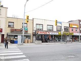
Bloordale Village is a Business Improvement Area (BIA) located along Bloor Street from Dufferin Street to Lansdowne Avenue, west of downtown in Toronto, Ontario, Canada. It sits on the southern border of the Wallace Emerson neighbourhood and the northern border of the Brockton Village neighbourhood. The district is home to various and unique shops including restaurants, bars, vintage and thrift stores.

<span class="mw-page-title-main">Dufferin Street</span> Roadway in Ontario, Canada

Dufferin Street is a major north–south street in Toronto, Vaughan and King, Ontario, Canada. It is a concession road, two concessions (4 km) west of Yonge Street. The street starts at Exhibition Place, continues north to Toronto's northern boundary at Steeles Avenue with some discontinuities and continues into Vaughan, where it is designated York Regional Road 53. The street is named for Frederick Hamilton-Temple-Blackwood, 1st Marquess of Dufferin and Ava, who served as Governor General of Canada from 1872 to 1878. Prior to 1878 the street was labelled as Western City Limits or Sideline Road south off Bloor. In 2003 and 2007, it was voted as one of "Ontario's Worst 20 Roads" in the Ontario's Worst Roads poll organized by the Canadian Automobile Association.

<span class="mw-page-title-main">Exhibition GO Station</span> Railway station in Toronto, Ontario

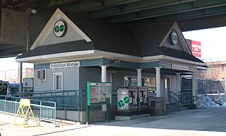
Exhibition GO Station is a GO Transit railway station in Toronto, Ontario, Canada. The station is one of the Lakeshore West line stations between Toronto and Hamilton. It is located west of downtown Toronto at Exhibition Place, an area of convention and exhibition venues, sports facilities, and other entertainment attractions, restaurants and nightclubs. It is also on the south side of Liberty Village, a former industrial area which has been redeveloped into a residential neighbourhood with retail and restaurants.

<span class="mw-page-title-main">Distillery District</span> Neighbourhood in Toronto, Ontario, Canada

The Distillery District is a commercial and residential district in Toronto, Ontario, Canada, east of downtown, which contains numerous cafés, restaurants, and shops housed within heritage buildings of the former Gooderham and Worts Distillery. The 13 acres (5.3 ha) district comprises more than forty heritage buildings and ten streets, and is the largest collection of Victorian-era industrial architecture in North America.

<span class="mw-page-title-main">Niagara, Toronto</span> Neighbourhood in Toronto, Ontario, Canada

Niagara is a neighbourhood in Toronto, Ontario, Canada, located south of Queen Street West; it is usually bordered by Strachan Avenue to the west, Bathurst Street to the east, and the railway corridor to the south, and so named because Niagara Street runs through the centre of it. The eastern portion of this area was first planned as the New Town Extension when Toronto was incorporated as a city. The area was developed as a residential area for the workers of industries located along the CN and CP railway corridors. It remains a working-class neighbourhood that has seen the development of new condominium apartment buildings.

<span class="mw-page-title-main">Downtown Toronto</span> Central business district in Toronto, Ontario, Canada

Downtown Toronto is the main central business district of Toronto, Ontario, Canada. Located entirely within the district of Old Toronto, it is approximately 16.6 square kilometres in area, bounded by Bloor Street to the northeast and Dupont Street to the northwest, Lake Ontario to the south, the Don Valley to the east, and Bathurst Street to the west. It is also the home of the municipal government of Toronto and the Government of Ontario.

<span class="mw-page-title-main">Little Jamaica</span> Neighbourhood of Toronto in Ontario, Canada

Little Jamaica, also known as Eglinton West, is an ethnic enclave in Toronto, Ontario, Canada. It is located along Eglinton Avenue West, from Marlee Ave to Keele Street, and is part of four neighbourhoods: Silverthorn, Briar Hill–Belgravia, Caledonia–Fairbank, and Oakwood–Vaughan. The commercial main street has been recognized to be of great cultural heritage significance to the city of Toronto, as a distinct ethnic and cultural hub for Afro-Caribbean immigrants for many decades.

<span class="mw-page-title-main">Little Portugal, Toronto</span> Neighbourhood in Toronto, Ontario, Canada

Little Portugal is a neighbourhood and ethnic enclave in Toronto, Ontario, Canada. It is located west of downtown in the "Old" City of Toronto. It is bound on the west by Lansdowne Avenue, on the north by College Street, on the east by Ossington Avenue and on the south by the Go Transit and Union Pearson Express railway tracks. The area is mainly residential, with Portuguese businesses along Dundas Street West and College Street. The area west of Dufferin Street was a part of the former Town of Brockton. The area to the east of Dufferin and south of Dundas Street is also known as "Beaconsfield Village" dating back to the days of the sub-division of lots in the area around Beaconsfield Avenue.

<span class="mw-page-title-main">History of neighbourhoods in Toronto</span>

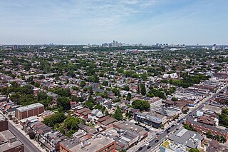
Throughout its history, Toronto has been a city divided into many districts and neighbourhoods. As the city has grown, new neighbourhoods have been created by expansion of the city into the countryside. Over time, the neighbourhoods within existing areas have also been altered and rearranged.

<span class="mw-page-title-main">Wallace Emerson</span> Neighbourhood in Toronto, Ontario, Canada

Wallace Emerson is a neighbourhood in Toronto, Ontario, Canada situated north of Bloor Street between Dufferin Street to the east, the CPR railway lines to the north and the CPR railway lines to the west.

<span class="mw-page-title-main">Dufferin Gate Loop</span> Bus station and streetcar turning loop in Toronto, Ontario, Canada

Dufferin Gate Loop, also known as Dufferin Loop, is a Toronto Transit Commission (TTC) bus station and turning loop for streetcars near the southern end of Dufferin Street in Toronto, Ontario, Canada. During the Canadian National Exhibition (CNE), the loop becomes a primary access point for visitors entering Exhibition Place via the Dufferin Gates. This west entrance to the CNE can be reached by the Dufferin Street bridges across the Lakeshore West railway corridor and Gardiner Expressway.

<span class="mw-page-title-main">Junction Triangle</span> Neighbourhood in Toronto, Ontario, Canada

Junction Triangle is a neighbourhood in Toronto, Ontario, Canada. It is located in the city's west end, just west of Lansdowne Avenue. The area is a triangle surrounded on all three sides by railway lines: the CNR/CPR mainline to the west, Metrolinx GO Transit Barrie line to the east, and the CPR east-west railway lines to the north. Bloor Street cuts across the middle of the neighbourhood, Dupont Street runs close to the northern edge, and Dundas Street is close to the southern boundary. By some accounts, the recent residential developments of Davenport Village and Foundry Lofts, built on former factory lands north of the CP Rail line, west of Lansdowne, south of Davenport and east of the GO Transit Bradford/Newmarket/Barrie line, also belong in this neighbourhood.

<span class="mw-page-title-main">Oakwood Village</span> Neighbourhood in Toronto, Ontario, Canada

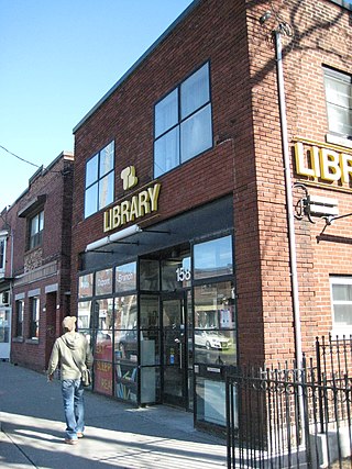
Oakwood Village, formerly known as Oakwood–Vaughan, is a neighbourhood in Toronto, Ontario, Canada. Located in the former suburb of York, the neighbourhood is a Business Improvement Area (BIA); it has an annual arts festival and a public library built in 1997.

Massey Harris Lofts is a loft condominium in Liberty Village area of downtown Toronto, Ontario, Canada. The building is the former head office of Massey-Harris Limited, later known as Massey Ferguson, a large agricultural implements manufacturer. It is the last building remaining from a large factory complex that Massey-Harris operated on King Street West from the 1870s until the 1980s.

References

  1. GeoSearch
  2. 1 2 3 4 5 6 7 Wieditz, Thorben (January 2007). "Liberty Village: The Makeover of Toronto's King and Dufferin Area" (PDF). Centre for Urban and Community Studies.
  3. 1 2 "Liberty Village Master Plan" (PDF). Liberty Village Business Improvement Area. August 2013.
  4. Allan, Antliff (19 February 2014). "Adrian Blackwell's Anarchitecture: The Anarchist Tension | if i can't dance to it, it's not my revolution". exhibits.haverford.edu/.
  5. "Liberty Village BIA". City of Toronto - BIA Listings. City of Toronto. Retrieved July 21, 2016.
  6. Hume, Christopher (March 8, 2008). "Liberty Village Highlights Poor Planning". Toronto Star.
  7. "Condo Showdown: Five Liberty Village Units for Under $550,000". Toronto Life. June 11, 2013.
  8. McKeen, Alex (March 2, 2018). "The GTA's Population is Booming". The Toronto Star.
  9. Micallef, Shawn (2017-11-17). "King St. pilot project does what big cities around the world are doing: Micallef". The Toronto Star. ISSN   0319-0781 . Retrieved 2017-12-01.
  10. "Construction of $11.5M King-Liberty pedestrian bridge to start this summer | CBC News".
  11. "Bridge spans to be installed over rail corridor in Liberty Village Sunday - CityNews Toronto".
  12. The film "Liberty Village - Somewhere in Heaven" on the Internet Movie Database (IMDb)