
Parkdale is a neighbourhood and former village in Toronto, Ontario, Canada, west of downtown. The neighbourhood is bounded on the west by Roncesvalles Avenue, on the north by the CP Rail line where it crosses Queen Street and Dundas Street. It is bounded on the east by Dufferin Street from Queen Street south, and on the south by Lake Ontario. The original village incorporated an area north of Queen Street, east of Roncesvalles from Fermanagh east to the main rail lines, today known as part of the Roncesvalles neighbourhood. The village area was roughly one square kilometre in area. The City of Toronto government extends the neighbourhood boundaries to the east, south of the CP Rail lines, east to Atlantic Avenue, as far south as the CN Rail lines north of Exhibition Place, the part south of King Street commonly known as the western half of Liberty Village neighbourhood.

Roncesvalles is a neighbourhood in the city of Toronto, Ontario, Canada, centred on Roncesvalles Avenue, a north–south street leading from the intersection of King and Queen Streets to the south, north to Dundas Street West, a distance of roughly 1.7 kilometres. It is located east of High Park, north of Lake Ontario, in the Parkdale–High Park provincial and federal ridings and the municipal Ward 4. Its informal boundaries are High Park to the west, Bloor Street West to the north, Lake Ontario/Queen Street West to the south and Lansdowne Avenue/rail corridor to the east. Originally known as "Howard Park", most of this area was formerly within the boundaries of Parkdale and Brockton villages and was annexed into Toronto in the 1880s.

Trinity—Spadina was a federal electoral district in Ontario, Canada, that was represented in the House of Commons of Canada from 1988 to 2015.
Dovercourt Park or Dovercourt Village is a neighbourhood in Toronto, Ontario, Canada situated north of Bloor Street between Christie Street to the east, the CPR railway lines to the north, and Dufferin Street to the west.

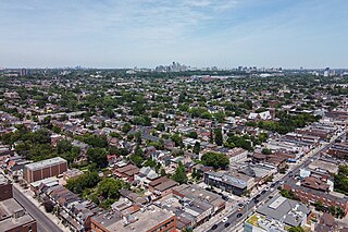
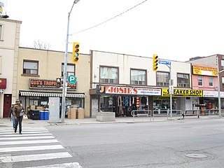
Bloordale Village is a Business Improvement Area (BIA) located along Bloor Street from Dufferin Street to Lansdowne Avenue, west of downtown in Toronto, Ontario, Canada. It sits on the southern border of the Wallace Emerson neighbourhood and the northern border of the Brockton Village neighbourhood. The district is home to various and unique shops including restaurants, bars, vintage and thrift stores.

Bloor Street is a major east–west residential and commercial thoroughfare in Toronto, Ontario, Canada. Bloor Street runs from the Prince Edward Viaduct, which spans the Don River Valley, westward into Mississauga where it ends at Central Parkway. East of the viaduct, Danforth Avenue continues along the same right-of-way. The street, approximately 25 kilometres (16 mi) long, contains a significant cross-sample of Toronto's ethnic communities. It is also home to Toronto's famous shopping street, the Mink Mile.

College Street is a principal arterial thoroughfare in downtown Toronto, Canada, connecting former streetcar suburbs in the west with the city centre. The street is home to an ethnically diverse population in the western residential reaches, and institutions like the Ontario Legislature and the University of Toronto in the downtown core. At Yonge Street, College continues to the east as Carlton Street.

Brockton Village is a former town, and now the name of a neighbourhood, in Toronto, Ontario, Canada. It comprises a section of the old Town of Brockton which was annexed by the City of Toronto in 1884.

Corso Italia is a neighbourhood in Toronto, Ontario, Canada, situated on St. Clair Avenue West, between Westmount Avenue and Lansdowne Avenue. It is contained within the larger city-recognized neighbourhood of Corso Italia-Davenport.

Bracondale Hill, also known as Hillcrest Village or Hillcrest, is a residential neighbourhood of Toronto, Ontario, Canada. Annexed by the old City of Toronto in 1909 and developed in 1911 from the Turner estate, Bracondale Hill is on the eastern border of West End Toronto; neighbouring Midtown, stretching above Davenport Road from the south, below St. Clair Avenue West from the north, Wychwood Park & Bathurst St. to the East and Winona Dr. to the West. This neighbourhood is home to the Hillcrest Village Business Improvement Area (BIA).

Dufferin Grove is a neighbourhood located in Toronto, Ontario, Canada, west of downtown. The neighbourhood is bordered by Bloor Street West to the north, Ossington Ave to the east, College Street to the south, and Dufferin Street to the west.
Fairbank is a neighbourhood in Toronto, Ontario, Canada. The area is centred on the intersection of Dufferin Street and Eglinton Avenue West. Fairbank includes the neighbourhoods of Briar Hill–Belgravia and Caledonia–Fairbank. The western border is the CNR lines. The northern and southern borders are the former borders of the City of York and the eastern border is Dufferin Street.
Bloorcourt Village is a Business Improvement Area in Toronto, Ontario, Canada along Bloor Street east of Dufferin Street. It is located on the southern edge of the Dovercourt Park neighbourhood. This is west of downtown, and located within the former City of Toronto.

Lansdowne Avenue is an arterial road in Toronto, Ontario. It runs north–south and starts at Queen Street West and proceeds north to St. Clair Avenue West. Lansdowne Avenue is primarily a four-lane arterial road, with two lanes regularly used for motor vehicle parking.

Wallace Emerson is a neighbourhood in Toronto, Ontario, Canada situated north of Bloor Street between Dufferin Street to the east, the CPR railway lines to the north and the CPR railway lines to the west.
Ossington Avenue is a main or arterial street in Toronto, Ontario, Canada, west of downtown. While the northern 3 kilometres (1.9 mi) of Ossington Avenue is residential, its southern terminus is popularly known as the Ossington Strip, an area popular for its dining, nightlife and shopping establishments.

Oakwood Village, formerly known as Oakwood–Vaughan, is a neighbourhood in Toronto, Ontario, Canada. Located in the former suburb of York, the neighbourhood is a Business Improvement Area (BIA); it has an annual arts festival and a public library built in 1997.

Runnymede is a neighbourhood in Toronto, Ontario, Canada located north of Bloor Street West between Jane Street and Runnymede Road north to Dundas Street West. It is located directly north of the former village of Swansea and west of the High Park North neighbourhood. The immediate area around Bloor Street is commonly known as Bloor West Village after the shopping area along Bloor Street, whereas the area to the north is considered the Runnymede neighbourhood.

Trinity-Bellwoods is an inner city neighbourhood in Toronto, Ontario, Canada. It is bounded on the east by Bathurst Street, on the north by College Street, on the south by Queen Street West, and by Dovercourt Road on the west. It has a large Portuguese and Brazilian community, and many local Portuguese-Canadian businesses are located along Dundas Street West, continuing west into Little Portugal; this stretch further west along Dundas is known as Rua Açores.

The Harbord streetcar line was an east-west line within the Toronto streetcar system. The route was named after Harbord Street even though only a small portion of the route was along the namesake street. One distinct characteristic of the route was its zip-zag nature, making many 90-degree turns onto the various streets along its route. The route was retired in 1966 when the Toronto Transit Commission (TTC) opened the Bloor–Danforth subway line, the city's first east-west subway line.


