Bayview Village

Last updated

Bayview Village
Neighbourhood
Bayview Village.JPG
Bayview Village.PNG
CountyFlag of Canada (Pantone).svg  Canada
Province Flag of Ontario.svg  Ontario
City Toronto
Established1850 Scarborough Township
Changed municipality1998 Toronto from City of Scarborough
Government
  City Councillor Shelley Carroll
  Federal M.P. Han Dong
  Provincial M.P.P. Vincent Ke

Bayview Village is a neighbourhood in Toronto, Ontario, Canada. It is part of the federal Don Valley North riding and the provincial Don Valley North electoral district, and Toronto electoral Ward 17: Don Valley North. In 2006, it had a population of 15,370. [1]

Contents

The area is bordered on the north by Finch Avenue East, on the west by Bayview Avenue, on the east by Leslie Street, and on the south by Highway 401, and also including the grounds of North York General Hospital, east of Leslie in the neighbourhood's southeast corner, according to the City of Toronto's definition. [1] The Bayview Village Association regards the east boundary as the Don River (east branch) and the south boundary as Sheppard Avenue East, thereby excluding land between the Don River and Leslie, Sheppard and Highway 401. [2]

History

Bayview Village Shopping Centre was opened in the neighbourhood in 1963. Bayview Village Shopping Centre.jpg
Bayview Village Shopping Centre was opened in the neighbourhood in 1963.

The Bayview Village neighbourhood was planned in 1954 by a group of developers led by Farlinger Development Ltd. Bayview Village was hailed as "contemporary living in the countryside, at the doorstep of the urban concentration of Metropolitan Toronto." The design and layout of Bayview Village is very much influenced by the East Don Valley Parklands. Dr E. G. Faludi, the town planner who designed Bayview Village, recognized the importance of the East Don Valley Parklands when he said: "We will fit the community into the landscape and not the landscape into the community." Faludi's trademark curvilinear street pattern follows the natural contours of the land. Nearly a quarter of the space in Bayview Village is green.[ citation needed ] Bayview Village's winding streets and culs-de-sac are planted with mature birch, cedar, willow, spruce, pine and maple trees. Some of the Bayview Village houses are situated on ravine lots that feature views of the East Don River Valley Parklands. Several of the street names in Bayview Village, such as Citation Drive, Palomino Cres., Ravenscroft Circle recall that the area was a racehorse training stable and grounds before being developed. In the Bayview Village area, there are United, Greek Orthodox, Catholic, and Anglican churches, the latter is located just outside the area's southwest boundary.

The Bayview Village Association was established in 1956. [3] It is a volunteer group of residents who work to monitor city and provincial initiatives on a wide range of topics including traffic, local development, parks, and safety. [3] In addition, they produce a regular newsletter distributed to all homes covering a wide range of topical issues. The Bayview Village Association also hosts a number of events throughout the year including clean-up days, all-candidates meetings, community fairs, speakers series, annual perennial swaps, etc. Over 50% of Bayview Village residents are members of the Association.

The Bayview Village Shopping Centre opened in 1963. It is located at the northeast corner of Sheppard Avenue and Bayview Avenue.

Architecture

Most Bayview Village homes were built between 1954 and 1964. The mix of housing here includes raised and executive ranch style bungalows, split-level houses, and Georgian Revival-style homes. Most of the houses are original. Many homes have undergone renovation and landscaping to fit the park-like neighbourhood. There has been increasing infill housing (newly built houses replacing the older ones) within the Bayview Village area.

High-rise developments were developed along Sheppard Avenue. Condo Towers Bayview Village.jpg
High-rise developments were developed along Sheppard Avenue.

There also continues to be high rise condominium development along Sheppard Avenue and in the land south of Sheppard Avenue and north of Highway 401. This development is of a completely different nature to the single-family suburban low-rise architecture found in the northern area.

Education

One public school board operate schools in Bayview Village, the secular English first language Toronto District School Board (TDSB).

TDSB operate public elementary schools in the neighbourhood. The TDSB operates two institutions that provide primary education, Bayview Middle School, and Elkhorn Public School.

No school board operates a secondary school in the neighbourhood, with CSV, and TDSB secondary school students residing in Bayview Village attending institutions in adjacent neighbourhoods. The public separate school board, Toronto Catholic District School Board (TCDSB), and its French first language counterpart, Conseil scolaire catholique MonAvenir (CSCM) also offer schooling to applicable residents of Bayview Village. However, they do not operate a school in the neighbourhood. CSCM and TCDSB students attend schools situated in other neighbourhoods in Toronto.

Recreation

The neighbourhood is home to the Bayview Village Tennis Club. BayviewVillageTennisClub.jpg
The neighbourhood is home to the Bayview Village Tennis Club.

The Bayview Village Tennis Club, home of "tennis ace" Daniel Nestor is a community tennis club serving Bayview Village since 1975. It was an initiative of the Bayview Village Association. The courts at Bayview Village Tennis Club were completely rebuilt at the end of the 2008 tennis season. Today, Bayview Village Tennis Club continues to be looked upon as the premier tennis club of North York. There are also free public tennis courts in Bayview Village Park.

The North York YMCA, located at the southeast corner of Bayview Avenue and Sheppard Avenue, is the largest recreational facility serving this neighbourhood. Some of the programs being offered at this YMCA include play-gym and swim lessons for preschoolers, gymnastics, karate, swimming and basketball programs for children, and aerobics, yoga and aquafit for adults. Facilities at this centre include a gymnasium, a dance studio, a conditioning room, a main swimming pool with lanes and a training swimming pool.

Parks

The East Don Parkland Trail south of Finch Avenue. East Don Parkland Trail - 20181230.jpg
The East Don Parkland Trail south of Finch Avenue.

The western edge of the East Don Parklands winds its way through the centre of Bayview Village and is a vast and expansive green haven with various trails, walkways and bicycle paths. The park's naturalization and preservation programs have made the space a habitat for wildlife and a number of rare plant species. The East Don Parklands is situated around the East Don River Valley, which forms a part of the larger Toronto ravine system.

There are many smaller parks and parkettes in Bayview Village including Alamosa Park, and Leslie Park. Blue Ridge Park, Clarinda Park and Bayview Village Park are child-focused, with baseball diamonds, splash pads and playgrounds. Municipal parks in Bayview Village are maintained by the Toronto Parks, Forestry and Recreation Division.

Transportation

Entrance to Leslie station, a station for the Toronto subway. TTC Leslie 2.jpg
Entrance to Leslie station, a station for the Toronto subway.

Several major roadways serve as the boundary of the neighbourhood, with Bayview Avenue to the west, Finch Avenue to the north, Leslie Street to the east, and Highway 401 to the south. Highway 401 is a major east-west controlled access highway. Other major east-west roadways in the neighbourhood include Sheppard Avenue.

Public transportation in Bayview Village is provided by the Toronto Transit Commission (TTC), which operates several bus routes, as well as Line 4 Sheppard of the Toronto subway. The subway may be accessed at three stations on Sheppard Avenue, Bayview, Bessarion, and Leslie station.

Related Research Articles

<span class="mw-page-title-main">Bridle Path, Toronto</span> Neighbourhood in Toronto, Ontario, Canada

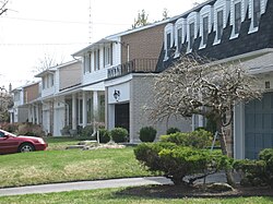
The Bridle Path is a residential neighbourhood in Toronto, Ontario, Canada. It is characterized by large multimillion-dollar mansions and two to four acre lot sizes. It makes up part of Bridle Path–Sunnybrook–York Mills. Often referred to as "Millionaires' Row", as of 2014 it is the most affluent neighbourhood in Canada, with an average household income of $936,137, as well as by property values with an average dwelling value of $2.24M.

<span class="mw-page-title-main">Agincourt, Toronto</span> Neighbourhood in Toronto, Ontario, Canada

Agincourt is a neighbourhood and former village in Toronto, Ontario, Canada. Agincourt is located in northeast Toronto, along Sheppard Avenue between Kennedy and Markham Roads. Before the creation of the "megacity" of Toronto in 1998, the area was part of Scarborough. It is officially recognized by the City of Toronto as occupying the neighbourhoods of Agincourt South–Malvern West and Agincourt North.

<span class="mw-page-title-main">Downsview</span> Neighbourhood in Toronto, Ontario, Canada

Downsview is a neighbourhood in the north end of Toronto, Ontario, Canada, located in the district of North York. The area takes its name from the Downs View farm established around 1842 near the present-day intersection of Keele Street and Wilson Avenue. It now extends beyond the intersection of Sheppard Avenue and Dufferin Street, though it is popularly seen as including the areas to the north right up to the Toronto city limit at Steeles Avenue. The area includes several large post-World War II subdivisions. Within the area is Downsview Airport, the former site of Canadian Forces Base Downsview, which has since been largely converted following the end of the Cold War into an urban park known as Downsview Park. The airport is still used as a manufacturing and testing facility for Bombardier Aerospace.

<span class="mw-page-title-main">Willowdale, Toronto</span> Neighbourhood in Toronto, Ontario, Canada

Willowdale is a neighbourhood in the city of Toronto, Ontario, Canada, located in the district of North York. It developed from three postal villages: Newtonbrook, Willowdale and Lansing.

<span class="mw-page-title-main">Henry Farm</span> Neighbourhood in Toronto, Ontario, Canada

Henry Farm is a neighbourhood in the City of Toronto, Ontario, Canada. It is located in the north central part of the city within the former city of North York.

<span class="mw-page-title-main">Humbermede</span> Neighbourhood in Toronto, Ontario, Canada

Humbermede, often called Emery, is a neighbourhood of Toronto, Ontario, Canada. Humbermede, like many of the "Humber" neighbourhoods in the city, gets its name from the Humber River. It is bounded on the west by the Humber River, on the north by Finch Avenue West, on the east by the Highway 400 and on the south by Sheppard Avenue West.

<span class="mw-page-title-main">Pelmo Park-Humberlea</span> Neighbourhood in Toronto, Ontario, Canada

Pelmo Park-Humberlea is a neighbourhood in Toronto, Ontario, Canada. It is located north-west of the central core, in the former suburb of North York. Many of the neighbourhoods in this quadrant of the city can aptly be described as family neighbourhoods with access to parks, green space and a slower pace than found closer to downtown.

<span class="mw-page-title-main">Lawrence Manor</span> Neighbourhood in Toronto, Ontario, Canada

Lawrence Manor is a neighbourhood in the city of Toronto, Ontario, Canada. This neighbourhood is bounded by Bathurst Street on the east, Highway 401 to the north, the Allen to the west, and Lawrence Avenue to the south. The western side of the area borders along Bathurst Heights and the large public housing project.

<span class="mw-page-title-main">Clanton Park, Toronto</span> Neighbourhood in Toronto, Ontario, Canada

Clanton Park is a neighbourhood in Toronto, Ontario, Canada. Located in the district of North York, it is part of federal and provincial electoral district York Centre, and Toronto electoral wards 9: York Centre (West) and 10: York Centre (East). In 2016, it had a population of 16,472, a 12.7% rise from 2011.

<span class="mw-page-title-main">Westminster-Branson</span> Neighbourhood in Toronto, Ontario, Canada

Westminster-Branson is a neighbourhood in the city of Toronto, Ontario, Canada. It is in the northernmost part of the city within the area of North York.

<span class="mw-page-title-main">Lansing, Toronto</span> Neighbourhood in Toronto, Ontario, Canada

Lansing is a neighbourhood in Toronto, Ontario, Canada. It originated as a minor settlement of a store, other services and a post office at the corner of Yonge Street and Sheppard Avenue and later got consolidated with Toronto as sprawling development took place. A larger area was designated as the postal village of Lansing. The City of Toronto labels it as Lansing-Westgate for neighbourhood planning purposes with the boundaries Yonge Street to the east, Highway 401 to the south, Bathurst Street to the west and Burnett Avenue to the north.

<span class="mw-page-title-main">Parkwoods</span> Neighbourhood in Toronto, Ontario, Canada

Parkwoods or sometimes referred to as Parkwoods-Donalda, is a neighbourhood in Toronto, Ontario, Canada. It is a geographically large neighbourhood located just south of Ontario Highway 401, west of Victoria Park Avenue, north of Lawrence Avenue East and east of the Don Valley Parkway.

<span class="mw-page-title-main">Pleasant View, Toronto</span> Neighbourhood in Toronto, Ontario, Canada

Pleasant View is a neighbourhood in the city of Toronto, Ontario, Canada that is located in the district of North York at the northern end of the city. It is bordered by Victoria Park to the East, Sheppard Avenue to the South, Highway 404 to the west and the Finch hydro corridor to the north. The neighbourhood is home to several high-rise apartment and condominium buildings, such as The Clippers.

<span class="mw-page-title-main">Don Valley Village</span> Neighbourhood in Toronto, Ontario, Canada

Don Valley Village is a neighbourhood in the city of Toronto, Ontario, Canada. It is located in the former suburb of North York. Located north of Highway 401 and bisected by Don Mills Road, it is bounded by Sheppard Avenue to the south, Leslie Street to the west, Finch Avenue to the north and Highway 404 to the east. Like the nearby Don River Valley, the neighbourhood has hill and dale topography.

<span class="mw-page-title-main">Bayview Woods-Steeles</span> Neighbourhood in Toronto, Ontario, Canada

Bayview Woods-Steeles is a neighbourhood located in the northern tip of the city of Toronto, Ontario, Canada in the district of North York. It is part of federal and provincial electoral district Don Valley North, and Toronto electoral ward 17: Don Valley North. In 2006, it had a population of 13,295. The area is divided by a series of ravines, and is often not considered a neighbourhood unto itself. Rather the sections are more often divided between the neighbouring areas of Hillcrest Village, Bayview Village, and Newtonbrook.

<span class="mw-page-title-main">Tam O'Shanter-Sullivan</span> Neighbourhood in Toronto, Ontario, Canada

Tam O'Shanter-Sullivan is a neighbourhood in the east end of the city of Toronto, Ontario, Canada, in the district of Scarborough. The neighbourhood is bordered by Huntingwood Drive to the North, Kennedy Road to the East, Highway 401 to the South and Victoria Park to the West. The neighbourhood, which includes the Tam O'Shanter and Sullivan communities, takes its name from Tam O’Shanter Golf Course and O'Sullivan's Corners.

<span class="mw-page-title-main">Rouge, Toronto</span> Neighbourhood in Toronto, Ontario, Canada

Rouge is a neighbourhood in the northeastern area of Toronto, Ontario, within the former city of Scarborough. It is Toronto's largest neighbourhood by surface area; however, unlike other neighbourhoods, most of its area remains undeveloped, as the neighbourhood is adjacent to Rouge National Urban Park.

<span class="mw-page-title-main">Morningside, Toronto</span> Neighbourhood in Toronto, Ontario, Canada

Morningside, also known as Seven Oaks, is a suburban neighbourhood in the city of Toronto, Ontario, Canada. It is located to the north-east of downtown Toronto, in the suburb of Scarborough. Morningside is bordered by Highway 401 to the north, Morningside Avenue to the east, West Highland Creek and Lawrence Avenue to the south and Scarborough Golf Club Road to the west.

<span class="mw-page-title-main">Maple Leaf, Toronto</span> Neighbourhood in Toronto, Ontario, Canada

Maple Leaf is a neighbourhood in the city of Toronto, Ontario, Canada. It is located in the southwest of the North York district. Its approximate borders are Lawrence Avenue to the south, Culford Road to the west, Highway 401 to the north, and the CNR rail lines east of Keele Street to the east.

<span class="mw-page-title-main">Armour Heights</span> Neighbourhood in Toronto, Ontario, Canada

Armour Heights is a neighbourhood in Toronto, Ontario, Canada, in the district of North York. It is bounded by Wilson Avenue to the south, Bathurst Street to the west, and the west branch of the Don River to the north and east. Highway 401 cuts through the centre of the neighbourhood.

References

  1. 1 2 "Data, Research & Maps". City of Toronto. 2017-07-14. Retrieved 2021-06-21.
  2. Bayview Village Association map Archived April 9, 2009, at the Wayback Machine
  3. 1 2 "Bayview Village Association" . Retrieved June 3, 2010.

43°46′37″N79°22′44″W / 43.777°N 79.379°W / 43.777; -79.379