Forest Hill is a neighbourhood and former village in Midtown Toronto, Ontario, Canada, located north of Downtown Toronto. The village was amalgamated into Toronto in 1967 and the area has retained its name as a neighbourhood. Along with other neighbourhoods such as Rosedale and The Bridle Path, it is one of Toronto's wealthiest and most affluent neighbourhoods. It is home to many prominent entrepreneurs, celebrities, engineers, doctors, and lawyers. Census data from Statistics Canada states an average income for all private households in Forest Hill to be $101,631, compared to the $40,704 average income in Toronto's Census Metropolitan Area.

Rosedale is a neighbourhood in central Toronto, Ontario, Canada. It was formerly the estate of William Botsford Jarvis, and so named by his wife, granddaughter of William Dummer Powell, for the wild roses that grew there in abundance. It is located north of Downtown Toronto and is one of its oldest suburbs. In 2013, Rosedale was ranked the best neighbourhood in Toronto to live in by Toronto Life. According to Today’s Senior Magazine, it is known as the area where the city's 'old money' lives, and is home to some of Canada's richest and most famous citizens including Gerry Schwartz, founder of Onex Corporation, Adrienne Clarkson, the 26th Governor General of Canada, and her husband, the author John Ralston Saul, as well as David Thomson, 3rd Baron Thomson of Fleet of the Thomson Corporation, the latter of whom is the richest man in Canada.

North Toronto is a former town and informal district located in the northern part of the Old Toronto district in Toronto, Ontario, Canada. Currently occupying a geographically central location within the city of Toronto, the Town of North Toronto was incorporated in 1890, when much of the area was still farmland, and annexed by Toronto in 1912. The name is still used to refer to the area in general, although Yonge–Eglinton and Midtown Toronto are officially used.

Deer Park is a neighbourhood in Toronto, Ontario, Canada. It is centered on the intersection of Yonge Street and St. Clair Avenue and its boundaries are the Vale of Avoca section of Rosedale ravine in the east, Farnham Avenue and Jackes Avenue in the south, Avenue Road and Oriole Parkway in the west, the Beltline Trail in the north on the west side of Yonge Street, and Glen Elm Avenue in the north on the east side of Yonge Street. For the purposes of social policy analysis and research, the Toronto government’s Social Development & Administration division includes Deer Park within the City of Toronto's official "Rosedale-Moore Park" and "Yonge-St.Clair" neighbourhood profiles. The neighbourhood is in Ward 22, represented by Councillor Josh Matlow at Toronto City Council.

St. Clair Avenue is a major east-west street in Toronto, Ontario, Canada. It was laid out in the late 18th century by the British as a concession road, 2 kilometres (1.2 mi) north of Bloor Street and 4 kilometres (2.5 mi) north of Queen Street.

Toronto—St. Paul's is a federal electoral district in Toronto, Ontario, Canada, that has been represented in the House of Commons of Canada since 1935. Its current MP is Carolyn Bennett. Prior to the 2015 election, the riding was known as St. Paul's.

St. Clair is a subway station on Line 1 Yonge–University in Toronto, Ontario, Canada. The station opened in 1954 as part of the original Yonge Street subway.

Vale of Avoca is the name of a large viaduct which carries St. Clair Avenue East over a ravine of the same name, in Toronto, Canada. Located just east of Yonge Street, the current triple arch bridge, also known as the St. Clair Viaduct, was built to connect the well-established community of Deer Park with the developing community of Moore Park in the 1920s. The bridge replaced an older structure and straightened the alignment of St. Clair Avenue in the process.
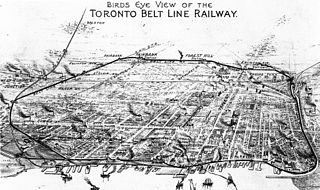
The Toronto Belt Line Railway was built during the 1890s in Toronto, Ontario, Canada. It consisted of two commuter railway lines to promote and service new suburban neighbourhoods outside of the then city limits. Both lines were laid as loops. The longer Don Loop ran north of the city limits, and the shorter Humber Loop ran west of the city limits. The railway was never profitable and ran for only two years. Today, as part of a rails-to-trails project, the Beltline Trail lies on the right-of-way of the Don Loop.

Bayview Woods-Steeles is a neighbourhood located in the northern tip of the city of Toronto, Ontario, Canada in the district of North York. It is part of federal and provincial electoral district Don Valley North, and Toronto electoral ward 17: Don Valley North. In 2006, it had a population of 13,295. The area is divided by a series of ravines, and is often not considered a neighbourhood unto itself. Rather the sections are more often divided between the neighbouring areas of Hillcrest Village, Bayview Village, and Newtonbrook.

O'Connor–Parkview is a neighbourhood in the East York area of Toronto, Ontario, Canada. While the name is taken from the definition used by the city of Toronto, local residents are more familiar with the niche areas that define the larger neighbourhood. It is a very diverse neighbourhood that includes English-speakers and Greeks in the west, to the Tamil speakers in the east and Bengali people in the south. It includes low-income highrises, to huge property lots. The smaller areas included inside the neighbourhood are Topham Park, Woodbine Gardens and Parkview Hills.

Humewood–Cedarvale is an area of Toronto, Ontario, Canada, consisting of Humewood in the south, divided by Vaughan Road and Cedarvale Ravine. The neighbourhood is bordered by Bathurst Street on the east, Eglinton Avenue to the north, Arlington Avenue to the west, and St. Clair Avenue to the south. Humewood has also been known as "the Woods" because of its many streets that have names ending with "-wood", including Wychwood, Humewood, Cherrywood, Valewood, Maplewood, Wellwood, Kenwood, and Pinewood. The neighbourhood's main commercial areas are along St. Clair Ave. W., referred to as Hillcrest Village and along Eglinton Ave. W..

Clairlea is a neighbourhood in Toronto, Ontario, Canada. The neighbourhood is located in the western part of the district of Scarborough just east of Victoria Park Avenue. To the north, it is bounded by Eglinton Avenue and to the south by Taylor-Massey Creek and the railway tracks. The neighborhood is served by Warden station and the Don Valley Parkway. A large portion of Clairlea-Birchmount is taken up by shopping centres, the Eglinton Square Shopping Centre and other large retail developments along what was once Scarborough’s old Golden Mile of Industry on Eglinton Avenue.

Carleton Village is a neighbourhood in the city of Toronto, Ontario, Canada. It is centered along Davenport Road, south of St. Clair Avenue West and surrounded on the other three sides by railway lines. The CNR/CPR mainline to the west, the CNR railway lines to the east, and the CPR east–west railway lines to the south.

Governor's Bridge is a bridge and small neighbourhood in Toronto, Ontario, Canada, located to the east of Rosedale and Moore Park neighbourhoods. Unlike them, it was part of the former city of East York. The neighbourhood is named for the Governor's Bridge that crosses the Moore Park Ravine from Douglas Crescent to Astley Avenue and connects the area to Rosedale. The bridge was built in 1923 and restored in 2000.

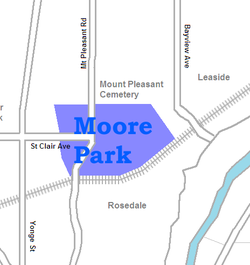
Mount Pleasant Road is a major arterial thoroughfare in Toronto, Ontario, Canada. The street extends from Jarvis Street south of Bloor Street north to Glen Echo Drive. The road is unique as one of the few arterial roads in Toronto to be created after the development of the suburbs which it passes through. These include the wealthy Rosedale, Moore Park and Lawrence Park neighbourhoods. The road also passes through the centre of Mount Pleasant Cemetery, after which it takes its name.
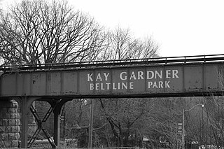
The Beltline Trail is a 9-kilometre (5.6 mi)-long cycling and walking rail trail in Toronto, Ontario, Canada. It consists of three sections, the York Beltline Trail west of Allen Road, the Kay Gardner Beltline Park from the Allen to Mount Pleasant Road, and the Ravine Beltline Trail south of Mount Pleasant Cemetery through the Moore Park Ravine. Built on the former right-of-way of the Toronto Belt Line Railway, the linear park passes through the neighbourhoods of Rosedale, Moore Park, Forest Hill, Chaplin Estates, and Fairbank.

Yellow Creek is a partially-buried southeasterly tributary of the Don River in Toronto. It has also been known at different times as Silver Creek, Sylvan Creek, and Rosedale Brook. The former source of Yellow Creek begins near Sheppard West station in the Downsview neighbourhood. Most of the creek and its sources are buried underground in storm sewers until they emerge into Avoca Ravine in the Deer Park neighbourhood and continue their way to the Don River.

David A. Balfour Park is an urban park in the Deer Park neighbourhood of Toronto near the intersection of Yonge Street and St. Clair Avenue. The park made up of 20.5 hectares of green space consisting of the greenery-covered Rosehill Reservoir and the entirety of the Vale of Avoca with its system of trails.